Story
Construction of the double-altar cathedral in the future village began in 1767, and 9 years later, upon completion of construction, it received the name Bogoslovsky . The Iron Smelting and Iron Works , launched in 1770, received the same name The settlement formed on this territory began to be called Bogoslovsk , and the entire industrial region received the status and name of the Bogoslovsky mountain district .
Photo source: Karpinsky Museum of Local Lore
In 1875, the mines and then the plant stopped working, which led to the sale of the Bogoslovsky mining district into private hands. “Private hands” became S.D. Bashmakov , who bought the district on April 11, 1875 for a little more than 2 million rubles. After his death, the district passed into the possession of N.M. Polovtsova , who had already given 6 million rubles for him. A.A. was appointed head of the district. Auerbach , whose efforts led to the launch in 1887 of a chemical plant on the right bank of the Turya River . Following it, glass, phosphorus and chrome-plate factories appeared.
Photo source: Karpinsky Museum of Local Lore
In the fall of 1883, a 16-kilometer-long railway appeared the Bogoslovsky mountain district of the Northern Urals . The purpose of the railroad was to transport minerals from the copper mines to the copper smelter. Its manager was Alexander Auerbach , engineer Fedor Auerbach . By the end of 1886, the railway had a total length of 54 kilometers and was named the Bogoslovsko-Sosvinskaya Railway (in honor of the route).
Brown coal deposits on the territory of Bogoslovsk became known back in 1849, but development of the deposit began only in 1911 - on November 19, the first excavator produced by the Putilov plant .
Photo by: Aare Olander
On December 7, 1917, the territory of the Bogoslovsky mining district was nationalized according to the decree of V.I. Lenin "On the Earth".
In April 1929, a detachment of former farm laborers from Bashkiria , who after some time began to acquire temporary housing in a new place. The number of barracks grew and, ultimately, a new settlement was formed - the village of Coal Mines .
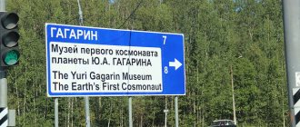
On June 20, 1933, the villages of Bogoslovsk and Ugolnye Kopi were united, receiving a common name - Ugolny . On March 31, 1941, the village of Ugolny received the status of a city of regional subordination and a new name - Karpinsk (in honor of the prominent geologist, first president of the USSR Academy of Sciences Alexander Petrovich Karpinsky ).
The post-war years became a period of revival of the economic sphere of life of the city - the construction of new plants and factories began, agriculture was developing, various enterprises began to function: a dairy plant, a brewery, a bakery, a sausage factory, a cotton spinning factory. The coal industry and mechanical engineering developed rapidly.
Photo source: Karpinsk.Info
In the nineties, the main city-forming enterprises began to close, which had a detrimental effect on the economic and socio-cultural life of the city. Young people began to move to large cities, schools and kindergartens were cut, cinemas were closed, and the number of libraries decreased.
Today, life in the city has leveled out; major enterprises operate here. For example, Karpinsky Electrical Machine-Building Plant , machine-building plant , bakery plant and others.
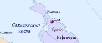
Map
| Karpinsk: maps |
Karpinsk: photo from space (Google Maps) Karpinsk: photo from space (Microsoft Virtual Earth)
| Karpinsk. Nearest cities. Distances in km. on the map (in brackets along roads) + direction. Using the hyperlink in the distance , you can get the route (information courtesy of the AutoTransInfo website) | |||
| 1 | Krasnoturinsk | 11 (13) | IN |
| 2 | Volchansk | 19 (25) | WITH |
| 3 | Serov | 36 (46) | SE |
| 4 | Severouralsk | 42 (50) | WITH |
| 5 | Kalya | 51 () | WITH |
| 6 | Cheryomukhovo | 64 () | WITH |
| 7 | Lobva | 71 (76) | SE |
| 8 | New Lyalya | 86 (99) | YU |
| 9 | Ivdel | 104 (124) | WITH |
| 10 | Verkhoturye | 109 (141) | SE |
| 11 | Kachkanar | 122 (194) | YU |
| 12 | Sosva | 123 (126) | SE |
| 13 | Forest | 126 (168) | YU |
| 14 | Nizhnyaya Tura | 128 (167) | YU |
a brief description of
Located on the eastern slope of the Northern Urals, on the river. Turya (Ob basin), 436 km north of Yekaterinburg. Railway station.
Territory (sq. km): 5523
Information about the city of Karpinsk on the Russian Wikipedia site
Historical sketch
Founded in 1759 on the river. Turya as a village in connection with the construction of the Turya iron smelting and ironworks (copper has been smelted since 1774).
After the construction of the temple, consecrated in the name of John the Theologian, the plant began to be called Bogoslovsky, and the village - Bogoslovsk.
Until 1917, one of the largest copper production centers in the Urals. Since 1911, the Bogoslovskoye coal deposit has been developed. Since August 27, 1928, the working settlement of Bogoslovsky. Since 1939, the reconstruction of the Bogoslovsky mines began.
The city of Karpinsk since 1941, was formed by the merger of the villages of Bogoslovsky and Ugolnye Kopi (Ugolny, town since 1928, 20.2 thousand inhabitants, 1939). Named in honor of the geologist, President of the USSR Academy of Sciences, Academician A.P. Karpinsky (1846-1936), a native of the Bogoslovsky plant.
During the Great Patriotic War of 1941-45, new industrial enterprises were built.
Municipal indicators
| Index | 2001 |
| Transport | |
| Length of operational tram tracks (at the end of the year), km | 0 |
| Number of passengers transported by trams per year, million people. | 0 |
Data sources:
- Transport in Russia: Statistical collection. Goskomstat. - M:, 2003. pp. 110, 120
Economy
Plants: ore repair (parts for repairing mining machines), machine-building, electrical machine-building. Yarn factory.
Brown coal mining.
Culture, science, education
Museum of Local Lore.
Museums, galleries, exhibition halls
Karpinsky Museum of Local Lore 624930, Sverdlovsk region, Karpinsk, st. Lesopilnaya, 71 Phone(s): (34383) 3-5062
Architecture, sights
In the historical core of the city, the former Bogoslovsky village, wooden buildings predominate. In new areas there are multi-storey buildings.
| Population by year (thousands of inhabitants) | |||||||
| 1897 | 4.5 | 1996 | 35 | 2008 | 29.1 | 2017 | 27.0 |
| 1931 | 4.9 | 1998 | 34.6 | 2010 | 28.5 | 2018 | 26.6 |
| 1959 | 49.5 | 2000 | 33.8 | 2011 | 29.1 | 2019 | 26.2 |
| 1967 | 41 | 2001 | 33.5 | 2012 | 28.6 | 2020 | 25.9 |
| 1970 | 38.0 | 2003 | 31.2 | 2013 | 28.2 | 2021 | 25.6 |
| 1979 | 36.7 | 2005 | 30.4 | 2014 | 28.1 | ||
| 1989 | 37.0 | 2006 | 30.1 | 2015 | 27.6 | ||
| 1992 | 36.1 | 2007 | 29.6 | 2016 | 27.3 | ||
Attractions
Karpinsky Museum of Local Lore
The museum was created in 1981. Today the museum offers 9 exhibition departments for viewing. Among them is the nature department of the Karpinsky region , reflecting the natural features of the region. Here you can see a collection of stuffed animals and birds, samples of rocks and minerals.
Photo source: Karpinsky Museum of Local Lore
The Hall of Military Glory will give visitors an idea of the events of the Civil War in Bogoslovsk and the Great Patriotic War of 1941-1945, and will tell about the contribution of Karpin residents on the battlefield and in the rear. There is also a separate exhibition “Behind the Barbed Wire of the Urals” , dedicated to the history of repressions in the Urals . The museum also features exhibitions dedicated to the development of the city’s industry (here, among other things, you can see models of various equipment), the life and work of the scientist and academician A.P. Karpinsky . Since 2015, the museum has opened a permanent exhibition “Gallery of Gennady Stepanovich Raishev” , where the works of the Honored Artist of Russia .
Sosvinsky stone
photo author: elena_shalamanova
Sosvinsky Stone is a mountain in the Karpinsky region , adjacent to the Main Ural Range . The stone received its name due to its location near the Bolshaya Sosva .
photo author: elena_shalamanova
The maximum height of the stone is 954.2 meters. Most of the stone is covered with forest, only the last 100 meters (in height) are covered with open forest, mountain tundra and scattered stones. Climbing to the top of the mountain is relatively simple - a person can climb it without special training or equipment.
photo author: elena_shalamanova
The closest landmark to the Sosvinsky Stone is the Zarya , located 110 kilometers from the city of Karpinsk . From the base there is a small clearing through the forest that will lead to the top point of the stone.
Festival "Konzhakovsky Accord"
“ Konzhakovsky Accord ” is an annual festival of bard music that brings together the best songwriters and performers of the Sverdlovsk region.
The festival has been held since 2010 at the starting site of the Konzhak marathon near the village of Kytlym, 60 km from Karpinsk. Traditionally, the “Konzhakov Accord” is held in the summer season and lasts two days.
Mount Serebryansky Stone
Author of the photo: Igor Krinitsyn
Serebryansky stone is considered one of the most beautiful mountains of the Konzhakovo-Serebryansky mountain range . The highest point of the mountain is 1305 meters above sea level. On the ascent you can find streams flowing from rocks and ledges, forming small waterfalls. In total, three mountain rivers flow from Serebryansky Stone , two of which flow into Lobva , and the third into Job .
The ascent of the mountain has a slight slope, but the path is hampered by periodically occurring kurums - fragments of rocks.
Vvedensky Cathedral
The first thing that attracts attention from the cathedral is its decor, the elements of which make it possible to classify it as a building in the Ural Baroque style (some argue that particles of the Siberian Baroque can also be seen here).
In 1930, the temple was closed and its bell tower was blown up. However, over time, the interior was restored, but the paintings of the temple remained original.
The Vvedensky Cathedral is also known as the burial place of the parents of radio inventor A.S. Popova . However, this is not entirely true - only the scientist’s father is buried in these places, while his mother was buried in the parish cemetery near the church in the name of the Kazan Icon of the Mother of God .
Karpinsk
(Sverdlovsk region)
OKATO code:
65445
Founded:
1759
Urban settlement since:
1928
City since:
1941 City of regional subordination
The city was formerly called:
| Theological | 1941 |
| Telephone code (reference phone) | |
| 34383***** | 22-5-99 |
Deviation from Moscow time, hours:
2
Geographic latitude:
59°46′
Geographic longitude:
60°00′
Altitude above sea level, meters:
210 Sunrise and sunset times in the city of Karpinsk
Karpinsk is on the list of “unfavorable” cities for living. But it gets better
The urban district of Karpinsk is classified as an area with a low level of urban environment - these are the results shown by a government study conducted at the end of 2020. We look at the official statistics and tell you what exactly is bad in Karpinsk, what the city has succeeded in, and whether there have been any improvements over the past three years.
All results of the study of the quality of the urban environment in Russian cities are published on the official website of the Ministry of Construction of the Russian Federation. To understand how favorable the urban environment of a given territory is, experts assessed it according to six criteria: roads, housing, landscaping, urban spaces, as well as public, business and social and leisure infrastructure. Simply put, where it is good for people to work and equally good to relax or play sports.
For each of the above criteria, the city was awarded points, the sum of which clearly shows and makes it possible to compare the level of the urban environment. We will return to these criteria a little later, in the “worse than average” block.
The maximum amount of points that could be scored is 360. If a territory has more than 180 points, the urban environment in it is considered favorable. If it is less than 180, it is unfavorable.
Not a single city in Russia has yet reached the level of 360 points. Even Moscow has 288 points. Of course, it is impossible to compare the capital and a small town in the north of the Sverdlovsk region. Therefore, all cities are divided into groups based on population.
Karpinsk was included in the group “Small towns with a population of 25-50 thousand people”. There are 16 cities in the Sverdlovsk region in this category, five of which have a favorable urban environment. Lesnoy has the best score - 216 points. Tavda has the worst score - 151 points.
The urban district of Karpinsk has 161 points, which is less than half the maximum value, so our city is classified as an area with a low level of urban environment. In the ranking of small cities in the Sverdlovsk region, Karpinsk occupies one of the last places. Only Kushva (156 points) and the above-mentioned Tavda (151 points) are worse.
Worse than average...
As we have already mentioned, the overall indicator of the quality of the urban environment was made up of six indicators, where the maximum score is 60. The website “index-city.rf” indicates exactly where Karpinsk fell short of being a “favorable” city.
If you believe the official indicators, not everything in Karpinsk is worse than average. For example, the level of improvement of the road network is 37 points out of 60.
Our city can also boast of a “citywide space” that scored 33 points, which is also more than half.
All other indicators are below average. The lowest score is for “public and business infrastructure” of Karpinsk - only 14. “Social and leisure infrastructure” - 28 points. Housing and landscaping - 24 and 25 points respectively.
...but it gets better
The website city-sreda.rf shows indicators for three years - from 2018 to 2021. Thanks to these data, you can see in which industry Karpinsk has developed and in which stagnation is occurring.
If we talk about the general indicator, then over the years the urban environment in Karpinsk is getting better. If in 2021 the overall score was 141, then in 2019 the level of the urban environment increased to 160 points. This was largely due to the sharply increased rate of improvement of the road network. At the same time, by 2021 the score for “citywide space” has increased.
But some indicators still remain the same - these are public, business and social and leisure infrastructure.
You can clearly see how the level of “favorability” of the city has changed according to all six factors in our infographics.