Krasnoturinsk is located in the Ural region on the territory of the Sverdlovsk region. It is an important industrial center in the region. It was classified as a single-industry town with a difficult socio-economic situation. The city of Krasnoturinsk appeared in 1944. Its area is 309.5 square kilometers. The population of Krasnoturinsk is 57,514 people.
Geography and history
Initially, the village of Turinskie Rudniki was located on the site of Krasnoturinsk. A. S. Popov, who is the discoverer of radio communications, was born in this locality. Traditionally this was a region of metallurgists. Various types of ore were mined and smelted here.
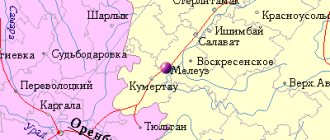
Krasnoturinsk is located on the eastern slope of the Ural Mountains, 370 km north of Yekaterinburg, near the Turya River. The distance to Moscow is 2079 km.
The climate is relatively continental, with cold, long and snowy winters. The average temperature of the coldest month is -19.7 degrees, and in winter in general -17 degrees. In January, frosts can reach -49 °C. Soil freezing in winter reaches 2 meters.
Summer is warm, with an average temperature of +17 °C. On some days the temperature can rise to +37 degrees. Precipitation varies from year to year from 381 to 668 mm, with an average of 518 mm. The first frosts are observed already in early September. Sometimes they happen even in summer. Real winter comes early - in the last days of October.
The city is surrounded by taiga-type forests consisting of spruce, fir, pine, and larch. Birch, rowan and aspen are also found.
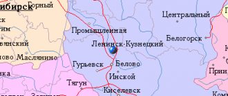
Routes on the map of Krasnoturinsk. Transport infrastructure
From the bus station there are flights to nearby settlements, and there are also long-distance routes to Yekaterinburg, Perm, Tyumen.
Ivdel-Serov highway is a bypass for Krasnoturinsk.
In the vicinity of the city there are railway lines connecting the regional center and Boksity, as well as Karpinsk and Serov.
The following stations of the Sverdlovsk Railway operate: Krasnoturinsk , Vorontsovka , Krasny Zheleznyak .
Urban transport is represented by buses and minibuses, which account for almost 100% of all passenger traffic within the city and in the suburban area.
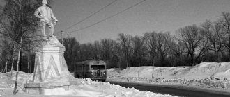
The Krasnoturinsky tram is rather a rarity:
- The tram service was opened in 1954.
- To date, this type of transport is not popular.
- There is one route with 3 carriages.
- The tram network is single-track, equipped with two sidings.
- The length of the tracks is 3.5 km. This is the shortest tram network in the country.
City population
The number of residents of Krasnoturinsk remained relatively stable until 1946. However, from the 40s to the 60s it increased approximately 6 times, after which it grew slowly and unsteadily until 1992. In 1939, the population was 9,600 people, in 1967 – 61,000 people, and in 1992 – 67,000 residents.
After 1992, the population of Krasnoturinsk generally declined, and in 2021 it amounted to 57,514 people. This corresponds to 295th place among the cities of the Russian Federation. A slight decline was observed in the 90s and a more significant one in the 2000s, starting in 2005. This decline was moderate, but continued continuously, year after year.
Economy and industry of Krasnoturinsk
The main industries of Krasnoturinsk are mining and metallurgy:
- The Bogoslovsky aluminum plant is the main enterprise of the city. BAZ is the leader in the production of alumina in the country, the raw material for it is bauxite from the local Severouralsk deposit;
- Bogoslovskoye Mining Administration – works at deposits of complex magnetite ores (containing copper, iron, cobalt, silver);
- Bogoslovskaya CHPP - supplies electricity and heat to Krasnoturinsk and the aluminum plant;
- gold, silver and platinum are mined;
The city's trading enterprises are represented by local and federal chains - Pyaterochka, Magnit, Euroset, Megafon, MTS.
Vacancies at the employment center of Krasnoturinsk
The list of vacancies published at the end of June 2021 shows a large number of available jobs. The city requires workers in a variety of specialties. There are quite a few engineering vacancies. Salaries there range from 20 to 30 thousand rubles. In other jobs, the amount of payments most often ranges from 13,500 to 20,000 rubles. The highest paid ones reach 37,000 rubles. Obviously, it is not easy to get a job with them.
The minimum salary level is 7475 rubles. - from a speech therapist teacher. The most unusual position is that of a piano tuner (salary 13,500 rubles).
Those who want to work as a dentist can count on a salary of 25,000 rubles, which is quite a bit for this profession.
As in other cities, in Krasnoturinsk you can get a job on a rotational basis. Salaries there are higher: from 68 to 172 thousand rubles. It's either the north or Siberia.
As a result, we can conclude that there should be no problems with employment in Krasnoturinsk.
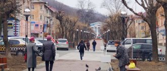
Main streets of Krasnoturinsk
There are 158 streets in Krasnoturinsk, among the main ones it is worth noting the following:
- Oktyabrskaya is an important transport route of the city. Extends from Karl Marx Street to Komsomolskaya Street. On Oktyabrskaya there is a bus station, the Geological Museum, the New Cinema cinema, religious sites - the Cathedral of Maxim the Confessor, the Alexander Nevsky Chapel, and the Nur Mosque.
- Lenina is the main street of the city, adjacent to the Central Square and Boulevard of Peace. Intersected by Metallurgov, Frunze, Karpinsky, Leninsky Komsomol streets. Here are the Puppet Theater, a branch of the Ural Federal University, the Krasnoturinsky Medical Center, a clothing market and numerous trade enterprises.
- Popova - stretches parallel to Oktyabrskaya Street, intersected by Karl Marx, Karpinsky and Frunze streets. The only city tram line runs here, the Popov Museum, Tikhomirovsky Park, a dental clinic, and the Northern Psychiatric Hospital are located.
A map of Krasnoturinsk with streets will give a more detailed idea of the structure of the city.
Settlements, administrative-territorial structure
Since 2021, the municipal formation (city district) and administrative-territorial unit (city) includes 5 settlements: 1 city, the rest rural. Until October 1, 2017, the Chernorechensky Village Council was allocated at the administrative-territorial level; the remaining rural settlements were directly included in the city as an administrative-territorial unit[29][30][31].
Administrative-territorial structure until October 1, 2017
| Administrative-territorial structure until October 1, 2017 | |||
| № | TE/ATE | Compound | Abolished after 1991 n.p. |
| 1 | Krasnoturinsk city | Krasnoturinsk | |
| 2 | s.n.p. | villages of Vorontsovka, Pribrezhny, Rudnichny, Shikhan | Vorontsovka village |
| 3 | Chernorechensky village council | Chernorechensk village | |
Settlements
| List of settlements | |||
| № | Locality | Type | Population |
| 1 | Vorontsovka | village | ↘870[18] |
| 2 | Krasnoturinsk | city, adm. center | ↘55 910[5] |
| 3 | Coastal | village | ↘243[18] |
| 4 | Rudnichny | village | ↘4035[18] |
| 5 | Chernorechensk | village | ↗281[18] |
On December 31, 2004, the working villages of Vorontsovka and Rudnichny were transformed into rural settlements[14].
Historically, the Vorontsovsky village council stood out, including the workers' village of Vorontsovka and the village of Shikhan[32].
On February 27, 2007, the village of Vorontsovka at the railway station of the same name was abolished as a populated area[33]. It should not be confused with the village of Vorontsovka, which had the status of a working village until 2004. To avoid confusion, the first one is conventionally referred to as Vorontsovka station
, the second is
the village of Vorontsovka
.
By Law of the Sverdlovsk Region dated November 1, 2021 No. 94-OZ, the village of Shikhan was abolished[34].
Notes
- status of a city of regional subordination
- urban district status
- Name
- ↑ 12
Sverdlovsk region. Total land area of the municipality - ↑ 123
The permanent population of the Russian Federation by municipalities as of January 1, 2021 (Russian). Date accessed: April 27, 2021. Archived May 2, 2021. - Ethnic map of the Ural Federal District by urban and rural settlements
- ↑ 123456789
Detailed map of the Sverdlovsk region with settlements, cities, districts - ↑ 12345678910111213
Krasnoturinsk - State Archives of the Sverdlovsk Region - Decree of the Presidium of the Supreme Soviet of the RSFSR dated November 22, 1966 “On the renaming of some settlements in the Sverdlovsk region”
- On the renaming of some settlements in the Sverdlovsk region (Russian). Russian Legal Portal
. Date accessed: May 5, 2021. Archived May 6, 2021. - ON ELECTIONS OF LOCAL GOVERNMENT BODIES (as amended as of December 6, 1995), Resolution of the Sverdlovsk Regional Duma of October 6, 1995 No. 279 (undefined)
. docs.cntd.ru. Date accessed: June 7, 2021. - Decree of the Governor of the Sverdlovsk Region of November 10, 1996 No. 409 “On approval of the regional register of municipalities”
- On establishing the boundaries of the municipal formation of the city of Krasnoturinsk and granting it the status of an urban district (as amended on July 12, 2007), Law of the Sverdlovsk Region of October 12, 2004 No. 105-OZ (unspecified)
. docs.cntd.ru. Date accessed: April 24, 2021. - ↑ 12
[https://docs.cntd.ru/document/802017412%7Ctitle=On the classification of the working village of Vorontsovka and the working village of Rudnichny, located within the administrative boundaries of the city of Krasnoturinsk, to the category of rural settlements as a type of village, Law of the Sverdlovsk Region dated October 12, 2004 year No. 119-OZ[ - Charter of the Krasnoturinsk urban district
- All-Russian population census 2002. Volume. 1, table 4. Population of Russia, federal districts, constituent entities of the Russian Federation, districts, urban settlements, rural settlements - regional centers and rural settlements with a population of 3 thousand or more (unspecified)
. Archived from the original on February 3, 2012. - The size of the permanent population of the Russian Federation by cities, urban settlements and regions as of January 1, 2009 (unspecified)
. Retrieved January 2, 2014. Archived January 2, 2014. - ↑ 1 2 3 4 5
Number and distribution of the population of the Sverdlovsk region (Russian) (inaccessible link).
All-Russian Population Census 2010
. Department of the Federal State Statistics Service for the Sverdlovsk Region and Kurgan Region. Date accessed: April 16, 2021. Archived September 28, 2013. - Sverdlovsk region. Estimated resident population as of January 1, 2009-2014
- Population of the Russian Federation by municipalities. Table 35. Estimated resident population as of January 1, 2012 (unspecified)
. Retrieved May 31, 2014. Archived May 31, 2014. - Population of the Russian Federation by municipalities as of January 1, 2013. - M.: Federal State Statistics Service Rosstat, 2013. - 528 p. (Table 33. Population of urban districts, municipal districts, urban and rural settlements, urban settlements, rural settlements) (undefined)
. Retrieved November 16, 2013. Archived November 16, 2013. - Population of the Russian Federation by municipalities as of January 1, 2014 (Russian). Date accessed: October 18, 2021. Archived August 2, 2014.
- Population of the Russian Federation by municipalities as of January 1, 2015 (unspecified)
. Access date: August 6, 2015. Archived August 6, 2015. - Population of the Russian Federation by municipalities as of January 1, 2021 (Russian) (October 5, 2018). Date accessed: May 15, 2021. Archived May 8, 2021.
- Population of the Russian Federation by municipalities as of January 1, 2021 (Russian) (July 31, 2017). Retrieved July 31, 2021. Archived July 31, 2021.
- Population of the Russian Federation by municipalities as of January 1, 2021 (Russian). Retrieved July 25, 2018. Archived July 26, 2021.
- Population of the Russian Federation by municipalities as of January 1, 2021 (Russian). Date accessed: July 31, 2019. Archived May 2, 2021.
- Population of the Russian Federation by municipalities as of January 1, 2021 (Russian). Date accessed: October 17, 2021. Archived October 17, 2021.
- On approval of the list of administrative-territorial units and settlements of the Sverdlovsk region in a new edition and recognition of paragraph 1 of Order No. 8-P dated January 11, 2016 as no longer in force, Order No. 28-P dated January 23, 2017
- Order of construction and infrastructure development of the Sverdlovsk region dated January 23, 2017 No. 28-P, original
- On measures to implement the Law of the Sverdlovsk Region “On the administrative-territorial structure of the Sverdlovsk Region”, Law of the Sverdlovsk Region dated April 13, 2021 No. 35-OZ
- Sverdlovsk region. Administrative division as of January 1, 1987
- {On the abolition of the village of Vorontsovka, located within the administrative boundaries of the city of Krasnoturinsk, Law of the Sverdlovsk Region of February 27, 2007 No. 2-OZ
- Law of the Sverdlovsk Region dated November 1, 2019 No. 94-OZ “On the abolition of the village of Shikhan, located on the territory of the administrative-territorial unit of the Sverdlovsk Region “Krasnoturinsk City””