Okha
(Sakhalin region)
OKATO code:
64236501
Founded:
1925
Urban settlement since:
1929
City since:
1938 City of regional subordination
Center:
Okha district
Telephone code (reference phone)
| 42437***** |
Deviation from Moscow time, hours:
8
Geographic latitude:
53°35′
Geographic longitude:
142°56′
Altitude above sea level, meters:
30 Sunrise and sunset times in the city of Okha
Climate[ | ]
The city of Okha belongs to the regions of the Far North, although it is located south of Moscow. The Sea of Okhotsk and the cold East Sakhalin Current cause a harsh climate (moderately cold marine).
- Average annual air temperature - minus 0.2 °C
- Relative air humidity - 71.7%
- Average wind speed - 6.3 m/s
| Average daily air temperature in Okha[4] | |||||||||||||
| Month | Jan | Feb | Mar | Apr | May | Jun | Jul | Aug | Sep | Oct | But I | Dec | Year |
| Wed. maximum, °C | −13,9 | −12,5 | −6,6 | 2,5 | 10,8 | 18,7 | 22,1 | 21,3 | 15,3 | 6,2 | −3,4 | −10,3 | 4,3 |
| Wed. temperature, °C | −17,9 | −17,2 | −12,1 | −2,0 | 6,0 | 13,2 | 16,7 | 16,1 | 10,9 | 3,0 | −6,6 | −13,9 | −0,2 |
| Wed. minimum, °C | −21,9 | −21,7 | −17,8 | −6,6 | 1,3 | 7,9 | 11,6 | 11,4 | 7,1 | 0,0 | −9,7 | −17,4 | −4,6 |
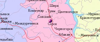
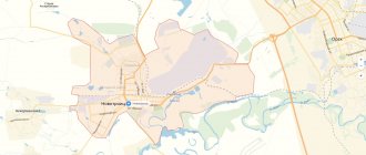
Map
| Okha: maps |
Okha: photo from space (Google Maps) Okha: photo from space (Microsoft Virtual Earth)
| Oha. Nearest cities. Distances in km. on the map (in brackets along roads) + direction. Using the hyperlink in the distance , you can get the route (information courtesy of the AutoTransInfo website) | |||
| 1 | Nikolaevsk-on-Amur | 153 () | Z |
| 2 | Nogliki | 197 (225) | YU |
| 3 | Bogorodskoye (Khabarovsk Territory) | 214 () | SW |
| 4 | Alexandrovsk-Sakhalinsky | 303 (414) | YU |
| 5 | Tymovskoye | 304 (358) | YU |
a brief description of
The city is located in the north-eastern part of Sakhalin Island, on the coast of Urqt Bay, 402 km from the railway. Nogliki station, 1062 km north of Yuzhno-Sakhalinsk. Connected by railway line with the port of Moskalvo.
Territory (sq. km): 14816
Information about the city of Okha on the Russian Wikipedia site
Historical sketch
In 1880, an oil field was discovered, near which the village of Okhe (later Okha) grew up. However, after several unsuccessful attempts to find oil, the village was abandoned. In the list of populated areas of Sakhalin for 1900, Okha is not listed. In 1908 there was no settlement on this site.
In 1920-25 was occupied by Japan. The first industrial oil was produced in 1921. Many old-timers believe that Okha was founded in 1925. In October 1925, Okha became the center of the Eastern (later Okha) region.
Workers' settlement of Okha from September 23, 1929. City from November 16, 1938.
Name of the city by river Okha; hydronym from Evenk ohe “bad, tasteless”, which is associated with the pollution of the river by oil seeps.
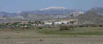
Economy
Okha is a major center of the oil and gas industry of Sakhalin. PA "Sakhalinmorneftegaz". From Okha, oil is supplied via an oil pipeline to Komsomolsk-on-Amur.
CHP.
Factories: mechanical, woodworking, reinforced concrete products and wall materials. Fishery plant, etc.
Main enterprises
THERMAL POWER PLANTS
DAOOT "Okha CHPP"
694460, Sakhalin region, Okha, 3rd km
Offers:
Electric and thermal energy
OIL PRODUCTION INDUSTRY
OJSC "Rosneft-Sakhalinmorneftegaz"
694460, Sakhalin region, Okha, st.
Lenina, 24 Offers:
oil, natural gas, well drilling
BUILDING MATERIALS INDUSTRY
OJSC "Sakhalinmorneftemontazh"
694460, Sakhalin region, Okha, st.
Sovetskaya, 26 Offers:
Construction lime, fine building materials, construction sand, sand-gravel mixture, precast reinforced concrete, ready-mixed concrete
Culture, science, education
Scientific Research and Design Institute "SakhalinNIPImorneft".
Museums, galleries, exhibition halls
Okha Museum of Local Lore 694490, Sakhalin region, Okha, st. Sovetskaya, 1 Phone(s): (42437) 2-24-91
| Population by year (thousands of inhabitants) | |||||||
| 1931 | 7.7 | 1996 | 31.7 | 2008 | 26.4 | 2017 | 20.9 |
| 1939 | 19.6 | 1998 | 29.4 | 2010 | 25.9 | 2018 | 20.7 |
| 1959 | 27.6 | 2000 | 28.2 | 2011 | 23.0 | 2019 | 20.4 |
| 1967 | 30 | 2001 | 28.4 | 2012 | 22.3 | 2020 | 20.0 |
| 1970 | 30.9 | 2003 | 28.0 | 2013 | 21.8 | 2021 | 19.8 |
| 1979 | 32.9 | 2005 | 27.2 | 2014 | 21.5 | ||
| 1989 | 36.1 | 2006 | 26.9 | 2015 | 21.2 | ||
| 1992 | 37 | 2007 | 26.7 | 2016 | 21.1 | ||
Etymology[ | ]
The Okha River was first mentioned in the petition of the merchant A. V. Karamushko from the city of Nikolaevsk-on-Amur dated July 7, 1880. It is possible that the name Okha comes from the Evenki word “okha”, meaning the skin from the legs of a reindeer. However, this word also has the meaning of “evil, bad,” which is associated with numerous surface oil shows. Taking this into account, the name “okha” should be translated as “bad place.” The Nivkh name of Okha - Vyrgyt - comes from the word “vyrkg’ytt” - to rot, deteriorate, deteriorate and is translated as “rotten place”. There is also such a legend: once the deer, frightened by the hunters, rushed to run through the green mari, and one fell into a deep muddy “window”. When the hunters pulled out the unfortunate animal using cut branches, they saw that the deer’s legs and stomach were smeared with a black oily liquid. A young Evenk, who noticed that the skin in these places was bursting and blood was oozing, exclaimed: “Okha!”, which in Evenki means “bad,” “evil,” “thin”[3].
Population[ | ]
| Population | ||||||||
| 1925 | 1931[5] | 1935 | 1937[6] | 1939[7] | 1959[8] | 1967[5] | 1970[9] | 1979[10] |
| 7700 | →7700 | ↗18 400 | ↗18 900 | ↗19 601 | ↗27 636 | ↗30 000 | ↗30 890 | ↗32 925 |
| 1989[11] | 1992[5] | 1996[5] | 1998[5] | 2000[5] | 2001[5] | 2002[12] | 2003[5] | 2005[5] |
| ↗36 104 | ↗37 000 | ↘31 700 | ↘29 400 | ↘28 200 | ↗28 400 | ↘27 963 | ↗28 000 | ↘27 200 |
| 2006[5] | 2007[5] | 2008[5] | 2009[13] | 2010[14] | 2011[15] | 2012[16] | 2013[17] | 2014[18] |
| ↘26 900 | ↘26 700 | ↘26 400 | ↘26 149 | ↘23 008 | ↘22 893 | ↘22 349 | ↘21 830 | ↘21 495 |
| 2015[19] | 2016[20] | 2017[21] | 2018[22] | 2019[23] | 2020[24] | 2021[1] | ||
| ↘21 203 | ↘21 081 | ↘20 916 | ↘20 715 | ↘20 391 | ↘20 016 | ↘19 783 | ||
As of January 1, 2021, in terms of population, the city was in 671st place out of 1,116[25]cities of the Russian Federation[26].
The population of Okha decreased significantly after the 1995 earthquake that occurred in the village of Neftegorsk, 98 km south of Okha and became destructive for the entire village. Many buildings in Okha were also damaged or destroyed. The entire Okha region suffered. From 1996 to 2021, a third of the population has left the city, most of them moving to the mainland.
Transport[ | ]
As of January 1, 2013, Okha has air and bus connections with other settlements in the Sakhalin region and cities of Russia.
The railway service (the Okha - Moskalvo line and the Okha - Nogliki railway line) was discontinued in December 2006 due to the dismantling of the Okha - Nogliki railway. The Okha - Moskalvo 1520 mm gauge railway line was dismantled in 1999. A monument to the steam locomotive remains.
Air transport[ | ]
Main article: Okha (airport)
Air communication is carried out through Okha Airport. The main destinations are Khabarovsk, Yuzhno-Sakhalinsk.
Road transport[ | ]
Currently, construction and repair of the road to the south of the island, in the direction of Nogliki, is underway. There is a bus station that connects the regional center with the settlements of Moskalvo, Nogliki, Nekrasovka, Tungor, Ekhabi, Vostochnoye, Sabo, Laguri.
Notes[ | ]
- ↑ 123
The permanent population of the Russian Federation by municipalities as of January 1, 2021 (Russian). Date accessed: April 27, 2021. Archived May 2, 2021. - Decree on conferring the honorary title “City of Labor Valor”
- Galtsev-Bezyuk S. D.
Toponymic dictionary of the Sakhalin region. — Yuzhno-Sakhalinsk: Far Eastern Book Publishing House. Sakhalin branch, 1992. - P. 224. - ISBN 5-7440-0136-0. - Meteorological statistics for the Sakhalin region
- ↑ 123456789101112
People's encyclopedia "My City". Okha - The resettlement policy of the Soviet state as a method of developing the territory of northern Sakhalin: 1925-1945
- All-Union Population Census of 1939. The size of the urban population of the USSR by urban settlements and intra-city areas (unspecified)
. Retrieved November 30, 2013. Archived November 30, 2013. - All-Union Population Census of 1959. The size of the urban population of the RSFSR, its territorial units, urban settlements and urban areas by gender (Russian). Demoscope Weekly. Access date: September 25, 2013. Archived April 28, 2013.
- All-Union Population Census of 1970 The size of the urban population of the RSFSR, its territorial units, urban settlements and urban areas by gender. (Russian). Demoscope Weekly. Access date: September 25, 2013. Archived April 28, 2013.
- All-Union Population Census of 1979 The size of the urban population of the RSFSR, its territorial units, urban settlements and urban areas by gender. (Russian). Demoscope Weekly. Access date: September 25, 2013. Archived April 28, 2013.
- All-Union population census of 1989. Urban population (undefined)
. Archived from the original on August 22, 2011. - All-Russian population census 2002. Volume. 1, table 4. Population of Russia, federal districts, constituent entities of the Russian Federation, districts, urban settlements, rural settlements - regional centers and rural settlements with a population of 3 thousand or more (unspecified)
. Archived from the original on February 3, 2012. - The size of the permanent population of the Russian Federation by cities, urban settlements and regions as of January 1, 2009 (unspecified)
. Retrieved January 2, 2014. Archived January 2, 2014. - All-Russian population census 2010. Sakhalin region. Population of urban districts, municipal districts, urban and rural settlements, urban settlements, rural settlements (undefined)
. Retrieved July 28, 2014. Archived July 28, 2014. - Sakhalin region. Estimated resident population as of January 1, 2011-2016
- Population of the Russian Federation by municipalities. Table 35. Estimated resident population as of January 1, 2012 (unspecified)
. Retrieved May 31, 2014. Archived May 31, 2014. - Population of the Russian Federation by municipalities as of January 1, 2013. - M.: Federal State Statistics Service Rosstat, 2013. - 528 p. (Table 33. Population of urban districts, municipal districts, urban and rural settlements, urban settlements, rural settlements) (undefined)
. Retrieved November 16, 2013. Archived November 16, 2013. - Table 33. Population of the Russian Federation by municipalities as of January 1, 2014 (unspecified)
. Access date: August 2, 2014. Archived August 2, 2014. - Population of the Russian Federation by municipalities as of January 1, 2015 (unspecified)
. Access date: August 6, 2015. Archived August 6, 2015. - Population of the Russian Federation by municipalities as of January 1, 2021 (Russian) (October 5, 2018). Date accessed: May 15, 2021. Archived May 8, 2021.
- Population of the Russian Federation by municipalities as of January 1, 2021 (Russian) (July 31, 2017). Retrieved July 31, 2021. Archived July 31, 2021.
- Population of the Russian Federation by municipalities as of January 1, 2021 (Russian). Retrieved July 25, 2018. Archived July 26, 2021.
- Estimated population by municipalities as of 01/01/2019 and the annual average for 2018 (unspecified)
. Territorial body of the Federal State Statistics Service for the Sakhalin Region (April 22, 2019). Date accessed: April 25, 2021. Archived April 25, 2021. - Population of the Russian Federation by municipalities as of January 1, 2021 (Russian). Date accessed: October 17, 2021. Archived October 17, 2021.
- taking into account the cities of Crimea
- https://rosstat.gov.ru/storage/mediabank/bul_Chislen_nasel_MO-01-01-2021.rar Population of the Russian Federation by municipalities as of January 1, 2021 (1.85 Mb, 07/30/2021)