The most interesting places in the Rostov region - TOP-3
A great number of natural monuments and reserves are registered on Rostov soil. Every tourist should see the most impressive creations of nature.
Biosphere Reserve "Rostovsky"
- Coordinates on the map: 46.464722, 43.050556.
The main natural reserve of the region has the status of a reserve of federal significance and covers the territory of the Remontnensky and Oryol districts, which is about 9,500 hectares. Most of the reserve, founded at the end of 1995, is occupied by endless desert steppes with saline soil, so the local flora is resistant to salts. The flora includes more than 400 species, 6 of which are included in the Red Book of Russia and another ten are listed in the Red Book of the region.
Many insects flock to the fragrant plants, including such rare species as the steppe bumblebee, Hungarian ground beetle and Bolivaria short-winged. Numerous birds nest near the river, including endangered species.
Wolves and foxes prowl along the valley steppes of the Manych River, horned saigas and delightful Manych mustangs gallop. In the grass you can see nimble field rodents, hares and hedgehogs. Tourists should be careful: there are a lot of snakes crawling on the ground, most of them are non-poisonous, but quite aggressive. Feeling a threat, reptiles can attack a person and bite the skin until they bleed.
Mountains Two Sisters
- GPS coordinates: 48.120571, 40.733055.
The two peaks are not the only mountains on the shore of the Northern Donets, but they stand out among their neighbors due to their height and extraordinary similarity to each other. Many people note that the twin mountains look like gigantic reptiles. It’s as if two huge lizards with protruding stone ridges have crawled to a watering hole and are lying side by side, with their heads directed towards the river.
The area has long been overgrown with myths and legends; the most famous one says that the peaks are enchanted sisters. Scientists give a very specific and realistic explanation for the natural phenomenon.
The hundred-meter-high mountains were formed about a million years ago as a result of the movement of the earth’s crust, when giant layers of limestone rose to the surface of the earth and over time became overgrown with greenery. Today, a floodplain forest separates the mountains at the foot, and clean freshwater springs rustle among the trees.
Long, or Long Canyon
- Coordinates: 48.228853, 40.349719.
A delightful canyon in the Kamensky district is a piece of the North American landscape in the middle of the steppe of the Rostov region. At the foot of the cliff flows an azure river, whose waters are so clean and transparent that through them you can see almost every pebble at the bottom.
Oddly enough, this amazing attraction appeared only in the last century and partly due to the fault of man. During Soviet times, there was a quarry here where stone was mined for construction work.
One day the quarry began to fill with groundwater and the huge pit was flooded to the very top in a matter of hours. Some of the equipment remained under water, which they did not have time to lift to a higher ground. The river is still fed by underground springs, so its waters remain cold even in hot weather.
Merzhanovsky lighthouse
- Address: Merzhanovo village, Neklinovsky district.
Not far from Taganrog, near the village of Merzhanovo, there is this man-made landmark of the Rostov region, which appeared relatively recently - as a set for the film “The Lighthouse Keeper”. Today, tourists happily visit this exciting place, mentally immersing itself in the distant past.
Loga Park
- Address: Loga Park, village. Staraya Stanitsa
In the area of the village of Staraya Stanitsa, near Kamensk-Shakhtinsky, there is Loga Park, where visitors can enjoy a lot of interesting entertainment and attractions, including the most popular - Crooked Mirrors. This place was included in our rating because it is truly unique - there are only a few like it in all of Russia. As the reviews say, when you relax here, you relax your soul!
Southern Bird Park "Malinki"
- Address: Krasny Sulin, PSH Sokolovskoye.
An interesting recreation park of regional significance is located near Novoshakhtinsk. “Malinka” itself will delight you with a unique “collection” of birds that you can see with the whole family. The territory is well designed, there is a lot of interesting things here, there are gazebos and bungalows near the shore of a neighboring reservoir, and beaches.
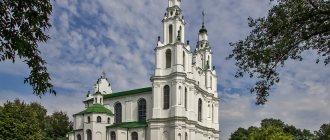
City of Donetsk, Rostov region
The city of Donetsk , formed in the 17th century by the Don Cossacks. Became a city in 1951 .
- There is a wonderful local history museum with eight exhibition halls and an impressive collection of exhibits.
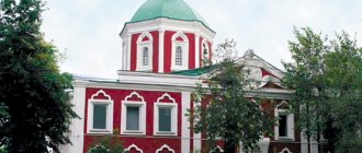
- The largest operating Orthodox church in the city is the Holy Assumption Church with a bell tower, opened back in 1860.
- In the village of Mikhailovka, near Donetsk, there is a ferry crossing across the Seversky Donets River (after which the city was named).
Rostov region: the most beautiful nature reserves
The main task of the Rostov nature reserves is to preserve and replenish the unique nature of the steppes and rare forests. In many protected areas, conditions have been created for recreation, fishing and hunting.
Natural Park "Donskoy"
- Coordinates: 47.184838, 39.285030.
The extensive natural park was founded in 2005, when it included four districts of the region with a total area of more than 40,000 hectares. The protected land is divided into two unequal sections: the large “Don Delta” and the smaller “Ostrovny”.
The fauna and flora of the first section are immensely rich even in comparison with the deltas of other large rivers; in the protected area there are more than 1000 species of birds, mammals and insects and more than 800 species of plants.
In addition to scientific and environmental activities, ecotourism is actively developing in the park; ecological trails and routes are being developed for guests of the reserve.
Mukhina beam
- Coordinates: 47.271565, 39.887148.
The large ravine in the vicinity of Aksai is a nature reserve and one of the most beautiful and mysterious places in the Rostov region. The area received its first name – Small Log – back in the 18th century. Later the log was renamed Ryabinovaya Balka.
Years later, the territory passed into the possession of the Mukhins, timber merchants, and the beam received the name of the new owners. The slopes of the ravine are covered with trees, as well as medicinal herbs and steppe plants, such as dandelion, feather grass, plantain, bluegrass, fescue, wormwood, etc. The bottom of the ravine is hidden under the dark waters of the swamps.
There is an unusual place in the beam that deserves special attention. Black holes gape on the bare sandy slope - entrances to underground tunnels. It is still unknown who created these caves; it is believed that the underground passages served as a refuge for the Cossacks. A little further away there is a museum of military equipment. An exhibition of tanks, armored personnel carriers and other vehicles was located right in the open air.
Despite its environmental status, the reserve suffers more and more from human activity every year. Forests and swamps are polluted, more and more plots of land are being given over to development.
Ilyichevskoe tract
- Coordinates: 47.133333, 42.611944.
Forest is a rare phenomenon for the Rostov region, so it is not surprising that the forest area near the Ilyichev farm received the status of a botanical monument. The tract is relatively small, its area is only 145 hectares. It came under state protection in 1985. It is home to dozens of bird species:
- pheasant and black kite,
- little bustard and eagle owl,
- owl and woodpecker,
- gray partridge and hawk,
- warbler and magpie,
- tit and many others.
The reserve is home to large populations of wild boars, roe deer and sika deer; large herbivores are hunted by local predators - jackals and wolves. The latter are found in three types - black, red and brown.
In 2002, an enclosure for breeding wild boars was built in the tract, and two years later new piglets appeared in the forest. Local specialists also work with other animals; during hungry winters, people feed roe deer and saigas and try to preserve rare species.
Tsimlyansky reserve
- Coordinates: 47.905000, 42.561389.
The lands from the Tsimlya River up to the Tsimlyansk Reservoir were recognized as protected areas in 1983. A significant part of the territory is covered with sand and looks like a desert. The desert image is complemented by sparse vegetation and snakes crawling along the sand. Nevertheless, the Tsimlyansky reserve boasts a variety of flora and fauna.
Most of the reserve is covered with forests and steppe. Dozens of years ago, experts planted pine trees in the reserve to strengthen the soil. Today, pine forests rustle at the planting site. In total, the reserve has several hundred plant species, of which 29 are listed in the Red Book.
About 230 species of animals, including 140 species of birds, have chosen the territory near the Tsimlyansk Reservoir. Birds hunt fish and nest on the shore. Many birds and insects are on the verge of extinction and are especially protected by the state. Tourists can see such rare species as the bustard and the great bustard, and if they are lucky, they can watch roe deer, deer and elk.
Chernyshevsky Sands
- Coordinates: 49.883333, 41.416667.
The forest tract in the Oblivsky district has been a specially protected area since 1977. The main task of the reserve was to stabilize shifting sands. For this purpose, pine, birch, acacia and other trees were planted on an area of 100 hectares. Today, medicinal herbs grow among the sands and overgrown plantings. Artificial forests have become habitats for hedgehogs, hares, foxes and other animals.
Kuleshovsky reserve
- Coordinates: 47.092726, 39.570996.
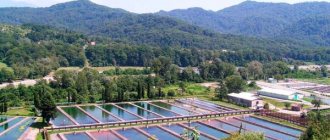
A large natural monument near the village of Kuleshovka occupies an area of about 10,000 hectares. The reserve acquired a special status in 1999. The protected lands are of great commercial importance; wheat, sunflowers, and vegetables are grown in the fields; fish, in particular silver carp and carp, are bred in the reservoirs.
Stocked ponds, numerous rivers, lakes and eriks, in turn, attract birds. Mute swan, pine tree, marsh harrier, greylag goose, bittern and many other feathered inhabitants nest on the banks. The most common mammals found on the site are foxes, muskrats, hedgehogs, weasels and hares.
Alexander Forest
- Coordinates on the map: 46.744386, 39.131027.
The Alexandrovsky Reserve, with an area of more than 5,000 hectares, was created in 1884 in the Azov region, one hundred kilometers from Rostov-on-Don. The mixed coniferous-deciduous forest is the habitat of dozens of animal species. In its open spaces one can find a raccoon dog, an owl, a heron, a fox, a hare and many other mammals and birds. Pheasants are bred on a farm in the central part of the reserve, and there is also a special nursery for deer.
During the season, for a certain amount of money you can hunt in the forest, but most tourists come just to admire the wonderful animals. Of particular delight are the red deer, which majestically stride among the trees and bushes, trying not to touch the branches with their luxurious antlers.
The flora of the Alexander Forest is no less diverse and interesting. The most valuable tree in the forest is a spreading oak, whose age exceeded 120 years. At the end of summer and autumn, mushroom pickers flock to the forest for a rich harvest of moss mushrooms, russula and lectinum. Guests of the reserve should be careful, as among the mushrooms there are poisonous ones, and the annoying moose fly often flutters in the air.
Volgodonsk, Rostov region and its attractions
Volgodonsk is a young city, formed in the middle of the last century during the construction of the Volga-Don shipping canal, which connected the Volga with the Don, so there are no ancient monuments here.
- The most interesting and grandiose of the city’s attractions are the locks of the shipping canal, the water body of the Tsimlyansk Reservoir and the hydroelectric dam .
- You can trace the history of the local grandiose construction projects - the canal, the Tsimlyansky hydroelectric complex, the nuclear power plant - through the exhibits of the city historical museum . The museum has a fairly large historical collection, especially considering its young age.
- The city's art museum will present a collection of works by local artists.
hydroelectric dam
City churches
- Pokrov of the Blessed Virgin Mary , built on the territory of the nuclear power plant in 2006.
- Nativity of Christ;
- St. Basil's is a small beautiful church with a three-tier altar and magnificent interior paintings.
- Holy Trinity - located in a picturesque place on the shore of the Tsimlyansk reservoir.
Holy Trinity Church
Monuments of Volgodonsk
- victims of Chernobyl;
- Ataman of the Don Cossacks M. Platov;
- Admiral F. Ushakov;
- memorial Kurgan of Cossack glory;
- V. S. Vysotsky;
- to the builders of Volgodonsk.
High mountains and rocks in the Rostov region
The region's territory is predominantly flat, but its proximity to the Caucasus makes itself felt. In different parts of the region, remarkable mountains and cliffs rise, which look especially impressive against the backdrop of the steppes.
Avilovskie, or Avilov, mountains
- Coordinates: 48.184326, 40.807408.
The high cliffs in the vicinity of the city of Belaya Kalitva belong to the ancient Sarmatian mountains. The mountain slopes are covered with sparse vegetation, and well-trodden paths lead to the peaks. From the height there is a wonderful view of the Kalitva River, the city in the distance and the even rectangles of summer cottages.
Local residents like to fish at the foot of the mountains, and above them the black mouth of the Avilovskaya cave gapes. It is believed that the cave, like the mountains themselves, received the name of the hermit monk Avila, who escaped here many years ago.
Chalk Mountains
- Coordinates: 48.919645, 40.026822.
The remote Millerovsky district is fraught with a real pearl - entire mountains of chalk. The snow-white miracle of nature was formed millions of years ago, when an endless sea splashed in these parts. Islands of herbs and shrubs appear on the chalk slopes. In the spring, lemon thyme makes its way through the limestone deposits. The fantastic landscape is complemented by old dilapidated towers.
Mount Gorodishche
- Coordinates: 48.783333, 40.833333.
An amazing mountain flaunts not far from the Aleksandrovskaya settlement. The sand is replaced by stone boulders covered with moss and lichen, which, according to local residents, are becoming larger every year. In the stone kingdom there was also a place for living nature: the slopes are covered with centuries-old oaks and pines, and lilies of the valley grow on the top. The mountain is crowned with an observation tower.
There are several caves inside the mountain, and the underground passages hold many surprises. Thus, in some of them traces of primitive man were found - tools, dishes and inscriptions on the walls. It was because of the ancient sites that the peak received the name Gorodishche. Many centuries later, robbers were hiding on the mountain. Unfortunately, many finds were lost as a result of landslides: the tunnels were filled with sand and stones.
The settlement is shrouded in legends. According to one of them, a freshwater lake is hidden inside. Scientists were never able to find a reservoir, but they were able to determine from some signs that there may be sources of water in the depths of the mountain.
skeletal rock
- Coordinates: 47.906161, 40.038642.
A curious rock with a funny name rises near the village of Skelevatka in the Krasnosulinsky district. A kilometer-long wall up to 25 meters high protects the settlement from the winds. The sheer cliff attracts experienced rock climbers; it is not surprising that extreme sports enthusiasts often set up tent camps at its foot. The landscape of Skelevataya pleases the eye even for ordinary tourists; rare shrubs grow green on the reddish slopes, and a girder forest rustles in the north of the rock.
Historical sights of the region
There are many places connected with history in the Rostov region. We suggest reading about the most famous of them - fortresses, castles and memorials - below.
Zmievskaya beam
- Address: Dovatora street, Rostov-on-Don.
In the northwestern suburbs of Rostov-on-Don you can find the Zmievskaya Balka Memorial to the victims of fascism. The place is very sad and tragic, despite the recent major renovation of the monument and the stunningly beautiful landscape compositions. Tells about innocent people killed during the Second World War.
Historical Museum-Reserve "Tanais"
- Address: Oktyabrskaya street, Nedvigovka village.
Near the village of Nedvigovka in the Myasnikovsky district there is a very interesting place for history buffs - Tanais Park. It was created on the site of a settlement that once served as one of the cities of the notorious Bosporan kingdom. Part of the complex is the Polovtsian sanctuary, the Meota Hut, as well as the museums of Historical Costume and History of Tanais.
Pavlovsk Fortress
- Address: x. Gaevka, Neklinovsky district.
Another interesting attraction is located on the Gaevka farm – the Pavlovsk Fortress. True, all that remains from full-fledged fortification are the fortress walls and their ruins. But here you can have a wonderful rest in nature, enjoying beautiful views and relaxing with a picnic.
Laquiera Castle
- Address: pos. Golden Spit, Miusskaya street, 4.
Near Taganrog, in the village of Zolotaya Kosa, near the very shore of the Sea of Azov, there is one of the most interesting castles in the Rostov region - Lakiera Castle, which was given to the famous historian and traveler of Imperial Russia. The building today is in a dilapidated state and requires major repairs. Despite this, dozens, or even hundreds of tourists come here every day, especially during the resort, spring-autumn season.
Historical and modern monuments of Rostov-on-Don
List of the most famous monuments and sculptures in the city.
"Tachanka Rostovchanka"
The sculpture dedicated to the famous First Cavalry Army was installed on the banks of the Don River. At this place, during a bloody battle, Rostov was liberated from the White Guards. It represents a cart depicted in motion with a driver and four horses harnessed to it. At the back of the cart there is a machine gun, which two Red Guards are ready to fire at any moment.
"To the Liberators of Rostov"
The monument is dedicated to the heroes of the Great Patriotic War. This is a tall stele topped with a hundred-ton structure in the shape of the bow of a ship. On one side there is a sculpture of the ancient goddess of victory, and on the other - a gilded order. At the base of the stele there is a stone relief depicting Soviet soldiers, as well as a stone bell tower, a bowl of water and an eternal flame. The building, which rises 72 meters high, gives a special look to the building due to its lighting that works in the dark.
Beautiful Rostov lakes and waterfalls
The reservoirs and waterfalls of the Rostov region are not only beautiful from an aesthetic point of view, but also extremely valuable from a medical point of view.
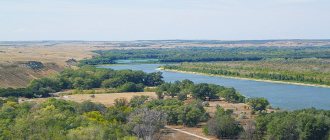
Lake Manych-Gudilo
- Coordinates: 46.299718, 42.830451.
In ancient times, a vast salt lake-estuary connected the Caspian and Black seas. It is believed that Manych received the name “Gudilo” because of the roar of the winds and waves. The reservoir is considered one of the largest not only in Russia, but also in Europe, although its surface area decreases every year. Currently, the length of Manych is more than 150 kilometers, which makes it similar to a small sea.
Manych is not fed by rivers and streams, so the lake gradually dries up due to the hot climate. The reservoir is always open to the sun, since there are no trees on the banks. Despite its impressive size, the lake is quite shallow, with an average depth of approximately 4 meters. In the warm season, the water quickly warms up, and vacationers flock to the sandy beaches of Manych.
The lake is very salty, so only the most persistent fish, such as needlefish and various types of smelt, live in its waters. In the middle of Manych two islands protrude from the water - Vodny and Ptichy. Herds of wild horses live on Vodny; mute swan, laughing gull, spoonbill and other birds nest on Ptichy.
Lake Gruzskoe
- Coordinates: 46.423020, 42.708298.
The healing mud of the lake in the Oryol region became known far beyond the region. Gruzskoe, like Manych-Gudilo, is a relict reservoir of marine origin, so its waters are salty and not suitable for drinking, but are excellent for other purposes.
The healing properties of the reservoir became known back in the 17th century, at which time a hospital appeared on its banks, where patients were treated with mud, kumis and brine - lake water with a very high concentration of salts. Today, the Manych tuberculosis sanatorium is open near the lake.
Lake Pelenkino
- Coordinates: 47.007438, 39.463871.
Another body of water, famous for its healing mud, can be seen in the Azov region. In the 18th century, the lands on which the lake is located belonged to the landowner Yakov Pelenkin. Even then, local serfs noticed that the mud from the reservoir healed various diseases, and told the master about this.
More than a hundred years later, at the beginning of the 20th century, scientists studied the mud and confirmed its beneficial properties. In 1920, a medical and health sanatorium called “Salt Lake” was built on the shore of Pelenkino. The institution closed long ago, but tourists still come to the reservoir to see its life-giving power and simply enjoy nature.
Don waterfalls
- Coordinates: 48.144167, 40.044444.
The waterfalls near the village of Uglerodovsky are also called Volchensky because of their proximity to the village of the same name. The largest of the waterfalls of this attraction reaches 10 meters in height and has the romantic name “Two Tears”. You can find the most reviews about it online.
A smaller waterfall, called "Spits", is located on the opposite side of the Zamchalovsky quarry. The water brothers are not alike, each has its own character and its own “zest”. One stream flows steadily down the slope, the second noisily falls onto a pile of stones and scatters in a heap of splashes.
Interesting places to stay in the Rostov region
Several attractions in the Rostov region deserve special mention. Most of these places are worth visiting in the warm season.
Pavlo-Ochakovskaya Spit
- Coordinates: 47.031189, 39.099101.
The Pavlo-Ochakovskaya Spit in the Taganrog Bay is an excellent place for a family vacation. Pleasant climate, warm Azov Sea, clean sandy beach - everything you need for swimming and sunbathing. The sea gives a light breeze, and steppe grasses fill the air with a delightful fragrance.
The descent to the depths is gentle, with virtually no sharp cliffs; the shore is quite shallow, so the bay is suitable for swimming with children. The bay attracts lovers of water sports, in particular windsurfing. For those who want to relax comfortably on the spit, recreation centers have been built.
Beglitsky Spit
- Coordinates: 47.125554, 38.579487.
The picturesque sand and shell spit in the Taganrog Bay is not as popular among tourists as other spits, but is valued among lovers of sports and recreation away from civilization. Visitors often set up entire tent camps on the shore, take mud baths from the bottom silt, swim in the sea at high tide and play sports. Thanks to the open terrain and strong winds, the spit is suitable for hang gliding and paragliding.
The nature of the braid is also interesting. More than 140 species of plants grow on the coast, seagulls and wild ducks nest. Rare mammals go to water in small freshwater lakes not far from the shore. In the hot summer, shallow reservoirs dry up and fill with water again in the fall. On the spit there are traces of human activity: the ruins of fish farm buildings from the times of the USSR and an old lighthouse.
Tulip Peninsula
- Coordinates: 46.885556, 42.029167.
An ordinary peninsula on the Manych River in spring turns into the most romantic place in the Rostov region. At the end of April, a multi-colored sea of wild tulips covers the ground, the wind sways waves of bright petals. Red, yellow, pink, white and even the rarest black flowers fill the air with a dizzying aroma.
Employees of the local nature reserve strictly monitor order so that tourists do not pick flowers or dismantle the luxurious meadow for bouquets. Feather grass, tartar grass, sweet clover, irises and other beautiful flowers and herbs also grow in the river valley. Every year near Manych the festival “Glorified Steppe” is held, dedicated to the nature of the steppe and the tulip peninsula.
Vodny Island
- Coordinates: 46.476263, 42.496709.
In the center of Lake Manych-Gudilo there is an unusual island, famous for its large population of wild horses. Its length is 12 km and its width reaches 4 km. It is still not known how wild animals got to the island in the middle of a salty reservoir. The Manych mustangs are looked after by the staff of the Rostovsky Nature Reserve; it is they who provide the animals with fresh water, which is not available on Manych.
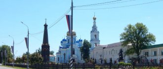
The city of Shakhty, Rostov region - attractions
The peculiarity of Shakhty is that there are several rivers and reservoirs here. I recommend visiting the following attractions:
- local history museum , located in the city center;
- a monument in honor of the 40th anniversary of Victory in the Second World War on the square of the same name;
- Alexander Park of the 19th century with the Alley of Memory of Heroes (WWII) and the Eternal Flame at the Mass Grave;
- Monument to Russian Emperor Alexander II.
monument in honor of the 40th anniversary of Victory in the Second World War
Churches in Shakhty
- Mikhailo-Arkhangelskaya;
- Intercession of the Blessed Virgin Mary;
- Holy Trinity;
- Church of St. Nicholas.
Where else is it worth going in the Rostov region
The region has many caves, springs and relict trees recognized as natural monuments. Certain natural objects deserve special attention.
Avilova Cave
- Address: Avilova Gora.
The cave in the Avila Mountains is a hard-to-reach place with an interesting history. The underground passage was carved by hand under the very top of the rocky mountain. Three centuries ago, during the time of Emperor Peter the Great, the monk Avil, or Vavil, settled in the cave. Tradition says that the hermit previously escaped in a cave near the village of Rygin, but for some reason he moved to a mountain near the shore of Kalitva and spent 20 years here in fasting and prayer.
For his spiritual exploits, Avil acquired the gift of clairvoyance; many believers came to the elder for advice, until a severe flood forced him to leave the cave. History is silent about the further fate of the monk. Today, Avilova Cave has become a popular tourist attraction. It is better to get there under the guidance of an experienced guide: the path leading to the mysterious passage is very narrow and is located at the edge of the cliff.
Veshensky oak
- Coordinates: 49.671181, 41.709682.
A 25-meter giant oak grows eight kilometers from the famous village of Veshenskaya, the small homeland of the writer M.A. Sholokhov, glorified in his novel “Quiet Don”. The tree has two trunks of almost equal height and diameter.
It is believed that the age of the “old man” has long exceeded four centuries, which means he dates back to the times of Ivan the Terrible. According to legend, the oak tree was planted by the Tatar Khan near a treasure cache, but for many years no one discovered the treasure.