| Chita, view from Titovskaya Sopka, beginning. 2010s Photo by Viktor Borisov |
Chita
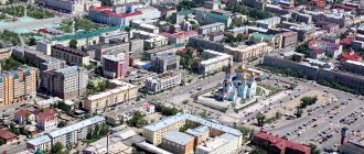
, a city in Russia, the administrative center of the Trans-Baikal Territory, the cathedral city of the Chita diocese. Located in the Chitino-Ingodinskaya depression and on the slopes of the Yablonovy (from the west) and Chersky (from the east) ridges, at the confluence of the river. Chita in the district Ingoda, 6198 km east of Moscow. Large transport hub, railway. station, highway junction, airport. Population - 335,760 people (January 1, 2014) [1]
- On the map: Yandex.Map, Google map
The Mongoloid population lived on the territory of the city, starting from the Old Stone Age. In the Middle Ages, the Tungus lived here. At the end of October 1653, after an unsuccessful attempt at rafting along the river. Ingoda by the Cossacks of Peter Beketov at the mouth of the river. A winter hut was established in Chita [2]. Beketov sent a report to Yeniseisk: “And in Zimovye there is a sovereign’s barn, and three Cossack huts.
And in Zimovye and near Zimovye he ordered a fortress to be built. And he ordered the sovereign’s treasury to demolish the anbar” [3]. The first permanent settlement began to be called a raft (shown on N. Witsen’s map of Siberia in 1687), since rafts, planks, and later boats and barges were built here. In 1688 (1689), the Nerchinsk Cossack K. Yudin wrote “from the Chita River of the new settlement of the plot” to Ambassador F.A. Golovin about accepting grain reserves. The rapid development and settlement of the raft was facilitated by its advantageous position on the high road, the waterway to Eastern Transbaikalia and the Amur, to the Pacific Ocean. At the turn of the 17th - 18th centuries, in the vicinity of Chita, along the eastern slope of the Yablonovy Range, Buryats settled, having migrated from the Khorinsky steppes (the valley of the Uda River). Since the end of the 17th century, the village has been known successively as the Chitinskoye raft, Chitinskaya Sloboda, Chitinsky fort, Chitinskoye village, Chitinsk.
In 1726 a postal station was established. According to the revision of 1762, in Chita (without villages) there were 6 families of Cossacks, 14 families of commoners and 4 families of peasants, for a total of 73 inhabitants. In 1764 - 1765, the peasant population was assigned to the Nerchinsk silver smelter and included in the Gorodishchenskaya volost. In 1798, the fort came under the jurisdiction of the Nerchinsk Mining and Factory Administration; the main occupation of the population was supplying bread and burning charcoal for the Shilkino silver smelting plant.
Volost center. Decembrists
In 1823, Chita became the center of the Chita volost.
In 1827 - 1830, the Decembrists served hard labor here. The first plan of Chita was drawn up in 1830 by the Decembrist P.I. Falenberg. The development of Chita as a city was greatly facilitated by the Decembrist Dmitry Zavalishin. After the amnesty in 1839, he remained in a settlement in Chita and launched educational activities. Through his efforts, schools were opened for children of “every rank and class.” Using his own funds, he supplied schools with teaching aids and worked as a teacher himself. He passed on his experience to local residents in cultivating the land, selecting seeds, and growing crops unknown in Siberia.
Regional center. Development of the city in the 19th - early 20th centuries.
According to the proposal of the Governor-General of Eastern Siberia N.N. Muravyov-Amursky, by decree of Emperor Nicholas I of July 11, 1851, Chita became the center of the Transbaikal region of the Russian Empire, as well as the center of the Transbaikal Cossack army. In the 1850s, Amur expeditions began from Chita. In 1859, the Mariinsky Women's Orphanage was opened. In 1864 - 1865, male and female boarding schools and a parish school were opened, which were later transformed into a city school. In 1865, the publication of the newspaper “Zabaikalsky Regional Gazette” began. In 1875, the first elections to the Chita City Duma were held, from which the Chita City Council was formed. In 1884, the Chita men's gymnasium was opened, in 1888 - the state chamber, in 1890 - a meteorological station, in 1893 - the Chita 1st women's gymnasium, in 1894 - a vocational school, a branch of the Amur department of the IRGO, in 1895 - a local history museum, a city library. Thanks to the merchants, tea, rice and sugar were imported from Kyakhta to Chita, nails came from the Urals, Rhine wines from Hamburg, and postage paper from America. In appearance, Chita more closely resembled not a regional center, but a large village built up with monotonous wooden houses that stood on poorly lit streets covered with sand, where livestock roamed freely. The largest buildings are the military assembly, the governor's house, the Eastern Compound hotel and several churches.
| Chita, general view, con. XIX - early XX centuries |
The end of the 19th - beginning of the century was marked by active construction.
In connection with the construction of the Trans-Baikal Railway in Chita, the construction of the Chita-1 station began in 1895, the Chita Main Railway Workshops in 1898, and the Chita-2 railway station in 1899. The first train arrived in Chita from the east on December 22, 1899. In 1896, a city telephone exchange was opened. In 1900, the Chita Teachers' Seminary was opened. In 1902, the fur coat factory of L.A. Soloboev began production, later the sheepskin and fur factory, and the sheepskin and fur factory. In 1894, the 1st city hospital was opened. In 1905, there were 7 general educational institutions, 1 special, 11 lower, 1 Sunday school; 3 banks, sawmills, brewery, brick factories. In 1906, the power plant began operating. At the beginning of the century, the city had such suburbs as Ostrov, Sloboda (Forge Rows), Terebilovka (behind the Archangel Michael Church), New Places and one suburb - Far Station (the territory of Chita-1). In 1907, there were 44 streets, which mostly bore names related to the history of development and geography of Siberia and the Far East. In the vicinity of Chita on the banks of the river. Ingoda, on the eastern slope of Titovskaya Sopka, there was the village of Titovo. In the future, she, as well as the village. Kashtak and s. Kenon entered the city limits. Since 1907, with the beginning of the exploitation of the Chernovsky brown coal deposit, the Chernovsky Mine Administration operated, around which the settlements of Chernovsky Mines were formed, which became part of Chita in 1941. In the 1920s, the area of the city increased with the inclusion of the village of Chita. Peschanka and village Antipikha.
Since the 1830s, the Chita prison operated as a transit prison. There were many political exiles living in the city. During the Russian-Japanese War of 1904-1905, Chita was a rear city where large military warehouses and hospitals were located. In addition, gymnasium buildings were transferred to hospitals. The Port Arthur gymnasium was evacuated to Chita. In 1905-1906, Chita was gripped by revolutionary unrest, and various political parties were active. In October 1905, many enterprises and institutions joined the All-Russian October political strike. From November 22, 1905 to January 22, 1906, power in Chita actually passed to the Soviets of Workers' Deputies and the Soviets of Soldiers' and Cossacks' Deputies, and the so-called "Chita Republic" arose. On January 22, 1906, a detachment of General P.K. entered the city with the aim of suppressing revolutionary uprisings. Rennenkampf, and then General A.M. Meller-Zakomelsky.
During the First World War, there were prisoners of war of the German, Austro-Hungarian and Turkish armies in the city and at nearby stations.
Revolution and civil war
After the February Revolution of 1917, dual power arose in Chita. On March 4, 1917, the Chita Council of Workers' Deputies and the Chita Council of Soldiers' Deputies were elected. On March 5, 1917, a meeting of representatives of political parties and public organizations elected the Trans-Baikal Committee of Public Security (KOB), the power body of the Provisional Government, which in October 1917 refused to recognize the Soviet power that had won in Petrograd. On December 31, 1917, the People's Council was created to replace the KOB. The Chita City Duma remained the local government body. On February 16, 1918, Soviet power was established in Chita. On April 5, 1918, the Chita Council dissolved the Duma and transferred its functions to the Municipal Economy Council headed by I.V. Reznikov.
On August 26, 1918, units of the Provisional Siberian Government entered Chita, and a few days later the troops of the Japanese Imperial Army and the Special Manchurian Detachment under the command of Ataman G.M. Semenov. As a result, the Transbaikal white statehood was established in the city.
On October 22, 1920, units of the Amur Front of the Far Eastern Republic (FER) entered the city; until 1922, Chita was the capital of the republic. In 1921, the first higher educational institution in the region, the State Institute of Public Education, was opened (in 1923 it was transferred to Vladivostok).
During the years of Soviet power
In 1923 - 1926, Chita was the center of the Trans-Baikal province of the Far Eastern Territory, in 1926 - 1930 - a district city of the Far Eastern Territory, in April - December 1934 - the center of the Chita region as part of the East Siberian Territory, since 1937 - the center of the Chita region.
Since 1923, most of the streets in the city center were named after revolutionaries, participants in the Civil War, Soviet and party leaders. Atamanskaya Square was also renamed, which became Freedom Square, Novosobornaya Square - Lenin Square, Zhukovsky Park was named Trade Union Park, and later the park of the District House of the Red Army. Since the 1920s, repressions began against the old intelligentsia, the clergy, and participants in the White movement. In 1937 - 1938, repressions became widespread against all segments of the population, including the city leadership. The executed Chita residents were secretly buried in the vicinity of Chita in the forest outside the village. Kashtak.
In the 1930s, a flour mill, a bakery, a cereal factory, a city refrigerator, a meat processing plant, an elevator and a mill, and an airport airfield were built; an automobile school, a flying club and a communications school Osoaviakhim (DOSAAF) were opened, preparing young people for service in the Red Army. In 1933, the first air line Chita - Harbin - Vladivostok - Tokyo was opened. In 1934, the first radio broadcasting station was built. In 1938, the Chita State Pedagogical Institute was opened.
In 1935, Chita became the center of the Trans-Baikal Military District, and in 1940 - the Trans-Baikal Border District. In 1939, Chita hospitals received wounded in battles with the Japanese on the Khalkhin Gol River in Mongolia.
During the Great Patriotic War, thousands of Chita residents were drafted into the army. Chita's position was determined by the fact that it was located deep in the rear and at the same time in close proximity to Manchuria, at the forefront of a possible attack from the Japanese Kwantung Army. Since September 15, 1941, the headquarters of the Transbaikal Front, created on the basis of the Transbaikal Military District, was located in Chita. Due to the real threat from Japan, large enterprises from the western regions of the country were not evacuated to the city. The city's enterprises produced products needed by the front. Factory No. 117 was created on the basis of mechanical workshops, producing up to one hundred types of aircraft parts. The Chita PVRZ has mastered the production of hand grenades and flamethrowers, a sheepskin and fur factory has mastered the production of military-style short fur coats, a distillery has mastered the production of combustible mixtures, etc. Evacuation hospitals were located in the city. The Institute of Epidemiology, Microbiology and Hygiene, which produced therapeutic and diagnostic bacterial preparations, provided great assistance to practical medicine during the war years. In August 1945, Chita was declared a front-line city. At the military resort of Molokovka (now within the boundaries of Chita), there was the headquarters of the High Command in the Far East, headed by Marshal A.M. Vasilevsky. Until 1949, there were Japanese prisoners of war in the city who worked on the construction of the Trans-Baikal Railway administration buildings, a number of residential buildings and other facilities.
In 1946, a technical school for mechanization and electrification of agriculture, a cooperative technical school was opened, in 1949 - a forestry technical school, in 1951 - a construction school, in 1953 - a medical institute, a railway transport technical school, in 1966 - a general technical faculty of the Irkutsk Polytechnic Institute. Since the early 1960s, the city began paving streets and large-scale construction, first of individual five-story buildings, then of residential multi-story microdistricts. In 1963, local television began to operate, and in 1967, the space television system began operating. In the second half of the century, a machine-building plant, a reinforced concrete products plant, a commercial equipment plant, a machine-tool plant, a worsted and cloth plant, a furniture woodworking plant, food factories, a sheepskin and fur factory, a clothing factory, CHPP-1, CHPP-2 operated in Chita. In the 1960s and 1970s, the city's transport system developed. In 1965, the city boundary expanded to include the village. Ivanovka and village Zastepe. In the 1970s, an asphalt road connected Chita with Lake Arakhley, one of the best recreation areas for city residents.
In 1972, Chita was awarded the Order of the October Revolution for the great successes achieved by the city's workers in economic and cultural construction, and in commemoration of revolutionary merits.
In the 1970-1980s, a network of secondary schools, kindergartens, and country pioneer camps developed. Healthcare and socio-cultural facilities were built. In 1978, a branch of the Novosibirsk Institute of Soviet Cooperative Trade was organized, in 1979 - a branch of the Irkutsk State Agricultural Academy, in 1985 - the Irkutsk Institute of National Economy.
In 1990, by a resolution of the board of the Ministry of Culture of the RSFSR, the board of the State Construction Committee of the RSFSR and the presidium of the Central Council of VOOPIiK, Chita was included in the list of historical populated places of the RSFSR. In the same year, the village was included in Chita. Zykovo, village Lapochkin's pad.
At the turn of the XX-XXI centuries.
In the 1990s, as part of the nationwide crisis changes, there was a sharp decline in production, the closure of a number of enterprises, a decline in the standard of living of the population, and an increase in social tension. The budgetary sector experienced significant difficulties, and social protests took place. At the end of the 1990s, the situation stabilized, and at the beginning of the 21st century, positive changes emerged. Construction has expanded in the city, including on individual projects, landscaping has intensified, foreign economic relations have strengthened, and trade has developed. Chita became a laureate of the national award “For worthy deeds - Grateful Russia”; in October 2005, at the IV All-Russian competition for the economic development of Russia “Golden Ruble”, it became the winner in the Siberian Federal District in the category “Best city in the Russian Federation in terms of economic indicators”.
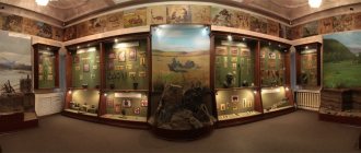
In the early 2000s, the city had 10 higher educational institutions, 12 secondary specialized educational institutions, 10 vocational schools, 61 schools, 5 research institutes, the Transbaikal branch of the Russian Geographical Society, the Chita branch of the All-Russian Mineralogical Society of the Russian Academy of Sciences, etc.; there were 24 museums of various profiles and departmental subordination, three professional theaters, and the Transbaikalia concert and theater complex; There was an equestrian sports center, an ice sports palace with artificial ice, a biathlon center, and other sports facilities.
Statistics
- 1715 - 20 mounted Cossacks with two foremen, who were in charge of the “clerk Nerchinsky, 4th article, boyar son Leonty Shestyakov” [4]
- 1762 - 6 families of Cossacks, 14 families of commoners and 4 families of peasants, a total of 73 inhabitants [5]
- beginning 1820s - 300 inhabitants and 26 houses [5]
- 1851 - 659 people [5]
- 1863 – 3140 people [5]
- 1897 - 11,848 people [5]
- 1905 - 42,735 people [5]
- 1910 - 68,211 people [5]
- 1923 - 60,033 people [5]
- 1948 - 138 thousand people [5]
- 1970 - 242 thousand people [5]
- 1999 - 312 thousand people [5]
- 2002 - 316,643 people [5]
What is she like, Chita?
Photo: Anatoly YAKIMOV
Chita ranks 129th in the security rankings
According to the website gradoteka.ru, the capital of Transbaikalia took the last 129th place in the safety rating in 2013. And at the same time, State Duma deputies decided to move our region to a new time zone - Irkutsk (Moscow +5 hours), to which we will move from October 26. In this case, the amount of sunlight will be halved. In Chita, 39,086 crimes per 1000 people were registered.
The first place in the safety ranking was taken by the city of Grozny, where in 2013 4.03 crimes were committed per 1,000 people. Next come: Khasavyurt (Republic of Dagestan, 4.29 crimes per 1000 people); Kaspiysk (Republic of Dagestan, 4.68 crimes per 1000 people).
Moscow ranks 56th in the ranking. In the Russian capital, 15.05 crimes per 1,000 people were registered last year. St. Petersburg ranks 22nd with 11.23 crimes per 1,000 people. The capital of Siberia, Novosibirsk, took 104th place in the ranking with an indicator of 21.49 crimes per 1000 people. Krasnoyarsk ranks 113th with an indicator of 22.96 crimes per 1000 people. Angarsk and Irkutsk occupy 121 and 128 places, respectively, with a rating of 24.73 and 32.55 crimes per 1000 people.
In the population density ranking, Chita ranks 154 out of 165.
Rating of cities by population density. Population density is the number of inhabitants per 1 km2 of territory. The average world population density as of 2013 is 52 people per 1 km2. The population density in Russia as of January 1, 2014 is 8.4 people per km2.
The first three places are occupied by the Moscow region cities of Odintsovo, Balashikha and Zheleznodorozhny, in which there are 7033.12 per 1 km2; 6077.89 and 5882.39 people respectively.
Moscow takes 7th place. 4822.1 people live here per 1 km2. In St. Petersburg, which ranks 16th, 3,566.32 people live per 1 km2. In Novosibirsk and Krasnoyarsk (27th and 36th places in the ranking) there are 3079.19 and 3735.07 people per 1 km2. Irkutsk and Ulan-Ude occupy 63rd and 128th places. There are 2189.35 and 1155.67 people living there per 1 km2.
The last place in the ranking is occupied by the city of Berezniki, Perm Territory. 349.56 people live here per 1 km2.
Chita is the 11th largest city in Russia
Rating of cities by area. The area of a city is defined as the area expressed in square kilometers within the city limits. The area of the city is indicated in the general plan - a document on the basis of which planning, development, reconstruction and other types of urban development of the territory are carried out.
In the ranking of city areas, first place is given to Moscow. The capital of Russia covers an area of 2511 km2. In second place is the Northern capital - St. Petersburg, which is located on an area of 1439 km2. But in third place, unexpectedly, is the Ural city of Perm, which occupies an area of 799.68 km2.
2 lines below Chita, which is located on an area of 534 km2, is the city of Novosibirsk - 13th place (502.7 km2). Ulan-Ude and Irkutsk occupy 27 and 48 places (365 and 279.98 km2), respectively. The last place in the ranking by city size is occupied by Odintsovo near Moscow, which occupies an area of 19.6 km2.
Who has more men or women?
Did you know that the largest percentage of women lives not in Ivanovo, but in Veliky Novgorod - 56.64%. Second place is occupied by Yaroslavl - 56.12, third - Nizhny Novgorod - 56.06%.
Chita occupies 81st place in this ranking - 53.86% and over the past year has moved up three positions. Irkutsk ranks 26th – 55.33%; Krasnoyarsk – 59th place – 54.65%. Moscow and St. Petersburg occupy 42 and 79 places, respectively – 54.9% and 53.9%. The last line - 110th place - is occupied by Nalchik - 44.58%.
Accordingly, the largest percentage of men lives in Nalchik - 55.42%. In second place among male cities is Maykop - 55.37%, and in third place is Tyumen - 53.48%.
Chita occupies 30th position in this ranking - 46.15%. Moscow – 32nd place – 46.1%; Krasnoyarsk – 52nd place (45.35%); St. Petersburg – 63rd place (45.1%); Irkutsk – 85th place (44.57%). Veliky Novgorod, which took first place in the women's ranking, was in last, 110th place (43.36%) in the men's ranking.
Chita is a city of young people!
Rating of cities by percentage of youth from the total number of citizens. Youth includes city residents aged from 18 to 30 years. The share of young people depends on the dynamics of the birth rate and the age structure of the population.
In this ranking, Chita takes an honorable 4th place. 25.57% of young people live in the capital of Transbaikalia. Although a year earlier we were in third place.
The first place in the ranking of youth cities is occupied by Stavropol (28.69%). In second place is Yakutsk (26.95%), in third is Novocherkassk (26.60%), which a year earlier occupied 8th place in the ranking.
Irkutsk ranks 6th (24.98%) and has improved its position by 1 point over the year. But Krasnoyarsk moved from 5th place to 7th (24.77%). St. Petersburg ranks 55th (19.67%); Moscow – 85th place (18.01%). But in Rybinsk and Yaroslavl region it is 15.68%.
Working population. 18th place
In the ranking of cities by the share of the working-age population of the total number of citizens, Chita ranks 18th out of 106. 64.03% of Chita residents are able-bodied. This term refers to the totality of citizens who, according to their psychophysiological data, are capable of participating in the labor process. In Russia, the working population is considered to be women from 16 to 54 years old and men from 16 to 59 years old. The share of the working-age population depends on the dynamics of the birth rate and the age structure of the population.
The first place in this ranking is occupied by the city of Novy Urengoy, Yamalo-Nenets Autonomous Okrug. Here, 74.13% of the population is able-bodied. In second place is Norilsk, Krasnoyarsk Territory (71.75%). In third place is Noyabrsk, Yamalo-Nenets Autonomous Okrug (69.83%).
Krasnoyarsk in the ranking among working-age cities dropped from 11th to 12th place, 65.40%. But Irkutsk, on the contrary, rose three positions from 27th to 24th place. 63.22% of the working population live there. Moscow ranks 40th (61.96%). St. Petersburg is in 47th place (61.48%). The last, 106th place in the ranking is occupied by the city of Miass, Chelyabinsk region. 56.62% of the total population are able-bodied.
Attractiveness of the urban environment. Not happy
The rating of cities according to the urban environment attractiveness index is calculated based on 13 indicators of the condition and dynamics of the city’s development.
In this rating, the capital of Transbaikalia ranks 154 out of 165. The index of attractiveness of the urban environment in Chita is 24.38 points.
In first place is Moscow (59.34). In second place is St. Petersburg (40.19). In third place is Krasnodar (39.25).
Novosibirsk ranks 7th in the attractiveness index ranking (36.75); Krasnoyarsk – 32nd place (32.11); Irkutsk – 45th place (31.27); Angarsk – 61st place (29.89); Ulan-Ude – 104 (28.26).
The last place is occupied by the city of Prokopyevsk, Kemerovo region. There, the urban environment attractiveness index is 20.67 points.
Provision of housing for the population . Could have been better.
In the ranking of cities based on average living space per resident, Chita ranks 141 out of 159. Each Chita resident has 19.7 m2 of living space.
The first place in the ranking is occupied by the city of Grozny, which has 57.1 m2 per inhabitant. On the second - Vladikavkaz (32.5 m2), on the third - Khimki near Moscow (32 m2).
In St. Petersburg, which is located in 52nd place, each resident has 23.8 m2. Irkutsk – 88th place (22.3 m2); Novosibirsk – 97th place (22.1 m2); Krasnoyarsk – 103rd place (22 m2). Moscow ranks 146th in this ranking. Here there are 19.3 m2 for each resident.
In last, 159th place, is the city of Makhachkala - 12.1 m2.
Stability of development . 139th place
The rating of cities for stability of development is calculated through 32 indicators in the socio-economic and environmental spheres. Chita ranks 139th in this ranking. The development stability index is equal to 3 points.
The first place in the ranking is occupied by the Moscow region city of Krasnogorsk (10). In second place is Moscow (9.2); in third is Novy Urengoy (8.9).
St. Petersburg ranks 15th (7.8); Angarsk – 88 (5); Krasnoyarsk – 98 (4.9); Novosibirsk – 107 (4.7); Irkutsk – 106 (4.6); Ulan-Ude – 133 (3.4).
Prokopyevsk has the last place – 1 point.
Length of city streets . 45th place
This rating was calculated based on the length of all city streets. Chita ranks 45th in it. The length of Chita highways is 636 kilometers.
Moscow is in 1st place (5860 km); at 2 – St. Petersburg (3309.5 km), at 3 – Omsk (1910 km).
Novosibirsk occupies 10th position in the ranking (1425.6 km); Krasnoyarsk – 16 (1173 km); Ulan-Ude – 34 (758 km); Irkutsk – 38 (712 km).
The last place belongs to the city of Nizhnevartovsk, Khanty-Mansiysk Autonomous Okrug. Here the length of all streets is 124.5 kilometers.
The cost of 1 m 2 of housing is not too expensive for us yet
This rating was compiled based on the average cost of 1 m2 of living space. The capital of the Trans-Baikal Territory occupies 45th place in this ranking. On average in Chita, 1 m2 of living space costs 57,133 rubles.
The most expensive housing in Moscow. There, 1 m2 can be bought for 219,927 rubles. In second place is the city of Domodedovo near Moscow (118,181 rubles), in third place is the city of Khimki near Moscow (109,417 rubles).
St. Petersburg and Lipetsk shared 7-8 places (98,621 rubles); Krasnoyarsk is in 37th place (60,857 rubles); Novosibirsk – in 41st place (57,921 rubles); Irkutsk – in 42nd place (57,850 rubles); Ulan-Ude – in 67th place (52,070 rubles); Angarsk is in 123rd place (40,266 rubles).
The cheapest housing is 18,333 rubles per 1 m2 in the city of Novoshakhtinsk, Rostov region.
To be continued.
Program of events
Figure 3. Family competitions
Chita City Day in 2021, as before, is one of the most anticipated holidays in the capital of Transbaikalia. Residents and guests can expect an unforgettable experience and fun. Event organizers promise to organize mass celebrations to make it interesting for children and adults.
Procession of townspeople
The celebration of the city begins with a procession of labor collectives along the central streets, sporting events and musical performances. The celebration of the birthday of the beloved city is held not only on the Central Lenin Square, but also in other places:
- The Chita State Stable named after Khakimov hosts an agricultural fair, “Round Dance of Friendship” and national cuisine festivals. Competitions in equestrian sports.
- The Sports Palace hosts chapter cup competitions in mixed martial arts, karting, and swimming.
Performance for Chita's birthday in 2021
- At the Yunost stadium there is a sports festival “Green Marathon”.
- On Theater Square there is a youth festival of street dancing and cheerleading, and in the evening there is karaoke.
- In the Park of Culture, from the very morning there will be attractions for children and adults, cafes and stalls with souvenirs and delicacies.
Performance of children's groups on the square near the Drama Theater
Every year, festive events on City Day are held in almost all cultural and public places. Everywhere you can feel the atmosphere of fun and festivities, from the administration building to the local history museum or drama theater.
For those who for some reason were unable to enjoy the holiday and fun, all the main events will be broadcast on television: “Russia-1” + State Television and Radio Broadcasting Company “Chita” and the “Altes” channel.
The celebrations end with fireworks on Lenin Square. An example is a video recording from 2021.
Hymn
At the site of Chita's first date with the cool Ingoda, free Cossack legends sang our native city: In the river valleys, in the transparent blue On the slopes of the Chersky ridge... Preserve the greatness of Russia And prosper for centuries, Chita!
The ancestors founded the winter quarters, And the settlement was replaced by a fort, Along the Trans-Siberian Railway, Russia traveled to the east. The heroic spirit was extolled, And the power of the sovereign shield... Preserve the greatness of Russia And prosper for centuries, Chita!
For the benefit of the Motherland, the deeds of Vershi, talented people... Create, the capital of Transbaikalia, Siberia, pride and stronghold! A bold dream leads us to new victories through the elements: Preserve the greatness of Russia And prosper for centuries, Chita!
From the history of the city
The appearance of Chita is associated with the development of the vast expanses of Siberia by service people. Moving deeper into the Siberian expanses following the Cossacks, a variety of merchant and industrial people walked. The detachment of Peter Beketov in 1653 reached the river. Ingoda and laid out the winter quarters. This settlement was called Plotbishche, because the construction of rafts and later boats was carried out here. Having an advantageous geographical location, being at the intersection of land and waterways, the Plotby developed rapidly. In 1699, a fort appeared, which in 1706 received the name Chitinsky.
The future city owes its further development to the development of silver mines in the surrounding area at the beginning of the 17th century, called Nerchensky, and the construction of factories. From the written sources of the 18th century that have reached us, we can find out the population of Chita at that time. In 1762 it was 73 inhabitants. The shortage of labor was made up by using convict labor.
Over time, the fort began to belong to the Nerchensk Mining Administration. This left its mark on employment. Chita continued its industrial development thanks to the fact that its residents began to burn charcoal to smelt ore, supplying it to the Shilkinsky plant. Forestry and rafting of cargo along the river were also common occupations of the local population.
In the 20s In the 19th century, the city already had 300 inhabitants. Chita became the center of the Chita volost. The Decembrists, who were exiled here to hard labor, played an important role in the development of the city.
In the middle of the 19th century, the Transbaikal region was formed. The title of its main urban center was given to Chita, whose population began to grow rapidly. In 1863, three thousand residents already lived here.
Chita entered the 20th century as a developed industrial city in Siberia. A railway was built, many factories and factories were operating. The settlement became a major trading center in Transbaikalia. Houses and temples were built, a synagogue and a mosque operated, and a library appeared. The population of the city by 1910 was more than 68 thousand people.
After the October Revolution, the city was for some time the capital of the Far Eastern Republic. During the Second World War, Chita enterprises worked for the needs of the front. In 1945, the headquarters of the Commander-in-Chief in the Far East, Marshal Vasilevsky, was located here. Until 1949, Japanese prisoners of war worked in the city on the construction of various buildings.
The city's social infrastructure developed. Chita, whose population worked hard at industrial enterprises and in the social sphere, was awarded the Order of the October Revolution in 1972.
Chita in the 21st century
Today Chita is a developed industrial city. The construction of objects of various importance has expanded, new foreign policy ties have been established, and trade is developing. Chita (the city’s population is especially proud of this) became the laureate of the prestigious national award “For worthy deeds - Grateful Russia”, the winner of the fourth All-Russian competition “Golden Ruble” in its district.
There are universities, schools, vocational guidance colleges, and research institutes in the city. Chita, whose population has the opportunity to raise its cultural level, has a sufficient number of educational institutions. There are 24 museums, theaters, a circus, a philharmonic society, and a large concert complex. Festivals and competitions of various levels are regularly organized and held.
Coat of arms
The coat of arms of Chita is presented in the form of a French shield.
An eight-pointed scarlet and green palisade is depicted on a golden background. It points to the border with Mongolia and China. Above is a red buffalo head with silver eyes and tongue. It symbolizes agriculture.
The shield is topped with a gold tower crown with five teeth, surrounded by a gold laurel wreath on the hoop and entwined with a ribbon of the Order of the October Revolution (bottom and sides).
The artistic composition was adopted by the decision of the Duma of the city district. Chita" No. 177 dated November 15, 2007.
Flag
The flag of Chita is made in the form of a rectangular panel. The ratio of its sides is 2:3. It is divided into four elements. At the shaft there is a yellow isosceles triangle. It has a base that matches the width of the flag. Its height is equal to half the length of the canvas. The figure is adjacent to equal stripes (pali) of green, white and red. The last one is located at the bottom, the second one is in the center.
The artistic composition was approved on December 14, 2006 (decision No. 225).
City information
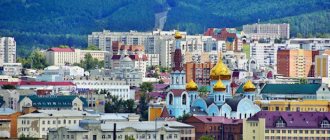
Chita is the administrative center of the district of the same name and the Trans-Baikal Territory of the Russian Federation. Located in Eastern Siberia. The economy is represented by enterprises of the energy generating, mechanical engineering, and food industries. There are trading and service companies operating.
Near the settlement there are federal highways: P258, P297, A166. The line of the Trans-Siberian Railway runs through. There are vocational educational institutions, universities and their branches. The population is more than 330 thousand people. The ecological situation poses a danger to the environment.