Characteristics of the city of Novotroitsk, Orenburg region
Novotroitsk is a city in the Orenburg region, located in its southern part on the border with Kazakhstan. The city is an important center of ferrous metallurgy in the Urals, so the history of its origin and development is directly related to the discovery of iron deposits:
- the beginning of the 20th century - several farmsteads were formed on the site of the city - Silnov, Akkermanovsky and Beloshapochny;
- 1920s - several families of Ukrainian immigrants found the settlement of Novotroitsk;
- 1929 - discovery of unique iron ore deposits containing chromium, nickel, titanium and manganese near it;
- 1939 – start of construction of the Orsk-Khalilovsky Metallurgical Plant;
- 1945 - the united villages of Novotroitsk and Akkermanovka receive city status;
- 1955 – the first cast iron was produced at the plant.
The population of Novotroitsk has a steady downward trend and amounts to 95 thousand people. Ethnic composition of the population: Russians 90%, Tatars 3%, Kazakhs 3%, Bashkirs 2%, Ukrainians 2%.
Possible reasons for the loss of residents
Novotroitsk belongs to the industrial cities of the Soviet “hardening”, which were formed and rapidly developed during the Soviet period. As the situation in the country changed, the need for heavy industries decreased, and the nature of economic activity also changed. This naturally led to socio-economic difficulties. There are quite a few similar cities in Russia, and there are some in the USA. The largest of them is Detroit. Adapting them to new conditions is a rather difficult task that requires a thoughtful and competent approach.
The deteriorating economic situation forces residents, especially young people, to migrate to more prosperous regions of the country, which leads not only to direct migration outflow, but also to a decrease in the birth rate, since mainly older generations remain, many of whose representatives continue to work in enterprises. All such cities are characterized by a convex curve of the number of inhabitants.
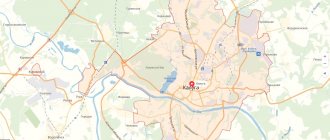
Novotroitsk on the map of Russia: geography, nature and climate
Novotroitsk on the map of Russia is located in the southern foothills of the Urals on the border with Kazakhstan. The distance to the regional center of Orenburg is 276 km. The Ural River flows in close proximity to the city, and in Novotroitsk itself there are the Izvestkovy Log and Maksai streams, and Lake Sazanye. The area around Novotroitsk is steppe, the average height of the city above sea level is 200 meters. Small floodplain forests grow along the banks of the Urals.
The climate of Novotroitsk is moderate, sharply continental, with large amplitudes of annual and daily temperatures. Winter in the city is frosty and snowy, with frequent snowstorms and snowstorms, lasting up to 5 months. Summer is hot and dry, with often recurring dry winds, and lasts approximately 4 months. The average temperature in January is -16, and in July – +21 degrees Celsius. Approximately 320 mm of precipitation falls annually, which is evenly distributed throughout the year.
Population[ | ]
| Population | ||||||||||
| 1939[6] | 1959[7] | 1962[6] | 1967[6] | 1970[8] | 1975[9] | 1976[10] | 1979[11] | 1982[12] | 1985[13] | 1986[10] |
| 3000 | ↗54 484 | ↗69 000 | ↗82 000 | ↗83 439 | ↗91 000 | →91 000 | ↗94 647 | ↗100 000 | ↗106 000 | ↘105 000 |
| 1987[14] | 1989[15] | 1990[16] | 1991[13] | 1992[13] | 1993[10] | 1994[10] | 1995[13] | 1996[13] | 1997[17] | 1998[13] |
| →105 000 | ↗106 084 | ↗107 000 | ↗108 000 | ↘107 000 | ↗108 000 | ↗109 000 | ↗110 000 | ↗111 000 | ↘110 000 | →110 000 |
| 1999[18] | 2000[19] | 2001[13] | 2002[20] | 2003[21] | 2004[22] | 2005[23] | 2006[24] | 2007[25] | 2008[26] | 2009[27] |
| ↘109 700 | ↘109 600 | →109 600 | ↘106 315 | ↘106 100 | ↘105 700 | ↘104 900 | ↘103 900 | ↘103 200 | ↘102 200 | ↘101 313 |
| 2010[28] | 2011[6] | 2012[29] | 2013[30] | 2014[31] | 2015[32] | 2016[33] | 2017[34] | 2018[35] | 2019[36] | 2020[37] |
| ↘98 173 | ↗98 200 | ↘96 546 | ↘95 095 | ↘93 578 | ↘91 640 | ↘89 905 | ↘88 216 | ↘86 474 | ↘84 897 | ↘83 647 |
| 2021[2] | ||||||||||
| ↘82 463 | ||||||||||
As of January 1, 2021, in terms of population, the city was in 199th place out of 1,116[38]cities of the Russian Federation[39].
Routes on the map of Novotroitsk. Transport infrastructure
The Orenburg–Orsk railway passes through Novotroitsk . From the Novotroitsk station, located on Sovetskaya Street, 1, trains depart in the directions Adler - Chelyabinsk, Orenburg - Yekaterinburg, Orsk - Moscow, as well as electric trains Orsk - Orenburg and Orsk - Kuvandyk.
The Novotroitsk bus station is currently not functioning; the nearest bus station is in the neighboring city of Orsk, the distance to which on the satellite map of Novotroitsk is 8 km to the east. From the Orsk bus station there are regular buses to Orenburg, Kuvandyk, Yasny, Adamovka, Magnitogorsk, Ufa and Novotroitsk. His address: Gagarin Square, 1A.
Novotroitsk also does not have its own airport. Orsk International Airport is located 37 km south of Novotroitsk and serves passenger air transportation to Orenburg, Moscow and Svetly.
The city's public transport is represented by 8 bus and 5 tram routes. Suburban buses also depart from Novotroitsk to Akkermanovka, Khabarnoye, Guberlya, Prigornoye and Novonikolsk. The fare on city bus routes is 15 rubles, and on tram routes – 10 rubles.
Notes[ | ]
- ↑ 1 2 3
Website of the City Administration of Novotroitsk.
Characteristics of the city (unspecified)
(inaccessible link). Access date: February 11, 2012. Archived November 3, 2012. - ↑ 123456
The permanent population of the Russian Federation by municipalities as of January 1, 2021 (Russian). Date accessed: April 27, 2021. Archived May 2, 2021. - ↑ 123
DB of the PMO of the Orenburg region. City of Novotroitsk - Order of the Government of the Russian Federation of July 29, 2014 No. 1398-r “On approval of the list of single-industry towns”
- Federal Law of 06/03/2011 No. 107-FZ “On the calculation of time”, Article 5 (undefined)
(June 3, 2011). - ↑ 1234
People's encyclopedia "My City". Novotroitsk - All-Union Population Census of 1959. The size of the urban population of the RSFSR, its territorial units, urban settlements and urban areas by gender (Russian). Demoscope Weekly. Access date: September 25, 2013. Archived April 28, 2013.
- All-Union Population Census of 1970 The size of the urban population of the RSFSR, its territorial units, urban settlements and urban areas by gender. (Russian). Demoscope Weekly. Access date: September 25, 2013. Archived April 28, 2013.
- Russian Statistical Yearbook, 1998
- ↑ 1 2 3 4
Russian statistical yearbook.
1994 (unspecified)
. Date accessed: May 18, 2021. Archived May 18, 2016. - All-Union Population Census of 1979 The size of the urban population of the RSFSR, its territorial units, urban settlements and urban areas by gender. (Russian). Demoscope Weekly. Access date: September 25, 2013. Archived April 28, 2013.
- National Economy of the USSR 1922-1982 (Anniversary Statistical Yearbook)
- ↑ 1 2 3 4 5 6 7
Russian statistical yearbook.
Goskomstat, Moscow, 2001 (unspecified)
. Access date: May 12, 2015. Archived May 12, 2015. - National economy of the USSR for 70 years: anniversary statistical yearbook: [arch. June 28, 2016] / USSR State Committee on Statistics. - Moscow: Finance and Statistics, 1987. - 766 p.
- All-Union population census of 1989. Urban population (undefined)
. Archived from the original on August 22, 2011. - Russian statistical yearbook. 2002: Statistic collection. / Goskomstat of Russia. – M.: Goskomstat of Russia, 2002. – 690 p. - In Russian. language – ISBN 5-89476-123-9: 539.00.
- Russian statistical yearbook. 1997 (unspecified)
. Retrieved May 22, 2021. Archived May 22, 2016. - Russian statistical yearbook. 1999 (unspecified)
. Date accessed: June 14, 2021. Archived June 14, 2016. - Russian statistical yearbook. 2000 (unspecified)
. Date accessed: June 13, 2021. Archived June 13, 2016. - All-Russian population census 2002. Volume. 1, table 4. Population of Russia, federal districts, constituent entities of the Russian Federation, districts, urban settlements, rural settlements - regional centers and rural settlements with a population of 3 thousand or more (unspecified)
. Archived from the original on February 3, 2012. - Cities and districts of the Orenburg region. Orenburg. Printing house of Orenburgstat. 2004. - 283 p. (undefined)
. Retrieved May 3, 2015. Archived May 3, 2015. - Russian statistical yearbook. 2004 (unspecified)
. Date accessed: June 9, 2021. Archived June 9, 2016. - Russian statistical yearbook, 2005 (unspecified)
. Date accessed: May 9, 2021. Archived May 9, 2021. - Russian statistical yearbook, 2006 (unspecified)
. Retrieved May 10, 2021. Archived May 10, 2016. - Russian statistical yearbook, 2007 (unspecified)
. Retrieved May 11, 2021. Archived May 11, 2016. - Russian statistical yearbook, 2008 (unspecified)
. Date accessed: May 12, 2021. Archived May 12, 2016. - The size of the permanent population of the Russian Federation by cities, urban-type settlements and regions as of January 1, 2009 (unspecified)
. Retrieved January 2, 2014. Archived January 2, 2014. - All-Russian population census 2010. Number and distribution of the population of the Orenburg region (unspecified)
. Retrieved June 5, 2014. Archived June 5, 2014. - Population of the Russian Federation by municipalities. Table 35. Estimated resident population as of January 1, 2012 (unspecified)
. Retrieved May 31, 2014. Archived May 31, 2014. - Population of the Russian Federation by municipalities as of January 1, 2013. - M.: Federal State Statistics Service Rosstat, 2013. - 528 p. (Table 33. Population of urban districts, municipal districts, urban and rural settlements, urban settlements, rural settlements) (undefined)
. Retrieved November 16, 2013. Archived November 16, 2013. - Table 33. Population of the Russian Federation by municipalities as of January 1, 2014 (unspecified)
. Access date: August 2, 2014. Archived August 2, 2014. - Population of the Russian Federation by municipalities as of January 1, 2015 (unspecified)
. Access date: August 6, 2015. Archived August 6, 2015. - Population of the Russian Federation by municipalities as of January 1, 2021 (Russian) (October 5, 2018). Date accessed: May 15, 2021. Archived May 8, 2021.
- Population of the Russian Federation by municipalities as of January 1, 2021 (Russian) (July 31, 2017). Retrieved July 31, 2021. Archived July 31, 2021.
- Population of the Russian Federation by municipalities as of January 1, 2021 (Russian). Retrieved July 25, 2018. Archived July 26, 2021.
- Population of the Russian Federation by municipalities as of January 1, 2021 (Russian). Date accessed: July 31, 2019. Archived May 2, 2021.
- Population of the Russian Federation by municipalities as of January 1, 2021 (Russian). Date accessed: October 17, 2021. Archived October 17, 2021.
- taking into account the cities of Crimea
- https://rosstat.gov.ru/storage/mediabank/bul_Chislen_nasel_MO-01-01-2021.rar Population of the Russian Federation by municipalities as of January 1, 2021 (1.85 Mb, 07/30/2021)
- JSC "Ural Steel" (unspecified)
.
industrialselkhoz.rf
. - FC Nosta-Novotroitsk ceased to exist, but the city decided not to leave Novotroitsk without football. Now young men born in 1990-1991 will play in FC Nosta (on a voluntary basis for now) (unspecified)
. Access date: January 28, 2010.
Sights of the city of Novotroitsk
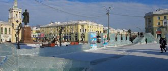
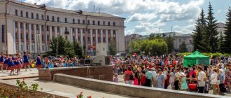
- The Palace of Culture of Metallurgists is the pride of Novotroitsk. Here you can see the Tatar-Bashkir ensemble and show ballet, listen to the veterans' choir and children's pop songs. The building was built in 1963 in the Greco-Roman style. Attraction address: Sovetskaya street, 30.
- Monument to the Cossacks who died for Russia , erected on the highway between Novotroitsk and Orsk. It is made in the form of an Orthodox cross, at the base of which are two St. George crosses - a symbol of honor, valor and courage of the defenders of Russia.
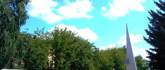
- Peter and Paul Cathedral , built in 2005 in the style of cathedrals of the 15th and 16th centuries. It offers a beautiful view of the surrounding mountains. Located on Sovetskaya street, 127.
- Museum of History and Local Lore , which displays more than 40 thousand exhibits: Tula samovars, military uniforms of the Russian army, pre-revolutionary postcards and archaeological finds of the region. The museum is located on Sovetskaya Street, 82.
- An interesting attraction is the monument called “Eternally Alive” . Nearby there is a site with an eternal flame.
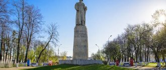
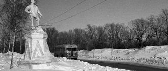
- Monument dedicated to the first builders of the city . It is located on Cheremnykh Street.
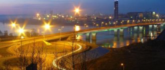
- An excellent natural place for outdoor recreation is the coast of the Ural River .
Local government[ | ]
On October 26, 2001, Andrei Aleksandrovich Velikanov took office as mayor of the city. In 2005, A. A. Velikanov was re-elected for a second term.
On October 10, 2010, elections for the mayor and deputies of the city council were held in the city. On September 13, 2015, a new convocation of deputies of the city of Novotroitsk was elected.
| Candidate | Subject of nomination | Number of votes | % |
| Chizhova Galina Dmitrievna | United Russia | 12640 | 65,88 % |
| Barsukov Alexander Petrovich | Just Russia | 3196 | 16,66 % |
| Wolfson Felix Davydovich | self-nomination | 2200 | 11,47 % |
| District | Candidate | Subject of nomination | % |
| 1 | Antonov Mikhail Vasilievich | Communist Party of the Russian Federation | 34,23 % |
| 2 | Sharikov Evgeniy Viktorovich | United Russia | 57,97 % |
| 3 | Kryzhanovsky Konstantin Ivanovich | United Russia | 64,24 % |
| 4 | Mezentsev Andrey Anatolievich | United Russia | 61,25 % |
| 5 | Ivanov Alexander Anatolievich | Communist Party of the Russian Federation | 60,60 % |
| 6 | Matveev Maxim Dmitrievich | Communist Party of the Russian Federation | 39,73 % |
| 7 | Chernigova Svetlana Anatolevna | United Russia | 36,69 % |
| 8 | Meisinger Dmitry Teodorovich | Communist Party of the Russian Federation | 42,26 % |
| 9 | Kazaev Anton Borisovich | United Russia | 64,71 % |
| 10 | Denisov Viktor Vasilievich | self-nomination | 39,62 % |
| 11 | Nazarova Elena Vasilievna | United Russia | 55,47 % |
| 12 | Kotova Larisa Anatolyevna | United Russia | 54,42 % |
| 13 | Kalinushkin Viktor Alekseevich | United Russia | 68,44 % |
| 14 | Sudakov Boris Alexandrovich | United Russia | 36,91 % |
| 15 | Skobarin Konstantin Vladimirovich | Communist Party of the Russian Federation | 47,36 % |
| 16 | Zhukov Konstantin Vasilievich | United Russia | 32,52 % |
| 17 | Uvarova Tatyana Vitalievna | United Russia | 63,88 % |
| 18 | Menshikov Denis Anatolievich | United Russia | 74,13 % |
| 19 | Nekrasov Vladimir Gennadievich | United Russia | 74,31 % |
| 20 | Kartamyshev Alexey Gennadievich | United Russia | 65,69 % |
| 21 | Kaverin Sergey Nikolaevich | United Russia | 68,74 % |
| 22 | Shindyaev Arkady Vladimirovich | United Russia | 70,68 % |
| 23 | Korotych Alexey Sergeevich | United Russia | 58,98 % |
| 24 | Krat Olga Vladimirovna | United Russia | 40,88 % |
| 25 | Ivanov Alexander Gennadievich | United Russia | 33,06 % |
The United Russia faction includes 20 deputies, the Communist Party of the Russian Federation faction includes 5. In 2021, Konstantin Skobarin became an assistant to Sergei Katasonov and therefore he became a member of the LDPR. As a result, United Russia retained 20 deputies, the Communist Party of the Russian Federation - 4, LDPR - 1.
Main streets of Novotroitsk
- st. Sovetskaya is the most important and longest highway in Novotroitsk, starting from Zavodskaya Street on the eastern outskirts of the city and ending in its western part. On this street there is a train station, a park and Metallurgists Square, the Metallurg stadium, city hospital No. 2, a wedding palace and the city administration.
- st. Mira is a street in the Western district of the city, starting from the railway line and ending near the Izvestkovy Log stream. Lyceum No. 1 and the Molodezhny cinema have its name in the address, and in close proximity to it there is a hospital town. The map of Novotroitsk with streets and houses shows that at the beginning of the street. Mira passes through a multi-family residential development, and then through the private sector.
- st. Frunze is a short (less than 1 km) street on the southern outskirts of Novotroitsk, on the left side of which there are multi-storey residential buildings, and on the right side there are mainly educational institutions: Yagodka kindergarten, vocational school No. 34, Novotroitsk branch of MISiS University and Alley Forever Alive.
- st. Zheleznodorozhnaya , running along the railway track through industrial enterprises for ensuring the operation of trains and the Yurga microdistrict. Nearby there is an interesting cultural landmark of the city - the Central City Library named after. Gorky.
- st. Gubina is a small street separating the Western district from the Yurga microdistrict and then turning into st. Lomonosov. Its length is 1 km.
Sports[ | ]
The Nosta football club plays in the second division of the Russian Football Championship (in 2000, 2007-2009 it played in the First Division). In January 2010, the team's financial problems were announced. However, the Nosta football club was able to maintain its professional status and begin playing in the second division[41]. From October 1, 2013, Management Company "Metalloinvest" will stop funding the club and children's sports school. “Nosta” was saved by the administration of the city of Novotroitsk, thanks to this the club and the football school were able to continue to exist.
There are many sports sections in the city: freestyle wrestling, boxing, swimming, football, mini-football, basketball, etc., whose students took first places in international competitions (Pavel Poltavtsev).
At the 2021 Olympic Games in Tokyo, Novotroitsk native Evgeny Rylov won two golds in backstroke.