The North Caucasus is the southern region of Russia with the largest population. The republics of the North Caucasus have their own rich roots, extensive history and charisma. The people of this region are distinguished by their hospitality, generosity and generosity. There are also rich musical traditions. The nature of the region is truly unique. Many come here from afar just to see this miracle. Such beauty simply takes the breath away for many tourists. The culture of this region is also interesting and diverse.
Geographical position
There are South and North Caucasus. The northern part of the Caucasus is located on the northern slope of the Greater Caucasus Range, as well as on the southern slope to the Psou River.
Extreme points:
- the northern point of this region is the village. Oktyabrsky, Stavropol Territory;
- southern point - village. Kurush (Dagestan);
- eastern point - Krainovka (Chechen Republic);
- western point - Kurdzhinovo.
This region is located in the south of the Eurasian continent; it is the largest region of the country in terms of territory. Its total area is 258 thousand square kilometers. And, of course, its population is also considerable - it is the most densely populated region.
The Caucasus was annexed to the Russian Federation at the end of the 19th century, after the end of the Caucasian War. It borders with Georgia, Abkhazia, Kalmykia, and the Krasnodar Territory. It is washed by the waters of the Caspian Sea on the eastern side.
In the north, this region borders on the Southern Federal District, which includes the Rostov, Astrakhan, Volgograd regions, etc.
Where does the journey begin?
A trip to the resorts of the North Caucasus, as a rule, begins in the city of Mineralnye Vody. This is the administrative center of the Mineralovodsk region.
There are no healing springs here. This is a major transport interchange in the North Caucasus. There is an international airport, the largest in southern Russia, a federal highway, and an extensive railway.
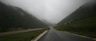
You will get to the desired resort city by highway or by train. Resorts of the North Caucasus always welcome guests. At any time of the year, here you can not only improve your body, but also remember what clean air and real relaxation are.
Territorial division
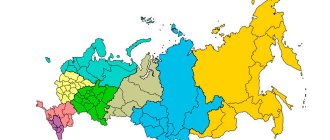
Currently, the Caucasus covers two autonomous regions of Russia: Stavropol and Krasnodar and seven republics. Many are now debating whether the Foothills are included in this region. Then this concept must include both the Rostov region and Kalmykia.
Republic
Now this region includes seven republics:
- Adyghe;
- Karachay-Cherkessia;
- Kabardino-Balkarian;
- North Ossetian;
- Ingush;
- Chechen;
- Dagestan.
Each of these republics is unique, beautiful in its own way, has its own ancient history and rich traditions, which have been strictly revered since ancient times to this day.
Adygea
The capital of this subject of the Russian Federation is the city of Maykop. The republic is part of the North Caucasus economic region. It is the only one of all the republics that is located on the territory of another region (Russia).
Adygea is located on the slopes of the North Caucasus and the plains of the Kuban. Its total area is 7800 square km. The climate of the republic is temperate continental, due to its close location to the Black Sea, and the mountains contribute to increased humidity levels in this region.
Karachay-Cherkessia
This republic has been part of Russia since 1957, its capital is the city of Cherkessk. It is located in the foothills of the Caucasus, but most of it is located in mountainous areas. On the border of the republic with Kabardino-Balkaria there is the highest mountain in Europe - Elbrus.
The population of this region speaks several languages:
- Russian;
- Nogai;
- Circassian;
- Karachay;
- Abaza
Russian is considered to be the official language here. The area of the republic is 14 thousand square meters. km.
There are many mineral deposits located on the territory of Karachay-Cherkessia:
- coal;
- granite;
- marble;
- ores;
- clay.
The republic is also famous for its healing mineral waters, which attract many visitors.
Kabardino-Balkaria
The capital of this subject of the Russian Federation is Nalchik. Its total area is 12,400 square meters. km.
The population speaks the following languages:
- Kabardian;
- Balkar;
- Russian;
- Ossetian;
- Turkish
The republic is located in the central part of the North Caucasus slope. The highest point of Elbrus is located on its territory. There are also five main ridges on it.
Kabardino-Balkaria is famous for its attractions:
- waterfalls (Gedmishkh, Sultan, Abai-Su);
- lakes (Tambukan, Shadhurey, etc.);
- rivers (Terek, Baksan, Malka).
Previously, there were two regions on the territory of this republic - Balkaria and Kabarda. They united in 1922.
North Ossetia
It has a different name - Alania, the capital of the republic is Vladikavkaz. It was founded in 1924. The population speaks Russian and Ossetian languages. The total area is 8 thousand square meters. km. It is located on the plains, and Kazbek peak is also located on its territory.
The republic has rich mineral deposits:
- lead;
- copper;
- oil;
- silver
There are also sources of medicinal mineral waters here.
Ingushetia
The capital of the Ingush Republic is the city of Magas. It has an area of 3.6 thousand square meters. km. It is the smallest region of the country. The north of Ingushetia is located in the steppes, the southern part is in the mountains. The largest peak is Mount Shan.
The climate here is temperate continental. Time zone: Moscow.
The republic is famous for its attractions:
- Furtoug Falls;
- Nazranka River;
- Sunzha River;
- Assa River.
This is not the entire list of rivers; their total basin is 3 thousand square meters. kilometers.
Ingushetia has rich mineral deposits:
- oil;
- marble;
- natural gas.
Also in the republic there is a source of Borjomi mineral water.
Chechnya
In Soviet times, Ingushetia and Chechnya were united into one republic - the Chechen-Ingush Autonomous Soviet Socialist Republic. Their division into separate republics occurred in 1993.
The capital of Chechnya is the city of Grozny. The total area of the republic is 15 thousand square meters. km.
Its relief is divided into four parts:
- Terek-Sunzha Upland;
- Terek-Kuma lowland;
- mountainous part;
- plain.
The mighty Terek River flows through the middle of the republic, sung by many poets. From north to south, the plain gradually gives way to mountains. Chechnya is famous for its beauty: deep lakes, waterfalls, turbulent mountain rivers. Lake Kezenoyam is especially famous. It is located high in the mountains, has the greatest depth and the purest water. It is home to trout. The beauty of this land is truly perfect.
The population speaks Russian and Chechen. The republic is known for its war with Russia in the 90s of the last century. Then it caused enormous damage to buildings and agriculture. Work is currently underway to restore civilian facilities.
Dagestan
The capital of Dagestan is the city of Makhachkala. The total area of the republic is 50 thousand square meters. km. Previously, this territory was the Caucasus province. In 1860, the Dagestan region was formed. In 1917 it was transformed into the Mountain Republic. Then it began to be called the North Caucasus Emirate. Since 1921 it has been the Dagestan Autonomous Soviet Socialist Republic.
The population of the republic is quite diverse, as is the religion of the peoples. Dagestan is famous for its ancient fortresses and temples. There is a nature reserve on the territory of the republic. Currently, mechanical engineering is developed.
The nature of Dagestan is beautiful - mountains, lakes, rivers. The climate is temperate continental, arid in places. Relief: mountains, foothills, plains.
This republic gave the world a famous poet - Rasul Gamzatov, who glorified the beauty of his native land and the generosity of the people in his works.
Seven republics of the North Caucasus
The ancient Greek geographer Strabo spoke in his works about the Scythians - tribes that lived in the Northern Black Sea region. This is one of the many peoples associated with the North Caucasus. Turbulent historical events forced people to move from the plains to the depths of the mountainous country, be it the indigenous inhabitants of the region or people from other places. As a result, a unique mosaic of nationalities and dialects has developed here.
The hospitality of the hosts is sometimes combined with customs and morals that are incomprehensible to Europeans, and adherence to traditions is combined with the desire to keep up with the times.
Agriculture, industrial production, mining and services for vacationers are the main areas of activity of the population of the North Caucasus. It is difficult to find a person in our country who has never vacationed in the Caucasus. The metals mined there are used in the production of many objects around us - this is the tungsten filament in a light bulb, and stainless steel utensils, and galvanized iron roofs, and much more. Jewelry and hard alloys, wool clothing and carpets made by residents of the North Caucasus can be found in all corners of Russia and beyond.
The population of the North Caucasus is more than 16 million people, or 11.3% of the population of all of Russia, while the area of the region is less than 1% of the country's territory. According to demographers, this is the only region in Russia today where the population is increasing. There are about a hundred nationalities and nationalities in Russia, and more than half of them are in the densely populated North Caucasus! Residents of one valley, and sometimes even one aul (mountain village), often do not understand the language of their neighbors from nearby villages.
Some Caucasian peoples number only a few hundred people, some hundreds of thousands.
The borders of the North Caucasus region were formed at the end of the 19th century, when the region was also called the Cis-Caucasian belt. Nowadays there are seven national republics on this territory: Adygea, Karachay-Cherkessia, Kabardino-Balkaria, North Ossetia-Alania, Ingushetia, the Chechen Republic, Dagestan.
ADYGEA
The Adygea Autonomous Region (area - 7.6 thousand km2) was formed in 1922 and was part of the Krasnodar Territory. Since 1992, Adygea has become an independent subject of the Russian Federation. Over 450 thousand people live in the republic. Approximately half of the territory of Adygea is on the plain, and half is on the mountains in the basins of the Belaya and Fars rivers.
The climate of the plain is mild and, in combination with black soil, allows for rich harvests of many agricultural crops - from wheat and rice to sugar beets and grapes. Mountains reaching 2 thousand meters are covered with forests. At an altitude of up to 1.2 thousand m, broad-leaved trees predominate - beech, oak, hornbeam; above - Nordmann fir; then there is small forest of birch, rowan and maple. Closer to the top there are subalpine and alpine meadows. The fauna of mountain forests is very rich: they are inhabited by bison, roe deer, chamois, mountain goats, wild boars, wolves, lynxes, bears, and many birds.
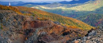
The Caucasian State Reserve is located in the high mountainous regions of the republic. Once upon a time, this was a place for royal hunting, as many names remind us of: the Panther and Solontsovy ridges, the Princely Bridge tract, the Bison Glade, the Kholodnaya, Grustnaya, and Turovaya rivers. In the reserve you can find fir trees that are more than 500 years old. They reach a height of 60 m with a trunk thickness of two to three girths. The combination of snow-white peaks, blue sky and huge green trees creates that unique landscape that attracts tourists here.
In the early 60s. XX century An attempt was made to build the Stavropol-Sochi highway through the central city of Adygea - Maykop. On this wide asphalt road there are still signs with the inscriptions: “To Sochi ... km.” But in Sochi you cannot drive along the highway: it reaches almost to the border of the reserve and suddenly ends. Common sense triumphed in time: a unique section of the territory was protected from a powerful flow of cars.
In addition to the beauty of nature, tourists are attracted to Adygea by ancient historical monuments - dolmens and burial mounds. An obelisk was erected in memory of the excavations of mounds in Maykop. Many works of art found by archaeologists are exhibited in the Hermitage.
Adygeis are one of the peoples united by a common name - Ady-gi. These also include Circassians and Kabardians. The ancestors of modern Adyghe people at different times bore the names Meots, Sinds, and Kerkets. Over the course of a long history, they mixed with the Sarmatians and Scythians, and were under the rule of Byzantium, the Golden Horde, Crimean Tatars, etc. In the 18th century. The Turks spread Islam in the North Caucasus, which is now practiced by the majority of Adyghe believers.
Adygea has a varied national composition, but the majority are Russians (67%) and Adygeis (22%). The influence of Russian and European culture in general on the Circassians is great: almost everyone knows Russian. At the same time, the Circassians preserved the language of their ancestors, religion, the nature of relationships within the family and community, and national crafts, including jewelry. They observe rituals associated with birth, death, coming of age, and weddings; They reverence natural and historical monuments, be it ancient dolmens or Christian churches and chapels. The settlements of the Adyghe people, both in the mountains and on the plain - surrounded by gardens, picturesque and neat - are usually large in size. Residents of Adygea are not only excellent farmers and shepherds, but also tourism and mountaineering instructors, scientists, and engineers.
KARACHAY-CHERKESSIA
Karachay-Cherkessia received the status of a republic within Russia in 1991. Its area is almost twice that of Adygea (14.1 thousand km2), but it is inferior in population (434 thousand people). Mainly Russians (42.4%), Karachais (31.2%) and Circassians (9.7%) live here. The Karachais settled in the high mountain areas, where they have long been engaged in cattle breeding. These people speak the Karachay language, which is related to the languages of the Turkic group. Some researchers consider the Karachais to be descendants of the Cumans, who once roamed the southern steppes and mixed with the indigenous Caucasian population. Modern Karachais prefer to live in the mountains, and high-mountain meadows serve them as pastures. Circassians are mainly engaged in agriculture and settle in the valleys.
The republic's subsoil is rich in minerals. The Urup deposit of copper pyrite has long been known. Since pre-revolutionary times, lead-zinc ore has been mined in the upper reaches of the Kuban at the Elbrus mine. But the mining industry is not the basis of the economy for Karach-evo-Cherkessia.
The multinational composition of the population is manifested in the diversified development of the republic's economy. If the Circassians are skilled gardeners and farmers, then the Karachais are famous as excellent livestock breeders. The Karachay sheep breed with its remarkable black fleece is well known. The Karachay horse breed is valued far beyond the Caucasus. Kefir, ayran - a drink made from sour milk, cheese and other dairy products are of high quality. Wherever tourists visit, there is a trade in handmade woolen products.
Although the area of arable land in the republic is small, a lot of potatoes, sugar beets and corn are grown here. In the north of Karacha-evo-Cherkessia, in Erken-Shahar, in the 60s. XX century The largest sugar factory in Russia was built. The republic's economy is focused on agriculture: its main sectors include livestock breeding and agriculture, production and repair of agricultural machinery, and food storage equipment. This direction of the economy is very favorable for the development of tourism and resort services.
Mountain lakes and waterfalls of Karachay-Cherkessia are accessible to the average pedestrian, glaciers and difficult routes are intended for climbers. There are many sources of mineral water on the territory of the republic. The mild, healing climate of mountain resorts also attracts people. Teberda, located at an altitude of 1.3 thousand m, is not much inferior to Kislovodsk, famous for its springs and air. In the upper reaches of the Teberda River, in a mountain basin, lies the world famous Dombay Glade - a favorite place for climbers, tourists and skiers. From here, even not very experienced tourists can easily climb to the Alibek glacier, follow the route to the Klukhorsky pass (2782 m) and to the blue Klukhorsky lake - small but deep, with floating ice floes in the hottest time of summer. At the pass during the Great Patriotic War there were stubborn battles with German troops.
KABARDINO-BALKARIA
The northern slope of the Greater Caucasus and part of the foothill plain are occupied by Kabardino-Balkaria. In area (12.5 thousand km2) it is slightly inferior to its western neighbor - Karachay-in-Cherkessia, and in population it is almost twice as large (790 thousand people). About half of the residents are Kabardians, about a third are Russians, and a tenth are Balkars. Kabardians belong to the group of Circassians. At certain periods of history they were very numerous and influential and even subjugated other peoples of the Caucasus. The Balkars are a Turkic-speaking people related to the Karachais; Previously they were called Mountain Tatars. Relations between Kabardians and Balkars with Russia have deep historical roots. In 1561, Ivan the Terrible married the daughter of the Kabardian prince Temryuk Aidarovich, who counted on Moscow’s support in defense against Crimea and Turkey. Then, during the period of weakening of Russia, Kabarda fell under Turkish rule. In the 19th century Kabardians and Balkars resisted the Russian Empire, but the bloodshed soon ended, giving way to alliance. The religious ideas of the Kabardians also changed repeatedly over the centuries. From ancient beliefs, the population first switched to Christianity under the influence of Byzantium and Georgia, but starting from the 15th century. Islam spread here. Some Kabardians (Mozdok) later converted to Orthodoxy again.
It is in Kabardino-Balkaria that the Greater Caucasus reaches its maximum height and is called Central here. In the Main and Side ranges, the peaks rise to more than 5 thousand m; there are many glaciers, including those more than 12 km long. All major valleys have roads that sometimes lead directly to the glaciers. However, none of them rises to the Main Ridge, all of the passes through which are very difficult to access. To the north of the Main Range there are the Rocky Range (3646 m - Mount Karakaya), the Pasture Range and the Black Mountains, behind which the Kabardian Plain begins with heights of about 150 m.
In the upper reaches of the Baksan River, from the Azau clearing at an altitude of 2.8 thousand m, you can take a cable car (cable car) up to a height of 3.5 thousand m to the slopes of the Elbrus volcanic cone, from where a magnificent panorama opens up - peaks covered with snow and glaciers, green valleys. From here the ascent to the top of the highest mountain in Russia (5642 m) begins.
The subsoil of Kabardino-Balkaria contains a variety of minerals. They have long been mined by local residents, using them to make household items, jewelry and weapons. Modern industry is also based on underground wealth. The most famous is the Tyrnyauz deposit of tungsten-ram-molybdenum ores; There are significant reserves of lead-zinc, lead-antimony ores, and iron. Coal mining is underway. Mineral springs, of which there are many in the republic, also serve various economic purposes, and hot mineral waters are used to heat greenhouses.
Forests occupy more than 15% of the republic's area, mainly in mountainous areas. The foothill plain within Kabardino-Balkaria is almost completely plowed. An irrigation system has been created here for centuries.
There are many interesting sites in the republic, and tourists willingly visit it all year round. In the mountains there are preserved ruins of ancient villages, cascading up the steep slopes. Defensive towers rise above them. Kabardino-Balkaria is home to one of the deepest lakes in Russia - Blue Lake (Tserikel). Its depth is 268 m, and this is despite its small size (width about 200 m).
The Narzan Valley is the traditional name of the section of the Khasaut River valley, where there are more than 20 large and many small springs along one kilometer of the path. On the Maly Larkhan River you can admire a 20-meter waterfall. The resort conditions of the Narzanov Valley are not inferior to the famous Kislovodsk. This mineral water is probably the most popular in the European part of Russia.
NORTH OSSETIA ALANIA
The Republic of North Ossetia-Alania covers an area of 8 thousand km2. Its population is about 650 thousand people, of which 53% are Ossetians, 30% are Russians. In terms of population density (more than 80 people per 1 km2) and degree of urbanization (70% live in cities), North Ossetia ranks first in the North Caucasus.
Ossetians are an ancient people. Among their ancestors there are indigenous Caucasians and representatives of Iranian-speaking tribes - the Scythians and Sarmatians (Alans). Ossetians once occupied vast spaces in the region. Tatar invasion of the 13th century. pushed them deep into the mountains behind the Main Range, to the southern slope of the Greater Caucasus. Most Ossetians profess Orthodoxy, which they accepted back in the 6th-7th centuries. under the influence of Byzantium and Georgia. There are also Muslims among the population; penetration of Islam in the 17th-18th centuries. Kabardians contributed. In 1774, Ossetia became part of Russia, after which its inhabitants began to move to the foothill plain.
The North Ossetian Autonomous Region was formed as part of the RSFSR in 1924; since 1936 it became an autonomous republic.
North Ossetia is located on the Ossetian Plain and occupies part of the northern slope of the Greater Caucasus. The mountainous territory of the republic includes the Side and Main ridges, and in the north the low (926 m) Sun-Zhensky ridge. The highest mountain - Kazbek (on the border with Georgia) - reaches a height of 5033 m. Other peaks are also high, from the slopes of which many glaciers descend, including the longest in the North Caucasus - Karaug: its length reaches 14 km.
The climate of the Ossetian Plain is favorable for growing corn, wheat, and sunflowers; Sugar beets also grow here, but they require additional watering. The average monthly temperature in January is -4°C, and in July +20-22°C; Precipitation per year is 500-800 mm. As you ascend into the mountains, it becomes cooler and the humidity increases. The mountain slopes up to a height of 2 thousand m are covered with forests, occupying a quarter of the republic’s area. Bear, lynx, marten, and fox can be found in these thickets. Above the forests is a belt of tall-grass subalpine meadows. At an altitude of more than 4 thousand m, the temperature does not rise above zero all year round. In winter, snow with a layer of 50-75 cm covers all mountain slopes, except for rocky cliffs.
North Ossetia is the only republic in the North Caucasus through which highways to Transcaucasia pass. One of them - the Military Ossetian - rises along the Ardon River valley to the Mamison Pass (2819 m), the other - the Military Georgian - passes through the Cross Pass (2379 m).
North Ossetia is famous for its fertile arable lands, lush gardens, high mountain pastures, virgin forests, mineral waters, and minerals. Already at the beginning of the 20th century. Several dozen deposits of copper, silver-zinc and iron ores were known. The land of North Ossetia is also rich in manganese, molybdenum, arsenic, sulfur pyrites, and jet (a valuable black ornamental stone that is used for jewelry). In the vicinity of Vladikavkaz, layers of sand saturated with oil were found.
In the largest Sadonsky silver-lead-zinc deposit, located 60 km west of Vladikavkaz, ore has been mined since ancient times. In the 19th century The Russian military department attracted Ural peasants to develop it. In 1896, the deposit was bought by the Belgians, who organized the Alagir joint-stock company, which equipped the mines, built a processing plant next to them, a small hydroelectric power station on the Sadon River, and an ore smelter in Vladikavkaz. Before the First World War, thousands of tons of zinc and lead and hundreds of kilograms of silver were smelted here every year.
In the modern economy of North Ossetia, non-ferrous metallurgy is the leading industry. The richest deposits (Sadonskoye, Fiagdonskoye, Zgidskoye, etc.) supply ore to processing plants located nearby. Concentrates are processed in Vladikavkaz.
In agriculture, grain production and horticulture are developed; small areas are occupied by vineyards. About half of the farmland is devoted to corn, a traditional crop in Ossetia. The republic has a large number of cattle and developed pig farming.
Industry and agriculture in North Ossetia are so developed that tourism is less important here than in other republics of the North Caucasus. Sightseers visit the Tseysky glacier, not far from which there is the ancient Ossetian sanctuary of Rekom.
Near the village of Darvas, several dozen burial grounds (family crypts) with burials of the 14th-19th centuries, known under the general name “City of the Dead,” have been preserved. In the mountainous regions of Ossetia there are ancient houses and tower-fortresses - witnesses of ancient customs and events.
INGUSHETIA
In 1924, the Ingush Autonomous Region was formed. In 1934, it merged with the Chechen Autonomous Region into the Chechen-Ingush Autonomous Region, which in 1936 was transformed into the Chechen-Ingush Autonomous Soviet Socialist Republic within the RSFSR. In 1992, after the separation of Chechnya, the Ingush Republic was proclaimed as part of the Russian Federation. This is the smallest Russian republic in terms of area (19.3 thousand km2) and population (about 300 thousand people). Its people are one of the most ancient in the North Caucasus.
Ingushetia is located east of Ossetia and occupies mainly the basin of the Assa River, a tributary of the Terek. The natural conditions in the republic are the same as in Ossetia. To the east of Vladikavkaz, the dry heat of the deserts is already slightly felt. The forests here slightly change their shade (hornbeam and oak predominate in the foothills and basins) and retreat slightly into the mountains.
The capital of Ingushetia, Nazran, with a population of 23 thousand people (1994), became a city in 1967. It is located on the Rostov-on-Don - Baku railway line. There are few industrial enterprises in Nazran: a power tools plant, a knitting factory, a flour mill.
The landmark of Ingushetia is its old architectural ensembles. First of all, these are the ruins of villages with battle towers from the 14th to 18th centuries. made of gray untreated stone. Some of them can be approached from the Georgian Military Road. On the southern slope of the Rocky Ridge, above the buildings destroyed by time, the slender silhouettes of surviving towers of five to six floors, with narrow loopholes, rise. Each tower gradually tapers and ends with a pyramid-shaped stone roof. At the second floor level there is a door from which a staircase was once lowered. Near the village of Khairakh in the valley of the Assa River, the Thiba Erdy temple of the 11th-13th centuries has been preserved. - evidence of the spread of Christian teaching among the Ingush.
CHECHEN REPUBLIC
In recent years, the Chechen Republic has become known throughout the world. The fighting on its territory, including in the capital Grozny, the bombing of this largest and richest city in the North Caucasus and its significant destruction, the death of thousands of people, refugees, hostages, kidnappings of residents - all these phenomena, wild even for the Middle Ages, attracted everyone's attention (see . article “War in Chechnya” in the volume “History of Russia”, part three, “Encyclopedia for Children”).
The Chechen Autonomous Region was formed in 1922 and then merged with the Ingush Autonomous Region into the Chechen-Ingush Autonomous Soviet Socialist Republic. In 1991, Chechen leaders announced the creation of a sovereign and independent Chechen Republic - Ichkeria, separated from Ingushetia and generally from Russia.
However, according to the current Russian Constitution, Chechnya is a subject of the Russian Federation. By agreement of the parties, the final decision on the status of the republic was postponed until the beginning of the 21st century.
In terms of population and area, the Chechen Republic is approximately 2.5-3 times smaller than Dagestan, located to the east, and significantly larger than Ingushetia. The total number of Chechens within Russia is almost 900 thousand people (according to 1989 data); Of these, approximately 400 thousand live in Chechnya itself.
Chechens and Ingush are close in language, origin, customs and way of life. The Chechens adopted Islam quite late (although much earlier than the Ingush): in the 18th-19th centuries. The nature of the two republics is very similar. However, only in the depths of Chechnya there are oil reserves, which largely determined its development in the 20th century.
The Chechen Republic is located on the northern slope of the Greater Caucasus and on the adjacent Terek-Sunzha Plain. The highest point on the territory of Chechnya is Mount Tebulosmta (4493 m). The plain is covered with fertile black soils; the mountains are covered with forests, 80% of which are tall beech trees. In the southern part of Chechnya, mineral deposits have been discovered: copper ores near the village of Evdokimova, silver-lead ores near the village of Kei, and sulfur near the village of Shatoy. There are also antimony, gypsum and other minerals. At the beginning of the 20th century. the population was mainly engaged in agriculture. Wheat, corn, and millet were sown on the plains; sheep and racing horses were bred in the mountains. Beekeeping was quite widespread. In the northern regions they made cloth, and in the southern regions - burkas. Blacksmithing and jewelry making were developed.
The modern economy includes traditional occupations, to which were added irrigated agriculture on the plain and a powerful industry associated with the exploration, production and refining of oil. In the landscape of Chechnya, interweaving pipes, oil rigs and tanks occupy a prominent place. The republic's oil fields are not gigantic, like those in Siberia or the Middle East, but they are convenient for development.
On the southern slope of the Sunzhensky ridge, 40 kilometers west of Grozny, there is a large resort of Sernovodsk with healing mineral springs. In general, in terms of the wealth and diversity of natural resources, Chechnya is not much inferior to the other North Caucasian republics, and in terms of oil reserves it surpasses them all.
DAGESTAN
The largest of the North Caucasian republics both in area (50.3 thousand km2) and in population (almost 2 million people) is Dagestan. In addition, it is the most energy-rich, driest, warmest and most treeless republic in the region. Dagestan has also set several all-Russian records. Here the population continues to grow the fastest (against the background of its decline in the country as a whole). More than 30 nationalities inhabiting Dagestan speak 29 languages and 70 dialects; According to these indicators, the republic can even lay claim to the world championship.
Islam penetrated into Dagestan earlier than into other North Caucasian republics; Perhaps for this reason, the inhabitants of the republic are most committed to Islam. 57% of the population of Dagestan lives in villages; At the same time, nowhere in the North Caucasus are there cities as ancient as in Dagestan: Derbent, for example, is more than 5 thousand years old - it is the oldest city in Russia. Even the nature of the republic is unique: here is the lowest point in Russia and Europe - 26 m below sea level.
Dagestan is located at the Caspian Gate - where the path from Transcaucasia to the northern plains begins. The peoples of the republic often suffered from the raids of conquerors. Residents took refuge in the mountains, behind narrow gorges, on inaccessible plateaus. Plains from the 8th to the end of the 10th century. occupied by the Khazar Khaganate, the Caspian Sea in those days was called the Khazar Sea. The capital of the Kaganate was then located on the site of the modern village of Tarki not far from Makhachkala.
The largest indigenous peoples of Dagestan are Avars (27%), Dargins (15%), Kumyks (13%), Lezgins (11%), Laks, as well as Tabasarans, Nogais, Tats, Aguls, Rutuls, Tsakhurs. There are nationalities that are very small in number. Thus, the village of Ginukh, with several dozen houses, has its own language and customs.
The diversity of natural conditions and the richness of national traditions determined the characteristics of numerous folk crafts. Almost everywhere there are masters. Goldsmiths and jewelers work in the famous village of Kubachi, ceramics are produced in Gotsatl, carpets are produced in Untsukul, etc.
Despite the mixture of peoples and languages, Dagestan has been perceived as an integral country for hundreds of years. In 1921, the Dagestan Autonomous Soviet Socialist Republic was created, and in 1991, the Republic of Dagestan was proclaimed as part of Russia.
Translated from Turkic, Dagestan means “country of mountains.” However, it occupies not only the mountains of the eastern part of the North Caucasus, but also the adjacent Caspian plains. Steppe and semi-desert lowlands extend to the north of the ridges for almost 200 km, and mountains continue to the south, also for almost 200 km. The Caspian coast is the warmest corner of the North Caucasus. The average monthly temperature in January here is above zero, as on the Black Sea coast, and in July it is even hotter - up to +24 °C. However, in these places the mountains no longer protect from northern winds, so in winter there are severe frosts - in the north of the republic down to -40 ° C.
The mountains of Dagestan are high, with steep slopes. The height of the Bazar-Dyuzu peak on the border with Azerbaijan is 4466 m. The climate in the mountains is quite dry, so there are few glaciers. Vast spaces are occupied by high (2.3-2.7 thousand m) plateaus, the most famous of which are Khunzakh and Gunib.
The mountains of Dagestan are cut by the deepest canyons of rivers (Sulak, Sa-mur) and their tributaries. The Sulak gorge between the Gimrinsky ridge and Sulak-tau was once the site of fierce battles between Shamil’s rebels and the troops of the Russian Tsar (1832).
Now the highest (231 m) mud dam has been built here on other rivers of Dagestan. They not only provide the republic with electricity, but also irrigate the lands in the mountains and plains. Valuable fish are found at the river mouths, including sturgeon, beluga, stellate sturgeon, Caspian salmon, and whitefish. Red deer, wild boar, and many birds live in the reed thickets covering the coastal floodplains (the banks flooded in the spring).
In the forests - they occupy only 7% of the mountain area - there are wolves, bears and lynxes. In the foothills you can see a large (25-30 cm) turtle, snakes - a huge brown viper sleeping on the stones, a bright green snake. On the plains, in the steppes and semi-deserts, the fauna is different in nature: birds, various rodents, in the very north - saigas, the steppe fox - corsac fox.
The mountains of Dagestan are a kind of fortress protecting the population of the interior regions. You can get here from the plains, usually by passing through narrow, insurmountable gorges. At the same time, in the mountains themselves there are many wide, convenient valleys where you can engage in agriculture and build housing. The sun-scorched mountain slopes are densely populated: tens of thousands of people live in some villages.
Mountain villages are connected by highways that wind through serpentines. The gray cubes of houses are molded one to the other and on top of each other, hanging over the slopes of the mountains like swallows' nests. There is neither a green lawn nor a tree here. In the mountains, houses are not built on land suitable for cultivation, saving it for arable land. To expand the fields, artificial terraces were created on steep slopes and soil was brought here. Now these plots are amazingly well-groomed. However, with the advent of cheaper grain produced on the plains, the terraces began to be used mainly as meadows. Sheep and horse breeding is an important sector of the Dagestan economy. In summer, animals are grazed in alpine meadows, and in winter - in the steppe, on the plain. Sheep are sometimes transported by car, reducing losses from long hauls. There are many gardens and vineyards in the mountain valleys and foothills, the fruits of which are used in large quantities for the production of canned food and wine.
The flat part of Dagestan is located on the territory of the Caspian lowland. Within the republic it is called Tersko-Kumskaya (north of the Terek) and Tersko-Sulak or Kumykskaya (to the south). Flat near the coast, the Terek-Kuma Lowland gradually rises as it moves away from the Caspian Sea, and irregularities appear on it - sand dunes and ridges fixed by vegetation. This part is called the Nogai steppe. The landscapes here are mostly steppe and semi-desert, with some salt marshes. Wormwood, solyanka, cereals and herbs grow in sparse bushes. The main wealth of the Nogai steppe is pastures where fine-wool and coarse-wool sheep are bred. Farming is of an auxiliary nature. Most of the indigenous population are Nogais, descendants of a once numerous and formidable horde that roamed the plains of the North Caucasus. They are a Turkic-speaking people with a centuries-old history. The traditional occupation of the Nogais is cattle breeding, but among them, like hundreds of years ago, today there are representatives of a variety of professions. Modern Nogais lead a mostly sedentary lifestyle. Their settlements are located near irrigation canals and with many windmills (wind power installations) resemble Dutch villages. However, if in Holland they drain land with the help of windmills, then in Dagestan they are used to water gardens and vegetable gardens.
The Kumyk Plain, like the Nogai steppe, was named after the people inhabiting it - the Kumyks. The lands located between the foot of the mountains and the Terek are convenient for cultivation: there are many vineyards and gardens, especially near Makhachkala. Kumyk settlements usually look like a large garden with whitewashed houses.
No large deposits of mineral raw materials have yet been discovered in the depths of Dagestan, but there are many small ones. Literally “from near Makhachkala”, oil was extracted for two decades, starting in 1942. In 1972, the development of the Shamkhal-Bulak gas field began, from which gas pipelines stretched to all ends of the republic. Deposits of iron ore, gypsum, alabaster, building stone, glass sand, mineral and thermal (warm) waters provide a variety of needs for the modern economy of Dagestan.
The Caspian Sea is rich in a variety of fish. The most valuable are sturgeon, the caviar of which is worth almost its weight in gold. The beaches of Dagestan are wonderful, vast and sandy, with sloping shores. This is an ideal place for a children's holiday. However, there are still no traditions of tourist services here and resort resources are very poorly developed.
The nature of Dagestan is not only generous, but also harsh in the manifestation of its elements. In 1970, the strongest earthquake in the North Caucasus occurred here, from which several cities and villages suffered. At this time, large landslides and landslides occurred in the mountains. The storms of the Caspian Sea are also very severe. Fishermen used to say: “Whoever has never been to the sea has never seen grief.” Since 1978, the level of the Caspian Sea began to rise rapidly. Farmland is flooded, homes and roads are destroyed, so dams have to be built or buildings have to be moved further from the sea.
The capital of Dagestan, Makhachkala, is located on the shores of the Caspian Sea, at the foot of Mount Tarkitau. It was founded as a military fortification in 1844 near the place where Peter I had his camp in 1722. The mountaineers called the fortification Angi-Kala - Flour Fortress. In 1857, the fortress received the status of a city and the name Petrovsk-Port. Soon the port itself was built, and in 1896 a railway was brought to it. The city was renamed Makhachkala - in honor of an active participant in the civil war, Makhach Dakhadayev. The population of the city is 395 thousand people. A beautiful center built at the end of the 19th - beginning of the 20th century. surrounded by modern neighborhoods and factories. The city is home to the Dagestan Scientific Center of the Russian Academy of Sciences, theaters and museums.
Machines, instruments, building materials are produced in Makhachkala, and the food industry is developed. The city itself is a balneological and seaside climatic resort: its mineral waters, therapeutic muds, extensive sandy beaches and warm sea are widely used.
The small (44 thousand people) city of Kizlyar is located on a plain in the Terek delta. It was first mentioned in 1652. In 1735, the first Russian fortress in the Caucasus was founded in this place. In the second half of the 18th century. Kizlyar was the administrative and commercial center of the North Caucasus; not only Persian but also Indian merchants traded in its bazaars. The city has traditionally been famous for its vineyards and winemaking. This is due to the fact that at the beginning of the 18th century. Many Armenians and Georgians moved here. Despite its small size, Kizlyar is the cultural center of Dagestan. The city has several museums and many historical monuments.
History of formation
According to ancient written evidence, the first inhabitants of these places were the Cimmerians. They were engaged in cattle breeding and fought with the Scythians who entered their land. In the fourth century AD, the Huns began to invade these places. In the 7th century, Turkic-speaking Bulgars moved here. In the 8th century, the Caucasus belonged to Khazaria.
In the first millennium, four regions were formed in the Caucasus:
- Pre-Caucasian;
- Dagestan;
- Zakubansky;
- Central Caucasian.
The ancestors of the Circassians were located on the left bank of the Kuban. In the eastern part of the Kuban region there was the ancient country of Alania (the ancestor of modern North Ossetia).
From the 7th to the 10th centuries, the Arab conquests of the Caucasus took place. They spread Islam among the local population. In the 13th century, the Mongol campaigns began in the Caucasus. They completely destroyed the population of Alanya. In the 16th century, the struggle for the Caucasus began between Iran and the Ottoman Empire.
At the same time, the Russian state occupied the lands of the Caucasus. The Russian border passed through this region in the 16th century. At this time, the Terki fortress was built at the confluence of the Terek and the Sunzha. Russian Cossacks settled there and began to be called “Terek”.
In the 18th century, Ossetians and Ingush joined Russia. At the same time, our state took away the right bank of the Kuban River from Turkey. Zaporozhye Cossacks began to move there. The city of Ekaterinodar (Krasnodar) was founded.
In the same century, the Caucasian province was founded. It included six districts, its center was Ekaterinodar. Then in the 19th century the city of Armavir was founded.
After the October Revolution, the province began to be called the Mountain Republic. Two years later it split into separate areas. They became part of the USSR as autonomous republics. After the collapse of the Soviet Union, they again became independent, but are part of Russia.
Policy
The Plenipotentiary Representative of the President of Russia in the North Caucasus is Alexander Anatolyevich Matovnikov. He was the commander of the Special Operations Forces of the GRU of the General Staff of the Russian Armed Forces. He holds the rank of lieutenant general.
The foreign and domestic policy of the Caucasus remains the country's most pressing problem due to armed conflicts. For two decades now, the situation in this region has remained turbulent. Great efforts and attention are needed to resolve these issues.
The first Chechen conflict was from 1994 to 1996. After the declaration of war on Russia, Russian troops were sent into Chechnya. Contrary to expectations, it was not possible to quickly resolve the situation. The conflict dragged on for two years. Many Russian guys died. The Chechens turned into terrorists and took hostages—civilian village residents. In 1996, a truce was achieved.
But three years later, the Chechen conflict flared up with renewed vigor. The militants again began terrorist activities, and Russian troops had to be sent into Chechnya again. The bandits were driven into the mountains. The fighting ended by 2002. The following year, the Chechen Republic was formed, President Kadyrov was elected, and a constitution was adopted.
The Russian government suffered great losses, both material and moral. More than 25 thousand Russian people were killed in this war. This number exceeds losses during the Afghan war.
Until now, there are complex relations between the peoples of the Caucasus. Therefore, our government tirelessly protects state security.
The situation in the region is especially dangerous due to aggressive actions by Islamists.
Resort town of Essentuki
Here diseases of the liver and stomach are effectively treated, and the body’s metabolic processes are restored. Twenty-nine medical institutions accept holidaymakers and patients all year round.
The city's attractions include the musical fountain, which is located on Theater Square. This is the largest fountain in the Caucasus. Its area is 400 sq. m. Every minute it throws out 10 tons of water. In the evenings, the lights come on and music plays. The fountain turns into a bright water show.
All the city's attractions are concentrated in the city park. The park was founded by order of Count Vorontsov. In the middle of the 19th century, sixty hectares of marshy land were drained and planted with trees, a gallery of spring No. 17 was built, and recreation areas were organized.
At the beginning of the park stands the Theater Park building, a beautiful structure with arched windows. Sobinov and Chaliapin performed here at one time. Now it is a platform where various events are held.
Source Gallery No. 17 is the oldest building in Essentuki, dating back to 1858. The Moorish style and the Gothic English style give the building a solemn and unique appearance. Now narzan is served at different temperatures, you can drink as much as you want, and it’s free.
The Tsander Mechanotherapeutic Institute will surprise you with its appearance.
You will see a modern building with turrets, arches and spiers. The building contained extraordinary devices, prototypes of simulators, with the help of which people were treated with movement. All devices are still functioning and can be used.
And the modest-looking building of modern construction turns out to be pavilion No. 4. It is served with the famous Essentuki-4, which is considered the most delicious mineral water.
In Essentuki you can observe with your own eyes the process of the birth of underground springs. In the Weeping Grotto this secret of nature will be revealed. The ceiling of the cave is covered with stalactites, from which the purest drops of mineral water fall into a small reservoir, the water from which slowly seeps through the ground, forming a small mineral spring.
The most striking attraction of the city is the mud bath named after Semashko. The building looks like an ancient temple, and not a medical institution. It is decorated with statues of lions, statues of Greek gods, numerous bas-reliefs and columns. The mud bath is recognized as the most beautiful mud bath in Europe.
At any time, from the moment of its creation to the present day, the mud baths are equipped with the latest science. Just like 100 years ago, today patients receive numerous medical procedures here.
National composition
People of different nationalities live in this region. These are representatives of different anthropological types of Caucasian races.
Representatives of the Caucasian type:
- Aguls;
- Balkars;
- Dargins;
- Ingush;
- Karachais;
- Lezgins;
- Ossetians;
- Chechens;
- Georgians;
- Kakhetians, etc.
The Pontic type includes:
- Abkhazians;
- Adyghe people;
- Kabardians;
- Circassians;
- Pontic Greeks;
- southern Russians and Ukrainians.
Representatives of the Caspian subtype:
- Kumyks;
- Azerbaijanis;
- Tsakhur;
- tatas, etc.
The Armenoid type includes:
- Assyrians;
- Armenians;
- southeastern Georgians.
In terms of population in this region, the palm is held by the Chechens, Adygs, and Abkhazians. The natural increase in the birth rate here is quite high. And mortality is reduced compared to other zones due to favorable living conditions and morality (mountain peoples do not have abortions and raise their youth strictly).
Sochi is the most beautiful city in the Western Caucasus
This urban district, although it gained tourist popularity quite a long time ago, finally earned the above title thanks to the 2014 Winter Olympics. It was she who turned an average resort, not without infrastructural problems, into a “European” center of year-round entertainment. Many are amazed by its chic transport hub, which occupies part of the Adler microdistrict, as well as Olympic and Sochi Park, which occupy the entire Imereti Lowland. At the same time, at the height of summer, utility problems have not been resolved in most of the local residential sectors, and from the early evening the southern microdistricts of Greater Sochi are always stuck in traffic jams.
Relief and climate
The relief of this beautiful region is varied. Usually, judging by its name, it is associated with the Caucasus Mountains, but on the map not all of its territory is located in mountainous areas. For example, the north of the region lies on plains called the “foothills of the Caucasus.” Gradually, to the south there is an increase in the terrain, which turns into mountains called the Greater Caucasus.
The altitude also varies from one area to another. For example, the Stavropol Territory is located at an altitude of 2.3 km above sea level, and the northern foothills are at an altitude of 600 m.
The climate in this region also varies depending on location. Mainly temperate continental prevails, but arid tropical is also found.
Flora
The nature of this region is truly unique. It is unlikely that such beauty can be found anywhere else on the planet. High mountain peaks covered with snow, fast mountain rivers, clear lakes, magnificent waterfalls. All this is due to the features of the relief. The vegetation of this region deserves special attention. The strange flowers that grow at the foot of the mountains are bright, as if painted.
Since ancient times, these places have attracted creative people: artists and poets. Pushkin and Lermontov were inspired by the local nature. They loved to visit here often, because they were inspired by the beautiful landscapes.
The Caucasus is famous for its medicinal herbs. Many useful plants grow in this area that help with various ailments.
Among them:
- Horse chestnut (helps with varicose veins, blood clots, high cholesterol).
- Lungwort (useful for pancreatitis, cholecystitis, gout, diabetes, female bleeding).
- Chernogolovka (stops bleeding, has an antimicrobial and astringent effect).
- Adam's root (useful for impotence, rheumatism, gout, osteochondrosis).
Fauna
The fauna of the Caucasus is no less diverse and unique. Rare species of individuals are found here, many of them are listed in the Red Book. Nowadays, it is increasingly rare to see animals such as bison, black stork, and Hungarian goat. There are minks in the rivers, where they hunt fish. The mountains are inhabited by roe deer, mountain goats, wild boars, and wild bears.
Natural areas of the North Caucasus
The North Caucasus occupies a huge area, therefore there are several natural areas in it.
Steppe . The steppe zone is part of the territory in the north of the region, between the Terek and Kuban rivers. Steppes occupy a large area of the North Caucasus. The soils there are mostly black soil, so most of the steppes have been converted to agricultural land. They not only grow various crops, but also graze livestock.
Foothills . The foothill zone is located in the southern part of the region. Here the steppes give way to a strip of foothill forests. First there are broad-leaved forests, then coniferous ones. The foothill zone is small - it occupies about 10% of the entire territory of the region. Wood is mainly imported to the North Caucasus from other regions, since deforestation in the foothills is difficult due to the unevenness of the landscape.
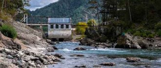
Mountains . The mountains are located on the isthmus between the Black and Caspian seas. The North Caucasus Mountains are considered quite young and continue to grow to this day. The peaks of the Caucasus Mountains are always snow-covered.
The region's two main rivers, the Terek and the Kuban, are fed by waters formed as a result of the melting of glaciers in the mountains. This area is dangerous due to avalanches, earthquakes and landslides.
Plants of the North Caucasus
It was already noted above that the flora in this region is very diverse. Here you will find plants that cannot be found anywhere else in Russia: Caucasian blueberry, Bortkevich snowdrop, Lesnek primrose, etc.
Forests in the North Caucasus are mainly coniferous, but you can also find trees such as sloe, medlar, cherry, apple, cherry plum and dogwood.
If you want to admire beautiful flowers, you should visit North Ossetia - it is famous for its meadows, which amaze with the flowering of forget-me-nots, anemones, gentians, etc. There are also plants listed in the Red Book.
There are several nature reserves in the North Caucasus where nature, including the flora, has been preserved in its original form.
Religion and culture
Religion
The religious denominations of the residents are different. Most of the population professes Islam.
Among them:
- Avars;
- Adyghe people;
- Balkars;
- Ingush;
- Kabardians;
- Karachais;
- Lezgins;
- Nogais;
- Chechens;
- Circassians;
- Azerbaijanis;
- tatas, etc.
There are Orthodox Christians among the population of the Caucasus.
These include:
- Ossetians;
- Abkhazians;
- Georgians;
- Russians;
- Ukrainians.
There are also Christians of other denominations:
- Armenians;
- Assyrians;
- undines.
Among the Jews are Mountain and Georgian Jews. In this area you can find Orthodox churches next to mosques. Muslims have a normal attitude towards the presence of other religions, not counting the militant ones, which have repeatedly caused armed conflicts based on religious affiliation between the peoples of the Caucasus.
Culture
For a long time, cultural traditions have been revered in these places. Unique melodies, fire dances, peculiarities of singing songs - all this is passed on from generation to generation. Folk singing is more widespread here than anywhere else, and many have an excellent ear for music. Songs accompany all rituals in this area, from the birth of a child to funerals.
Unique wedding and folk holiday chants vary depending on location. Among the Terek Cossacks you can hear something that is not at all similar to Ossetian.
Dances of mountain peoples are a separate topic. It’s rare to find such rhythmic, unique, fiery dances. Take at least Lezginka.
The costumes of the peoples of the Caucasus are also varied. Adygs, for example, can be easily distinguished from Chechens. But all the peoples of this region share common characteristics: reverence for elders, love of tradition, respect for women, courage and self-sacrifice.
Zheleznovodsk, the smallest resort in the North Caucasus
Small but very cozy Zheleznovodsk is located in a mountain valley and is surrounded by relict forests. Because of its special microclimate, it is called little Switzerland.
The air here is saturated not only with oxygen, but also with beneficial ions, which promotes a speedy recovery. There are twenty-three sources of healing waters in Zheleznovodsk, three of which have received international recognition. The main activity of city guests is to receive health treatments and stroll in the Healing Park.
The main attraction of the city is the palace of the Emir of Bukhara. The emir did not have good health, so he visited many resorts in Russia, but most often lived in Zheleznovodsk, which is why he built a palace here. Today the emir's palace is part of the Telman sanatorium.
In Zheleznovodsk there are good walks around the city. The Saltpetry Rocks are worth a visit. On their slopes there are streaks of natural saltpeter.
Here, in the 20th century, the dwelling of a primitive man with tools and arrows was discovered. A small cave was found with a leveled floor and walls; there was a crack in the ceiling through which smoke from the fireplace was escaping.
An interesting natural miracle can be seen at the foot of Mount Zheleznaya. It is called the permafrost grotto. This is a cave in which even in the summer heat the air temperature does not rise above zero. There is no other cave like this in any country in the world. When scientists began to study this feature, it turned out that the walls of the grotto were petrified magma, in which cracks and crevices had formed, through which somehow cold air was drawn in in winter, and in summer, when it was hot, on the contrary, icy air came out.
Economy
The economy of this region is directly related to exports, because this is where natural gas and oil are produced. Rare and non-ferrous metals (lead, zinc, molybdenum, tungsten, etc.) are mined in mountainous areas. The Rostov region is rich in coal. The foothills are a storehouse of metallurgical, chemical, and construction raw materials.
Mechanical engineering is also developed here. The large enterprise RosNefteGazInstrument is known. Oil and gas equipment for drilling wells is produced here.
The entire Caucasus is also called the “health resort of Russia.” People from all over the country come here to relax, recuperate and heal. Many sanatoriums are located in the mountains. Those suffering from diseases of the digestive and excretory system are treated with mineral waters. Pyatigorsk and Minvody are centers of healing springs.
The Baku-Novorossiysk oil pipeline and the Blue Stream gas pipeline connecting Turkey and Russia pass through this region. Large highways lead to Novorossiysk (M4 Don), and the M29 Caucasus highway leads to Mineralnye Vody.
This region is considered particularly fertile. The harvest is harvested several times a year due to the warm climate and favorable conditions.
Kislovodsk, the largest resort in the North Caucasus
Kislovodsk is the largest and most beautiful city of the KavMin group, the second in Russia among climatic resorts after Sochi.
A third of all sanatoriums of the KavMin group, or rather 43 sanatoriums, are located in Kislovodsk. It is surrounded by mountains, protecting it from winds and fogs. Kislovodsk has a special microclimate with a lot of sunny days.
During Tsarist Russia, the city was visited by nobility and famous people of that era to improve their health: Mikhail Lermontov and Leo Tolstoy, Alexander Pushkin and Anton Chekhov enjoyed their holidays in Kislovodsk. Healing Narzan is not only drunk. People also take narzan baths here.
In addition to health procedures, there is something to see and be surprised in Kislovodsk.
For example, Chaliapin's dacha. Now it is an art museum, it hosts festivals, meetings of writers and musicians, and exhibitions.
There is an unusually beautiful park in Kislovodsk. On a thousand hectares of land, not only local plants grow, but also their rare species. The infrastructure is well developed. Lots of cafes, restaurants, souvenir shops. There are photographer services, swimming pools, a spring, a cable car - in general, there is everything for visitors to enjoy. The park is officially recognized as the best park in Russia, and one of the most beautiful parks in Europe.
The Valley of Roses is located on the territory of the park. In summer, during the period of lush flowering of roses, shrubs and other plants, the valley is especially beautiful. It is filled with bright colors and aromas and is loved by locals and vacationers. There are always a lot of people here, and there is enough space for everyone.
The Mirror Pond is considered a man-made landmark of Kislovodsk. A romantic place filled with peace and quiet.
The Narzan Gallery of Kislovodsk is worthy of attention. It is located in the very center of the city, next to a park in a Gothic style building. You can drink several types of narzan as much as you want and absolutely free, you can take water with you.
The Church of the Exaltation of the Holy Cross is worth a visit. This is a unique, the only temple in Russia with this style of construction.
In addition, in Kislovodsk there is a museum of musical and theatrical culture, a philharmonic society, and Rebrov’s house.
Landmark of the city Mount Ring. An eight-meter arch was formed right in the rock under the influence of natural elements. Local residents believe that after passing through it and drinking Narzan from the spring, a person becomes stronger in body and stronger in spirit.
Not far from Kislovodsk there is Lermontov Rock. It was here that the duel between Pechorin and Grushnitsky took place, described by Lermontov in the story “Princess Mary”.
If you love legends, visit the rock Castle of Treachery and Love. This picturesque place is located four kilometers from the city. According to legend, the prince's daughter fell in love with a shepherd. The love was mutual, but the girl's father was going to give her to an old and rich man. The lovers decide to jump from the mountain, but only the shepherd jumped into the abyss.
Having married an old and rich man, the girl did not live long and soon the grief-stricken father, petrified, turned into a rock. Now a castle-style hotel has been built here, and the picturesque Alikonovskoe Gorge (the shepherd who jumped off in love was named Ali) adds to the charm of this place.
Honey waterfalls rage in the Alikonovsky Gorge. Falling streams of water have formed small lakes; tourists love to swim in them. There is such a variety of herbs and aromas around the waterfalls that people came up with another legend: once upon a time bees lived in this place, and they had so much honey that it poured into the streams of the waterfalls, making the water in them honey-like. A beautiful legend and an equally beautiful place.
Interesting Facts
In the Caucasus, the places of residence of the great Russian poets - Pushkin and Lermontov - are honored. Monuments to Pushkin stand in the places where he visited (in the city of Ordzhonikidze, Georgievsk, Pyatigorsk. It was here that he wrote his brilliant work “Prisoner of the Caucasus,” although it was originally intended to be created in Georgia. This poem was based on descriptions of the nature of the Caucasus.
Lermontov also often visited these places.
He lived :
- in Pyatigorsk;
- in Stavropol;
- in Zheleznovodsk;
- in Chechnya;
- in Dagestan;
- in Kislovodsk.
The poet loved the Caucasus very much; descriptions of the local nature can be found in many of his works (“Hero of Our Time”, “Demon”, “Mtsyri”, “Dream”, etc.) At first he was forced to visit these places for health reasons, but over time he loved the Caucasus so much that he could not live without it. how many oceans are there on earth, read our article.
Pyatigorsk
Pyatigorsk is the oldest mud clinic in Russia. A large number of sanatoriums, boarding houses, children's camps and tourist centers annually welcome thousands of Russian and foreign tourists. In Pyatigorsk you can not only improve your health, but also enjoy the sights of this resort.
One of these attractions is the Lermontov Museum-Reserve. In practice, this is a complex of four objects of historical significance: Lermontov’s house, the Alyabyev house museum, the literary department, and the Lermontov department in fine arts.
A monument erected on the site of the famous duel between Lermontov and Martynov, which took place on the slope of Mount Mashuk, has been declared a cultural heritage of the country.
You can also visit the Mikhailovskaya Gallery. Now it is an art gallery, but historically it is the first Narzan gallery in the Caucasus.
On Mount Mashuk, or rather on the Mikhailovsky spur, there is the “Eolian Harp”, a gazebo, the prototype of which was the London Temple of Aeolus. For about a hundred years, there stood an air harp, a musical instrument (aeolophone), the strings of which produce melodic sounds thanks to gusts of wind.
A cave was formed on Mount Mashuk, the depth of which is about 40 meters; the cave resembles a funnel, the bottom of which is filled with turquoise-colored water.
At the approach to Lake Proval there is a two-meter high monument to the great schemer Ostap Bender. Lake Proval itself is a unique natural attraction, the pearl of the resorts of the North Caucasus.