The harsh northern region is beautiful and distant. These definitions fully apply to the Yamalo-Nenets Autonomous Okrug. On this land, surrounded by pristine nature, indigenous peoples live according to the customs of their ancestors, and the rich mineral resources are developed using modern technologies. Yamal has always attracted travelers with its unique appearance. Here, the stinginess of the sun and the originality of nature, the severity of the climate and the hospitality of the local residents, the fantastic palette of autumn and the silent whiteness of winter are combined in the most amazing way. Scientists love Yamal for its cultural richness and unique nature. Therefore, be sure to come to the Yamalo-Nenets Autonomous Okrug (capital Salekhard) to enjoy the cleanest air and see more closely the beauty of remote corners of our big country.
Geography
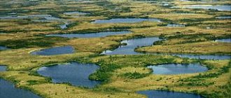
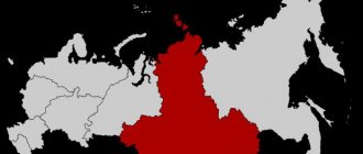
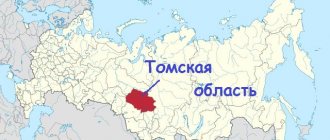
Russia is beautiful and rich: the Yamalo-Nenets Autonomous Okrug is the black pearl of the northern part of our country. And it occupies no less than 770 thousand square kilometers of the West Siberian Plain. The district includes: the Gydansky Peninsula, the Tazovsky Peninsula and, of course, the Yamal Peninsula. Most of the district is located beyond the Arctic Circle. From the north, the Yamal-Nenets Autonomous Okrug is washed by the Kara Sea, from the south it is adjacent to the Khanty-Mansi Autonomous Okrug, its eastern neighbors are the Taimyr and Evenki Autonomous Okrug, and from the west it borders on the Arkhangelsk Region and the Komi Republic. The relief of the Yamal-Nenets Autonomous Okrug can be divided into flat and mountainous. All three peninsulas are dotted with small rivers, hollows, ravines and swamps. The mountain range stretches for two hundred kilometers in a narrow strip along the Polar Urals. The climate of the Yamal-Nenets Autonomous Okrug is sharply continental, harsh, and is divided into three zones: the northern zone of the West Siberian Lowland, subarctic and arctic. The population is approximately 500 thousand people with a density of less than one person per square kilometer.
Brief recommendations for those traveling to Salekhard for the first time
Anyone going to Yamal for the first time may find some brief tips useful:
- Aerosols and other mosquito repellents and clothing that is as closed as possible are protection from rampant mosquitoes and annoying midges.
- Waterproof shoes are the best footwear for the swampy tundra.
- The Tundra hospitably opens its arms to everyone, and you need to treat it in such a way as not to hurt it with your presence. Since ancient times, traditional shoes of northern peoples have been made in such a way as not to damage the soil cover, not to harm the northern nature, which generously gifts everyone: deer with moss, people with mushrooms and berries, and sometimes takes centuries to restore strength and natural resources.
Salekhard, Russia, Arctic Circle - a world where nature is strict and majestic, and people are open and hospitable.
Flora
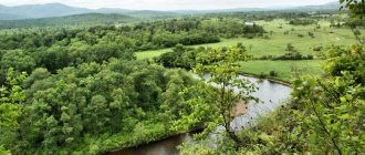
The vegetation cover in the Yamal-Nenets Autonomous Okrug has a pronounced latitudinal zonation. Five landscape zones can be distinguished: northern taiga, forest-tundra, shrub, moss-lichen and arctic tundra. In the northernmost, arctic zone, vegetation is very sparse. Here you can only find mosses, lichens and sedges. Small bushes and herbs are already growing in the moss-lichen tundra. In the next zone (shrub tundra) dwarf birches and willows grow, and berries and mushrooms grow along the rivers. There are many swamps and small rivers in the forest-tundra. Dwarf birches, larches, and small spruce trees grow here. In the southernmost zone of the Yamalo-Nenets Autonomous Okrug - the taiga, there are many lakes, swamps, and rivers. The entire territory is covered with dense light and dark coniferous forests.
Mineral natural resources
The Yamalo-Nenets Autonomous Okrug (capital Salekhard) is famous for its hydrocarbon reserves. About 78% of the total reserves of Russian oil and gas are concentrated here. The Yamal-Nenets Autonomous Okrug is the world's largest hydrocarbon resource base. Developments for the extraction of valuable raw materials are being carried out at the Nakhodka and Urengoy gas fields, Ety-Purovskoye, Yuzhno-Russkoye, Yamburgskoye oil fields. In the Yamal-Nenets Autonomous Okrug, about 8% of the total production of “black” and about 80% of “blue gold” is produced annually. In the Polar Urals, chromium, molybdenum, tin, iron, lead, phosphorites, barites and other minerals are mined.
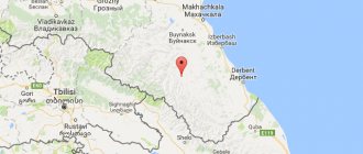
MEETING PLACE OF TWO CONTINENTS
Three kilometers east of the Polar Ural station, at the 97th kilometer from the city of Labytnangi, near the railway track, a Europe-Asia sign was installed in 1955. But the dispute over where the border actually lies is not over.
Not long ago, scientists announced another version: the border runs along Mount Gerd-Iz - translated as “red”. It is only 30 minutes' drive from Kharp, and from above you can clearly see the meeting of two continents. Using inconspicuous peridotite stones, scientists have found the answer to where Europe ends and Asia begins. According to experts, the rocks of the European continent are more ancient, they are darker, and the Asian continent is characterized by a yellow color. This unique “window to Europe” is quite worthy of the title of a new brand of Yamal, northerners believe.
Indigenous peoples of the Yamalo-Nenets Okrug
Today twenty peoples live in the Yamal-Nenets Autonomous Okrug. But the true indigenous inhabitants are the Khanty, Nenets, Selkup and Komi-Izhemtsy, who have lived in this territory since time immemorial. The rest settled only in the second half of the twentieth century. This is due to the development of the territories of the Far North during the era of the Soviet Union.
Khanty: this people have lived since ancient times in the territories of the Khanty-Mansiysk and Yamalo-Nenets Autonomous Okrug. The culture, language and customs of this people are very heterogeneous. This is due to the fact that the Khanty settled over a fairly vast territory and therefore became somewhat scattered.
The Nenets inhabit a vast territory of Russia - from the Taimyr Peninsula to the coast of the Arctic Ocean. These people migrated from southern Siberia in the first millennium AD. He belongs to the Samoyed group.
It is known that the Komi people have lived in this territory since the 1st millennium BC. This people is divided into northern and southern Komi. From time immemorial, the first people were engaged in reindeer herding, fishing and hunting. The second were hunters and fishermen.
The Selkups are the most numerous people of the North. The Selkups traditionally engaged in fishing and hunting. Those representatives of the people who lived at higher latitudes also bred deer.
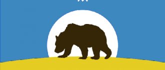
Heraldry of Salekhard
The official coat of arms of Salekhard is laconic, restrained, and strict. It is based on a French shield common to heraldry. The only symbolic image on the shield is a fox walking with its tail raised up and scarlet eyes; A scarlet tongue peeks out of its mouth.
The color scheme of the coat of arms is as strict as the image itself. Only three colors are used:
- Silver: the background of the shield, the shirtfront on the fox’s chest, its belly, the tips of its paws and tail.
- Black: fox.
- Scarlet (red): tongue and eyes.
The history of the existence of the heraldic sign dates back to 1731, when the coat of arms was granted to Obdorsk by Empress Anna Ioanovna. The image of the fox repeated the symbolism and color scheme of the historical symbol of the Siberian Principality of Obdorsk in the 17th century, with the only difference: in the historical version, the fox held an arrow in its paws.
The image of a fox as a symbol was not chosen by chance: this predatory animal, the silver fox, symbolizes the main occupation of the indigenous peoples of the Urals - hunting.
Administrative center
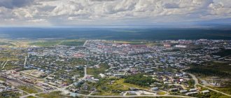
The capital of the Yamal-Nenets Autonomous Okrug is the city of Salekhard. It was located on the bank of the Ob (on the right side). The city is located on the Arctic Circle (the only one in the world). The population is about 40 thousand people. The city was founded in 1595. At first it was a small fort called Obdorsky. Half a century after its founding, permanent residents appear here. Since 1923, the village of Obdorsk has become the center of the Obdorsky district of the Ural region. And already in 1930, the village was given the status of the administrative center of the Yamalo-Nenets Autonomous Okrug. Three years later, Obdorsk was renamed Salekhard. Nowadays, the Yamalo-Nenets Autonomous Okrug, the capital of the Autonomous Okrug in particular, is developing at a fairly rapid pace. There are many enterprises in the city: Yamalzoloto, a river port, a fish canning factory and others. The Yamal-Nenets District Museum and Exhibition Complex has been opened in the city, which houses an exhibition center, a local history museum and a scientific library. Also in Salekhard is the District House of Crafts, a state budgetary cultural institution of the Yamalo-Nenets Autonomous Okrug. There are many branches of various universities in the capital of the Yamal-Nenets Autonomous Okrug. It should be noted that the Yamalo-Nenets Autonomous Okrug (capital Salekhard) is experiencing great problems with Internet access. The fact is that there is no fiber optic network in the region yet.
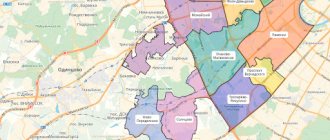
Cities and districts of the Yamalo-Nenets District
The Yamal-Nenets Autonomous Okrug consists of seven districts, eight cities, five urban-type settlements and forty-one rural administrations. Districts of the Yamalo-Nenets Autonomous Okrug: Yamalsky, Shuryshkarsky, Tazovsky, Purovsky, Priuralsky, Nadymsky and Krasnoselkupsky. As mentioned above, the population density is very low. Despite the vast territory, there are very few cities in the Yamalo-Nenets Autonomous Okrug. Cities: Noyabrsk (97 thousand), Novy Urengoy (89.8 thousand), Nadym (45.2 thousand), Muravlenko (36.4 thousand), Salekhard (32.9 thousand), Labytnangi (26, 7 thousand), Gubkinsky (21.1 thousand inhabitants). Some cities of the Yamal-Nenets Autonomous Okrug will be described in more detail below.
Gubkinsky
The city of Gubkinsky (Yamalo-Nenets Autonomous Okrug) became a city of district significance in 1996 and was named after the Soviet geologist Ivan Mikhailovich Gubkin. It is located on the left bank of the Pyakupur River, two hundred kilometers from the Arctic Circle. This city was formed as a base center for the development of oil deposits. Therefore, Gubkinsky (Yamalo-Nenets Autonomous Okrug) mainly specializes in the oil and gas production and processing industries. The city does a good job of working with young people: there are sports and cultural centers, a dance school, and a recording studio. Young people have the opportunity to get an education in their hometown.
The sculptural world of Salekhard
The sculptural world of Salekhard is unusual. There are a large number of monuments dedicated to animals that embody the sacred spirits of the indigenous inhabitants of Yamal:
- Near the ferry crossing there is a 10-meter mammoth. More than 40 extinct mammoths have been found in northern Siberia, among them the Yamal mammoths Masha and Lyuba.
- On the embankment of the Shaitanka River there is a six-meter monument to the reindeer - the main wealth of the tundra, a symbol of goodness and immortality.
- The bypass road is crowned with a sculptural composition dedicated to the Siberian Cranes - white Siberian cranes, a sacred bird of the indigenous peoples of the North, bringing happiness to everyone who sees it.
- Near the Polaris cinema there is a small sculpture perched - a dragonfly immortalized in stainless steel.
- In the center of the waiting room at Salekhard airport, tundra swans seem to be trying to take off - a symbol of returning to their native land.
- Near the building of the Arctic Hotel, a bear and a bear cub, carved from granite, represent a 10-ton “Constellation” composition.
- Near the airport, two bears froze on snow-covered ice floes. They support the shield “Coat of Arms of Yamal in a Crown”. This is a vivid image of the connection between people and nature in the Arctic.
- The entrance to Salekhard is marked by a stele of the same name, depicting the inhabitants of the aquatic, celestial and terrestrial spaces of the Arctic coast: seagulls, walruses and bears reflect the natural world of Yamal.
Noyabrsk. Yamalo-Nenets Autonomous Okrug
After Novy Urengoy, Noyabrsk is the second most populous city in the Yamal-Nenets Autonomous Okrug. The founding date of the city can be considered 1973, when the first oil well was drilled on the site of present-day Noyabrsk. Two years later, the first settlers arrived here, who mainly consisted of workers. Back in 1976, the village of Noyabrsk could only be found on oil workers’ maps, and already in 1982 the village was given the status of a district town. The oil and gas and fuel industries are very well developed. More than thirty companies operate in this field.
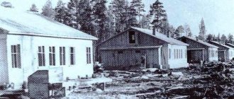
SIBERIAN TROY
Mangazeya is the first Russian polar city of the 17th century in Siberia. It was located on the Taz River at the confluence of the Mangazeika River. There were legends about the wealth of the city; the name “boiling gold” was firmly attached to Mangazeya; it was an extremely rich trading and merchant city, where goods and gold were traded in large volumes and quickly in terms of transaction times, bringing fabulous profits.
In cultural, historical and geographical aspects, Mangazeya partly repeated the fate of Troy: over time, Mangazeya began to be considered a legendary city that never really existed.
In 2021, oil workers, with the support of the Russian Geographical Society, conducted a historical and geographical reconstruction of the journey of domestic pioneers of the Far North “The Secret of Mangazeya - 2019”.