Mtsensk is the only ancient city in Russia that has the official status of a single-industry town. The 1990s dealt a heavy blow to its economy. The city-forming enterprises - the Mtsensk aluminum casting plant (a branch of the Soviet auto giant ZIL) and the secondary non-ferrous metals plant have died a long life. As a result, thousands of highly qualified specialists found themselves out of work.
In April last year, the city managed to receive the status of a territory of advanced socio-economic development (ASED) “Mtsensk”. Thus, the regional and city leadership are trying to overcome the consequences of the industrial failure of the 90s and give the ancient city a new life. However, until now, few people, including local residents, understand what a PSEDA is.
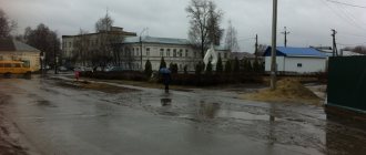
And on January 31, an explosion occurred at the Professional Equipment Plant, which is part of the TASED, which led to the death of 5 workers. This emergency predictably increased the local population’s suspicion of everything that happens in the PSEDA.
Correspondents from the Federal News Agency went to the site to understand what a territory of rapid socio-economic development is in practice and how it can improve life in the city.
Historical facts
Mtsensk is one year older than Moscow itself. Residents of the city never tire of reminding every tourist about this.
- 1146 - the first mention in the Nikon Chronicle of the city, which was part of the Chernigov principality.
- In 1238 it was destroyed by the hordes of Batu.
- Since 1246 - as part of the Novosilsk principality.
- Since 1320 - under the rule of the Grand Duchy of Lithuania.
- In 1492, the city was conquered by the Russian army under the leadership of governor Theodore Obolensky.
- 1505 - Mtsensk territorially belongs to the Moscow state.
- In the 16th-17th centuries, the Mtsensk fortress became one of the largest military fortifications on the southern borders.
- Since 1708, the city has been part of the Kyiv province, since 1719 - the Oryol province, since 1727 - the Belgorod province.
- Since 1778 - a district town of the Oryol governorship, and since 1796 - of the Oryol province.
- In 1868, a branch of the Moscow-Kursk road that was being built passed through the city.
- In October 1919 it was captured by the White Guards, who soon retreated. Mtsensk became the extreme point of the campaign against Moscow.
- Since 1925 it has been declared a city, since 1928 - the center of the district of the Oryol region.
- In 1943, bloody battles took place for Mtsensk; on July 20, the city was liberated by units of the Bryansk Front.
- Since 1963 it has belonged to the settlements of regional subordination, and since January 2006 it has been a district of the “City of Mtsensk”.
For young people the road to TASED
Like many cities located in relative proximity to Moscow, the pressing question for Mtsensk is how to keep young people from moving to the capital and other megacities.
“Skilled workers who once left to work in Moscow are gradually returning to us,” says the head of Mtsensk. “Of course, this makes us happy.” But now the investors who have come to us are asking that we prepare young specialists for the specific needs of TASED residents during the training process.”
Federal News Agency / Stepan Yatsko
And the region is meeting entrepreneurs halfway. Projects are already being developed to create a new campus , which is a system of end-to-end education from school to science and production. In particular, the governor of the Oryol region, Andrei Klychkov, spoke about this in an interview with the Federal News Agency.
“One of our residents is the AURUS enterprise, which will process secondary raw materials - household appliances, computers, etc. into plastic, copper and precious metals. They have modern European equipment and, of course, they are interested in young specialists who are familiar with various digital technologies,” says Andrey Belyaev.
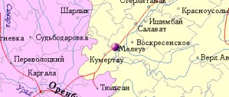
Mtsensk on the map of Russia: geography, nature and climate
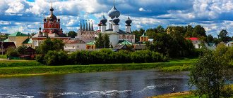
The city is located on both banks of the Zusha River at a distance of 56 km from the regional center. On the high left bank there is the old part with ancient churches and a railway station.
Modern microdistricts and city administration are located on the gently sloping right bank. The urban development area is about 21 square meters. km, in the north-south direction Mtsensk stretches for 8 km, in the east-west direction - for 4.7 km.
Mtsensk on the map of Russia is located in the middle zone with a temperate continental climate. Winters here are snowy and cool, but thaws often occur. Summers are hot, with infrequent thunderstorms and warm showers. Cloudy off-seasons last a long time and are characterized by prolonged drizzling rains.
Sights of Mtsensk
Tourist interest in the provincial town is associated primarily with ancient temples.
- The Peter and Paul Monastery has existed since the 16th century, but to this day only the Church of the Sign and a residential building with monastic cells have survived.
- The funeral cortege with the body of Emperor Alexander I, who died suddenly in Taganrog, stopped at the Nikitskaya Church
- The Church of the Ascension is located on the site of a convent that burned down at the end of the 17th century. It was almost demolished during the construction of the Simferopol highway, but some official read that the temple was previously considered the home church of one of A.S. Pushkin’s ancestors, and this fact saved the shrine.
- Upstream the Zushi the St. George's Fortress , and on the site of the St. Nicholas Cathedral that disappeared after the explosion, a small chapel was recently erected.
- the holy spring of John the Baptist gushes out of the ground , near which pilgrims always gather.
Mtsensk is famous for its lace, which is not inferior in beauty to Vologda. The products of city craftswomen were delivered to the emperor's court and won awards at prestigious exhibitions in Glasgow and Paris. The best samples make up the exhibition of the Lace Museum.
The names of many Russian writers are associated with the Mtsensk district - I.S. Turgenev, A. Fet, who were born near the town, as well as N. Leskov, N. Nekrasov, Leo Tolstoy, N. Karamzin, M. Lermontov, who visited the city. Their work recalls these places. A map of Mtsensk with streets will tell the tourist how to find objects of interest.
Trinity Church (1777). Photo: NordprodTime for inspection: 2-3 hours.
Why go to Mtsensk: preserved buildings and architectural monuments of the 17th-19th centuries. Beautiful location of the city and landscapes of the south of the middle zone. Near the city there is Spasskoye-Lutovinovo - the State Museum-Estate of Ivan Sergeevich Turgenev.
Orientation: The historical center of Mtsensk is located on the left (high) bank of the Zushi. There is a settlement, the former Peter and Paul Monastery and three more churches. There is a railway station on the same bank. The modern administrative center of the city is located on the right (low) bank of the Zushi. There are also remains of old buildings there. After the war, the destroyed city was not restored, and now the surviving architectural monuments in the center are adjacent to five-story buildings. The bus station is located on the right bank (Turgenev Street), at a fairly large distance from the railway station. You can get from one station to another by city bus route.
Approximate walking time:
- From the railway station to the bridge over Zusha - 15 minutes;
- From the bridge over Zusha to Khlebnaya Square (Lenin Square) - 10 minutes;
- From Khlebnaya Square (Lenin Square) to the bus station - 15 minutes.
Left Coast. The railway station building is also an architectural monument of the late 19th century. Next to it, a train consisting of a steam locomotive, a passenger carriage and a platform is preserved as a monument to the liberation of the city in 1943.
The Peter and Paul Monastery was founded as Petrovsky, most likely in the 16th century, immediately after Mtsensk joined the Moscow state, and in 1694 it was moved to its modern location, on the left bank of the Zushi below the city center, and renamed Petropavlovsky. In 1764, the monastery lands were confiscated, and the monastery was transferred to the category of supernumerary, where it remained until 1819, when it was incredibly lucky: the episcopal see was transferred from Sevsk to Orel, and the Assumption Monastery was appointed the bishop's residence. Accordingly, the entire population of the Assumption Monastery was transferred to the Peter and Paul Monastery, with the status of the latter being increased. In 1923, the monastery was closed and used as a prison. Naturally, he suffered greatly from such use. Only the Znamenskaya Church (1813-1821), badly damaged and deprived of its finishing, has survived, as well as the cell building in ruins and the remains of the fence. The church was recently handed over to believers, but the monastery has not been restored. The monastery is located directly next to the railway station (Privokzalnaya Street, 11).
We return to the station and turn towards the city center along Andrei Reva Street. The street runs along Zushi at some distance from the river. If you turn along Protasovskaya Street and walk to the river bank, you will have a good view of the Trinity Church on the other bank (see below). Even further, Andrei Reva Street abuts a perpendicular street, which crosses Zusha on the left over a bridge and goes out into the right bank part of the city, where it is called Mira Street. On the right it crosses the railway and goes straight to Bolkhov, and to the left - to Orel. A little to the left of the intersection is the Ascension Church (late 17th century). At this site there was once a convent of the Ascension for women, founded in 1662, completely burned down in 1695 and closed in 1764. The surviving church was the first stone building in the monastery, built immediately after the fire of 1695. The church was closed in 1938 and was heavily damaged by shelling during the war; Moreover, in 1945 it was almost demolished during the construction of the Simferopol highway, but it was saved by passing it off as the “house of boyar Pushka,” Pushkin’s fictitious ancestor. The church is now active.
Three more churches are located upstream. First we will go along the railway tracks. The right (farthest from the river) path is hardly used (be careful when crossing the other two!!). To the right, behind the railway, is the Classicist Church of St. George (1825) in ruins. On the left, first we will see a high hill on which the St. Nicholas Cathedral once stood, blown up in the 1930s; in its place in 1996, the red-brick chapel of St. Nicholas the Wonderworker was erected. Even further, on the site where the Petrovsky Monastery stood until 1694, the five-domed Vvedenskaya Church with a bell tower (1670s) has been preserved. Although the church was closed in the 1930s, it was returned to the faithful in 1947 and is now in fair condition. Behind the church we will cross the railway again, along Zakharyev Street we will go back to the Church of the Presentation and the chapel of St. Nicholas the Wonderworker, then along the path along the high bank of the Zushi, from which views of the right bank open up, to the Church of the Ascension and to the bridge over the river. From the bridge there is a wonderful panorama of the high left bank of the river.
Photo: Nordprod
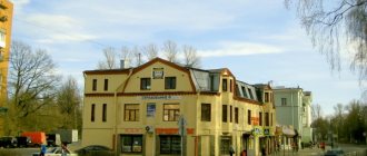
Right bank. There was once a settlement here, but over time, when the defensive importance of Mtsensk faded away, the administrative center of the city moved here. Directly next to the bridge, on the right, is the former Red Square with the Resurrection Church (1802) preserved in ruins. The center of the city for the last two hundred years has been Khlebnaya Square (Lenin Square), on which shopping arcades have been preserved (early 19th century, architect Popov), after recent restoration they were repainted in a poisonous yellow color. Mira Street leads from the bridge to Lenin Square. In the right bank part, many architectural monuments have been preserved, but you will have to look for them among modern buildings. The easiest way is to go to Lenin Square along Lenin Street, also going left along Sovetskaya Street to the Trinity Church and back, and right along Karl Marx Street to the Church of the Exaltation of the Cross and back. Trinity Church (1777, Sovetskaya Street, 56, early 19th century bell tower) was built in a clearly identifiable Baroque style and is in good condition. On the way to it we will pass the building of the former city school (19th century, Sovetskaya Street, 34). The Church of the Exaltation of the Cross (1818, Karl Marx Street, 30 - corner of Karl Marx and Pionerskaya streets) served as a cathedral before the construction of St. Nicholas Cathedral. In particular, after the sudden death of Alexander the First in 1825 in Taganrog, his body was taken to St. Petersburg, and for three days (January 23-25, 1826) it remained in the Church of the Exaltation of the Cross in Mtsensk. The temple is operational, although dilapidated and being restored.
Most of the surviving monuments of civil architecture of Mtsensk are located on Mira Street between Karl Marx Street and Lenin Square, and especially on Lenin Street between Sovetskaya Street and Lenin Square, where the buildings of the 18th-19th centuries have been completely preserved. At number 10 there is a merchant's house (now there is a department of the Internal Affairs Directorate), in which, according to tradition, lived a woman who was the prototype of Katerina Izmailova, the heroine of the story Lady Macbeth of Mtsensk. Like other urban legends, this one must be treated with caution - in fact, there was no clear prototype, Leskov lived in Orel, and in Mtsensk, although there was a house of the Izmailov merchants, it was not this one, but another one, long destroyed. Another famous house, repeatedly mentioned by Afanasy Fet, is the house with lions (house 5, late 18th century), which now houses the military registration and enlistment office. The lions are not at the gate, as one might expect, but in the form of small heads on the wall of the estate.
To the east of Lenin Square (further from the river) there is the former cemetery Church of the Transfiguration (1845) in ruins. At the exit from Mtsensk towards Moscow (end of Turgenev Street) there is a Katyusha installation in the form of a monument to the liberation of the city.
Museums
Mtsensk City Museum of Local Lore named after Georgy Fedorovich Solovyov. Address: Turgenev street, 104 (near Lenin Square). Opening hours 10-18, closed Monday and last Thursday of the month. Phone (486-46) 2-50-49. Collections on the history of Mtsensk (with a large share of the Soviet period), as well as folk art (including lace).
Mtsensk Art Gallery. Address: Kuzmina street, 1a. Phone (486-46) 3-10-75, 3-45-54. Works by contemporary artists. There is a suspicion that the Lace Museum, opened in 1999, mentioned in various publications, is in fact an Art Gallery.
Districts and main streets of Mtsensk
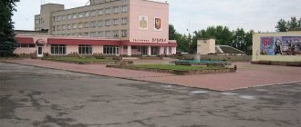
One of the main streets of the city is Bolkhovskaya, which, near the Pyaterochka supermarket, turns into Mira Street, which runs past the Park of Culture and Recreation, Sberbank, the Jam supermarket, the Oblaka cinema and Lenin Square, ending near the First Guards Tankmen's Square on Turgenev Street . Along the latter there is the Mtsensk city park, a local history museum, a Magnit supermarket, a bus station, and a branch of the OSU.
Gagarin, Sovetskaya, and Karl Marx streets extend parallel to it, and Lenin Street runs through residential areas of the private sector with modern buildings closer to the outskirts.
Highway Street stretches from industrial areas and goes out onto the Crimea highway.
Unusual in the city is Kuzmina Street , which flows from Karl Marx Street and branches into several “sleeves”. A map of Mtsensk with houses will indicate where a specific building is located.
Mtsensk
(Oryol Region)
OKATO code:
54410
Founded:
1146
City since:
1146 City of regional subordination
Center:
Mtsensk district
Telephone code (reference phone)
| 48646***** | 25-9-29 |
Deviation from Moscow time, hours:
0
Geographic latitude:
53°17′
Geographic longitude:
36°34′
Altitude above sea level, meters:
160 Sunrise and sunset times in the city of Mtsensk
Economy and industry of the city of Mtsensk
In Mtsensk there are several producing equipment and machinery for public utilities, Mezhgosmetiz-Mtsensk, which produces welding materials, an Orlovskaya Krepost alcohol distillery, and a furniture factory. The financial sector is represented by branches of Sberbank, Sovcombank, Rosselkhozbank, Mutual Assistance, Trust and others. Healthcare institutions include a district hospital, a drug treatment clinic and a blood transfusion station.
West of Mtsensk there is a real ski resort with 10 ski lifts and buildings of the Mtsensk boarding house.
The oldest city in Russia, Mtsensk, is able to surprise the demanding tourist and leave pleasant memories of the trip.