Sights of Salekhard
The city of Salekhard at present. It is the administrative center of the Yamalo-Nenets Autonomous Okrug. Geographically, it is located on the Poluy Upland of the West Siberian Plain, at the confluence of the Poluy River and the Ob.
This is the only city not only in our country, but also in the world, which is located on the Arctic Circle. Therefore, the polar day in Salekhard lasts from June 7 to July 7—31 days.
In this case, the upper edge of the sun does not fall below the horizon. Twilight nights last from April 4 to September 9 - 159 days. There are no polar nights in Salekhard. Northern lights are a common sight in this city.
General information
The population of the city is 51 thousand people. Salekhard is a multinational city, but more than 60% of the population are Russians.
The city has food industry enterprises, as well as PJSC Yamalzoloto, OJSC Salekhard River Port and CJSC Yamalflot.
The easiest way to get to Salekhard is by plane; there is an airport in Salekhard. In summer there is a ferry crossing, and in winter there is an ice crossing across the Ob to the nearest town of Labytnangi. In 1949-1953, construction of the Transpolar Railway began from Salekhard. But after Stalin's death the project was mothballed. Now there are new projects for the construction of two polar railway lines - Salekhard-Nadym and Polunochnaya-Obskaya-Salekhard. But these projects have not yet been implemented either. In Salekhard itself there is an ATP, with five city bus routes. The city has five secondary schools, a college and an agro-economic polar technical school.
The city of Salekhard is developing mainly with the help of Gazprom. If the old part of the city consists mainly of one-story and two-story barracks, then in the new buildings there are already many multi-story and beautiful modern buildings.
In 2014, Rostelecom put into operation the Northern Optical Stream - this is a backbone communication line from Yekaterinburg to Salekhard (via Khanty-Mansiysk, Surgut, Noyabrsk, Novy Urengoy). So there is Internet in Salekhard.
City information
Salekhard is the administrative center of the Yamalo-Nenets Autonomous Okrug of the Russian Federation. It is located on the banks of the Poluy and Ob rivers, near the Polar Urals. The economy is represented by enterprises of the petrochemical, mining, processing, transport, and food industries. There are companies in the service and trade sectors.
There are no major highways passing through the settlement. There is a ferry service from the river port. There is a civil airport of the same name. There are vocational educational institutions and branches of universities. Located in harsh climatic conditions.
Details
Historical reference
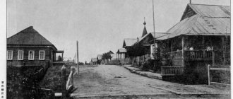
In 1595, the Cossacks founded the Obdorsk fortress, or Ostrog in other words, on the site of present-day Salekhard. In 1635, the settlement began to be called Obdorskaya Zastava. It was the northernmost settlement in Siberia. After the fortifications were removed in 1807, Obdorsk became an ordinary village.
It was the center of the Obdorsk volost of the Berezovsky district of the Tobolsk province until 1923. Since November 1923, Obdorsk became the center of the Obdorsky district of the Ural region. In 1930 it became the center of the Yamal National Okrug, in 1933 - the regional village of Salekhard, and in 1938 it received the status of a city.
At different times they were sent to the city of Salekhard to serve exile. After the revolution, many church hierarchs served their sentences there. In 1990, Salekhard was included in the list of historical cities of Russia.
Map
| Salekhard: maps |
Salekhard: photo from space (Google Maps) Salekhard: photo from space (Microsoft Virtual Earth)
| Salekhard. Nearest cities. Distances in km. on the map (in brackets along roads) + direction. Using the hyperlink in the distance , you can get the route (information courtesy of the AutoTransInfo website) | |||
| 1 | Labytnangi | 16 () | NW |
| 2 | Harp | 47 () | NW |
| 3 | Aksarka | 51 () | IN |
| 4 | Husbands | 152 () | SW |
| 5 | Vorkuta | 155 () | NW |
| 6 | Northern (Komi Republic) | 161 () | NW |
| 7 | Vorgashor (Komi Republic) | 169 () | NW |
| 8 | Yar-Sale | 187 () | IN |
| 9 | Nadym | 287 () | SE |
| 10 | Inta | 295 () | Z |
| 11 | Berezovo (Khanty-Mansiysk Autonomous Okrug - Ugra) | 298 () | YU |
| 12 | Beloyarsky | 313 () | YU |
| 13 | Pangodas | 360 () | IN |
| 14 | Igrim (Khanty-Mansiysk Autonomous Okrug - Ugra) | 386 () | YU |
a brief description of
Located on the Poluyskaya Upland, on the right bank of the Ob at the confluence of the river. Poluy, near the Arctic Circle, 1982 km north of Tyumen, 2436 km northeast of Moscow. Located in the zone of distribution of perennial rocks.
Nearest railway Labytnangi station - 20 km from Salekhard, on the opposite bank of the Ob (connected with Salekhard in the summer by a river tram, in the winter - by bus). River port.
The climate is sharply continental and harsh. Average temperatures in January are from -22 to -26, in July +4 +14. Precipitation is 200-400 mm per year.
Territory (sq. km): 1018
Information about the city of Salekhard on the Russian Wikipedia site
Historical sketch
Founded in 1595 as a Cossack fortress (at that time the northernmost in Siberia) called Obdorsk (the Nenets name of the village is Sale-Kharn, i.e. “settlement on a cape” from sale “cape”, hard “house, settlement” ). Obdorsk - “place near the Ob”; Komi “dor” in geographical names “a place next to something” - guides of Russians in the 16th century. were Komi.
At the end of the 18th century. the fortress was abolished. Since the 1820s, Russians began to settle permanently in Obdorsk. From the middle of the 18th to the beginning of the 20th century. the annual winter Obdorsk fair took place here (from December 15 to January 25). During the fair, the population of Obdorsk increased to several thousand people. Russian merchants (mainly from Tobolsk) brought flour, bread, wine, cloth, iron and copper products, and jewelry; in return they received furs, fish and fish glue, mammoth bone, and walrus tusks.
In the 1740s. Obdorsky town in the Tobolsk province of the Siberian province.
In 1807, the fortifications were demolished, Obdorsk became a village. Until the end of 1923, it was part of the Berezovsky district of the Tobolsk province. Since November 3, 1923, the center of the Obdorsky district of the Ural region. Since 12/10/1930 - the center of the Yamal (Nenets) national district.
In 1897, there were 30 houses and 150 shops in Obdorsk. The inhabitants were mainly engaged in hunting, fishing and trading. In 1897, a fishing school was founded.
On June 20, 1933, it was transformed into a workers' village called Salekhard. City of Salekhard since November 27, 1938
Municipal indicators
| Index | 1990 | 1999 | 2001 | 2003 | 2005 |
| Demography | |||||
| Number of births, per 1000 population | 17 | 14.5 | 13.7 | 15.6 | 15 |
| Number of deaths, per 1000 population | 5.7 | 8.6 | 10.5 | 8.5 | 8 |
| Natural increase (decrease), per 1000 population | 11.3 | 5.9 | 3.2 | 7.1 | 7 |
| Standard of living of the population and social sphere | |||||
| Average monthly nominal accrued wages, rub. | 0.499 | 4412 | 9093 | 16013 | 22805.5 |
| Average housing area per inhabitant (at the end of the year), sq.m. | 13 | 18.4 | 20.2 | 20.7 | 21.4 |
| Number of preschool institutions, pcs. | 28 | 19 | 17 | 17 | 18 |
| Number of children in preschool institutions, thousand people | 3.2 | 2 | 1.9 | 2.2 | 2 |
| Enrollment of children in preschool educational institutions (at the end of the year), as a percentage of the number of children of the corresponding age, % | 78.6 | 69.9 | |||
| Number of daytime educational institutions (at the beginning of the school year), pcs. | 8 | 9 | 9 | 9 | 9 |
| Number of students in daytime educational institutions, thousand people | 5.3 | 5.7 | 5.5 | 5.5 | 5.4 |
| Number of doctors, people. | 203 | 282 | 326 | 369 | 541 |
| Number of nursing staff, people. | 703 | 752 | 790 | 898 | 1103 |
| Number of hospital institutions, pcs. | 6 | 8 | 9 | 10 | 9 |
| Number of hospital beds, thousand units | 0.8 | 0.9 | 1.1 | 1 | 0.9 |
| Number of medical outpatient clinics, pcs. | 7 | 8 | 9 | 8 | 10 |
| Capacity of medical outpatient clinics, visits per shift, thousand units. | 1.2 | 1 | 1 | 1 | 1 |
| Number of registered crimes, pcs. | 458 | 974 | 1011 | 952 | 1535 |
| Persons who committed crimes were identified, persons. | 257 | 531 | 550 | 451 | 760 |
| Economy, industry | |||||
| Number of enterprises and organizations (at the end of the year), pcs. | 763 | 954 | 402 | 741 | |
| Number of operating enterprises by type of activity: mining (at the end of the year), pcs. | 1 | ||||
| Number of operating enterprises by type of activity: manufacturing (at the end of the year), pcs. | 22 | ||||
| Number of operating enterprises by type of activity production and distribution of electricity, gas and water (at the end of the year), pcs. | 8 | ||||
| Volume of shipped goods of own production by type of mining (in actual prices), million rubles. | 15 | ||||
| Volume of shipped goods of own production by type of manufacturing (in actual prices), million rubles. | 187.2 | ||||
| Volume of shipped goods of own production by type of production and distribution of electricity, gas and water (in actual current prices), million rubles. | 1068.3 | ||||
| Construction | |||||
| Volume of work performed by type of activity “Construction” (until 2004 - volume of work performed under construction contracts), million rubles. | 338.2 | 1691.3 | 1882.2 | 731.3 | |
| Commissioning of residential buildings, thousand sq.m. of total area | 13 | 1.3 | 53.6 | 22.3 | 42.5 |
| Commissioning of residential buildings, apartments | 10 | 767 | 255 | 671 | |
| Commissioning of preschool institutions, places | 0 | 0 | 0 | 0 | 0 |
| Commissioning of educational institutions, places | 0 | 0 | 0 | 800 | |
| Commissioning of hospital facilities, beds | 60 | 0 | 0 | 0 | 250 |
| Commissioning of outpatient clinics, visits per shift | 100 | 0 | 0 | ||
| Transport | |||||
| Number of bus routes (in intracity traffic), pcs. | 4 | 6 | 5 | 5 | |
| Number of passengers transported by buses per year (in intracity traffic), million people. | 2.8 | 2.6 | 1.6 | 1.9 | |
| Connection | |||||
| Number of telephone sets of the city public telephone network, thousand units. | 5.9 | 11.1 | 13.2 | 15.5 | 16.6 |
| Number of residential telephone sets of the city public telephone network, thousand units. | 3.4 | 7.7 | 8.8 | 10.1 | 10.8 |
| Number of payphones of the city telephone network (including universal ones), pcs. | 43 | 58 | |||
| Trade and services to the population | |||||
| Retail trade turnover (in actual prices), million rubles. | 0.07 | 550 | 902 | 1395 | 2379.7 |
| Retail trade turnover (in actual prices), per capita, rub. | 2.2 | 16859 | 26934 | 37291 | 61018.7 |
| Index of physical volume of retail trade turnover, % compared to the previous year | 111 | 118 | |||
| Index of physical volume of public catering turnover, % compared to the previous year | 105 | 113 | |||
| Number of stores, pavilions (at the end of the year), pcs. | 5 | 4 | |||
| Sales area of shops, pavilions (at the end of the year), sq.m. | 205.6 | 1011 | |||
| Volume of paid services to the population (in actual prices), million rubles. | 0.011 | 222.1 | 397.1 | 1309.6 | 2013.3 |
| Volume of paid services to the population (in actual prices), per capita, rub. | 0.3 | 6812 | 11853 | 35017 | 51622.6 |
| Volume of household services to the population (in actual prices), million rubles. | 0.002 | 27.6 | 36.8 | 51.6 | 71.7 |
| Volume of household services to the population (in actual prices), per capita, rub. | 0.1 | 848 | 1100 | 1381 | 1838.6 |
| Investments | |||||
| Investments in fixed assets (in actual prices), million rubles. | 0.108 | 2025 | 3385.1 | 5221.8 | 4828.1 |
| Share of investments in fixed assets financed from budgetary funds in the total volume of investments, % | 89.1 | 95.1 | 87.8 | 68.5 | |
Data sources:
- Regions of Russia. Main characteristics of the constituent entities of the Russian Federation: statistical collection. Goskomstat of Russia. - M:, 2003.
- Regions of Russia. Basic socio-economic indicators of cities. Statistical collection. Rosstat. - M:, 2005. p. 281
- Regions of Russia. Basic socio-economic indicators of cities. 2006. Statistical collection. Rosstat. - M:, 2006. p. 277
Economy
Fish canning plant, dairy plant, house-building plant. Timber transshipment base.
Main enterprises
FISHING INDUSTRY
JSC "Salekhard Fish Canning Plant"
626600, Yamalo-Nenets Autonomous Okrug, Salekhard, st.
Mayakovskogo, 19a Offers:
Canned fish, frozen fish, cold smoked fish, salted fish
AUTOMOBILE ECONOMY
Salekhard motor transport enterprise
, Yamalo-Nenets Autonomous Okrug, Salekhard, st.
Priozernaya, 4 Offers:
Passenger transportation
INLAND WATER TRANSPORT
JSC "Salekhard River Port"
629000, Yamalo-Nenets Autonomous Okrug, Salekhard, st.
Lenina, 7 Offers:
Transportation of dry cargo, oil cargo, passengers
ELECTRIC AND RADIO COMMUNICATIONS
OJSC "Yamalelectrosvyaz"
629000, Yamalo-Nenets Autonomous Okrug, Salekhard, st.
Matrosova, 2 Offers:
Culture, science, education
Salekhard is the organizational center of geological exploration expeditions.
Museum of Local Lore.
Universities of the city
Salekhard branch of the Tyumen State Agricultural Academy
629000, Yamalo-Nenets Autonomous Okrug, Salekhard, st. Respubliki, 36-a WWW: https://www.tgsha-sal.ru/
Salekhard branch of the Ural Institute of Commerce and Law
629003, Yamalo-Nenets Autonomous Okrug, Salekhard, st. Geologists, 4
Capital Academy of Finance and Humanities (Salekhard branch)
629008, Yamalo-Nenets Autonomous Okrug, Salekhard, st. Lenina, 54
Tyumen State University (Salekhard branch)
629008, Yamalo-Nenets Autonomous Okrug, Salekhard, st. Republic, 50
Branch of Tobolsk State Pedagogical Institute named after. DI. Mendeleev in Salekhard
629008, Yamalo-Nenets Autonomous Okrug, Salekhard, Yamalskaya st., 30
Branch of Tyumen State Oil and Gas University in Salekhard
629007, Yamalo-Nenets Autonomous Okrug, Salekhard, st. Sverdlova, 13
Museums, galleries, exhibition halls
Museum-apartment of L. Laptsui 629008, Yamalo-Nenets Autonomous Okrug, Salekhard, st.
Komsomolskaya, 40 apt. 1 Phone(s): (34922) 47-381 Website: https://www.mvk-yamal.ru/ Yamalo-Nenets District Museum and Exhibition Complex named after. I.S. Shemanovsky 629008, Yamalo-Nenets Autonomous Okrug, Salekhard, st. Chubynina, 38 Phone(s): (34922) 47-013 (answer) 47-025 (ex. bureau) Website: https://www.mvk-yamal.ru/
| Population by year (thousands of inhabitants) | |||||||
| 1897 | 0.5 | 1996 | 29.6 | 2008 | 41.6 | 2017 | 48.5 |
| 1939 | 12.8 | 1998 | 30.5 | 2010 | 43.4 | 2018 | 49.2 |
| 1959 | 16.6 | 2000 | 32.7 | 2011 | 42.5 | 2019 | 50.1 |
| 1967 | 19 | 2001 | 33.2 | 2012 | 44.3 | 2020 | 51.0 |
| 1970 | 21.9 | 2003 | 36.8 | 2013 | 46.7 | 2021 | 51.2 |
| 1979 | 24.9 | 2005 | 38.3 | 2014 | 47.9 | ||
| 1989 | 32.3 | 2006 | 39.4 | 2015 | 48.3 | ||
| 1992 | 30.6 | 2007 | 40.3 | 2016 | 48.5 | ||
Cable-stayed bridge "Torch"
In Salekhard, like in many cities, there are several rivers and streams. The wide Ob River flows from the west of the urban area. The second most important river in Salekhard is the Poluy River, at the mouth of which the city itself was born. There are also very small rivers, like the Shaitanka. Its small valley separates the airport and the city streets. Salekhard city photo:
In December 2004, an unusual road bridge was built across Shaitanka. The cable-stayed structure with a tower rises 100 meters and has a length of 50 meters. The road laid here connects the airport with three microdistricts of Salekhard - Angalsky Cape, Combine and Hydroport.
At the top of the stylish bridge there is a catchy inscription “Yamal” and a two-story restaurant, from the windows of which a magnificent view of the city opens. Below there is a parking lot for 20 cars, and nearby there is a beautiful reindeer monument.
From a distance it seems that the bridge structure is unstable and is about to collapse. However, no need to worry! Everything is built conscientiously and verified by precise engineering calculations. The roadway is securely held above the river by strong cable stays. It's worth a look! A very unusual sight!
Geography and climate
Where Salekhard is located, the Poluyskaya Upland extends. The city is located on the right bank of the Ob. The capital of the Yamalo-Nenets Okrug is the largest gas producing region in the world. As noted above, the city is the only settlement on the entire planet located at the latitude of the Arctic Circle.
In terms of climatic conditions, Salekhard is located on the border of the temperate and subarctic zones. The climate here is harsh, sharply continental. Annual precipitation is approximately 500 mm, with 45% of the annual precipitation occurring in summer (July to August).
Attractions
Where is Salekhard? There, where churches of three religious denominations were erected - two Protestant churches (churches of Christian Baptists and Evangelism), a Catholic church, as well as the Peter and Paul Church, which is an Orthodox church.
There are also interesting historical buildings in the city:
- Ust-Poluy is a unique ethnographic monument (an ancient sanctuary), opened in 1932 and representing a crossroads of the most diverse cultures of the peoples of the north. It regularly hosts ethnographic festivals.
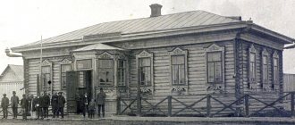
- The building of the Zemstvo Government, erected in 1901. It housed a police station, and later a hotel.
- The building of the regional committee of the All-Russian Communist Party of Bolsheviks is a landmark of the Soviet period. It was built in the style of socialist realism in 1933.
- The former theater of the 501st construction is a building made in the Stalinist Empire style. It housed the editorial office of the newspaper "Red North".
- The Kornilov (merchant) house, which is a historical and architectural landmark of Salekhard. It was built in 1895 and belonged to the Tobolsk merchant Kornilov, who was a shipowner. He used this building as a commercial building.
- Center for National Cultures, opened since 1987. Exhibitions of folk art by Salekhard craftsmen are held there.
Useful tips
— Be sure to take insect repellent with you and choose the most closed clothing possible—mosquitoes and midges are rampant in the tundra. Although at the beginning of autumn there are significantly fewer of them than in summer.
— It’s better to choose waterproof shoes—the area is swampy.
— A favorite vacation spot for Salekhard residents is Karchagi, which unites the Ob River with a sandy shore and a picturesque forest. They get there by car, or by taxi.
— The indigenous peoples of the North (Nenets, Khanty) treat the tundra and the land very carefully. Even traditional shoes are made in such a way as not to damage the soil. Remember - we are guests in the tundra and must behave respectfully.
Local color
Since ancient times, Yamal was inhabited by the Khanty, Nenets, Selkup, Komi - northern peoples who even today lead a nomadic lifestyle and preserve many traditions of the past. You can learn about their features by visiting the museum and exhibition complex named after I. S. Shemanovsky.
But it is much more interesting to visit an open-air museum - a natural and ethnographic complex. It is located in Gornoknyazevsk, 12 kilometers from Salekhard (15-20 minutes by car).
At the entrance to the museum grounds there is a birch tree, and a little further there is a larch tree. The first tree is sacred to the Komi and Khanty peoples, and the second is revered by the Nenets. Both trees are full of colorful ribbons and handkerchiefs - according to local beliefs, anyone who leaves a ribbon and a small souvenir can ask God for a blessing for their family.
Coming here, it’s as if you find yourself in a camp of real tents - the dwellings of the nomadic peoples of Yamal. You can go inside, look at the internal structure of the tent, sit on reindeer skins, and touch various utensils. You can even try on a yagushka (a woman’s fur coat) or throw a luxurious polar wolf skin over your shoulders, and take a closer look at a wonderful woman’s bag. These bags are simply gorgeous - made from smooth, shiny reindeer fur, decorated with bright Nenets patterns, and trimmed with fluffy white fox.
On the territory of the complex, deer are kept in a small corral. They have long been accustomed to tourists, they allow themselves to be petted and, according to the museum staff, “they have become awks,” i.e. tame deer. Here you can sit on a sledge (sleigh into which reindeer are harnessed), and hold a hunting bow in your hands.
The museum offers an extensive program: thematic excursions, fishing, reindeer sledding and snowmobiling, participation in ritual holidays, local delicacies. And in winter you can see an exhibition of ice sculptures.
Coat of arms
The coat of arms of Salekhard is presented in the form of a French shield. He reproduces the historical version.
On a silver background there is a black figure of a fox, facing to the left of the viewer. The animal is depicted with its right front paw and tail raised. Has scarlet eyes and tongue. The fox embodies a creature that is widespread in these parts.
The artistic composition was accepted on February 18, 1998 (as amended on December 9, 2004). Included in the State Heraldic Register of the Russian Federation under No. 229.
Monument to the mammoth
Near the Ob River, next to the ferry crossing that connects Salekhard and Labytnangi, a huge monument rises. The 10-meter-high monument can be seen from any part of the river. The figure of an extinct animal stands on a hillock. The place for it was chosen specifically so that the mammoth “Mitya” would be visible from a great distance.
In the stylized sculpture, the animal looks relaxed and good-natured. Its trunk hangs down, and its giant white fangs threaten no one. The original monument on the Ob bank appeared in the summer of 2005 and since then has turned into one of the iconic landmarks of Salekhard. His photo is easy to find in any city guide.
Many thousands of years ago, mammoths actually lived in the vicinity of Salekhard. “Mitya” symbolizes the animal that paleontologists dug up near the city. How old is he? Scientists suggest that it is a little less than ten thousand. The furry giants were classified as “polar mammoths.” To make it more convenient to break through high drifts of snow, they had closely spaced tusks.
All tourists try to take a memorable photo near Mitya. The hillock where the monument is erected is carefully looked after.