Administrative-territorial structure
According to the Law “On the administrative-territorial structure of the Primorsky Territory
"and the Register of administrative-territorial and populated localities of the Primorsky Territory, the subject of the Russian Federation includes the following administrative-territorial units:
- 12 cities of regional subordination, 5 intra-city districts (Vladivostok districts: Leninsky, Pervomaisky, Pervorechensky, Sovetsky, Frunzensky);
The administrative center of the region is the city of Vladivostok.
Municipal structure
As part of the municipal structure of the region, 118 municipalities were formed within the boundaries of the administrative-territorial units of the Primorsky Territory:
- 12 urban districts
- 3 municipal districts
- 19 municipal districts, on the territory of which there are 16 urban settlements and
- 68 rural settlements, as well as
- 2 inter-settlement territories.
As part of the administrative-territorial structure of the region, all municipal districts and municipal districts constitute administrative districts of the same name.
Economy and industry of Primorsky Krai
Thanks to its natural resources, location on the border of neighboring developed countries, as well as a large number of plants and factories, Primorye is a large industrial region. The regional economy is represented by such industries as:
- metallurgy;
- mechanical engineering;
- mining;
- energy;
- tourism;
- international trade.
Millions of tons of cargo are shipped annually from the ports of the region, which can be found on Yandex maps of the Primorsky Territory. Fishing makes a significant contribution to the economy of Primorye. Enterprises in the region also produce spare parts for cars, food, electricity and heat. Gold, diamonds and other rare minerals are mined in the region.
Tourism is of great importance for the region. Primorye has the largest reserves and hunting grounds. Tourists are offered river rafting, visiting natural and archaeological monuments, and hunting wild animals and waterfowl. Big cities welcome those arriving in the region with modern, comfortable hotels. Also in small settlements there are recreation centers for those who love active tourism.
Story
1856-1919. Primorsky region of the Russian Empire
1856-1880
On October 31 (November 14), 1856, in connection with the annexation of the Amur region to Russia from the coastal parts of Eastern Siberia, the Primorsky region of the East Siberian Governor-General was formed with the center in Nikolaevsk (see ATD of the Khabarovsk Territory)
.
In 1860, the Ussuri region, newly acquired under the Beijing Treaty, was annexed to the Primorsky region, which included the lands between the Amur, Ussuri and the Sea of Japan.
On February 10, 1871, by decision of the government, Vladivostok was established as the main military port of Russia on the Pacific Ocean. All naval institutions, the residence of the military governor and the main base of the Siberian military flotilla were transferred to Vladivostok from Nikolaevsk.
In September 1875, on the basis of the temporary regulation “On civil and military administration on the island. Sakhalin" The Sakhalin district of the Primorsky region was divided into two - Yuzhno-Sakhalin and North Sakhalin as part of the Primorsky region.
On April 28, 1880, Vladivostok with the Muravyov-Amursky Peninsula and Russky Island was separated from the Primorsky Region into an independent military governorate. The post of Khabarovka became the administrative center of the Primorsky region (see ATD of the Khabarovsk Territory)
.
1888-1919
On June 9, 1888, the Vladivostok military governorate was abolished, and the administrative center of the Primorsky region was again moved to Vladivostok.
On July 9, 1888, the Anadyr district (districts) (the center is the village of Novo-Mariinskoye) was separated from the Gizhiginsky district.
On June 26, 1889, the district of the Ussuri Cossack Army with four village districts was formed as part of the Primorsky region:
- Kazakevichevsky
- Kozlovsky
- Platono-Alexandrovsky
- Poltavsky
In 1896, the district center of the Sofia district was transferred from the city of Sofiysk to Khabarovsk, and the district was renamed Khabarovsk.
By 1909, the Primorsky region included the following districts and counties:
- districts: Anadyrsky (center - Novo-Mariinskoye village)
- Gizhiginsky (center - the city of Gizhiginsk)
- Udsky (center - the city of Nikolaevsk)
- Khabarovsk (center - the city of Khabarovsk)
- Komandorsky (did not have a district town)
On June 17, 1909, in accordance with the law “On the administrative reorganization of the Primorsky region and the island of Sakhalin,” the Sakhalin and Kamchatka regions were separated from the Primorsky region (see further ATD of the Sakhalin region, ATD of the Kamchatka Territory)
. In the same year, the South Ussuriysk district was divided into 3 districts: Nikolsk-Ussuriysky, Imansky and Olginsky.
On February 26, 1914, Udsky district (center - the city of Nikolaevsk) was transferred from the Primorsky region to the Sakhalin region.
By 1917, the Primorsky region included the following counties:
- Imansky (center - Iman village)
- Nikolsk-Ussuriysky (center - the city of Nikolsk-Ussuriysky)
- Olginsky (center - the village of Vladimiro-Aleksandrovskoye)
- District of the Ussuri Cossack Army (center - the city of Vladivostok), consisting of 6 village districts
- Khabarovsk (center - the city of Khabarovsk)
1920-1926. Primorsky region
On April 6, 1920, the Far Eastern Republic (FER) was proclaimed, which included, among other things, the Primorsky region.
On November 22, 1920, the Amur Region
Far Eastern Territory (center - the city of Khabarovsk)
(see further ATD of the Khabarovsk Territory)
.
On November 15, 1922, the Far Eastern Republic was included in the RSFSR as the Far Eastern Region with its center in Chita (since December 1923 - in Khabarovsk). The Primorsky region was renamed the Primorsky province.
In August 1923, the territory of the liquidated Amur Governorate became part of the Primorsky Governorate.
By January 1, 1926, the ATD of the Primorsky province looked like this:
1926-1932. Vladivostok district
In the early 1920s, the country underwent a reform of the administrative-territorial structure. On January 4, 1926, by decree of the All-Russian Central Executive Committee, the Far Eastern Region was transformed into the Far Eastern Territory, which included 9 districts uniting 76 districts. The territory of the abolished Primorsky province was divided into three districts:
- Vladivostok - within the Vladivostok district (with the exception of the northern part of the Tetyukhinskaya volost), the Nikolsko-Ussuri district, as well as the Shmakovskaya, Spasskaya, Yakovlevskaya and Chuguevskaya volosts of the Spassky district of the Primorsky province, with the center in the city of Vladivostok
- Nikolaevsky (see ATD Khabarovsk Territory)
- Sakhalin (see ATD of the Sakhalin region)
On December 13, 1930, the Suifunsky district was abolished, part of its territory was transferred to the subordination of the city of Nikolsk-Ussuriysky.
In May 1932, in accordance with the resolution of the Presidium of the Far Eastern Regional Executive Committee dated April 19, 1932, the Terneysky district of the Far East was formed from the southern part of the Sovetsky district (center - the village of Terney-Morozovskoye (since 1938 - the village of Terney))
1932-1937. Primorskaya and Ussuriysk regions DCK
On October 20, 1932, the All-Russian Central Executive Committee and the Council of People's Commissars of the RSFSR issued a decree “On the new territorial division and zoning of the Far Eastern Territory.” Four regions were formed as part of the DCK, including the Primorsky region
(center - the city of Vladivostok), which included the following areas:
- Grodekovsky - (center - Grodekovo village)
- Ivanovsky - (center - Ivanovka village)
- Imansky - (center - the city of Iman)
- Mikhailovsky - (center - Mikhailovka village)
- Olginsky - (center - Olga village)
- Pokrovsky - (center - Pokrovka village)
- Posyetsky - (center - Slavyanka village)
- Sikhote-Alinsky
- Sovetsko-Orochsky (center - Ust-Orochi)
- Spassky - (center - the city of Spassk-Dalniy)
- Suchansky - (center - the village of Suchansky Rudnik)
- Terneysky - (center - the village of Terney-Morozovskoye)
- Khankaisky - (center - the village of Kamen-Rybolov)
- Chernigovsky - (center - Chernigovka village)
- Shkotovsky - (center - Shkotovo village)
- Shmakovsky - (center - Uspenka village)
- Yakovlevsky - (center - Yakovlevka village)
- the cities of Vladivostok and Nikolsk-Ussuriysky
On November 17, 1932, the Bikinsky district (center - the village of Bikin) of the Primorsky region was formed.
On July 22, 1934, by resolution of the All-Russian Central Executive Committee, the Ussuri region
(center - the city of Nikolsk-Ussuriysky, a year later renamed Voroshilov), which included the following areas:
- Grodekovsky
- Ivanovsky
- Mikhailovsky
- Pokrovsky
- Spassky
- Shmakovsky
- Khankai
- Chernigovsky
- Yakovlevsky
In February 1935, the Suchansky district of the Primorsky region was renamed the Vladimir-Aleksandrovsky district, and in April of the same year it was again renamed the Budenovsky district.
On March 23, 1935, by a resolution of the Presidium of the Far Eastern Regional Executive Committee, on the basis of the resolution of the All-Russian Central Executive Committee of January 25, 1935, new districts were formed in the Ussuri region:
- Anuchinsky - due to the disaggregation of the Ivanovo district
- Uspensky (center - the village of Uspenka (in 1939 renamed the working village of Kirovsky)) - due to the disaggregation of the Shmakovsky district
- Khorolsky (center - the village of Khorol) - from parts of Mikhailovsky, Khankaysky and Chernigovsky districts
- Chuguevsky - due to the disaggregation of the Yakovlevsky district.
On April 17, 1935, the Uspensky district of the Ussuri region was renamed the Kirovsky district. In the same year, the Pokrovsky district of the Ussuri region was renamed the Molotovsky district.
On April 9, 1937, by resolution of the Presidium of the Far Eastern Regional Executive Committee, the Nadezhdinsky district of the Primorsky region was formed (the center is the village of Volno-Nadezhdinskoye).
In April 1937, from the territory subordinate to the city of Voroshilov, the Suifunsky district of the Ussuri region was formed, renamed in November of the same year to Voroshilovsky.
On May 3, 1937, the Nadezhdinsky district of the Primorsky region was renamed the Vladivostok district.
since 1938. Primorsky Krai
1938-1943
The Primorsky Territory as part of the RSFSR with its center in Vladivostok was formed on October 20, 1938 by the decree of the Presidium of the Supreme Soviet of the USSR “ On the division of the Far Eastern Territory into Primorsky and Khabarovsk Territories”
" Primorsky Krai was formed as part of the Primorsky and Ussuri regions.
On June 5, 1939, by decree of the Presidium of the Supreme Soviet of the RSFSR, the Primorsky Region was liquidated, the regions of which came under direct subordination to the Regional Executive Committee.
On June 5, 1939, the Posyetsky district was renamed the Khasansky district.
On September 14, 1939, from 26 village councils separated from the Kalininsky district, the Pozharsky district of the Ussuri region was formed (the center is the village of Tikhonovka; renamed the same year to the village of Pozharskoye).
On November 1, 1939, the Chkalovsky district of the Ussuri region was formed (the center is the village of Chkalovskoye).
On February 26, 1940, by decree of the Presidium of the Supreme Soviet of the RSFSR, the center of the Vladivostok region was moved from the village of Volno-Nadezhdinskoye to the village of Tavrichanka.
By April 1, 1940, the ATD of the Primorsky Territory looked like this:
On March 4, 1941, by decree of the Presidium of the Supreme Soviet of the RSFSR, due to the disaggregation of the Olginsky and Terneysky districts, the following were formed:
- Sokolovsky district (center - the village of Sokolovka), consisting of 12 village councils: Batyukovsky, Benevsky, Valentinovsky, Vangovsky, Danilchensky, Kievsky, Chisinau, Latvisky, Svobodnensky, Sokolovsky, Sokolchinsky and Chernoruchensky
from the Olginsky district - Tetyukhinsky district (center - the working village of Tetyukhe), consisting of 7 village councils: Bogopolsky, Kavalerovsky, Lidovsky, Makarovsky, Suvorovsky
from the Olginsky district and
Dzhigitsky, Klyuchevsky
from the Terneysky district
On May 8, 1943, by decree of the Presidium of the Supreme Soviet of the RSFSR, the center of the Sokolovsky district was moved from the village of Sokolovki to the village of Sudzuhe Bay.
On September 18, 1943, by decree of the Presidium of the Supreme Soviet of the USSR, the Ussuri region was liquidated, the regions of which came under direct subordination to the Regional Executive Committee.
1944-1962
Composition: 28 rural and 6 urban districts, 8 cities, of which 5 cities of regional subordination and 3 cities of regional subordination (Spassk, Lesozavodsk, Iman) The region includes 31 working villages and 1 resort; 420 village councils, including 10 village councils subordinate to cities of regional subordination.
Territorial division 1 August 1947
Cities of regional and district subordination
Districts and regional centers
On January 12, 1944, by decree of the Presidium of the Supreme Soviet of the RSFSR, the workers' village of Razdolnoye was transferred to the Vladivostok region from the Voroshilovsky region; By the same decree, the center of the Vladivostok region was moved from the working village of Tavrichanka to the working village of Razdolnoye.
In December 1944, by decision of the Presidium of the Supreme Council of the RSFSR, the Nakhodkinsky district was separated from the Budenovsky district, uniting the village of Nakhodka, the Livadia village council, the Pavlovsky, Povorotnensky and Tazgouz village councils
.
On September 15, 1948, by decree of the Presidium of the Supreme Soviet of the RSFSR, the city of Sovetskaya Gavan was transferred from the Primorsky Territory to Khabarovsk along with the suburban area.
On August 26, 1949, by decree of the Presidium of the Supreme Soviet of the RSFSR, the center of the Sokolovsky district was moved from Sudzuhe Bay to the village of Vangou, renamed the village of Lazo; Sokolovsky district was renamed Lazovsky.
On June 1, 1953, the village of Volno-Nadezhdinskoye was again approved as the regional center of the Vladivostok region.
On June 3, 1954, by the Decree of the Presidium of the Supreme Soviet of the RSFSR, the Kavalerovo district was formed from part of the Tetyukhinsky district (the center is the village of Kavalerovo).
On September 11, 1957, a decree of the Presidium of the USSR Armed Forces was issued “On streamlining the matter of assigning names of state and public figures to administrative-territorial units, settlements, enterprises, institutions, organizations and other objects” (Approved by the USSR Law of December 20, 1957), in connection with This renamed three districts of the Primorsky Territory:
- Budenovsky - to Partizansky (November 29, 1957)
- Voroshilovsky - to Slavyansky
- Molotovsky - to Oktyabrsky (in October)
On July 29, 1958, by decree of the Presidium of the Supreme Soviet of the RSFSR, the Shmakovsky district was renamed Lesozavodsky district; Grodekovsky district - to Pogranichny district.
1963-1965
On February 1, 1963, an all-Union reform of regional division took place, according to which the regions of the Primorsky Territory were divided into rural and industrial. By decree of the Presidium of the Supreme Soviet of the RSFSR, the following areas were abolished:
- Anuchinsky - became part of the Yakovlevsky rural district
- Vladivostoksky - became part of the Nadezhdinsky rural district
- Ivanovsky - became part of the Ussuri rural district
- Kalininsky - became part of the Imansky rural district
- Lazovsky - became part of the Nakhodka rural district
- Lesozavodsky - became part of the Kirov rural district
- Mikhailovsky - became part of the Ussuriysk rural district
- Oktyabrsky - became part of the Ussuri rural district
- Guerrilla
- Pogranichny - became part of the Khankaisky rural district
- Pozharsky - became part of the Iman rural district
- Slavyansky - became part of the Ussuri rural district
- Khorolsky - became part of the Khankaisky rural district
- Chernigovsky - became part of the Spassky rural district
- Chkalovsky
Imansky, Nadezhdinsky, Nakhodkinsky and Ussuriysky rural districts were formed; the cities of Iman, Lesozavodsk and Spassk-Dalniy are classified as cities of regional subordination. As a result of the reform, Primorsky Krai was divided into 3 industrial and 13 rural districts, 9 cities had the status of regional subordination.
In March 1964, due to the disaggregation of the Khankaisky and Ussuriysky districts (the territory of the former Oktyabrsky district), the Pogranichny rural district was formed.
On October 26, 1964, by decision of the Regional Executive Committee, the center of the Shkotovsky district was moved from the working-class village of Shkotovo to the urban-type settlement of Bolshoy Kamen.
On January 12, 1965, in accordance with the resolution of the November (1964) Plenum of the CPSU Central Committee, the Presidium of the Supreme Soviet of the RSFSR issued a decree “On changes in the administrative-territorial division of the Primorsky Territory,” according to which the division of the Primorsky Territory into industrial and rural areas was abolished. The following districts were newly created:
- Anuchinsky
- Kavalerovsky
- Lazovsky
- Mikhailovsky
- Tetyukhinsky
- Chernigovsky
- Shkotovsky
Rural areas have been transformed into districts:
- Imansky
- Kirovsky
- Krasnoarmeysky - no changes in the territorial structure
- Nadezhdinsky
- Nakhodkinsky
- Olginsky
- Border
- Spassky
- Terneysky
- Ussuri
- Khankai
- Khasansky
- Chuguevsky
- Yakovlevsky
By the same Decree, the Nakhodka district was renamed the Partizansky district.
On November 3, 1965, by Decree of the Presidium of the Supreme Soviet of the RSFSR, the following districts were formed:
- Oktyabrsky - due to the disaggregation of the Pogranichny district
- Pozharsky - with the return of the former borders to the region
- Khorolsky
1966-2004
By January 1, 1968, the ATD of the Primorsky Territory looked like this:
In October 1971, the center of the Khasansky district was moved from the village of Kraskino to the village of Slavyanka.
On December 26, 1972, by decree of the Presidium of the Supreme Soviet of the RSFSR, the Tetyukhinsky district was renamed the Dalnegorsky district, and the working village of Tetyukhe was renamed Dalnegorsk.
On October 4, 1980, the city of Pacific (now the city of Fokino) was separated from the Shkotovsky district and transformed into a closed administrative unit.
On October 31, 1984, by decree of the Presidium of the Supreme Soviet of the RSFSR, the Lesozavodsk district was formed from the territory administratively subordinate to the Lesozavodsk City Council (the center is the city of Lesozavodsk).
On August 31, 1989, by decree of the Presidium of the Supreme Soviet of the RSFSR, the village of Bolshoy Kamen was given the status of a city; on October 27 of the same year, by decision of the Primorsky Executive Committee, it was removed from the Shkotovsky district and classified as a city of regional subordination.
2004—2018
On November 24, 2004, the urban-type settlement of Smolyaninovo became the center of the Shkotovsky district.
As a result of the local government reform, the municipal structure of the Primorsky Territory received the following form:
General information about Primorsky Krai
Distinctive features .
The Primorsky Territory has a number of features that make it worth coming here at least once in your life. Maybe not forever, maybe for a week, for a month. But it’s definitely worth getting to know this unique region and its beauties. The first feature is nature. On one side is the taiga, where real wild tigers and bears, deer and squirrels live. On the other side is the blue sea, rich in its gifts.
And all this can be seen in Primorye at the same time! The generous Far Eastern nature offers simple but pleasant entertainment - picking mushrooms, berries and nuts in the local forests. And for seafood lovers, a real paradise awaits here: huge Far Eastern crabs, sea cucumbers, mussels, scallops, shrimp, sea urchins, octopuses, seaweed... Even in Soviet times, when there was a general shortage of food, residents of Vladivostok and Primorye could catch any kind of food for dinner seafood delicacies, whatever they want.
This is not manna from heaven. These are mollusks that the next typhoon brought to the residents of Vladivostok. Photo by Svetlana Laletina
The second feature is the port city of Vladivostok and its surroundings, where the naval base of the Russian Navy is located. Glorious military traditions are loved and honored here. This is one of the few Russian cities where on the last Sunday of August a naval parade takes place, or it would be more correct to call it a naval show. If you walk around Vladivostok, you will find many monuments related to the fleet and its history.
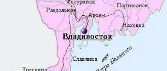
The third feature is the unique geographical location, which has not only disadvantages, but also its advantages. Despite the fact that there are 9,177 km from Vladivostok to Moscow, only 205 km separates Vladivostok from the border with China. This is very convenient for both tourism and business. It’s also a stone’s throw from here to Japan, and the countries of Southeast Asia are not that far away, where getting from Primorye is much faster than from the Russian capital. By the way, even if you don’t take into account the time gain, tours from Vladivostok to Thailand are 20-25% cheaper than from Moscow.
Geographical location . Primorsky Krai is located on the southeastern tip of Russia, in the southern part of the Far Eastern Federal District. From the south and east, its lands are washed by the Sea of Japan. In the north it borders with the Khabarovsk Territory, in the west with the People's Republic of China. The relief is mountainous, a significant part of the territory is occupied by the Sikhote-Alin ridge.
Pines and sea - a typical seaside landscape
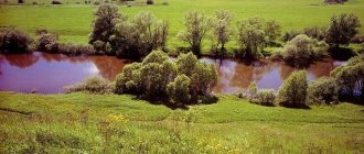
There are beautiful lakes, caves and waterfalls in the mountains. The largest lake is Khanka, on the border with China. The main river of Primorye is the Ussuri.
The unique nature of the Primorsky Territory with rare flora and fauna requires protection from poachers and other vandals. Now in Primorye there are 6 nature reserves, 3 national parks and one nature park. Here they are trying to preserve such endangered species as the Amur tiger and the Far Eastern leopard.
The Amur tiger is the master of the taiga
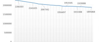
Population. Even during the times of the Russian Empire, Primorye was settled voluntarily and forcibly. Cossacks were sent here to protect our borders, peasants instead of serving, convicts to serve their sentences. Also, free land was allocated to all willing settlers. Under the Union, the Primorsky Territory began to be populated even faster. Up until 1989, there was a steady increase in both urban and rural populations. And then Primorye began to have serious economic problems, and the population began to decrease at the same rate as it had previously grown. Currently, 1,947,263 people live in the Primorsky Territory, which approximately corresponds to the level of 1980.
Emerald Valley - a man-made landscape paradise near Ussuriysk
The majority of Russians live in the Primorsky Territory (85.66%). In second place are Ukrainians (2.55%), in third are Koreans (0.96%). In fact, much more Ukrainians live here, and they began to come here en masse at the end of the 19th century, when regular sea communications were established between Odessa and Vladivostok. And now there are different realities: in Primorye there are many visitors from Central Asia and the Caucasus who, it seems, have no intention of returning home. More recently, another headache has been added: illegal immigrants from China, Vietnam and other Asian countries are entering Vladivostok by all possible means.
Crime . 11th place in the criminal ranking of regions is a very sad indicator, indicating that the crime level in Primorye is quite high. Despite the fact that Primorye is located in the south of the country, the population here is no less harsh than in the Russian North. Wild forests, the Ussuri taiga, remoteness from Moscow - all this leaves an imprint on local morals. An important factor in the high crime rate is the difficult economic situation in Primorye. In addition, Vladivostok also has its own specifics - a seaport, cargo transshipment, customs - fertile ground for the development of organized crime.
The unemployment rate in Primorye is very high at 6.87%. But local residents have a way to escape. For example, a common business for locals is driving cheap used Japanese cars to the western regions of Russia, where they charge completely different prices for them. The state is looking for different ways to increase business activity in the region, but so far the situation is far from ideal.
If we talk about official income, the average salary in Primorye is 27,365 rubles. The highest salaries are in the production of petroleum products (51.6 thousand rubles), in the financial sector (50.6 thousand rubles), in science (38 thousand rubles) and transport (35 thousand rubles).
Property value. The average cost of a one-room apartment on the secondary market is from 1.7 million rubles. New one-room apartments are sold for 2.5 million rubles and more. The price for two-room apartments is already much higher, and starts somewhere from 2.5 million rubles for old housing stock and 3.5 million rubles for new buildings.
Climate. The Primorsky Territory has its own Far Eastern weather, and it is unlikely to seem familiar to a resident of the European plains. This climate is classified as moderate monsoon. In summer, there are typhoons coming from the south, bringing fog, heavy rain and floods. Of course, farming in such conditions is hellish work. In the hottest summer months, the average temperature is +17…+26°C. In winter, the opposite is true. Cold northern winds bring dry frosty air. Although the average temperature in January is −15°C, the sea subjectively feels even colder. And in the depths of the continent, even the thermometer will clearly show −20° and below. As already mentioned, the region is very rainy and the average annual precipitation is 600-900 mm per year. True, most of them fall in the warm season.