The island has a beautiful name “Olkhon”, meaning “dry”. And indeed, if you move just a couple of kilometers from the coast, you will find yourself in a real desert. But the island is famous not only for its contrasts. You will visit pristine beaches, mountain ranges and even relax in the winter hut. This type of vacation will appeal to anyone, even the most experienced tourist.
The island is located almost in the center of Lake Baikal at a depth of 1642 meters. This is a unique place, its outline reminiscent of a lake. The climate of Olkhon differs from the surrounding natural conditions. In summer it is much warmer here, and winter is bitterly cold. Rain and strong winds are frequent on the island, from which local fishermen suffer. Olkhon is recognized as the historical, cultural and geographical center of the entire lake. It is shrouded in numerous beliefs and traditions, and more than 143 archaeological finds have been found on its territory.
There are a total of 26 islands on Baikal, among which Olkhon is the largest island inhabited by people. Its area is 730 sq. km. The name "Olkhon" comes from the Buryat "oy-khon" and means "woods". The forest zone is found only in the center of the island, and the rest of the territory is occupied by the steppe. No more than 1,500 people live here in the village of Khuzhir - in the most densely populated place on Olkhon Island.
This place will appeal to nature lovers, as the island has unique and amazingly beautiful landscapes. The weather here is good almost all year round, ideal for walking. You can travel on the island by car, boat, horseback riding, bicycles, and of course on foot. From early May to December you can get to Olkhon by ferry, and in winter you can get there by car.
Cape Khoboy
This is the northernmost cape of Olkhon. Tourists come here in winter to approach the rock on the ice. Winter allows you to enter grottoes with huge icicles and splashes of ice. The entrances to the grottoes are on the northern side of the cape.
The caves are dark, so you need to have flashlights when entering them. There are grottoes in the rocks more than 20 m long.
“Khoboy” means “fang” in Buryat. The cape got its name from the similarity of a large columnar rock with a pointed tooth. If you look at the cape from Baikal, you can see a figure reminiscent of a woman’s bust, which is why the cape also has a second name – “Virgin”.
A Buryat legend tells that one young Buryat woman, who was jealous of her husband, was petrified and turned into a rock. And the deities (tengris) to whom she prayed told her: “As long as there is anger and envy on earth, you will remain a stone.”
Local residents considered the cape a sacred place and performed their religious ceremonies on it. Currently, various spiritual practices are practiced here. The cape is popular among representatives of different movements - religious and esoteric.
Only off-road vehicles can drive to Cape Khoboy, as there are shifting sands and steep climbs along the road. It is recommended to hire local drivers - here they not only transport tourists to the cape, but also act as tour guides.
Endemic territory
There are 2,600 species of animals in Baikal, and half of them can only be found here. For example, in the lake there lives a tiny crustacean, epishura, which acts as a kind of water vacuum cleaner. It passes water through itself, filtering and purifying it. Among the local rarities, it is worth noting the golomyanka fish. Firstly, it is viviparous, and secondly, due to the large volume of fat, it has a transparent body.
Baikal seal
Whitefish, omul, grayling and Baikal sturgeon are also found here. In total, there are 27 species of fish that are classified as endemic, that is, they are present only in this region. The Baikal seal is considered a local landmark. Surprisingly, during the lean season, when there is not enough food, she can delay her pregnancy! And when there is enough food, she can become pregnant again. Freshwater sponges that grow at great depths are also exotic.
Olkhon has a wide variety of landscapes. The steppes give way to pine groves; trees give way to sand dunes; the sands recede before the rocks. There are lakes and swamps. But what is most striking is the unusual properties of Baikal water. One moment it was dark blue, then turquoise, and a second later it became pearlescent, like the inner surface of a shell! The water is so pure that you can drink it straight from the lake.
Cape Burkhan and Shamanka Rock
This place is the most popular not only on Olkhon, but throughout Lake Baikal. Since ancient times, Cape Burkhan has been considered a holy place among the inhabitants of the island, and today it is also a natural-historical monument. To be filled with life-giving energy, people from all over the world come to the Shamanka rock.
From Irkutsk to the cape 285 km. You can get here by car - through the villages of Bayandai, Elantsy and Sakhyurta, and then take a ferry to the island.
Cape Burkhan is located near the village of Khuzhir - this is the western coast of Olkhon. From the cape to Khuzhir it is only 600 m. This is the largest settlement on the island - 1,300 people live here. There are hotels for visitors in Khuzhir.
Shamanka Rock is part of the Pribaikalsky National Park. This is a limestone-marble rock, which is easily recognized by its forked top. There is a cave 4 m high running through the rock – this is where shamans once performed their rituals. The cave is revered as a shrine among the Khorin and Barguzin Buryats.
Interesting facts about Shamanka:
- Ancient Tibetan graffiti has been preserved on the walls of the cave.
- At a distance of 150 m from the cave, on a marble rock, tambourines are painted. Scientists date these images to the Neolithic era.
- Shamans claim that tourists disturb the peace of the gods - they litter, write on rocks, make noise.
- The gods, the shamans say, began to take revenge on people. Since 2000, on the road leading from Khuzhir to the cliff, people and livestock are constantly dying, cars are falling down. UFO scientists believe that Cape Burkhan is an anomalous zone.
HIGHWAYS OF OLKHON
The roads on Olkhon are unpaved. You may be lucky and the main roads to the villages will be graded. Or maybe you won’t be lucky and you will fully feel the road surface a la “washboard” with your fifth point. But the most unpleasant thing that can await you on these roads are large stones sticking out here and there, which can be caught if the ground clearance of your car is low... The consequences can be quite unpleasant and result in many hours of “tanning” on the road and (or) calling a tow truck .
Roads of Olkhon
In addition to dirt roads, there are also sandy roads. For simple passenger cars, THEY are not my God!!! Well, the saying: “the cooler the jeep, the further you go behind the tractor” is also relevant here.
The kings of the local roads are the big-eyed UAZs of the “loaf” type. This is the most popular transport on Olkhon. This is probably the highest concentration of UAZ cars per square kilometer in Russia.
UAZ on Olkhon
The favorite color in which loaves are painted at the Ulyanovsk Automobile Plant is gray - simple and unpretentious. It is very unusual to see such a concentration of a huge number of identical cars of the same color. Maybe something with vision???
Lake Hankhoy
Lake Khankhoy or Elginskoye is located on the western coast of Olkhon. This reservoir has warm water and a lot of fish - fishermen from all over Siberia come here to fish.
Between Baikal and Khankhoi there is a powerful rocky ridge, climbing which you can admire the picturesque views of the Small Sea, islands, and the Primorsky Range.
Maloe More is a part of Lake Baikal, separated by Olkhon Island. The water area is part of the Pribaikalsky National Park.
Facts about Hanhui Lake:
- lake dimensions – 800 x 500 m;
- Lake Khankhoy is connected to Lake Baikal by a narrow channel - its width is only 2 m and its depth is 30 cm;
- lake depth – 4 m.
There is silt and algae at the bottom of the lake, but the water is still clear. There are 20-30 cm between the algae and the water surface. There are no trees along the shores of the lake, and its western part is swampy.
The lake contains:
- pike;
- stellate sturgeon;
- sorog;
- perch.
There are especially many pikes in the lake. There are specimens reaching 10 kg.
Near the lake you can see:
- archaeological sites;
- ancient burials;
- remains of religious buildings.
Not far from the lake, archaeologists found an ancient ritual complex dating back to the 7th century BC. It consists of over two dozen stone structures.
There are especially many tourists on the lake in July and August. It gets noisy here and people catch fish with nets. Therefore, it is better to come here later - in September, or vice versa earlier - at the end of June, when there are few tourists and fishermen here.
Baikal secrets
Many mysterious stories and legends are associated with Baikal and Olkhon. For example, near the ferry crossing there is a landmark that locals call “Sinner Mountain.” According to legend, in order to atone for sins, a person must climb to the top, holding a stone in his outstretched arms. From a distance, the slope resembles a dragon's tail - there are so many stones there, stacked in pointed pyramids.
Nerpa is the most popular souvenir
Another legend claims that Baikal is connected by an underground river to the Arctic Ocean! Otherwise, where did the seal come from in the lake? They say that in the center of the lake there is a place with a circular current that regularly “sucks in” fishing nets. It looks like a bathroom drain. It is believed that this is where the journey to the north begins. They also say that in ancient times there was a bridge on Lake Baikal along which it was possible to cross the lake on dry land.
Baikal has also presented many mysteries to scientists. For example, the Cormorant Island stone somehow moved tens of kilometers from its original position. Yes, the shores of the lake diverge by two centimeters every year, but this is clearly not enough to “move” the island over such a distance. An interesting fact is that about three hundred rivers and rivulets flow into Baikal, but only one flows out - the Angara. And the transparency of the water in Lake Baikal reaches 40 meters! By this indicator, it surpasses all other lakes in the world. There are many mysteries, so Baikal awaits researchers.
Cape Khorin-Irgi
In Buryat, Khorin-Irgi means “mare’s head.” The cape, which gave its name to the entire peninsula, is located in the western part of Olkhon, and if you look at it from the side, you can see the head of a horse floating in the water. On one side the cape is washed by the Maloe More, on the other by the Olkhon Gate Strait.
Cape Khorin-Irgi is separated from the peninsula of the same name by a chasm. Its width is 4 m, and the height of the walls is 10 m. In calm weather, you can go through the crevice in kayaks.
The peninsula is narrow and long. The slopes are rocky and steep. There are several rocky capes, bays and one lake. Many archaeological finds have been found on the peninsula. People appeared in this place about 5 thousand years ago - this is evidenced by numerous artifacts found by archaeologists.
There are several more capes and bays on the Khorin-Irgi Peninsula:
- Cape Halte. Located on the northern coast of the Kobylya Golova Peninsula. Religious buildings from the 17th to 19th centuries were discovered in the rocks. They are stone wells 1.3x1.1 m.
- Cape Tutyrkhey. The eastern cape of the northern coast of Mare's Head. Artifacts dating from the 5th to 10th centuries have been found here.
Lake Nuku-Nur is separated from Lake Baikal by rocks. In fact, this reservoir is located in a rocky funnel. The water in the lake is very warm in summer, but no one swims here - because of the living creatures that infest its bottom.
Since 1981, the Khorin-Irgi Peninsula has been classified as a natural monument of national importance. On the peninsula there is a yurt camp for tourists - “Kochevye”.
How to get there
The easiest way to get to Olkhon is from Irkutsk. By car you should drive along the northwestern coast to the village of Bayandai, then turn right and move to the MRS (village of Sakhyurta). From here, through the Olkhon Gate Strait, the ferry transports cars and passengers free of charge. You should be prepared to stand in line. Ferries run every 15 minutes. The distance from the pier to Khuzhir is 36 kilometers. It's half an hour away by car.
Ferry to Olkhon
Minibuses run from Irkutsk to Olkhon. A ticket costs from 500 to 800 rubles. The advantage of this option is that minibuses are transported by ferry without queuing. In summer, ships go to the island. They are moored in Zagli Bay near the ferry crossing. You can get to Khuzhir from the pier by taxi. The motor ship option is not cheap, but there is an opportunity to see Baikal in all its glory.
Cape Khorogoy and Kurykan Wall
Thousands of tourists come to Khorogoy every summer. The cape is located on the northwestern coast of the island - in its middle part. In 1879, the ruins of an ancient wall were discovered here.
Kurykans are a people who lived on Lake Baikal in the 5th-6th centuries. Then all the people disappeared. How and where is unknown. No one even knows what the Kurykans looked like. Scientists suggest that they could have gone north, and the Yakuts are their descendants.
Dimensions of the Kurykan wall:
- wall length – 180 m;
- height – 1.5 m;
- The thickness of the masonry in some places is up to 1.5-2 m.
A one and a half meter wall could hardly have been a reliable defense; most likely, it was much higher, but collapsed over time. The exact purpose of the wall is not known. Perhaps she protected local residents from raids, but this theory has many opponents. Most likely, the wall served as a kind of altar, and the cape itself was considered sacred.
Behind the wall, boulders were discovered in which ancient craftsmen had hollowed out bowls for sacrifices.
At Cape Khorgoy, visitors set up tent camps and swim in well-heated water. Due to the shallow depth, the water here warms up to +22 °C.
Now in the heat, now in the cold
Olkhon is a very bright place. The number of cloudy days a year on the island does not exceed fifty. There is so little precipitation that it can be compared with the regions of Central Asia. Winters here are quite mild and summers are cool. Spring comes late, and autumn drags on for a long time. In mid-summer, temperatures can range from 10 to 22 degrees, and in winter - from minus 11 to 26 degrees. Winds often blow that literally blow away the soil from the island, leaving sand behind. There are many winds here and each has its own name - kultuk, barguzin, sarma, verkhovik and others.
Olkhon is beautiful at any time of the year
These regions are characterized by sharp temperature changes. If somewhere in a mountain valley the thermometer shows 35 degrees of heat with complete calm, then late autumn reigns on the shore - the icy wind literally pierces right through. This is the insidiousness of Baikal weather. Therefore, even on a warm day, it is worth bringing warm clothes if you are going ashore. Otherwise, you will have to warm yourself by the fire.
Don't dream of swimming in the lake for a long time. Even in the midst of a hot summer, its temperature does not exceed eight degrees and touching it resembles a burn. My legs cramp immediately, as soon as I go into the water up to my ankles. And this is in the summer! You can swim on Olkhon only after July 19th. This is possible due to the fact that at this time in the shallow Small Sea the water warms up to 15-17 degrees. However, it still seems icy. But once you take a dip, you feel reborn.
Saraisky Bay
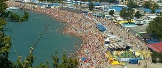
The most visited place on Olkhon is Saraisky Bay with the beach of the same name. The length of the sandy beach is 3 km. It is located near the village of Khuzhir. The water here is the warmest on Baikal - it is suitable even for children. Near the water there are small pebbles, but if you go 1 m into the water, there is a sandy bottom that smoothly goes into the depths.
Sarai beach stretches from the village of Kharantsy to Cape Burkhan. The beach is located between sandy hills. There are few trees here, but there are places to rest. There is minimal precipitation here, and summer temperatures can reach +50 °C. Strong winds often blow from Lake Baikal.
There are many beautiful natural places around the beach:
- The beach offers views of the majestic triangular-shaped mountains.
- In the depths of Olkhon there is a large pine forest where you can hide from the sun.
You can pitch tents on the beach. But cars may not be allowed to enter the beach. There is no infrastructure on the beach - people come here to take a break from civilization.
In the 30s and 40s, local forests suffered greatly from deforestation. The remains of the forest are gradually ending up in private hands.
Khuzhir village
After the crossing, everyone usually goes to the main village, which is called Khuzhir. This is the center of the island, both geographically and in all other respects. many housing options in and near Khuzhir from camp sites to private houses and rooms. There you will also find shops and cafes, and you can buy excursions. It is near Khuzhir that there is a stunning sandy beach and the famous Shaman Rock (more on them below).
The village is small - with a population of about 1,500 people. Most locals are employed in the tourism sector, and the tourist flow is only growing every year. Despite this, it is worth taking care of housing in advance because... prices are steep. The cost of living is an order of magnitude higher than on the Small Sea on the mainland. Prices for a comfortable room start from 2500 per night. You can find cheaper accommodation in other places, but a vacation on Olkhon in the summer is simply unthinkable without visiting Khuzhir. All other smaller villages, I list from the crossing:
- Yalga – 23 km
- Maly Khuzhir – 33 km
- Khuzhir – 37 km
- Kharantsy – 43 km
- Khalgai – 51 km
- Peschanaya – 57 km
- Uzury – 80 km
The most interesting are Kharantsy, Peschanaya and Uzury; I’ll tell you more about them below.
Cape Sagan-Khushun
Cape Sagan-Khushun (White Cape) is located in the north-west of Olkhon. On the cape there are steep, sheer white cliffs. Orange-red lichen stands out clearly on the white marble walls. The rocks are especially beautiful in the rays of the setting sun.
“Three Brothers” is the second name of the cape. There are three rocks here, which are lined up one after another. The name of the cape was given by a romantic legend about a girl and her three brothers, who were turned by their father first into eagles and then into rocks.
Sagan-Khushun is located 35 km from Khuzhir. The length of the rock mass is 600 m. All excursion routes to the north of the island pass along the cape. Olkhon. Getting to the cape on your own is not easy - only high-capacity vehicles will pass here. It is best to hire a driver-guide with your own car.
Interesting Facts:
- At Cape Three Brothers, the remains of a ditch and rampart, built in the 5th-10th centuries BC, have been preserved.
- There are many caves in the rocks of the cape. The largest one is in the Middle Brother rock. Its dimensions are 8x4 m. The height of the vault is 3 m. You can swim into this cave by boat.
- The cape has been given the status of a natural monument of regional significance.
Lichens growing on the rocks of the cape are a kind of indicator of air purity. They are very sensitive to pollution. The abundant growth of lichens indicates the pristine purity of Baikal air.
Weather
The climate on Olkhon is unstable and varies from season to season. To make your vacation a success, choose a period that is favorable for it.
Features of the climate on the island. Olkhon:
- average annual day/night temperature - +3.8/-2.9°C;
- summer temperature - +16.5...+18°C;
- maximum winter temperature day/night - -11.4/-17.2°C;
- the rainiest months are May, August and September, the driest are January, February and April;
- the sunniest days are June, August, July, the least sun is in January, February, December;
- the windiest months are November, January and December, the calmest are June, July, August.
In summer there is little rain and cloudy days on Olkhon. In the summer months there are approximately 23-24 sunny days, in the winter - 4.
Ogoy Island
The name of the island Ogoy translated from the Buryat language means “without water”. This is the largest island in the Small Sea and it is very popular among tourists. From the island to the shore of Olkhon - 1 km. The length of Ogoy Island is 3 km, its greatest width is 680 m. There is no water on the island.
The island is located opposite Cape Khorgoy. Herring gulls nest on Ogoy; there are countless of them here. Ogoy is on the list of protected areas. Relict vegetation grows here and rare animals are found. It is deserted, spacious, and in the distance you can see pristine forests.
Recently, Ogoy has become very popular among tourists. The reason for this is the Buddhist Stupa of Enlightenment. It was built in 2005.
You can get to Ogoy by boat in the summer, and by car in the winter, right on the ice. Ogoy Island, like Olkhon, is a center of shamanism. Scientists believe that this culture came to Baikal from the Buddhist world. In Siberia, shamans are very significant and widespread.
Enlightenment Stupa Facts:
- There is a path leading to the Stupa - it is believed that this is the path to oneself, to one’s inner harmony.
- On both sides of the path there are pyramids of stone. They are stacked by tourists making wishes. It is believed that when the wind destroys the pyramid, the wish will come true.
The highest point on Ogoy is 500 m. From the top there are beautiful views of the Maloye More and Oltrek (Crocodile) island.
What to see on Olkhon
First, about the most interesting places on Olkhon Island on Lake Baikal, which visitors try to explore in one day.
Khuzhir village
- Coordinates on the map: 53.193450, 107.343646.
Officially, there are 9 settlements on Olkhon Island, but most of them are endangered, with only a few officially registered residents. The largest settlement and unofficial capital of the island is called Khuzhir. The village dates back to 1938, when a fish canning factory was opened here.
Now the plant is no longer functioning, and the village lives almost exclusively on tourism. The main infrastructure of the island is concentrated in Khuzhir and its surroundings. Tourist centers and hotels have been built here, and there are several cultural institutions, in particular a museum and a library. There are very attractive and picturesque places around the village.
Pribaikalsky National Park
- GPS coordinates: 53.144259, 107.337761.
Pribaikalsky national punk is a natural heritage site included in the UNESCO list. It includes a huge territory. The entire Olkhon Island is considered part of it. The park was established in 1986 with the aim of preserving the biogeocenosis of Lake Baikal.
The total number of natural monuments included in the park is 54. Some of them are located on Olkhon: relict spruce forest or landscape natural monuments - capes Sagan-Shukhun and Khoboy. Only on the island is there such a species of mammal as the Olkhon vole.
Cape Burkhan and Mount Shamanka
- Coordinates: 53.203824, 107.338939.
Olkhon is one of the islands of magical attraction, a sacred place of Buryat shamanism. The most famous natural object was the rock at Cape Burkhan. She is called the Shaman. There is a grotto and a through cave. According to legend, it was here that the owner of the island named Ezhin lived, and people had no right to approach his home.
There are several entrances to the cave, the most convenient is located on the western side. At the foot of the mountain you can see an inscription in Sanskrit. This rock is one of the symbols of the island; it is most often depicted on numerous postcards with views of Olkhon.
Kurykan wall at Cape Khorgoy
- Coordinates: 53.105278, 106.971944.
There are many capes on Olkhon. One of them is called Khorga and is known thanks to the preserved remains of an ancient structure - the Kurykan Wall. It got its name from the Kurykan people who built it. Ethnologists believe that the Turkic Kurykan people are the direct ancestors of modern Buryats and Yakuts.
What was this wall for? Science cannot give an exact answer to the question. There are main versions. The first says that it was a kind of Kremlin - a defensive structure. The second goes back to the religious culture of the Kurykans. According to it, there was a sacred place here - an altar. The name of Cape Khorgoy itself is translated as “hidden”, “protected”, which corresponds to both assumptions about the purpose of the wall.
The cape is a convenient place for swimming: it is located near the Small Sea and is separated from it by a pebble spit.
Buddhist stupa of enlightenment on Ogoy Island
- Coordinates: 53.128973, 106.997899.
Off the coast of Olkhon, in the Strait of the Small Sea, there is the island of Ogoy. Here is a modern monument that refers to the spiritual culture of the ancient inhabitants of these places. The Buddhist building was erected in 2005. It is a snow-white three-stage concrete structure with a dome and spire.
The stupa of enlightenment is one of the symbols of Buddhism, the material embodiment of Buddha. Inside the structure there are voids where Buddhist relics are placed: manuscripts, mantras, shells from the sacred seas. There is also a figurine of a dakini, which is the name in Buddhism for the spirits of women - bearers of secret teachings. Relics were brought from Nepal itself.
Lake Shara-Nur
Shara-Nur is a small mountain lake that is no less popular among tourists than Baikal itself. The name of the reservoir is translated from the Buryat language as “yellow lake”. And it is connected with the abundance of yellow flowers - buttercups.
The lake is located at an altitude of 150 m above sea level. The reservoir is surrounded on all sides by forests and hills, so a simple tourist cannot find it without the help of guides.
Interesting facts about Lake Shara-Nur:
- Many people come here for the healing mud, which helps treat joints and skin diseases.
- After swimming in the lake, the skin becomes red - this is due to mineral salts.
- The water in the reservoir smells of hydrogen sulfide - it is part of the water.
- Mixed forest and reeds grow around the lake.
- Here you can see the Scorch, an endangered species of duck. Today, the number of fires is only a few.
- The water in the lake is warm, rich in minerals - it is pleasant and healthy to swim in it. In particular, swimming in the Yellow Lake is recommended for arthritis and for general strengthening of the body.
- Shara-Nur is located 6 km from the village of Yalga.
- Red deer come to the lake for natural salt.
- There are no fish in the lake. The bottom is covered with silt and algae.
The average summer temperature is +16 °C. The weather here is mostly sunny. The water temperature in summer reaches +23 °C. In winter there is little snow and cold. The best time to come to the lake is from May to September.
Tall grasses grow near the lake - thyme, alpine asters, lilies. And near the forest there are rose hips and Kuril tea. Poplars, birches, pine and larch trees grow in the forest.
Entertainment and recreation for Olkhon tourists
Finding yourself alone with the beautiful nature of Olkhon Island, you can not only contemplate and admire the views, but also actively relax. Popular activities here include fishing and hunting. The island has many suitable places for beach lovers.
Small Sea
- Coordinates: 53.269618, 107.314262.
One of the straits washing the shores of Olkhon and separated by an island from the endless waters of Baikal is called the Small Sea. This is an ideal place for a beach holiday, as the bays of the strait warm up well in summer. It’s sunny here and the water is warm – what else do lovers of sunbathing and swimming need? They say that a Malomorsky tan lasts much longer than a southern tan.
Zagli Bay and Lake Nurskoye
- Coordinates: 53.035908, 106.938245.
The warmest place in the Irkutsk region. There are much more sunny days here than in the region as a whole, and much less precipitation. The shores of the bay are completely bare, without any vegetation. A narrow channel connects the waters with a small lake called Nur, or Nurskoe. This is what attracts tourists the most. In summer, the water temperature here heats up to +25 degrees. It's hard to resist the temptation to swim in it.
The sandy beach of Saraisky Bay and the village of Kharantsy
- Coordinates: 53.221058, 107.418458.
Sand dunes and cozy meadows surrounded by pine forests - this is the shore of Saraisky Bay, which traditionally attracts tourists. The local beach is three kilometers long and stretches between Cape Burkhan and the village of Kharantsy.
Thanks to the cape, the modest village, with less than 100 registered residents, has become a favorite vacation spot. Tourists set up campsites here. Those who do not want to spend the night in a tent can pay attention to the airfield for small aircraft. It has a guest room.
Lake Shara-Nur
- Coordinates: 53.104627, 107.255018.
The waters of this lake are considered healing due to the content of hydrogen sulfide, and healing mud has also been found in it. Interestingly, Shara-Nur is the only mountain reservoir on Olkhon. The name translates as “Yellow Lake”.
So named because it is located among meadows where yellow buttercup flowers grow. The depth of the reservoir is shallow, so its waters warm up well, making the place attractive for relaxation. Many people come here to improve their health. Shara Nur attracts people with joint diseases, for the treatment of which the local mud is very useful. Salty lake waters will also help people with diseases of the nervous system improve their health.
Local residents “scare” tourists with tales that a yellow snake lives at the bottom of the lake and gas bubbles appearing on the surface of the lake are “products” of its breath. But scientists know: these bubbles are hydrogen sulfide, which makes the water healing.
Lake Hankhoy
- Coordinates: 53.152688, 107.169391.
Lake Khankhoy is a joy for fisherman; it is famous for its abundance of fish. Here you can catch perch, sorog, and the most desired trophy is pike. It bites well on a spinner, so the reservoir traditionally attracts spinners. The most popular method of fishing here is float fishing, that is, with a regular fishing rod.
Those wishing to go fishing should go to the lake in the northern part of the island. A powerful rocky ridge descends to its shores, separating the reservoir from Lake Baikal.
Not far from the lake there is a tourist base of the same name, where tourists can stay in a Russian Siberian traditional hut or a national Buryat yurt. Nearby you can also see the ruins of ritual complexes from different centuries, traces of religious buildings, which gives the local fishing a special “magical” flavor.
Hunting winter hut
- Coordinates: 53.098508, 107.283239.
A few kilometers from Lake Nur there is a place for lovers of another ancient craft - hunting, which has become a popular hobby these days. A small house located on the way to the east coast of the island is ready to welcome hunters. There is always firewood, matches, salt, and sometimes some long-lasting provisions.
According to the unwritten laws of tourism, having taken advantage of everything necessary, you need to leave supplies for the next travelers, i.e. prepare firewood, share food supplies, you can leave warm clothes, etc. Then the winter hut will always be hospitable for hunters and travelers.
Baikal View Hotel
- Address: Khuzhir village, Rossiyskaya street, 17.
The main type of accommodation on the island is camping and tourist centers, but there is also a place for those who like a comfortable stay. The Baikal View Hotel offers its services on the shore of the island, near the village of Khuzhir.
There are terraces overlooking Lake Baikal, an outdoor swimming pool, an observation deck, and a sauna. There are sports and children's playgrounds on site. The hotel will offer you various options for leisure activities and excursions around the island.
Mount Zhima
This is the highest mountain on Olkhon island. Its height reaches 1276 m above sea level. Its location is the eastern part of the island, Cape Izhimei. From Buryat the name of the mountain is translated as “master”.
On one slope of the mountain, on the western side, a relict spruce forest grows. It grows so densely that it does not give any other tree species a chance to germinate. On an area of 340 hectares there grows flora that almost became extinct during the glaciation.
It will take a whole day to climb the mountain, so you need to take a supply of water and food with you.
Local residents consider the mountain sacred. Legends say that the gods lived here. Once upon a time, on the top of the mountain there was a small log hut and a hut - they were placed here by Olkhon shamans. An ancient elder allegedly lived here, helping lost travelers find their way.
The depth of the canyons reaches 90-100 m, and their width is from 2 to 20 m. People who lived in this area believed that opposite Izhimei, right where the deepest depth is, they enter the kingdom of the dead.
To the northeast of the shore - 10 km, the greatest depth of Lake Baikal is recorded.
Travel around Olkhon
There are no predatory animals at all on Olkhon Island. Surprisingly, there are not even small insects here. The temperature remains high throughout the summer, which greatly attracts vacationers. Before you go on a trip around the island, do not forget to take a primus stove, as there is simply no firewood left on the shore. Also, be sure to take plenty of water and fuel, because the nearest gas station is more than 250 km away, and sometimes the distance goes beyond 300 km. Small mountains and hills will not allow you to get closer to the water. You'll have to work a little to replenish your supplies. In the north of the island it is pleasant to cycle and walk. There are amazing sunsets and sunrises here that will not leave anyone indifferent.
Olkhon Island belongs to the territory of the Pribaikalsky National Natural Park. The best time to visit it is in the summer from June to September. The lake is a fascinating sight even when frozen. You can wander around it from January to the end of May. It is during these months that the ice thickness reaches 1.5 meters.
Island
Olkhon is the most picturesque and interesting place on Lake Baikal. The center of Buryat and Asian shamanism is located here. One of the legends says that the first shaman received his gift on this island. They also say that Genghis Khan is buried on the island. Let's take a look at some local attractions.
Nyurgan Bay
Nyurgan Bay is famous for its unique sand dunes stretching along the coast. The length of the beach is 6.5 km. It is located on the western coast of Olkhon, in its middle part.
In the north of Nyurgon (another name for the bay) there is Cape Sas, in the south - Cape Nyurgan. There are old buildings on the shore.
On Nyurgon, archaeologists found an ancient site of the Neolithic era (5-3 centuries BC).
Winds constantly blow on the bay - from the direction of the Small Sea. The wind carries sand from the coast upward, resulting in high hills. The area occupied by the dunes is 3 square meters. km. These are the largest sand deposits not only on Olkhon, but on the entire coast of Lake Baikal.
Nutrition
There are no usual supermarkets here, only small grocery stores. Please note that prices here are approximately twice as high as in Irkutsk. Many vacationers prefer not to waste time on cooking, so they eat in cafes or at camp sites, if meals are provided there.
There are several cuisines in use on Olkhon: Russian, Siberian and Buryat. Lunch per person costs about 400 rubles on average.
An example of lunch with prices in a cafe about. Olkhon:
- Solyanka - 150 rubles;
- Bukhler (Buryat meat soup) - 170 rubles;
- sagudai (cold fish appetizer) - 200 rubles;
- mashed potatoes - 90 rubles;
- meat cutlets, 1 pc. — 50 rub.;
- meat pies, 1 pc. — 50 rub.;
- fruit drink, 200 ml - 45 rubles;
- tea, 200 ml - 25 rub.
Cape Budun
The cape is located on the western coast of Olkhon Island. In Buryat, “Budun” means “fat.” The cape received this name for the large size of the rocks that rise vertically above Lake Baikal.
The highest peak of the cape is 100 m above sea level. To the north and south of the cape lie two bays - Ulan-Khushinsky and Bayan-Shungen.
Facts about Cape Budun:
- In a 10th-12th century burial ground, archaeologists discovered a birch bark quiver and a disk-shaped calendar. The bronze calendar depicts animals symbolizing the 12-year eastern cycle.
- Precious stones were found on the cape - sapphires and rubies.
- Burials dating from the 4th-3rd centuries BC were discovered in the southwest of the Cape. – ceramic vessels and a jade knife were found in them.
There is a lot of thyme growing on the sandy beach, and deciduous trees in the distance. The forest here is sparse; in the summer there is a camp for children's health.
If you climb the cliffs of Cape Budun, you can see the panorama of the Small Sea. It is 16 km from here to Cape Burkhan if you follow the coastline.
How to book a seat on the bus to Olkhon
It’s like on the social network VKontakte - “everything is complicated,” although in fact it’s quite simple. Now I'll tell you everything.
Private buses to Olkhon have several different owners, which means several different phone numbers by which you can book a seat .
Basic schedule of minibuses to Olkhon and back in high season
— from Irkutsk to Khuzhir at 9.30 or 10 am and at 13.00 or 13.30 minibuses depart
— from Khuzhir to Irkutsk flights go two (three) times a day at 10 o’clock, at 13.00, if they pick up passengers at 16:30
I know 3 places from which private minibuses depart for Olkhon, each of them is assigned a specific telephone number, prices and schedules are the same for all. By all phones (except 4) you can book seats at BOTH ends!
- At the bus station (directly opposite it across the road) next to the Master Grill cafe, tel. 8902516831 or 89025772020
- From the Central Market (photo studio “Original”) tel. 89021714961
- From the Central Market in the parking lot near the Shopping Complex tel.: 89021714961
- And another number where you can order a minibus, BUT ONLY from Khuzhir to Irkutsk 89025156591
In the summer and February-March, the number of shuttle bus trips increases, but the actual time and place of departure of a particular minibus with the operators by calling the numbers I gave. You never know if something will change.
You can also check the relevance of the information and book your seats on the Olkhon-Express website.
Schedule in February 2021
Boarding point for the Irkutsk-Khuzhir bus from the bus station (Master Grill cafe)
Tel. 89025772020
Minibuses to Baikal from the bus station (cafe "Master-Grill"
Bus Irkutsk-Khuzhir from the Central Market (near the Shopping Complex)
Tel.:89021714961
Minibuses to Baikal from the Central Market
Yes, that’s how it is, in the 21st century, booking a bus to Baikal is done by calling , which the operator records somewhere in his notebook and after that you can safely come to the collection point. You shouldn't be late, because... minibuses try to stick to the schedule.
Be sure to check if he wrote down your last name correctly and you understood the booked time and date. Somehow I came by appointment and wasn’t on the list, but the drivers quickly got their bearings and transferred us to another minibus, so we didn’t even have time to get scared. Fortunately, it was Monday.
Please note that these minibuses are not very convenient for travelers with bulky luggage. As our driver explained, this year in the spring some new order was issued by the traffic police, according to which the luggage rack on the roof of the bus must be additionally registered, and even in Moscow. I hope this issue will be resolved by this summer, otherwise it’s not very comfortable to travel on a bus filled to the brim with bags.
Since the path is not close, many may be interested in the issue of stopping for all sorts of natural needs.
On the Irkutsk-Khuzhir-Irkutsk route, approximately halfway through the journey, all minibuses stop at roadside cafes in the Bayandai village, where you can have a snack and do everything your body requires. In principle, everything there is pretty decent, and the staff is already quite cheerfully speaking English.
They really shouldn’t be bullied when such a wave of foreigners stops at their cafes, city restaurants can only envy.
In a minibus to #Khuzhir you feel as if you are in some other country. The only Russians here are us and the driver (Buryat). The rest of the passengers are completely international - Swedes, Poles, French and even Argentines! But 70% of tourists to #Baikal are Chinese, who have been storming the beauty of Baikal for the second year and who are now a pleasant surprise. If there are Chinese tourists everywhere in the world, this is a punishment, almost the same as our compatriots, whom you least want to meet somewhere, so as not to spoil your vacation. But I haven’t seen such typical Chinese here; it seems that Chinese hipsters go to Baikal more often. Young, 20-25 years old, with expensive cameras and iPhones, they speak good English, and they even speak English with local village dogs))) Polite Chinese people))) someday I’ll tell a story or even several about them. #chemezova_travel #huzhir #olkhon #baikal #baikal2017 #live_on_baikal #lifebaikale #travelblog
Posted by ⭐Elena Chemezova⭐ (@elenachemezova) Mar 16, 2021 at 3:27 PDT
Zagli Bay
The bay is located in the southern part of Olkhon. The bay cuts into the land for 3.5 km. On the northern coast of the bay there are many small bays where ships hide in strong winds. This is the sunniest place in the entire Irkutsk region.
Features of Zagli Bay:
- The bay enjoys sunshine for up to 2,400 hours a year – almost like in the Caucasus.
- There is little precipitation here - about the same as in Kazakhstan. The amount of precipitation per year is 160-170 mm.
- The bay is clearly visible from the road.
- There is no vegetation on the shore. There aren't even bushes.
It is unknown how the name of the bay, Zagli, is translated. Perhaps it meant "fishing places." In the ancient Buryat language there are the words “sal” and “zal”, which mean raw fish.
Tourists prefer to stay at Lake Nurskoye - it is located at the very end of Zagli. In the north, the lake is overgrown with reeds, reeds, and pondweed.
There are many interesting plants in the southwestern part of the cape. Here, botanists discovered more than three hundred relict plants - 11 species are listed in the Red Book.
Adviсe
- The exact date of the opening of the ice crossing is always written in the Irkutsk media. Google: “opening of the crossing to Olkhon”.
- February 23 and March 8 are days when the number of tourists on Olkhon increases sharply; On holidays, hotels are sometimes full. For these dates you need to make reservations as early as possible.
- Take a thermos and don’t be lazy to refill it with hot tea before every walk.
- Sunglasses and sun cream are useful in winter and summer. In clear weather, due to the reflection of sunlight from the snow, the eyes become very tired, and the skin quickly burns.
- A sweater and a light jacket will not hurt even in July-August - in the evenings it is often cool here, especially near the water.
- There are no dangerous predators on Olkhon, and snakes are introduced only on the eastern shore, where tourists are prohibited from entering. There are practically no mosquitoes and midges and no ticks at all.
Pad Tashkiney
Tashkinei is a valley or pad located in the eastern part of Olkhon. The valley, surrounded by mountain ranges, gently slopes down to the Great Sea.
The rocks in the valley have a variety of shapes, they are covered with lichen, and a stream flows along the bottom. At the bottom of the valley there are currants and willow trees.
Near the stream there is a hut in which the windows are covered with film. It can accommodate up to 8 people. This house is the remains of an ancient Buryat settlement.
There is a legend that a hermit lived in this house. There supposedly stood a mill near the stream, where those who turned to the elder for help could grind grain. From the water mill, only the remains of the wheel that moved the millstones have survived to this day.
Several interesting archaeological sites were found in the valley - altars and burial grounds. The exhibits found here can be seen in the local history museum located in the village of Khuzhir.
Fishermen love to come to the Tashkini Pad; here you can find:
- pike;
- sorog;
- grayling;
- perch.
A big advantage of honeydew is its accessibility to cars. In the eastern part of the island, Pad is the only place where you can easily reach by car.
The pad is protected from cold winds by rocks. There are almost no waves here, you can easily launch boats with motors - this makes fishing even more interesting and enjoyable.
Things to do?
Despite Olkhon’s remoteness from the mainland and the simplicity of local life, you won’t get bored here. Leisure on the island is not the same as in traditional resorts. There are no discos, nightclubs or entertainment centers here; time is spent here for the benefit of soul and body.
What to do on Olkhon:
- Beach holiday. In summer you can sunbathe beautifully on the sandy coast. The main beach on the island is Saraisky. It stretches for several kilometers from the village of Kharantsy to the Shamanka rock. The width of the sandy shore is about 1 km. Everywhere there are clearings surrounded by pine trees.
- Fishing. Almost every tourist center offers its guests boat trips. You will be taken to the most fishing places and at the best time for biting. You can fish here using spinning rods and fly fishing (with live bait). Omul and grayling are caught. One of the best places for fishing is the Tashkini Pad, stretching between the hills. Fishermen say that in a day you can easily catch up to a hundred heads of grayling with one fishing rod.
- Excursions. The excursion center and tourist centers offer vacationers different options for excursions - on foot, by car and by water. We especially recommend evening boat trips.
- Getting to know local traditions. Olkhon is not deserted; it has a rich history and traditions. Tourists can visit a shaman or an entire Buryat village in an organized manner. If desired, you can even order one or another ritual from the “clergyman.”
- Paragliding flight. This pastime is of interest to extreme sports enthusiasts. It’s especially cool to fly over Olkhon in the evening when the sun begins to set. Flight cost - from 1,500 rubles.
- Hiking in the mountains. The highest point on the island is Mount Zhima. Its height is 1,672 m, which is quite low for mountain peaks. Even an unprepared person can climb it. But there is no path to the top; you have to walk along “virgin lands”. The slopes of the mountain are densely overgrown with ancient spruce trees. They are so old that they are said to have been growing since the Ice Age. When climbing, you must have food and water with you, as the ascent lasts at least 4 hours.
Khadai Mountain
This pass is encountered by tourists on the road from the ferry crossing to the village of Khuzhir. Almost all guests of the island come to this settlement.
Having reached the pass, the travelers presented gifts to the spirits - in gratitude for the successful crossing. Today, tourists continue the traditions of the aborigines, leaving candies at the pass - local gophers eat them with pleasure.
Hunting winter hut
There is a functioning winter hut near Lake Shara-Nur, where any traveler can stop and spend the night. There are always all the essential items a traveler needs here. They are most often left behind by previous travelers. In gratitude, you can also leave something for future guests of the winter hut.
For tourists
The most ideal option to see all the sights of the island is to stay in Khuzhir. From here you can make excursions in absolutely any direction. Without going into details, you can explore the entire island in two weekends.
Uzury and Usyk
Uzury is a tract located in the northern part of Olkhon. Here is the Haga Yaman Bay - it is formed by rocks. The place is not only extremely picturesque, but also comfortable for living. It is quiet here, there are no piercing winds. Nearby is Mount Tolgoi, “Head” in Buryat. Its height is 666 m.
At a distance of 2.5 km from Uzur there is the Usyk village. Not far from the farmstead there is an old, non-working farm. People living in Usyk are practically cut off from civilization. There is no telephone connection or internet here.
Where to eat in Khuzhir
I don’t pretend to be completely comprehensive and objective in my assessments, but I want to highlight a few places where you can definitely eat in Khuzhir:
- Cafe "Kudesnitsa" . Really very tasty food!
- Poznaja . The name speaks for itself - here you can try the very dish of Buryat cuisine that is popular in these places - poses. True, the service and waiting time scares off many.
- Hedgehogs-Frosts . Coffee, ice cream, lemonades, smoothies, cocktails. As if not far from civilization
Museum of Local Lore named after. N. M. Revyakina
The museum was founded by local history enthusiast and school teacher Nikolai Mikhailovich Revyakin. The museum is located in the village of Khuzhir. The fee is symbolic, just a few rubles for entry.
The museum presents the following exhibitions:
- rocks;
- religious objects;
- Buryat household items;
- collection of plants - herbarium;
- zoological exhibits.
The museum was created in the 50s of the last century. Under the leadership of Revyakin:
- two dozen sites dating back to the Neolithic era were discovered;
- a relict spruce forest was found near Mount Zhim;
- ethnographic materials were collected.
Revyakin N.M. corresponded with academician V.A. Obruchev. and took part in scientific expeditions.
Today the museum houses over 5 thousand exhibits, which cover the time period from the Neolithic to the present day.
The museum contains documents relating to special settlers. During the times of repression, exiles from Belarus, Lithuania, and Western Ukraine arrived on the island.
The most interesting places of culture and religion on Olkhon
There are also several attractions of cultural significance on the island, which can also tell you a lot of interesting things about the past of this area.
Khuzhir Local History Museum named after. N.M. Revyakina
- Address: Pervomaiskaya st., 2, Khuzhir village.
The museum grew out of a small school local history club, organized in 1952, thanks to the enthusiastic local historian and director of the Khuzhir school Nikolai Mikhailovich Revyakin. Together with his students, Revyakin discovered more than 20 ancient human sites recognized as archaeological sites.
The exhibits collected during the expeditions laid the foundation for the school museum, which “grew” with more and more new finds. In 1983, the year of the teacher’s death, the school museum was renamed the Khuzhir Museum of Local Lore. N.M. Revyakina. Now it is a municipal institution. Its exhibition includes materials on archaeology, ethnography, history, mineralogy and the nature of the region.
Oshchepkov Art Gallery
- Coordinates: Pervomaiskaya street, 24.
A private gallery maintained by artists Vladimir Fedorovich Oshchepkov and his wife Arina Valentinovna Yatsyno. The gallery and workshop were built according to their own design. Paintings by artists are exhibited here and there is a souvenir shop where crafts of all kinds with views of Olkhon and Baikal are sold - wood products, birch bark, ceramics, felt, refrigerator magnets and various crafts.
Khuzhir village library
- Address: Baikalskaya street, 8, Khuzhir.
Anyone who is tired of contemplating the beautiful views of Olkhon can visit the Khuzhir Municipal Library, which contains not only world and domestic classics, but also local history literature about Olkhon Island. If you want to know more about Baikal, go here. In the library you can also get acquainted with the local press and get an insight into the concerns of the island population.
Church of the Icon of the Mother of God "Derzhavnaya"
- Address: Gorny lane, 1A, Khuzhir village.
The island cannot boast of an abundance of monuments of Christian culture. A small church on the top of a hill in the village of Khuzhir, with a beautiful view of the Small Sea Strait, was erected in honor of the “Sovereign” icon of the Mother of God through the efforts of Natalya Usova. After the death of her husband, the widow came to the priest with the idea of building a temple - and the idea materialized.
The history of the temple and parish began in 2000, and the church was built and consecrated in 2006. Painted white with blue trim, the Orthodox landmark makes a reverent impression. Despite its small size, it is visible already when approaching the village. Next to the temple is the house of “Philoxenia,” the ascetic missionary Sergei.
Buryat village
This village is preserved especially for tourists. Its official name is Malomorets, but on excursion routes it is presented simply as “Buryat Village”. Tourists can see with their own eyes how the Buryat people lived for centuries. In the village you can hear a story about the traditions of the Buryats and their way of life. The village is located 4 km from the village of Khuzhir.
What is interesting in the village for tourists:
- The village offers national cuisine. If you wish, you can drink a glass of tarasun - this is a milk alcoholic drink.
- You can see a yurt for 8 people, divided into male and female halves. At the entrance to the yurt, tourists are greeted by Buryats dressed in national costumes.
- Here you can listen to drawn-out songs performed by Buryats.
- Tourists will be shown how to dance Buryat round dances - yokhor.
Food
Olkhon is definitely not about gastronomic tourism. You shouldn't expect high cuisine, but you won't go hungry here either. Most of the cafes are located on the main street of the village - Baikalskaya. In winter, the number of operating establishments is greatly reduced compared to summer, since there are fewer independent tourists in the cold season. And for those who come as part of group tours, the tour price usually includes meals in hotels.
The Olkhon cafe (Baikalskaya St., 34a) is open all year round - breakfast will cost 150-300 rubles, a full lunch - 400-500 rubles. In a stylish coffee shop at the Port Olkhon art residence, a small portion of carbonara costs 600 rubles, coffee - from 200.
Pozy (or buuz) is a traditional Buryat and Mongolian meat dish, also popular in the Irkutsk region and Trans-Baikal Territory, similar to manti and khinkali.
The ideal option for Olkhon is to cook on your own. Take a couple of gas cylinders and a burner. Some camp sites have kitchen areas, but usually only a thermopot and a microwave are available (you can find out about the availability of a kitchen from the reviews on the booking). There are several grocery stores in Khuzhir, the prices in them are not much higher than in Irkutsk, the choice is small, but everything you need is there. The Gastronom store (Baikalskaya St., 38) bakes and sells fresh bread every day. There are no ATMs on the island, but you can pay by card in any store or cafe.
Seal rookery
Between capes Izhimei and Ukhan there are rookeries where a huge number of seals bask. Animals lie on stones that warm up well in the sun. There are many rookeries here, and each one contains hundreds of individuals. The seal “beach” stretches for several kilometers.
When people approach, seals immediately jump into the water, so it is almost impossible to photograph them at close range.
You can learn other interesting facts about Olkhon Island from the following video:
Olkhon Island is filled with natural beauty and unique historical and archaeological monuments. It will be of interest to lovers of nature, fishing, history, ethnography, and simply tourists who want to follow interesting routes.
Peschanaya village
How to get there: from Khuzhir through Kharantsy there is a 20-kilometer dirt road.
There is little natural beauty here, but omul is caught here. From the shore you can watch fishing boats leaving to fish and returning with a load of fish. Or you can go to a snack bar and eat the freshest omul in any form you like (there is smoked, fried, and fish soup).
Bays of the Small Sea on Lake Baikal, Darlatinsky Bay
Despite such beauty, we move on. Barguzin began to intensify, the wave became larger, we had to come closer to the shore, it was a little quieter there. An ancient Gerbil appeared ahead. It's hard to believe, but in the late 30s, a correctional colony was organized here, which was part of the Gulag system.
Ahead we saw a destroyed pier (only supports remained), because fish used to be unloaded here. Go ahead. There is a view of Cape Sasa ahead, and the wind is getting stronger and making our movement almost impossible. We had to land on one of the beaches near Cape Sasa. Surprisingly, there were vacationers here, despite the terrible roads in this area.
While the sea was stormy, we had to start preparing lunch and resting. By 16-00 the wind had died down a little, and we decided to move on, but after walking only 5 kilometers, we had to look for shelter in the bays again. By that time we had entered the waters of Darlatin Bay.
It was risky to go further, after 8 kilometers the Small Sea ended, and the waves of the Big Sea were many times larger, in addition, it was more difficult to find a place for a safe parking there. So the decision was made to moor and spend the night on the shores of Darlatin Bay.
I have already written that the bays of the Small Sea are very beautiful, each bay is beautiful in its own way. So Darlatinsky Bay looks very beautiful. The bay was filmed on video and photos, you can appreciate its beauty yourself. Beautiful rocks, forest, the energy of this place is just off the charts. I really liked it here.
One of the most beautiful bays of the Small Sea
Despite the remoteness, the place is equipped for relaxation. There is a table, a stove, a sauna and just a platform for setting up a tent
Small pebbles in the waters of the bay
Workers in the wild on Olkhon
We promptly unloaded the boat and organized drying of clothes (after all, we were well wet by the waves). As it turned out, the bay was favored by local fishermen. There was a table with benches, a bathhouse was built, and there was a winter hut in the forest. After setting up the tents, we decided to do a little fishing, because the places here are dark blue. Not far from the shore, seals periodically surfaced, which means there are fish here.
It began to get dark, we were completely alone here, when suddenly a motor boat began to approach the shore. It turned out that this place was chosen by a tourist from Italy named Fabrizio. In Khuzhir, he rented a boat and agreed to rent a winter hut. In the evening we sat together and talked in English over a bottle of good wine.
In the morning we got up early, Baikal was like a big mirror, not a single wave, it would be a sin not to walk on such a smooth surface. We quickly packed our things and loaded the boat. And here Fabrizio came to see us off. He arrived in Darlatinsky Bay for 5 days. There were only 8 kilometers left to the northern tip of Olkhon Island, or maybe less. The speed of the boat is 30 kilometers per hour and after 15 minutes we are already rounding Cape Sagan-Khushur. The spire of Cape Khoboy is visible ahead; at full speed, cutting through the Baikal surface, we are rushing towards it.
Northern part of the island, Three Brothers rocks