Nyagan is located on the Nyagan-Yugan River in the Khanty-Mansi Autonomous Okrug.
It was originally created as a village for people harvesting timber and was called Nyakh.
In 1985, it acquired the current name Nyagan and the status of a city on the map of Russia.
The name sounds in the Khanty language and means “small river flowing through flat terrain.”
Population – more than 60 thousand people.
There is an air terminal, industry, education and culture are developed.
Geographic information
Nyagan was built on the left bank of the Nyagan-Yugan River (the right tributary of the Ob River), in the central part of the West Siberian Plain. In the southeast, 230 km away, is the center of the Autonomous Okrug Khanty-Mansiysk. In its region of Ugra, the city is the largest in terms of area. With an area of 814 sq. km, only 4% of the urban area is built up. The remaining space is occupied by the Siberian taiga, small rivers and numerous lakes.
According to natural and climatic conditions, the region is classified as a region of the Far North, with a continental climate. Winter is long and cold, summer is short and warm. In the coldest month of January, the average temperature is minus 23.1 °C, in the warmest month of July - plus 17.3 °C. The average temperature for the year is minus 1.4 °C.
Nyagan on the map of Russia: geography, nature and climate
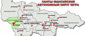
Located in the northern part of Western Siberia, in the Tyumen region.
The distance to Khanty-Mansiysk is 230 kilometers, to Tyumen - 565 kilometers.
Covers an area of more than 900 square kilometers. The satellite map of Nyagan shows that only 4% of them are the area of the city and industrial enterprises. The rest of the territory is a kingdom of forests, lakes and small rivers.
The city is surrounded by pristine nature and unique landscape.
It is exposed to a harsh continental climate. The city is equated to the territories of the Far North.
There are often sharp temperature changes and strong winds here.
Winter is frosty and long. It's warm in summer, but it ends quickly.
General information
The city is the administrative center of the urban district of the same name. It is located in the northwestern part of the Khanty-Mansiysk Autonomous Okrug, which is also called Yugra. The population of Nyagan in 2021 was about 58 thousand people.
The city-forming industry is oil and gas enterprises, including production and processing of hydrocarbons, service companies. In addition, there are large enterprises for wood processing and the production of highly purified quartz concentrate.
Nyagan has an intercity bus service and is connected by roads with neighboring regions to the south, including Yugorsk and Perm Khanty-Mansiysk, to the west with Tobolsk and Tyumen, and to the north with the village of Priobye. A train from Moscow to the Ob region passes through Nyagan by rail. Air service connects the city with Tyumen and Beloyarsk, in addition, the airport receives rotational aircraft.
Sights of the city of Nyagan
Museums
- Museum and cultural center . The local history museum is located here. Its exhibition includes more than 11 thousand items. Among them are the archaeological collection of the Ancient Emder complex; monuments reminiscent of the construction of Nyagan and other interesting exhibits.
Monuments
- Monument to the Janitor and the Plumber . You can see it in the first microdistrict. Erected in gratitude to utility workers for the cleanliness and tidiness of the city.
- Monument to a Girl with a Dove . Located on Golubinaya Square. That's what the residents themselves called it. This is one of the symbols of Nyagan.
- Monument to Oil Crafts Masters . Located in the third microdistrict. Dedicated to oil workers, to whom the city owes its prosperity.
- Monument to the Soldier-Liberator . The first monument erected in the city.
- Monument to the Builders of Nyagan . Located on International Street. Dedicated to all city builders.
Memorials
- Memorial Eternal Glory to the Heroes of the Fatherland . The complex consists of a 12-meter stele, which is crowned with a statue of St. George the Victorious; marble slabs with the names of city residents who died in various wars; bas-reliefs with battle scenes; Eternal flame and granite cubes depicting orders and medals that existed in Russian history.
Cultural centers
- Center for the Culture of Small Peoples of the North . The complex includes exhibition and concert halls and various workshops. Folk crafts are revived, developed and preserved here.
First settlements
The settlement of this harsh territory began in the 12th century, according to archaeological finds. The first written mentions of the area date back to 1904 in the book by A.A. Dunin-Gorkavich “Tobolsk North”, it is mentioned that there were several huts here. Then in 1926 the residents were mentioned in the census. From about this time, the entire population of Nyagan consisted of three Khanty families - the Khaimazov brothers. They lived by fishing and hunting, and kept a few horses, cows and deer. They lived in yurts in the summer and in wooden huts. The settlement became known as Nyagan Yurts. Later, special settlers settled in these places, who also lived here virtually on a subsistence basis.
Not far from the settlement, a fishing point was organized, in which a men's and women's barracks were built, where seasonal workers worked. In the warm season, they caught fish - chebak, pike, ide, perch, salted and dried. In 1939, the population of Nyagan was 112 people.
Map
| Nyagan: maps |
Nyagan: photo from space (Google Maps) Nyagan: photo from space (Microsoft Virtual Earth)
| Nyagan. Nearest cities. Distances in km. on the map (in brackets along roads) + direction. Using the hyperlink in the distance , you can get the route (information courtesy of the AutoTransInfo website) | |||
| 1 | Oktyabrskoe | 46 () | NE |
| 2 | Priobye | 46 (60) | WITH |
| 3 | Let's play | 127 () | NW |
| 4 | Soviet | 130 (285) | SW |
| 5 | Yugorsk | 143 (299) | SW |
| 6 | Beloyarsky | 185 () | WITH |
| 7 | Berezovo | 200 () | WITH |
| 8 | Urai | 226 (350) | YU |
| 9 | Khanty-Mansiysk | 228 (295) | SE |
| 10 | Mezhdurechensky | 284 (467) | YU |
| 11 | Ivdel | 311 (1991) | SW |
| 12 | Nizhnesortymsky | 328 () | IN |
| 13 | Gary (Sverdlovsk region) | 346 (1789) | SW |
| 14 | Cheryomukhovo (Sverdlovsk region) | 353 () | SW |
a brief description of
The city is located in the north of Western Siberia, 230 km (by air) north of Khanty-Mansiysk, 565 km north of Tyumen. Railway station.
Territory (sq. km): 939
Information about the city of Nyagan on the Russian Wikipedia site
Historical sketch
It emerged in 1965 as the village of Nyakh - a logging center. Khanty nekh, nekh, neukh, neuh “a small river flowing through an open place.”
On October 1, 1966, the Nyagan Timber Industry Enterprise was founded. In 1967, the railway (Ivdel - Ob) reached Nyagan.
Since October 26, 1976, the working village of Nyakh.
In 1978, the Krasnoleninsk oil and gas exploration expedition was formed. Soon they found commercial oil. In 1979, the Krasnoleninskneft oil and gas producing field was formed.
On August 15, 1985, the working village of Nyakh was transformed into the city of Nyagan; named after the nearest railway Nyagan station, which is named after the river. Nyagynyegan, where yegan is the “big river”.
Economy
Development center (since 1985) of the Krasnoleninskoye oil field.
"Krasnoleninskneftegaz" Gas Processing Plant. Lespromkhoz.
Main enterprises
OIL PRODUCTION INDUSTRY
OJSC Kondpetroleum OJSC Sidanko
627790, Khanty-Mansiysk Autonomous Okrug - Yugra, Nyagan, st.
Sibirskaya, 7 Offers:
oil, associated gas
Culture, science, education
Krasnoleninsk oil and gas exploration expedition.
Universities of the city
Tyumen State University (Nyagan branch)
628181, Khanty-Mansiysk Autonomous Okrug - Ugra, Nyagan, st. Zagorodnykh, 7-A
Branch of Tyumen State Oil and Gas University in Nyagan
628181, Khanty-Mansiysk Autonomous Okrug - Yugra, Nyagan, st. Zagorodnykh, 7-a
Museums, galleries, exhibition halls
Museum and Cultural Center of Nyagan 628181, Khanty-Mansiysk Autonomous Okrug - Ugra, Nyagan, III microdistrict, no. 3 Phone(s): (34672) 6-62-81 Website: https://www. mkc-nyagan.ru/
| Population by year (thousands of inhabitants) | |||||||
| 1979 | 4.6 | 2001 | 59.8 | 2010 | 57.1 | 2016 | 57.1 |
| 1989 | 54.1 | 2003 | 52.6 | 2011 | 54.9 | 2017 | 57.8 |
| 1992 | 60.2 | 2005 | 54.2 | 2012 | 55.5 | 2018 | 58.2 |
| 1996 | 60.7 | 2006 | 54.7 | 2013 | 55.6 | 2019 | 58.3 |
| 1998 | 58.8 | 2007 | 55.6 | 2014 | 55.9 | 2020 | 58.6 |
| 2000 | 58.9 | 2008 | 56.1 | 2015 | 56.6 | 2021 | 58.7 |
Foundation of the village
In 1954, a new forest plot was opened on the territory now called Staraya Nyagan. 30 workers moved here along with their families. They cleared the area, set up a tent, and began building dormitories, schools, and bathhouses. As logging volumes grew rapidly, in 1965 a new logging settlement, Nyakh, was created, housing and cultural and everyday life facilities were built. The following year, the Nyagan timber industry enterprise was founded, where a railway was built a little later. In 1966, the Nyagan Timber Industry Enterprise was organized, which was engaged in logging, which was rafted down the river in the summer and transported along the winter road in winter. Mining of resin was also carried out.
In 1978, the Krasnoleninsk oil and gas exploration expedition began working in the village. It carried out deep drilling in the region in search of oil and gas. By 1979, the population of Nyagan increased to 4,600 people. Soon, industrial oil was found in the region in the open Krasnoleninsky arch of the field.
Nyagan
Historical reference
Historical reference
Nyagan its history back to the distant 30s. The first to appear in our area were the three families of the Khaimazov brothers, Khanty by nationality. In the summer they fished, lived near the river in yurts, and in the winter in wooden houses. At the same time, the first special settlers began to appear here: the Zykovs, Kuznetsovs, Starikovs, Slobodskovs, Cherkashins, Yakovlevs and others. Like the Khanty, they took up fishing and hunting, gradually settling in these places. In 1954, the Oktyabrsky Timber Industry Enterprise opened a new forest plot. On June 20, under the leadership of the head of the logging station, L.N. Dedyukhin. A full complement of workers from the former Lyulyukarsky logging station in the Berezovsky district unloaded onto the bank of the Nyagan River. 30 workers arrived with their families, bringing five horses with them. First, they cleared the shore of bushes, set up tents, then marked out future streets with clearings, and immediately built a dormitory for 60 people, a bathhouse, a bakery, and a school. The walls of the houses were coated with blue Belogorsk clay from the banks of our river. This is how the village arose, which we now call Staraya Nyaganya. Loggers cut down the forest, transported it on horseback to the banks of the Nyagan River (along a pole road in the summer, along an “ice road” in the winter), and floated it further downstream from there. The volume of timber harvesting began to grow, and the logging station had to be expanded. On March 4, 1965, a new landing force landed - now they were construction workers who arrived from the village of Bolshoi Atlym. Since that time, the construction of a village began, which was named Nyakh. Construction began with housing and social and cultural facilities. The head of the Nyagan construction and installation site was Vasily Nikolaevich Makarov, it was he who hammered the first peg for the foundation of the village. On October 1, 1966, the Nyagan Timber Industry Enterprise was founded. The first leader was Boris Aleksandrovich Sokolov. The main types of production were: logging, removal, bucking of wood, production of lumber, and extraction of resin. On January 6, 1967, the Nyakhyn Rural Council of Workers' Deputies was formed. Klyapov Petr Pavlovich was elected the first chairman. The Nyakhyn Village Council included the village of Sergino, the village of Un-Yugan, and the Chulchamy station. In 1971, these settlements were separated, leaving the village of Nyakh and the village of Nyagan. Already in May 1967, the village acquired new streets: Zheleznodorozhnaya, Pochtovaya, Yubileynaya, Stroiteley. On April 2, 1967, the railway reached Nyagan and the first train, which consisted of one carriage, passed along it. In 1978, the Krasnoleninsk oil and gas exploration expedition was formed under the leadership of Ivan Fedorovich Morozov. The main task of the Krasnoleninsk oil and gas exploration deep drilling expedition was deep drilling for oil and gas in the areas of the Middle Ob region. In the same year, the expedition installed three drilling rigs and began mining on two of them. Soon, commercial oil was found in the area of cluster No. 101. Since then, the leading industry has been the oil industry. The Krasnoleninsky arch of deposits discovered here is unique in its geological structure and in the quality of natural resources in the depths of the earth. In 1980, a construction organization appeared in the village - the construction and installation trust "Priuralneftegazstroy". In 1982, the Ministry of Oil Industry entrusted the Urayneftegaz Production Association with the task of developing the nearby giant Krasnoleninskoye oil and gas condensate field. NGDU Krasnoleninskneftegaz, created to solve this problem, began to rapidly increase production volumes and was soon transformed into an independent production association Krasnoleninskneftegaz. The village of Nyakh became the base center for the exploration and development of the Krasnoleninskoye oil and gas field. With the development of oil and gas fields on the territory of Nyagan, another industry appeared - road construction. As part of a single national economic complex, in exchange for Tyumen oil, the Uztyumendorstroy trust under the leadership of R.I. Raimkulov undertook to build roads and build bridges in Nyagan. The first landing of Uzbek road workers arrived in Nyagan in July 1980. On August 15, 1985, on the basis of the Decree of the Presidium of the Supreme Council of the RSFSR, the working village of Nyakh was classified as a city of district subordination and was given the name Nyagan city . By the time it received city status, the First Microdistrict had risen, in which there were several shops, a library, a post office, a telegraph office, and a hairdresser. By this time, 2.4 million tons of oil are already being produced, and 31 thousand people live in the city. With the development of industry, railway transport developed, and freight and passenger turnover increased. Work began on the construction of a runway and aircraft reception facilities. The airport has been operating since 1993. There are regular flights to Moscow, Tyumen, Khanty-Mansiysk and other cities.
Oil production center
In 1979, a construction trust and an oil production enterprise were created in the village, which is still the city-forming enterprise, which began to develop the Krasnoleninskoye oil and gas condensate field, with huge hydrocarbon reserves. Nyakh has become the base for enterprises involved in field development. In 1982, a production association was organized. Labor resources from all regions of the country were attracted to work in oil production. In 1985, the village of Nyakh became the city of Nyagan.
By 1989, the population of Nyagan increased more than 10 times, at which time there were 54,061 residents in the village. The village grew quickly, new microdistricts were built, and the territory was improved.
The collapse of the Soviet Union had virtually no effect on Nyagan; only the owner of the oil production enterprise changed, which became owned by TNK, and since 2014, Rosneft. In the period from 1998 to 2010, the population of the city of Nyagan fluctuated slightly - it either increased or decreased, mainly due to natural reasons. In subsequent years, the number of residents increases, reaching 57,765 people in 2021.
Main streets of Nyagan on the map
The main streets of the city: Lenina, Lazareva, Internatsionalnaya and Neftyanikov Avenue.
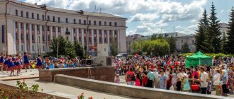
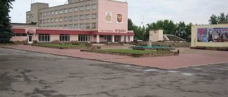
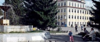
- Lenin Street - This is the central street of Nyagan. There is a museum and cultural center, a city square with a fountain, and the Eternal Flame. A few blocks from the street. Lenin is located Therapeutic Department No. 1.
- Lazarev Street - Located in the southwestern part of the city. There are industrial enterprises, a gas station, a shopping center, a department of the Federal Migration Service and the State Traffic Safety Inspectorate here.
- International Street - On the map of Nyagan with houses, it is located in the north-eastern part of the city. Here you can find shopping malls, cafes, and a children's creativity center.
- Neftyanikov Avenue - Connects the western and eastern parts of the city. Here is the city emergency medical station, military equipment in the open air, the city square and the Eternal Flame. At the intersection with Uralskaya Street there is a city clinic.