origin of name
The city of Shakhunya received its name from a nearby village, which, in turn, was named after a river that flowed nearby. The name of the river comes from the Old Russian “shaha” - deception (Shakhunya - “deceiver”). The reason for this name is the variability of the riverbed: the peat banks of Shakhunya were easily washed away by water in rain or flood, which made the construction of a permanent bridge impossible. In addition, local historian V.V. Smirnov voiced another version: the river in the old days was narrow, and it was easy to step over (“step over”) anywhere; this same version is mentioned in the Nizhny Novgorod toponymic dictionary as a legend.
Economy
The largest and city-forming enterprise of the city is OJSC “Moloko”; the company’s share in the total volume of shipped products is 44.3%. The enterprise has been operating since 1971, and since 2003 it has been an agricultural holding with eleven agricultural enterprises for receiving and processing milk; and two trading houses. Produces the Severnaya Dolina brand.
The railway, which stood at the origins of the city's history, is represented by three enterprises: a carriage depot, a locomotive depot, a container repair depot and the railway station itself. As of 2014, the wagon depot produces wheelsets and containers for wagons and repairs freight wagons.
To process forest resources, wood processing enterprises have been put into production: Agat OJSC, Shakhunsky Industrial Plant, Rubikon LLC, Profile LLC.
The area has plenty of farms, including an ostrich farm (Arfa OJSC) and a poultry farm. The first is engaged in breeding ostriches and selling eggs, while the second produces chicken eggs and meat. The city produces meat products. The Apis LLC meat processing plant produces meat from poultry, cattle, pigs, sheep, goats and horses. An ostrich farm and poultry factory produce meat and eggs.
Weaving factory (LLC "Woven Patterns").
Shakhunya (urban district)
The district borders the Vetluzhsky district, the Tonshaevsky Tonkinsky districts and the Urensky municipal district of the Nizhny Novgorod region, as well as the Kirov and Kostroma regions.
The development of the district is favored by the geographic location of the district, the Nizhny Novgorod-Kirov highway passing through the city and the Nizhny Novgorod-Kirov railway passing through the city[4]. The abundance of forests on the territory of the district makes it possible to develop the forestry and wood-chemical complex[4].
The area of the district is 2594 km². About 65% (1686 km²) of the territory is occupied by forests, free land is 908 km². The total area of farmland as of March 18, 1997 was 72,569 hectares, where arable land was 60,191 hectares, hayfields and pastures were 12,378 hectares[6].
Geology
The territory of the Nizhny Novgorod region occupies part of the East European Plain. The region is located on the foundation of the Russian Platform, with a base of granites, gneisses, and quartzites hidden under sedimentary rocks[7]. The depth of occurrence of crystalline rocks is 1000–3000 meters from the earth’s surface[7].
In the Paleozoic era, the entire surface of the Russian Platform was covered several times by seas, at the bottom of which were deposited those layers of loose rocks that make up the geological picture of the region's territory[7].
The urban district of the city of Shakhunya in the eastern and southern parts is composed of layers of the Permian period of the Paleozoic era - variegated megels and clays[7].
The water yield for wells is obtained by punching a slab from a layer of gray-green or brown-brown marls - minerals containing silicates of calcium, magnesium, aluminum and iron [7]. The thickness of the slab can range from several millimeters to tens of centimeters[7]. Between the marly layers lie sandy loams with gravel inclusions - an excellent water carrier[7].
The fairly high location of the surface of the region on the watershed of Vetluga and Vyatka (about 160 m), coupled with a close groundwater horizon, explains the abundance of small and shallow rivers originating in the urban district of the city of Shakhunya and adjacent areas of the Kirov region, and carrying their waters to Vetluga ( Bolshaya and Malaya Kakshi, Vaya, Usta), Volga (Bolshaya Kokshaga) and Vyatka (Pizhma, Oshma and Kuzhnur)[7].
The northwestern part of the district is composed of rocks of the Triassic period of the Mesozoic era - red-brown clays, marls and sandstones[7]. The floodplains of the Vetluga, Bolshaya and Malaya Kaksha rivers and the upper layers of the rest of the territory represent the youngest strata of rocks of the Quaternary period of the Cenozoic era, mainly sands, clays, and loams[7]. Such young sedimentary rocks were formed as a result of sediments during the melting of glaciers during global glaciations[7].
The territory of the Russian Platform was visited by three glaciations - Oka (500 thousand years ago), Dnieper (250 thousand years ago) and Valdai (70-10 thousand years ago)[8][7]. At the same time, the southern border of the Oka glaciation passed directly along the right bank of the Vetluga River in the upper reaches[7]. The border of the Dnieper glaciation passed more recently, through the territory of Chuvashia and Mari El, and the border of the Valdai glaciation ran north of Vologda and Kotlas[7]. During the period of melting of the last glacier, powerful streams of water flowed to the south, which eroded and smoothed out the previous sediments of earlier geological strata[7]. The rotation of the Earth shifted the flows flowing to the south to the west, which caused the corresponding direction of alluvial ridges[7].
In the territory from Kotelnich to Krasnye Baki there is a huge sandy depression[7]. This is the channel of the former continuation of the Vyatka, which flowed into the “ancient Vetluga” near Krasnye Baki, and the Vetluga, in turn, connected with the Sura, forming a powerful stream carrying its waters to the south[7]. The Volga is younger than its tributaries: the Unzha, Vetluga, and Sura and was formed later[7]. These tributaries formed a powerful river network, dug deep valleys, and some of them no longer flow (among them the valley between Kotelnich and Krasnye Baki), but they did flow recently[7]. By the way, these rivers deposited those huge sand and clay sediments[7].
Physiographic characteristics
Points[9]
| Place | Height, m[10] |
| 3 km southwest of the station. Shesterikovo | 192,0 |
| Mouth of Malaya Kaksha | 90,0 |
| Sovetskaya Square | 152,2 |
| TV tower | 173,2 |
| Weather station | 176,1 |
| water tower | 156,1 |
The edge is located between the southern slope of the Northern Uvals and the northern slope of the Yaran-Kokshay Upland and has a general slope from southeast to northwest [9]. The highest point is 192 m (Baltic system) - three kilometers south of the station. Shesterikovo[9]. The lowest - 90 m - is the edge of the Malaya Kaksha River at its confluence with Vetluga[9].
The urban district of the city of Shakhunya is located on the watershed area of the Chernaya (Chernushka) rivers and its tributaries: Samarikha and Kopani[9]. The Chernaya River begins in a lowland in the area of Sadovaya and Internatsionalnaya streets, flows into Malaya Kaksha at the Tumaninskaya rural administration[9]. Samarikha originates at the confluence of two streams at the intersection of Sadovaya and Krupskaya streets, flows into Chernaya at the former Morozovsky repair[9]. Kopan begins at the confluence of two streams in the area of canteen No. 11 ORSA GZhD, flows into Samarikha near the village of Alekhanovtsy[9].
The relief of the urban district is a slightly undulating plain, inclined to the northwest[9]. The highest point is the area of the art factory - water tower - 156.1 m [9]. Sovetskaya Square - 152.2 m. The southern part of the city rises to the southwest. TV tower: 173.2 m; weather station: 176.1 m[9].
Average elevations: Syava - 100 m, Vakhtan - 130 m. Khmelevitsy village - 140, Bolshoye Shirokoe village - 175, Chernoye village - 131 m[9].
Minerals
The urban area is rich in brick clay and peat[11].
The main resource is drinking water, the replenishable deposits of which are in some places located on the surface in the form of clean, slightly mineralized and slightly acidic springs[11]. The near-surface layer of groundwater is mineralized with calcium and magnesium ions, which impart hardness to the water, and iron ions with a weak astringent taste [11]. Deep waters (80-120 m) are highly mineralized with fluorine and have a slightly alkaline reaction. The waters of sphagnum bogs are microbiologically pure due to the antiseptic properties of sphagnum moss[11].
Some researchers believe that with proper exploration, oil can be discovered at great depths[11].
Climate
Climate characteristics[12]
| Characteristic | Meaning |
| Minimum temperature | −46 °C |
| Maximum temperature | +37 °C |
| Duration of period with below +8 °C | 226 days |
| Length of period with below 0 °C | 163 days |
| Total precipitation for the year | 548 mm |
| Max. days precipitation | 59 mm |
| Duration of snow cover | 18.10—15.04 |
| Average snow depth | 62 cm |
| Average number of calm days | 11 (January), 17 (July) |
| Receiving solar heat | 110 Watt/year |
The Shakhun region is located in a moderately cold continental climate with cold and snowy winters and moderately hot summers[12]. Minimum temperature: −46 °C (December 31, 1979), maximum: +37 °C[12]. The duration of the period with temperatures below +8 °C is 226 days, with 0 °C - 163 days[12].
In 163 days, even the ground freezes, especially if the ground is not covered with snow; in such places the ground freezes up to one and a half meters, when the ground is covered with snow only a couple of tens of centimeters[12]. The district's soil is classified as heaving soil and uneven freezing can lead to the destruction of structures[12].
Forests have a great influence on the climate: the squat layers of forest air and soil create their own microclimate. The forest is cooler in summer and warmer in winter. The forest prevents snow from blowing away in the fields - has a positive effect on crop yields - and makes the river regime more stable.
The area receives quite a lot of rainfall, but approximately once every ten years there is a dry year, bringing with it forest fires and crop failures: 1891, 1901, 1911, 1921, 1932, 1941 (not a drought, but the average annual temperature is 0 °C ), 1951, 1961, 1972[12]. Total precipitation for the year: 548 mm, maximum daily precipitation: 59 mm[12]. Duration of snow cover: from November 18 to April 15[12]. Average snow thickness: 62 cm[12]. The average number of windless days in January is 11, in July - 17[12]. The predominant winds in winter are southwestern and western in summer[12]. Every square meter of the earth's surface receives solar heat on an average annual basis: 110 Watts. The largest amount of heat is supplied in June (220 W), the smallest in December (10 W)[12].
Hydrography
Vaya is a river that originates 1 km north-west of the village of Pismener, Tonshaevsky district and flows into Usta 5 km south of the station. Arya[13]. The length is about 106 km[13]. Source: 146 m; mouth: 91 m[13].
Malaya Kaksha is a river originating 2 km west of the station. Tonshaevo (village Shaigino) and flowing into Vetluga 8 km above the town of Vetluga[13]. Length 91 km[13]. Source: 133 m; mouth: 88 m[13].
Bolshaya Kaksha is a river originating 0.5 km south of the station. Shabalino of the Northern Railway and flows into Vetluga 9 km above the city of Vetluga[13]. Length 138 km[13]. Source: 161 m; mouth: 88 m[13].
Bolshoi Vakhtan is a river that originates from the Tereshinsky settlement and flows into Bolshaya Kaksha on the left on the border with the Kirov region, 12 km above Syava[13]. Length 41 km[13]. Source: 141 m; mouth: 106 m[13].
Pizhma is a river that originates 5 km east of the village of Shcherbazh and flows into Vyatka on the right near the city of Sovetsk[13]. Length 300 km[13].
Vakhtan (Vakhtanka) is a river that originates near the village of Vakhtan-Rachki and flows into Malaya Kaksha on the right, near the former village of Trekhrechye[13]. Length 23 km[13]. Source: 131 m; mouth: 107 m[13].
Vakhtan is a river that originates near the village of Gusevsky at the confluence of two streams, starting at the villages of Meleshikha and Krasny May, and flows into Malaya Kaksha on the left opposite Khmelevitsy[13]. Length 24 km[13]. Source: 142 m; mouth: 108 m[13].
Svecha is a river that originates 1 km east of the Burenino platform and flows into Malaya Kaksha on the left 1 km below the village of Kamennsha[13]. Length 18 km[13]. Source: 120 m; mouth: 107 m[13].
Chernaya is a river that originates at the intersection of Sadovaya and International streets in the city of Shakhunya and flows into Malaya Kaksha on the left, 0.5 km north of the village of Chernaya[13]. Length 23 km. Source: 131 m; mouth: 107 m[13].
Kulepikha is a river that originates on the territory of the industrial base PMK-214 and CJSC Tarpol and flows into the Chernaya near the village of Tumanino[13]. At the mouth is the Tumaninsky pond[13].
Soils
The soils of the urban district, according to the definition of Professor Serebryannikov, belong to the soddy-podzolic type[14]. This type of soil was formed due to climatic conditions and the nature of the vegetation cover, the continental rock from which it developed and which underlies it at depth[14]. The parent rock is composed of marls, clays and sandstones covered with sandy and clayey glacial deposits. The Shakhun region has a sufficient amount of precipitation[14].
The vegetation consists of coniferous forests with an admixture of deciduous ones[14]. Fallen needles, foliage, small branches, roots and fallen trees produce humus during the process of decay[14].
The best soils of the district are those on which spruce-fir forests grow with an admixture of linden, maple, elm, elm, oak, located on watersheds and flat elevated plateaus on the slopes of rivers and streams, where the parent rock is light and medium loam with low (deep) ) groundwater occurrence[14]. The most fertile soils of varieties 5 and 5.1 in percentage terms along the edge are 70-75%[14].
Varieties
The following types of soils are located on the territory of the urban district[14]:
- Soddy-podzolic, sandy in composition. Distributed in river valleys in their middle and lower reaches. Pine forest types and lingonberry pine forests grow on them.
- Soddy-podzolic, sandy-silty in composition (coarse sand). They are distributed in low-lying wetlands of the first group of soils. Sphagnum pine forests grow on them.
- Soddy-podzolic, silty-sandy in composition (thin sandy loam). Distributed everywhere in small spots on flat, elevated plateaus. They are inhabited mainly by pine and spruce forests, as well as lingonberry pine forests.
- Soddy-podzolic coarse-silty in composition (light loams). They are distributed everywhere on flat, elevated plateaus, along light slopes of the terrain and occupy a predominant position within the urban district of the city of Shakhunya. They contain linny spruce forests with an admixture of deciduous species.
- Medium and weakly podzolic and soddy-podzolic soils, silty in composition (medium loams). Distributed throughout the ridge of uplifts. Spruce-lingonberry forests and, in the depressions, spruce-bilberry forests grow on them. Strongly podzolic soils, silty in composition (medium loams). Distributed in low areas with shallow groundwater. On them grow spruce-dolgomushnik, spruce-blueberry, and sphagnum spruce.
Architecture and landmarks
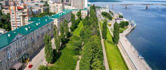
In the city center there is a cultural and shopping ensemble. In the center of the city, in 1968, Sovetskaya Square was built, adjacent to it is the former building of the House of Soviets, now the local administration building. Adjacent to the side of the square is the “My Family” shopping center, a former dismantled wide-screen cinema “October” made of glass and concrete. Opposite it is the House of Communications. Opposite the administration building there is a grocery store and a library.
The general plan of the city of Shakhunyi was approved in 1966 by the executive committee of the Gorky Regional Council of Workers' Deputies, and Lengiprogor developed a detailed plan for the city center.
Shakhunya - Cities and towns of Russia
Shakhunya is located in the north-eastern corner of the Nizhny Novgorod region, on the Nizhny-Kirov railway line.
Population 20 thousand. Established in 1921 as a station village, since 1943 - a city. We had 2 hours to get to Shakhunya, which is quite enough for this town.
A common theme is the steam locomotive monument at the station.
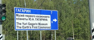
The main street, Gagarina, begins from the station. There is even an assumption as to what it was called before 1961. A fountain suddenly appeared in the park.
The ruins of a house clearly from the 1920s.
Development of Gagarin Street.
The city center is Sovetskaya Square.
Bank in a 1955 building.
Memorial. Lenin is gone.
The administration is very sad, but the cinema pleased with the painting on a revolutionary theme. They wouldn't ruin it during repairs.
After leaving the square, we wandered into the private sector, where we were pleased to see such a garage.
We went out onto Sovetskaya Street and walked towards the northern and western outskirts.
We went into some kind of wilderness, and here the most interesting thing in this city awaited us.
This interesting one turned out to be, oddly enough, a path, boldly decorated with late Soviet mosaics.
They even depicted something marijuana-like.
The driver training corps was related to the Labor Reserves society.
We return towards the center.
In such towns, where there is almost nothing for the eye to catch on, you even photograph five-story buildings.
The clinic is not bad in some ways.
Another clinic.
Before leaving, we went to the pedestrian bridge over the railway tracks, and it was so lovely!
We didn’t go to the off-line part, but took a couple of shots from the bridge.
russiantowns.livejournal.com
Monuments
Monument to fellow countrymen who fell in the Great Patriotic War. It appears to be a statue of three soldiers, one of them depicted in a fall, on a podium 2.5 meters high. In the summer of 2013, the ensemble of the monument was updated. Memorial plaques with lists of WWII participants who left Shakhunya have been replaced.
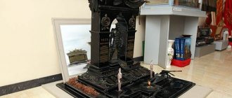
The monument to Dmitry Evlampievich Komarov is a stele on top with a bust of D. E. Komarov. Initially installed opposite the club named after M. S. Plaksin, but later [specify] moved to school No. 1.
In memory of those generations of railway workers who worked selflessly since the foundation of the depot, a steam locomotive of the “L” series with number 2162, one of the best and most popular Soviet steam locomotives, was installed for eternal parking on the station square of the Shakhunya station. It reminds us of the first generations of railway workers.
In 2011, memorial plaques dedicated to the participants of the Afghan war who studied at the school were installed in the gymnasium and secondary school No. 1. Sergei Nikolaevich Mironov, who died in Afghanistan. Awarded the Order of the Red Star.
Shakhunya and its attractions - Sutochno.ru
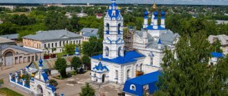
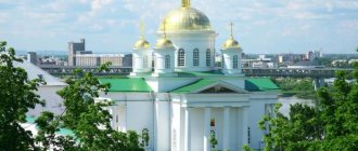
The settlement of Shakhunya is known as a city of railroad workers and logging workers. This is due to the rapid development of the railway after 1917. By 1927, a locomotive depot was built here. In memory of several generations of railway workers, a steam locomotive of the LV series, produced in 1953 in Kolomna, was installed in the station square of the city for eternal parking. There are no ancient churches in this young city. But since 1994, the Orthodox Church of the Intercession of the Mother of God has been operating on the territory of the city park. It is built in the traditional style with the altar facing east, towards the rising sun.
Since 2001, the People's Folklore and Ethnographic Museum has been operating in Shakhunya, which is located at st. Revolutionary, 24, and is open on weekdays from 8 a.m. to 5 p.m. He is well known to guests who rent accommodation for a day in Shakhunya. The museum staff conducted more than 30 expeditions, during which they collected a lot of materials telling about the ethnography and folklore of the region. The museum operates on a permanent basis the exhibition “Peasant Estate of the Late 19th and Early 20th Centuries.” Here you can see samples of homespun products from the everyday life of peasants: shirts, sundresses, belts, napkins, tablecloths.
Over time, new sections and antiquities related to the history of the Shakhun region appeared in the museum. They talk about the Shakhun people who fought on the fronts of the Great Patriotic War. A separate exhibition is dedicated to the history of the formation of Shakhunya as a railway junction. There is also mention of the development of the cooperative movement in the Shakhunsky district.
The museum staff is also studying the famous archeological monument of the 9th-11th centuries - the Veselovsky burial ground. It is located near the abandoned village of Semenovo. The first excavations were carried out here back in 1929, and 13 ancient burials were discovered. In the summer of 1957, scientists studied the burial ground more fundamentally. The finds indicate the high development of crafts.
In Shakhunya, on Sovetskaya Square, a monument was erected to the soldiers who died in the Great Patriotic War. The monument depicts three soldiers of the Soviet Army. One of them is wounded, but still stands, leaning on his comrade's shoulder. As you might guess, this monument is especially revered by local residents and guests of the city - there are always a lot of flowers here on holidays.
We invite you to Shakhunya: extraordinary nature and interesting places will provide a lot of impressions. Welcome!
March 31, 2021 Tags: Attractions , What to see
shahunya.sutochno.ru
Education and science
There are 7 municipal kindergartens in the city
- Municipal educational institution Shakhunskaya secondary school No. 1 named after. D. E. Komarova with a teaching staff of 40 people. In 2012, the school turned 75 years old, and the first graduate was in 1940. During its existence, the school has had 8 directors. In accordance with the License, the school implements educational programs at three levels of education.
- MBOU "Shakhun Gymnasium named after. A. S. Pushkin" with a teaching staff of 38 people[69]. Created in 1994. An institution of higher status implements programs of primary general, basic general and secondary (complete) education, as well as additional education and programs for in-depth study of the Russian language, literature and English.
- Municipal educational institution Shakhunskaya secondary school No. 14 was founded in 1919. Since 2000, a science and mathematics class has been opened. Municipal educational institution Secondary School No. 14 is rightfully considered the largest school in the area. Currently there are more than 700 students. About 60 first-graders come to school every year. Graduates of the school enter leading universities in Russia. Municipal educational institution Shakhunskaya secondary school No. 2 has been operating since 1962.
- GBOU SPO "Shakhun Agro-Industrial College" was founded in 1941 as the Railway School. It has three branches in Tonkino, Uren and Sharanga. At the economic base there is a branch of the Nizhny Novgorod University named after. Lobachevsky.
Shahunya – Mycicerone – travel and tourism in cities and countries
Material from Mycicerone - travel and tourism in cities and countries
[edit] A little about Shakhunya
Shakhunya is a district center in the northeast of the Nizhny Novgorod region of Russia, located 250 km along the highway northeast of Nizhny Novgorod, on the banks of the Samarikha and Kopani rivers, which flow into the Chernaya River on the outskirts of the city.
[edit] Districts of Shakhunya
[edit] How to get to Shakhunya
[edit] by plane
[edit] by train
[edit] by bus
[edit] by car
[edit] on the ship
The rivers are not navigable.
[edit] City transport Shakhunya
[edit] Hotels in Shakhunya
Address: Nizhny Novgorod region, Shakhunya, Yaranskoe highway, 4 Telephone: +7(83152)2-47-65 Description: Address: Nizhny Novgorod region, Shakhunya, Karl Marx street, 182-A Telephone: +7(83152)2-47- 60 Description:
[edit] Sights of Shakhunya
- Lenin monument.
- Monument to those who fell in the Great Patriotic War of 1941-45.
- Orthodox Church of the Intercession, built in the 1990s in a city park.
- A chapel in memory of soldiers who died in local conflicts, built in 2005 next to the Church of the Intercession.
- Steam locomotive-monument of the LV series at the railway station.
- Bust of Hero of the Soviet Union Dmitry Evlampievich Komarov (1922-44).
[edit] Museums in Shakhunya
- Shakhun National Folklore and Ethnographic Museum
Address: Nizhny Novgorod region, Shakhunya, Revolyutsionnaya street, 24 Telephone: +7(83152)2-74-31 Opening hours: Tickets: Description: Address: Nizhny Novgorod region, Shakhunya, Sovetskaya street, 15 Telephone: +7(83152)2- 70-53 Opening hours: Tickets: Description:
[edit] Entertainment in Shakhunya
Address: Nizhny Novgorod region, Shakhunya, Chapaeva street, 2-A Telephone: +7(83152)2-77-33 Opening hours: 8:00-22:00 Tickets: Description: The sports complex has a cinema hall, a cafe, an ice skating rink, a gym and two swimming pools, one of which has a water slide.
[edit] Information on the Internet about Shakhunya
- admshaharea.ru - website of the city and district Administration
- shahunia.ru - old website of the City Administration
www.mycicerone.ru
Transport
The city's transport system is represented by the following modes of transport: railway, road, taxi. There are developed suburban and intercity bus and train services. There is a railway station in Shakhunya. In close proximity to the city there is a regional highway P159 connecting Nizhny Novgorod and Yaransk. The Nizhny Novgorod - Kotelnich railway route is through and passenger branded trains currently run along it.
Street and road network
The city of Shakhunya has a rectangular road network. The advantage of this scheme is the absence of a clearly defined central transport hub, a relatively uniform traffic load on all streets and the high throughput of the entire system as a whole, due to the presence of redundant connections. The disadvantage of the scheme is the lack of the shortest connections in the most active diagonal directions, but this disadvantage does not have a significant impact on the functioning of the urban transport system as a whole.
The city's public transport is represented by bus and taxi. The urban transport network has a developed part that connects all parts of the city with each other: from the village of Yanvari to the village of Krasny Kirpichnik. From the Yaranskoe highway to the Leskhoz microdistrict.
The main attractions of Shakhunya
Anyone going on a trip makes a list of attractions in Shakhunya that they must visit. Some plan independent routes to explore the city, others book special walking or bus excursions. They usually cover the main attractions of Shakhunya and give an idea of the historical and cultural development of the city.
Connoisseurs of creativity always strive to find sculptural attractions on the map of Shakhunya. In the main squares of the city you can often see iconic sculptural compositions, against which city guests pose. But in parks beloved by the local population, you can see exhibitions of ultra-modern sculptures and art objects. They can be made from the most unpredictable materials and have unimaginable shapes that you will need to think about more.
Among the main attractions of Shakhunya, religious sites occupy a special place. They are the center of the architectural ensemble of the city in Russia, most of them survived significant religious and historical events. In Shakhunya and outside the city, you can visit the famous monasteries, soak in the beauty of large Orthodox cathedrals, or go to the modest and miniature chapels that are so popular among the city’s residents.
Traveling around the area, you can still see special religious sites. These could be national religious buildings, ancient places of worship, or even mysterious ritual places.
Pedestrian promenades along Shakhunya have a special romance. You can purchase a map of Shakhunya in advance with attractions and routes, or even wander where you like. This will make it even more exciting. Let yourself get lost in the ancient alleys or wander through the squares. And if you get tired, you can have a snack or taste coffee in some pleasant cafeteria. By the way, in Shakhunya there are a couple of famous places where every tourist hopes to get to.
If you intend to fully explore the city's history and modernity, welcome to the museum institutions of Shakhunya. They store rich exhibitions on ethnography, art, folk arts and crafts, from archaeological expeditions. Most often, such attractions are located in the center.
At the same time, thematic open-air museums can often be seen in the countryside. They present interesting exhibitions that convey the atmosphere of local color and present products of folk arts and crafts. Moreover, this can be a format of realistic recreation of ancient cities or military forts. Such attractions in Shakhunya will be very educational for children.
For tourists traveling with families, the question is always relevant: where to go with children. The most popular offer is to go to one of the Shakhunya aquatic complexes. Most often, discounted rates apply when ordering a family ticket for the whole day.
If you are traveling in winter or spring, we recommend considering the Shakhunya ski resorts for active leisure. This place has a lot of activities for children and parents: a variety of ski and snowboard slopes, snow tubing, and exciting snow parks for the pros. Often such centers are located not very far from the city. In this regard, it is more convenient to get there by your own car or book a car rental office.
An excellent idea for a family vacation is an active holiday in nature. These attractions are usually located near Shakhunya. These can be rivers, gorges, famous protected areas. You just need to decide on a place. These natural attractions can be reached either independently or by public transport. Find out in advance the routes of shuttle buses departing from city bus stations in the direction you need. On such a trip you will get a lot of unforgettable emotions from being in nature and restore your moral and physical strength.
If you arrived in the city on work matters, then you do not have free time for full-fledged excursion programs. In such a situation, we recommend that you find a condensed index of Shakhunya attractions with photos and descriptions.
You can always look for such a guide upon arrival in the city at the railway stations or at the air terminal. This guide provides a list of the most iconic places to visit in Shakhunya, with names and photos of attractions. Isn’t it true, this greatly simplifies the task of what to see in Shakhunya, especially if you have little time.
However, if the guidebook contains the most popular corners of Shakhunya, then on the Internet there is a chance to find a rating of unfamiliar, but no less interesting attractions with reviews of tourists who visited them. Abandoned quarries, mysterious craters, ancient narrow-gauge railways, overpasses - such sights attract adventure lovers.
When planning a trip to Shakhunya, we recommend that you find out not only about the attractions, but also about other city infrastructure facilities. To move around the city, it is good to know the public transport traffic pattern, the location of railway and bus stations or ports, and metro stations. At the same time, such important public buildings of Shakhunya can become objects of tourist interest. Often they are the ones who form the first impression of a locality on a visitor’s part.
Show more
akuaku.ru
Suburban and intercity buses
Suburban and intercity buses leave from the bus station, which is located next to the train station. There is a developed route connection with all cities and towns of the urban district of the city of Shakhunya, as well as intercity flights to the cities of Yaransk and Vakhtan. Buses do not go to large cities (Kirov, Nizhny Novgorod, Yoshkar-Ola). These routes run along suburban railway lines.
Buses for the city are provided by the Passenger Motor Transport Enterprise (PAP).
Shakhunya
(Nizhny Novgorod Region)
OKATO code:
22458
Founded:
1921
Urban-type settlement since:
1933
City since:
1943 City of regional subordination
Center:
Shakhunsky district
Urban-type settlements, population as of 01/1/2021
| Vakhtan | 4.6 | Syava | 3.5 |
| Telephone code (reference phone) | |
| 83152***** | 22-1-21 |
Deviation from Moscow time, hours:
0
Geographic latitude:
57°40′
Geographic longitude:
46°37′
Altitude above sea level, meters:
150 Sunrise and sunset times in the city of Shakhunya