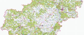
The Voronezh region is geographically located in the central zone of Russia. A satellite map of the Voronezh region clearly demonstrates that the city occupies an advantageous location in terms of transport routes.
The map helps you find any object on the territory. It displays the geographical location of settlements and their actual areas.
With its help, you can’t get lost in the numerous city streets.
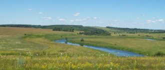
The map of the Voronezh region shows that the region is located in the upper reaches of the Don River. Several large rivers flow through the region. This region is especially popular among fishermen. There are many ponds and reservoirs with fish.
The region is distinguished by the richest black soils and large industrial enterprises.
Central districts in the Voronezh region on the map
There are many districts on the map of the Voronezh region. The central areas include:
- Borisoglebsky district has been included in the region since the 1930s. On its territory you can find such large enterprises as an iron foundry, a meat-packing plant, and a heating systems plant.
- On the Central Russian Upland there is the Ostrogozhsky district . Sand, chalk and clay are mined in its lands. The district includes more than 80 settlements. A map of the Voronezh region by district will help you find them all. The region has a variety of agricultural, farming, and large industrial enterprises. There are also large transport and construction companies on its territory. The area is known for its unique natural attractions: chalk pine trees, steppe slopes near the village of Vladimirovka and floodplains near the Tikhaya Pine River. You can also visit interesting archaeological sites in the area.
- In the southwest is the Rossoshansky district , it can be found with a detailed map of the Voronezh region. There are more than 75 agricultural enterprises in the region. An important railway line runs through the city.
- Liskinsky district is considered one of the central districts of the region . There are about 15 large organizations in the area. There are 11 companies involved in manufacturing. Among them it is worth noting Liski Sugar and Bread, as well as Metallist, Garden and Liski Printing House. Agricultural industry is considered one of the leading industries. Using the road map of the Voronezh region, you can find various farms or households. Areas with mineral water were found here. The area is also rich in various attractions: the Cathedral of the Blessed Virgin Mary, various monuments, as well as a museum with a protected area - Divnomorye.
Administrative-territorial division of the Voronezh region
Voronezh region, administrative territorial unit (subject) within the Russian Federation. Included in the Central Federal District and the Central Black Earth economic region. From north to south it extends from 52°06′ to 49°36′ northern latitude (277.5 kilometers), from west to east from 38°06′ to 42°06′ east longitude (352 kilometers). The administrative center is the city of Voronezh.
The Voronezh region was formed on June 13, 1934 during the liquidation of the Central Black Earth Region and its division into the Voronezh region and the Kursk region.
The Voronezh region included 89 districts. In 1937, with the formation of the Oryol, Tambov and Ryazan regions, 44 districts were transferred to them. In 1940, the borders with the Kursk region were changed. The boundaries of the Voronezh region were changed in 1954 in connection with the formation of the Kamensk region, Balashov region, Lipetsk region and Belgorod region. In 1957, in connection with the liquidation of the Kamensk and Balashov regions, the districts that belonged to these regions at the time of their formation were returned to the Voronezh region. Since 1957, the boundaries of the Voronezh region have remained unchanged, but until 1977, changes were made to the regional division.
The Voronezh region borders in the east with the Saratov region and the Volgograd region, in the south with the Rostov region and Lugansk region (LPR), in the west with the Belgorod region and Kursk region, in the north with the Lipetsk region and Tambov region.
In accordance with the Law of the Voronezh Region of October 27, 2006 “On the administrative-territorial structure of the Voronezh Region,” the region’s territory is divided into 31 municipal districts (Anninsky, Bobrovsky, Bogucharsky, Buturlinovsky, Verkhnemamonsky, Verkhnekhavsky, Vorobyovsky, Gribanovsky, Kalacheevsky, Kamensky, Kantemirovsky, Kashirsky, Liskinsky, Nizhnedevitsky, Novousmansky, Novokhopyorsky, Olkhovatsky, Ostrogozhsky, Pavlovsky, Paninsky, Petropavlovsky, Povorinsky, Podgorensky, Ramonsky, Repyovsky, Rossoshansky, Semiluksky, Talovsky, Ternovsky, Khokholsky, Ertilsky), as well as Borisoglebsky urban district, Voronezh urban district, urban district city of Novovoronezh.
The Voronezh region includes 15 cities (Voronezh, Bobrov, Boguchar, Borisoglebsk, Buturlinovka, Kalach, Liski, Novovoronezh, Novokhopyorsk, Ostrogozhsk, Pavlovsk, Povorino, Rossosh, Semiluki, Ertil), 4 urban-type settlements (Anna, Gribanovsky, Kamenka, Podgorensky), 17 working villages (Davydovka, Elan-Kolenovsky, Kantemirovka, Krasnolesny, Latnaya, Nizhny Kislyai, Novokhopyorsky, Olkhovatka, Panino, Pereleshinsky, Pridonskoy, Ramon, Somovo, Strelitsa, Talovaya, Khokholsky, Shilovo), more than 1,700 rural settlements .
The area of the Voronezh region is 52,400 km2.
Population composition: 93% - Russians. There are also Ukrainians (about 75,000 people), Armenians (about 9,000 people), Belarusians (about 5,000 people), Jews (about 1,500 people) and representatives of other nationalities. The urban population is 62%, about 46% of the population are men, 54% are women. The working population is about 60%. The average population density of the Voronezh region is 43.75 people per 1 km2.
Population: 2 472 800 (1981), 2 378 800 (2002), 2 277 600 (2008), 2 331 147 (2015).
The coat of arms and flag of the Voronezh region were approved on July 5, 2005.
The charter (basic law) of the Voronezh region, adopted on June 7, 2006 (additions made on April 4, 2007), determines: legislative power is exercised by the regional Duma, consisting of 56 deputies elected for 5 years. Of these, 28 deputies are elected in single-member districts and 28 in a single district according to party lists. The highest executive body is the administration of the Voronezh region, headed by the governor.
Municipal districts of the Voronezh region
Urban district of Voronezh
Borisoglebsky urban district
Urban district city of Novovoronezh
Anninsky municipal district
Bobrovsky municipal district
Bogucharsky municipal district
Buturlinovsky municipal district
Verkhnemamonsky municipal district
Verkhnekhava municipal district
Vorobyovsky municipal district
Gribanovsky municipal district
Kalacheevsky municipal district
Kamensky municipal district
Kantemirovsky municipal district
Kashirsky municipal district
Liskinsky municipal district
Nizhnedevitsky municipal district
Novousmansky municipal district
Novokhopyorsky municipal district
Olkhovatsky municipal district
Ostrogozhsky municipal district
Pavlovsky municipal district
Paninsky municipal district
Petropavlovsky municipal district
Povorinsky municipal district
Podgorensky municipal district
Ramonsky municipal district
Repyovsky municipal district
Rossoshansky municipal district
Semiluksky municipal district
Talovsky municipal district
Ternovsky municipal district
Khokholsky municipal district
Ertil municipal district
Map of the Voronezh region with cities and villages
By selecting routes of the Voronezh region on the map, you can visit cities with interesting history.
These include the following settlements:
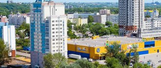
- On the site of Voronezh there used to be a Cossack village. This city has a developed manufacturing sector. On its territory there is a ceramic factory, a car repair company and an organization that produces medications. Also, the map of the Voronezh region describes in detail the largest enterprise in Russia that produces furniture. This is Black Earth Furniture. Recently, many entertainment and shopping complexes have been built in the city. There are more than 60 different markets in the city. The city center is home to magnificent historical sites. The Arsenal is considered the oldest museum in the city. Petrovsky Square with a fountain, a bronze statue and beautiful trees is considered an interesting place for walking.
- Borisoglebsk is considered one of the largest cities in the region. With a map of the Voronezh region with cities in good quality, you can see all the sights of the urban area. It is a city with many green spaces and small buildings.
- Rossosh is a city surrounded by forests where wild animals live. The city is considered an important railway center and is known for its chemical and food industries.
- A map of the Voronezh region with cities and villages will allow you to find the city of Liski. Many new buildings are appearing in the city. From Voronezh to the city it is about 115 km. The city has companies producing pipelines and metal structures. The city also has a river port and railway enterprises.
- It is worth highlighting Ostrogozhsk. It is famous for its tannery and numerous food processing plants.
Voronezh region. Districts
Located in the central European part of the Russian Federation. The area of the region is 52,216 square meters. km, its population is 2,331,506 people, of which 95.5% are Russian. The population density is about 44 people per sq. km. The administrative center is the city of Voronezh with a population of 1 million people. The largest cities in the region: Borisoglebsk, Rossosh, Ostrogozhsk, Liski, Novovoronezh.
The relief of the Voronezh region is predominantly flat, most of it is forest-steppe, and in the southeast there is steppe. The largest river: Don, in total there are 1343 rivers in the region, including Bityug, Voronezh and Khoper, many lakes and artificial ponds. They contain a huge variety of fish; on the banks there are a lot of recreation centers, sanatoriums, and nature reserves. The most interesting tourist site: Divnogorye. This is a unique Orthodox church, carved by monks inside a huge chalk mountain.
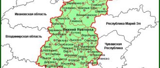
Voronezh region. Map (The dotted line indicates the boundaries of the area on the map)
The region has large reserves of chalk, many deposits of non-metallic raw materials and phosphorites. In the near future it is planned to begin developing deposits of nickel, copper and platinum. The main industries are food, engineering and electricity. Voronezh is considered the capital of the Black Earth Region, and the land itself is the main resource here. It borders with the Lugansk region of Ukraine, 7 regions of Russia: Belgorod, Volgograd, Kursk, Lipetsk, Rostov, Saratov and Tambov. It is divided into 31 municipal districts, as well as 3 urban districts. There are 29 cities and 471 rural settlements on the territory.
Districts of the Voronezh region:
|
|
|
Administrative-territorial division of the Voronezh region Map by district
Cities and towns:
Voronezh Borisoglebsk Liski Ostrogozhsk Novovoronezh Semiluki Pavlovsk Novaya Usman Kalach Bobrov Rossosh Buturlinovka
Transport links, roads and routes
On the map of the Voronezh region with its districts you can see a well-developed transport infrastructure. There are 17.62 thousand km of roads in the region. Among them are highways of federal and republican significance:
- M4 "Don";
- M6 "Caspian";
- A144;
- P193.
The length of railway tracks in the region is 1.5 thousand km. The main airport of the region is located 5 km from Voronezh. River navigation is carried out along the Don and Khoper rivers. They are clearly visible on the satellite map of the Voronezh region. The length of the water corridor along it is 573 km.