Shopping arcades
The city of Slobodskaya is the most developed industrial and commercial center in Russia. In the 19th century, a large number of commercial and industrial enterprises operated in it.
During the heyday of market relations in the city, shopping arcades were created that stretched over the entire quarter. Currently, they belong to the main architectural heritage of the city.
Location: Sovetskaya street - 64.
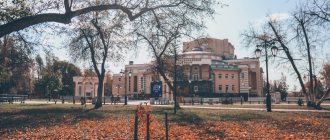
Children's Park named after A.S. Pushkin
For the centennial anniversary of Alexander Pushkin, a children's park was opened in Slobodskoye. After the October Revolution, the park came under the patronage of Komsomol members. They improved the square by planting birch trees on its territory.
Park named after Pushkin became a children's theater in 1957. And 13 years later, monumentalist Vasily Ryazantsev made a sculpture of A.S. Pushkin. The monument was erected on June 6, the poet’s birthday.
For the 110th anniversary, the park was improved: a fence and a street stage were erected, a children's playground was reconstructed, a fountain-pool was built, sidewalks were repaired, and a family cafe appeared in it.
Nativity of Christ Slobodskaya Convent
The monastery was opened in the 17th century. It is a convent that has a long history. In 1764 the temple was abolished, and thirteen years later it was restored. The merchant Potapiy Shmelev played a major role in its construction. The original name of the monastery was Spassky Monastery. In the 30s of the 20th century, services in the temple stopped. Its restoration began only in 2013.
The walls of the monastery contain a copy of the miraculous icon of the Mother of God. There is a belief that she healed an 18-year-old mute youth. After the miracle happened, all the residents of the city prayed and worshiped this shrine. Currently, the monastery is active.
Location: Nikolskaya street - 6.
Embankment Street
In the 80s, Naberezhnaya Street was a favorite vacation spot for city residents. However, over time, its infrastructure collapsed. Therefore, in 2013, in an open online vote, city residents chose a reconstruction project with the symbolic name “Embankment of Hope.”
As part of it, the rotunda on Stepan Khalturin Street and the paths along the alley of Naberezhnaya Street were repaired. The renovation was timed to coincide with the anniversary of Victory in the Second World War. Now this is again the most picturesque place in the city and, as before, tourists and Sloboda residents walk here. Additionally, Promenade of Hope is a popular date spot.
Cathedral of Catherine the Great Martyr
The cathedral is one of the main architectural heritage of the city. Previously, on the site of the modern temple there was an ordinary wooden church, erected back in 1699. Gradually the cathedral was transformed and turned into a real stone work of art. Its rich decorative decoration, typical of the 17th century, cannot but delight.
The temple functioned until 1940, but during the Second World War it ceased to function. The cathedral began to be used for military purposes. After the end of the war, the temple was revived again. The local population took an active part in its construction. People sacrificed their personal savings and even donated their icons to the temple.
Location: Volodarsky street - 54.
Population
| Population | ||||||
| 1989[6] | 2002[7] | 2009[8] | 2010[9] | 2011[10] | 2012[11] | 2013[12] |
| 43 608 | ↘37 234 | ↘35 224 | ↘34 460 | ↘34 448 | ↘34 332 | ↘34 070 |
| 2014[13] | 2015[14] | 2016[15] | 2017[16] | 2018[17] | 2019[18] | 2020[19] |
| ↘33 981 | ↘33 943 | ↘33 829 | ↘33 115 | ↗33 251 | ↘32 841 | ↘32 342 |
| 2021[1] | ||||||
| ↘31 912 | ||||||
Cathedral of the Descent of the Holy Spirit
The cathedral is located in the very center of the city of Slobodskaya. The construction of the temple was carried out in the period from 1861-1865. This single-domed temple is located almost on the banks of the Vyatka River.
The initiator of the construction was the merchant V.V. Alexandrov. This cathedral was one of the most beautiful monasteries in the city, but in the 30s of the 20th century it was partially destroyed by order of the authorities. Until 2011, the temple was used as a fur warehouse. Over time, it was completely restored and restored. Currently, the temple is operational.
Location: Sovetskaya street - 110.
Map
| Slobodskaya: maps |
Slobodskoy: photo from space (Google Maps) Slobodskoy: photo from space (Microsoft Virtual Earth)
| Slobodskaya. Nearest cities. Distances in km. on the map (in brackets along roads) + direction. Using the hyperlink in the distance , you can get the route (information courtesy of the AutoTransInfo website) | |||
| 1 | Vakhrushi | 9 (12) | Z |
| 2 | Kirovo-Chepetsk | 20 (69) | SW |
| 3 | Kirov | 33 (33) | Z |
| 4 | White Kholunitsa | 40 (39) | IN |
| 5 | Murygino | 42 (54) | Z |
| 6 | Yurya | 63 (91) | NW |
| 7 | Pervomaisky | 64 () | NW |
| 8 | Zuevka | 65 (77) | SE |
| 9 | Kumeny | 69 (100) | YU |
| 10 | Orichi | 74 (77) | SW |
| 11 | Nagorsk | 75 (85) | NE |
| 12 | Orlov | 77 (97) | Z |
| 13 | Fallonki | 90 (107) | SE |
| 14 | Suna | 98 (121) | YU |
| 15 | Verkhoshizhemye | 101 (110) | SW |
| 16 | Murashi | 101 (139) | NW |
| 17 | Bogorodskoye | 104 (148) | YU |
| 18 | Omutninsk | 115 (138) | IN |
| 19 | Kotelnich | 117 (144) | SW |
| 20 | Oriental | 118 (152) | IN |
a brief description of
Located on the high right bank of the Vyatka (navigable in high water), 35 km northeast of Kirov. Railway station.
In 1970, Slobodskoy was included in the list of historical cities of Russia. The urban planning value of its heritage is assessed at the regional level. In 2010, it was excluded from the list of historical cities.
Territory (sq. km): 49
Information about the city of Slobodskaya on the Russian Wikipedia site
Historical sketch
The first mention of a Russian fortified point dates back to 1505. It was founded at the beginning of the 16th century. as a settlement from the town of Shestakova located 25 km away (now the village of Shestaki), the settlement was originally called simply Sloboda, i.e. “a village whose residents are exempt from any duties, taxes, etc.” Later it was called Slobodskaya town.
Since 1562 Slobodskaya Posad. City of Slobodskaya since 1599
In 1708, the Vyatka suburb of Slobodskaya was assigned to the Siberian province, since 1719 in the Vyatka province. Since 1727 in the same province of the Kazan province. Since 1780, the district town of Slobodsky of the Vyatka governorate (since 1796 - Vyatka province).
From the end of the 18th century. Slobodskoy is a stronghold on the trade route from Arkhangelsk to Vyatka. Some goods, incl. fur and leather settled in Slobodskoye, which led to the emergence of the leather and fur industry.
In 1856, in the district town of Slobodskaya Vyatka province, there were 9 churches, 779 houses, 87 shops.
At the beginning of the 20th century. In terms of industrial output, Slobodskoy occupied 1st place in the province, was an exporter of leather, sheepskin and fur products, vodka, matches, and the products of Slobodsk craftsmen were known - bells and samovars.
Municipal indicators
| Index | 2001 |
| Demography | |
| Number of births, per 1000 population | 8.3 |
| Number of deaths, per 1000 population | 16.8 |
| Natural increase (decrease), per 1000 population | -8.5 |
| Standard of living of the population and social sphere | |
| Average monthly nominal accrued wages, rub. | 2359 |
| Average housing area per inhabitant (at the end of the year), sq.m. | 19.6 |
| Number of preschool institutions, pcs. | 13 |
| Number of children in preschool institutions, thousand people | 1.7 |
| Number of daytime educational institutions (at the beginning of the school year), pcs. | 9 |
| Number of students in daytime educational institutions, thousand people | 4.99 |
| Number of doctors, people. | 50 |
| Number of nursing staff, people. | 162 |
| Number of hospital institutions, pcs. | 5 |
| Number of hospital beds, thousand units | 0.2 |
| Number of medical outpatient clinics, pcs. | 3 |
| Capacity of medical outpatient clinics, visits per shift, thousand units. | 0.2 |
| Number of registered crimes, pcs. | 797 |
| Economy, industry | |
| Number of enterprises and organizations (at the end of the year), pcs. | 447 |
| Construction | |
| Volume of work performed by type of activity “Construction” (until 2004 - volume of work performed under construction contracts), million rubles. | 9.1 |
| Commissioning of residential buildings, thousand sq.m. of total area | 1.5 |
| Commissioning of residential buildings, apartments | 0 |
| Commissioning of preschool institutions, places | 0 |
| Commissioning of educational institutions, places | 0 |
| Commissioning of hospital facilities, beds | 0 |
| Commissioning of outpatient clinics, visits per shift | 0 |
| Transport | |
| Number of bus routes (in intracity traffic), pcs. | 6 |
| Number of passengers transported by buses per year (in intracity traffic), million people. | 14.3 |
| Trade and services to the population | |
| Retail trade turnover (in actual prices), million rubles. | 498.6 |
| Retail trade turnover (in actual prices), per capita, rub. | 13018 |
| Public catering turnover (in actual prices), million rubles. | 20.4 |
| Volume of paid services to the population (in actual prices), million rubles. | 202.2 |
| Volume of paid services to the population (in actual prices), per capita, rub. | 5279.2 |
| Volume of household services to the population (in actual prices), million rubles. | 84.4 |
| Volume of household services to the population (in actual prices), per capita, rub. | 2204.2 |
| Investments | |
| Investments in fixed assets (in actual prices), million rubles. | 86.1 |
| Share of investments in fixed assets financed from budgetary funds in the total volume of investments, % | 0 |
Data sources:
- Regions of Russia. Main characteristics of the constituent entities of the Russian Federation: statistical collection. Goskomstat of Russia. - M:, 2003.
Economy
Leather and fur industry (one of the largest fur factories in the country is Belka).
Plywood mill, match factory, furniture factory, distillery, pasta and confectionery factory. Production of building materials, lumber, wood.
In the Slobodsky district, rye, wheat, barley, oats, peas, potatoes and other vegetables and fodder crops are grown. Cattle are raised.
Deposits of limestone (Chirkovskoe), marl, sand, ocher.
Main enterprises
PLYWOOD PRODUCTION
OJSC "Plywood Mill 'Red Anchor'"
613100, Kirov region, Slobodskoy, st.
Sovetskaya, 132 Offers:
Glued plywood, veneer, wooden containers
FURNITURE INDUSTRY
OJSC "Slobodskoy Furniture Plant"
613100, Kirov region, Slobodskoy, st.
Yana Rainisa, 11 Offers:
Cabinet furniture, mirrors
PRODUCTION OF MATCHES
OJSC "Slobodskaya Match Factory 'Belka'"
613100, Kirov region, Slobodskoy, st.
Slobodskaya, 53 Offers:
Matches, corrugated cardboard containers
FUR INDUSTRY
Slobodskoye OJSC "Belka"
613100, Kirov region, Slobodskoy, st.
Academician Bakuleva, 4 Offers:
Men's, women's, children's fur clothing and hats
FOOTWEAR INDUSTRY (EXCEPT RUBBER FOOTWEAR)
OJSC "Union of Vakhrushevsky Enterprises"
613110, Kirov region, Slobodskoy district, urban-type settlement Vakhrushev, st.
Lenina, 5 Offers:
Men's, women's, children's, work shoes, safety shoes
Culture, science, education
The writer A.S. was born in Slobodskoye. Green (Grinevsky), lived the surgeon A.N. Bakulev.
Universities of the city
Slobodskaya branch of the Vyatka Socio-Economic Institute
613150, Kirov region, Slobodskoy, st. Stepana Khalturina, 16 WWW: https://www.sfvsei.ru/
Museums, galleries, exhibition halls
House-Museum of Jan Rainis 613100, Kirov region, Slobodskoy, st.
Vyatskaya, 24 Museum-Estate of Academician A.N. Bakulev 613152, Kirov region, Slobodskoy district, village of Bakuli
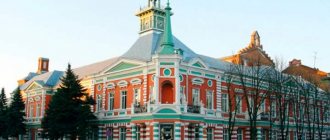
Slobodskoy Museum of Local Lore 613150, Kirov region, Slobodskoy, st. Sovetskaya, 64 Phone(s): (883362) 4-1939 4-1267
Architecture, sights
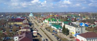
The main city street stretches along the “sovereign road to Siberia.” The main buildings in the old part of the city are wooden houses from the 19th - 20th centuries.
In the 1780s. Slobodskoy received a regular layout with a rectangular grid of streets.
The chambers of the Anfilatov merchants (1775), the Annunciation Church (1784; now the Museum of Local Lore) and the bell tower (1823). Catherine's Church (1699) with an extension (1914). Orphanage house (first half of the 19th century).
The remains of the Verkhne-Chepetsky Monastery (founded at the end of the 16th century) with a passage tower, gate church (1610-13) and gates (18th century, classicism) have been preserved.
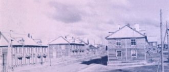
Residential areas in the 1950s-80s. built up mainly with 5-story buildings.
In 1966, a reinforced concrete bridge was erected across the Vyatka River.
| Population by year (thousands of inhabitants) | |||||||
| 1856 | 5.9 | 1979 | 36.9 | 2006 | 35.3 | 2016 | 33.3 |
| 1897 | 10.1 | 1989 | 39.2 | 2007 | 35.1 | 2017 | 33.1 |
| 1913 | 11.0 | 1992 | 39.2 | 2008 | 34.9 | 2018 | 32.8 |
| 1926 | 10.9 | 1996 | 39.8 | 2010 | 34.3 | 2019 | 32.4 |
| 1931 | 12.2 | 1998 | 35.0 | 2011 | 34.0 | 2020 | 31.9 |
| 1939 | 22.8 | 2000 | 34.6 | 2012 | 33.8 | 2021 | 31.5 |
| 1959 | 30.8 | 2001 | 34.4 | 2013 | 33.6 | ||
| 1967 | 34 | 2003 | 33.5 | 2014 | 33.5 | ||
| 1970 | 34.4 | 2005 | 32.4 | 2015 | 33.4 | ||
Literature
- Krogius V.R.
Historical cities of Russia as a phenomenon of its cultural heritage. M.: Progress-Tradition, 2009. p. 121 - Pospelov E.M.
Geographical names of the world: Toponymic dictionary: About 5000 units. M.: Russian dictionaries, Astrel Publishing House LLC, AST Publishing House LLC, 2001. p. 388 - Ch.
ed. Gorkin A.P. Geography of Russia: encyclopedic dictionary. M.: Great Russian Encyclopedia, 1998. p. 541 - Ch.
ed. Lappo G.M. Cities of Russia: encyclopedia. M.: Great Russian Encyclopedia, 1994. pp. 424-425
Memorial "Eternal Flame"
In the central part of the city there is a monument that was erected in memory of the soldiers who died during the Second World War. This monument was erected in a picturesque area. There is peace and quiet all around. Both local residents and tourists love to walk in this peaceful environment.
In the center of the memorial stands a monument to a Soviet soldier, and in front of it the Eternal Flame burns. The memorial complex was installed in 1967. It reminds city residents of their fellow countrymen who have returned home. The brutal war claimed many lives of officers and soldiers. But their memory will forever remain in our hearts.
Location: square at the intersection of Volodarsky and Vyatskaya streets.
Village Sloboda
This is a very old settlement, founded by Afanasy Gilev and Frol Arapov, who came from Verkhoturye in 1651. But a year later, all the buildings were burned by the attacking Bashkirs. However, the settlers rebuilt. To protect against raids, a fort was built in 1674.
During one of our visits to Sloboda, a local resident told us about numerous finds of arrowheads in his garden. They remind us of those turbulent times.
At the beginning of the 18th century, a state-owned pier was founded at the mouth of the Utka River. In 1703, the first caravan of 40 barges with the products of factories was sent from the Utkinskaya state pier. The pier existed for more than two centuries and was closed in 1905.
By the way, V.N. Tatishchev considered Chusovskaya Sloboda as one of the options for establishing the mining capital of the Urals. But in the end, a place was chosen on the Iset River.
The main attraction of the village is St. George's Church. Many consider her the most beautiful in the Urals. The church is unusual in that it stands right on a cliff, above the Chusovaya River. Nearby, a pedestrian bridge built in 1961 spans the river, connecting the two parts of the village.
At first there was a wooden church on this site. In 1806, construction of the stone building began. Construction took a long time. The church was consecrated only in 1831. The church building received its modern shape by 1894, when the construction of the bell tower was completed.
During Soviet times, the church did not go bankrupt. This is also why many believers from all over the area come here.
There is a small but interesting cave in the rock below the church. You can only get into it in winter on ice or in summer from a boat. There is one grotto inside, which you can crawl around. Height is less than a meter. The cave is unusual in that there are three entrances to it: two from the water and one (very small) from the side of the rock. The floor is covered with clay. There is a legend that this clay has healing properties.
Monument to the Bakulev merchants
The opening of the monument took place in the fall of 2013. It is dedicated to the Bakulev merchants, who were the founders of the bell foundry. It was this production that became the calling card of the city.
The Bakulev merchant family many years ago created an enterprise that was engaged in the production of church bells. Three centuries later, and to this day it continues to function, only now as a large engineering plant.
The opening of the monument took place during the celebration of Mechanical Engineers' Day. The monument is a large bell. Its height and diameter are 3 meters. Once upon a time, the Holy Cross Monastery stood on the site of this monument, so a worship cross was installed on top of the bell monument.
Location: Pervomaiskaya street - 1.
Churches and temples
Holy Dormition Trifonov Monastery
The 16th century monastery was built during the reign of Ivan the Terrible.
Under the leadership of Tryphon, who has the status of a saint in Christianity, 5 cities sent a petition to the king asking for construction. He accepted the petition and allocated land for construction, which was an old abandoned cemetery.
Since then, the monastery has grown significantly and now includes 3 churches, a fraternal building, a chapel and other buildings.
Vyatsky Transfiguration Monastery
Convent of the first half of the seventeenth century. In the 18th century, about 60 nuns lived in the monastery, all of them were natives of the Vyatka province.
In a difficult time for churches and monks, it was especially difficult for the inhabitants of the convent. A ridiculous share of bread and 200 rubles per year were allocated for the maintenance of the complex for the entire community. This money included food, clothing, and some construction needs of the monastery, but none of the nuns left the monastery in search of a better life.
The monastery houses one of the few copies of the icon of the Tikhvin Mother of God. The icon is considered miraculous. It is believed that it helps to choose the right path in life (the unofficial name is “Guide”).
Spassky Cathedral
The cathedral was built in Catherine's era, in the 18th century. During the struggle of the Soviet government against religion, it was converted into a dormitory and was used as a living space until 1944. The chapel and domes were demolished as attributes of religiosity.
The current appearance of the temple is entirely the result of long-term reconstruction.
Alexander's Church
A Catholic two-tower church built in a style at the intersection of Baroque and Classicism. It was created at the request of exiled Poles living in a large community in the Vyatka land.
At the moment, the church is an active temple, in which, according to Catholic tradition, organ concerts are held. For lovers of this kind of music, a visit to the church can also be a free opportunity to listen to performances by the Vyatka Chamber Orchestra.
Temple of Seraphim of Sarov
The only temple in the Kirov region represents the national-romantic trend in the structure of temples: an abundance of small details and multi-domes.
Historically notable for the fact that it worked in the 30s, when all other churches were closed and converted for domestic purposes, and in the 40s, when the horrors of war exacerbated the need for religion and some churches began to be opened and restored, it was converted into a museum of atheism .
At the moment, the temple is operational, and a Sunday school is opened on its premises.
Bell tower of the Transfiguration Cathedral
The bell tower is inextricably linked with the history of the city of Slobodskaya. Its height is 66 meters. It is the tallest building in the entire city. This magnificent architectural monument was erected in honor of the 10th anniversary of the victory in the Patriotic War of 1812.
The construction of the bell tower took place from 1822-1824. The architect was I.D. Dussard de Neuville. The completion of the construction of the bell tower was planned for the arrival of the Russian Emperor Alexander I. Currently, the bell ringing is still heard over the city of Slobodskoye.
Location: Cathedral Square.
The main attractions of Kirov: TOP-5
This section presents the sights of Kirov, photos of which will undoubtedly decorate a traveler’s album. They are the calling cards of the city, actively visited by tourists.
Memorial "Eternal Flame"
Address: Green Embankment. Transport stop "Central Hotel".
250 of the 600 thousand Kirov residents who went to defend their homeland did not return from the battlefields of the Great Patriotic War. Two hundred natives of the region were awarded the title of Hero of the Soviet Union for military valor, and another 45 people were included in the cohort of full holders of the Order of Glory. In memory of the unprecedented feat of the people of a great country, a memorial was erected on the high bank of the Vyatka in 1967. Between two semicircular stone pylons covered with high reliefs, a 12-meter obelisk with a memorable inscription rises. In the bowl in front of him burns the Eternal Flame - a tribute to the memory of the fallen defenders of the Fatherland.
St. Seraphim Cathedral
Masterpiece A.P. Charushin, the author of the project for the temple and Bulychev’s mansion, is simply mesmerizing. It is impossible to look at the architectural ensemble, erected in 1907 at the expense of the townspeople, without aspiration. The five-domed cathedral with an openwork arcature belt and colorful kokoshniks, an elegant tower-bell tower, and the refectory building create a magnificent composition. Black tents, drums, and domes contrast with the elegant red and white decor of the facade. You will not see such magnificence anywhere else.
Alexander Garden
Address: st. Kazanskaya. Transport stop "Temple of John the Baptist".
The oldest city park, founded in 1825, was inaugurated 10 years later. Since then, the unique architectural and landscape composition has been one of the hallmarks of Kirov. It amazes with its thoughtfulness and thoroughness of planning. A magnificent central avenue leads to the elegant main pavilion. Along one of the side branches you can reach the elegant rotunda built on the banks of the Vyatka. A beautiful chapel was built here and sculptures were installed. In the middle of the last century, pavilions, sports grounds, and attractions appeared in the Alexander Garden, but later it was decided to remove all this. The unique park is beautiful even without such newfangled excesses.
Mansion of merchant Bulychev
Address: st. Lenina, 96. Transport stop "Philharmonic".
Probably, few travelers going to Kirov know that here you can see a real fairy-tale palace, worthy of mention in “1001 Nights”. And this is exactly so. A delightful mansion appeared in the city at the beginning of the last century. It was intended for the daughter of a wealthy merchant, who, with the help of a luxurious gift, tried to induce his daughter to refuse to move to St. Petersburg. However, the beauty still exchanged this miracle for the delights of metropolitan life. The building's exterior amazes with its eclectic architecture and delicate decor. The Moorish tower, sculptures, and an abundance of stucco make up a wonderful composition. The central portal of the building is decorated with two turrets topped with statues of majestic double-headed eagles.
Tree of Wishes
Address: Square near the Drama Theater. Transport stop "Teatralnaya Ploshchad".
This unusual monument, which appeared in Kirov in 2007, very quickly managed to become one of the most iconic landmarks. From a distance, a 6-meter tree with a 5-meter girth is not difficult to mistake for a real oak. Meanwhile, this is a concrete sculpture made with the greatest skill. Its crown is decorated with three hundred leaves, cut from the thinnest metal sheet using laser equipment. Each of the elements is attached to the branches using a sensitive spring. Therefore, the leaves begin to flutter at the slightest breath of wind. An ear is carved into the lower part of the barrel. If you whisper into it, your wish will definitely come true.
Monument to fellow countrymen in the village of Vakhrushi
In the village of Vakhrushi, which is located a few kilometers from the city of Slobodskoye, a monument to fellow countrymen was erected. It was erected in memory of the fallen soldiers who, at the cost of their own lives, fought for the freedom and independence of our Motherland during the Second World War.
The construction of the monument took place in 1968. The author of the project was the artist Sergei Vasilyevich Roslyakov. The viewer is presented with the image of a Soviet soldier erected on a pedestal. Near the monument there are eight memorial plaques, on which are carved the names of the fallen soldiers-villagers and the following words of memory that will forever remain in our hearts: “Eternal glory to the fallen soldiers-countrymen”, “No one is forgotten, nothing is forgotten.”
Communication
Dating in nearby cities:
Kirov Riga Urzhum Vyatskie Polyany Podnovye Kirs Aldarovo Arbazh Afanasevo Belaya Kholunitsa Bogorodskoye Vakhrushi Verkhoshizhemye Vostochny Darovskoy Demyanovo Zuevka Kiknur Kilmez Kirovo-Chepetsk Kotelnich Krasnaya Polyana Kumeny Lalsk Lebyazhye Leninskoye Lesnoy Luza Malmyzh Mirny Murashi Murygino Nagorsk Nema Nolinsk Omutninsk Oparino Orichi Orlov Pervomaisky Peskovka Pizhanka Podosinovets Rudnichny Sanchursk Svetlopolyansk Candle Sovetsk Sosnovka Swifts Uni Falenki Yurya Yaransk Uspenskoye Sinegorye Karagay Lobanovo Siva Sivaya Spasskoye Oil depot Krasny Yar Osinki Usolye Svetly Demino Konstantinovskaya New Nadezhda Oktyabrskoye Podgornoe Privolnoe Russian Yasnaya Polyana Oktyabrsky Dawn Moscow Shurma
Share
Previous city Dating Svecha (Kirov region) Next city Dating Sovetsk (Kirov region)
#overheard # let's meet
#
nearby
#
announcements
#
Chat
#
Sign up
# positive
#
looking for you
#
girl
18-20 years old #
find
#
guy
#
flirting
#
woman
over 35-40 years old #
man
over 45-50 #
want
#
to meet
#
family
#
real
#
typical
#
VK
# Confessions
#
News
#
Weather
#
Forum
# love
Better than: # Mamba
#
Tabor
#
Shura Mura
#
Loveplanet
History[ | ]
The Slobodskaya district was formed by a resolution of the All-Russian Central Executive Committee of the RSFSR dated June 10, 1929 as part of the Vyatka district of the Nizhny Novgorod region. It included the territories of Slobodskaya, parts of Georgievskaya and Yaroslavl volosts
Slobodsky district, Zagarsky volost
Vyatka district and
Sludsk volost
of Khalturinsky district of Vyatka province. Since 1934, the region has been part of the Kirov Territory. In 1935, it was disaggregated in connection with the creation of the Shestakovsky district. Since 1936, the district has been part of the Kirov region. Enlarged due to part of the territory of the abolished Shestakovsky district in 1955. Liquidated in 1963 with the transfer of the territory to the Belokholunytsky district, restored from part of the territory of the Belokholunytsky district in 1965.
Since January 1, 2006, in accordance with the Law of the Kirov Region dated December 7, 2004 No. 284-ZO, 15 municipalities were formed in the region: 1 urban and 14 rural settlements.
By Law of the Kirov Region of April 30, 2009 No. 369-ZO and Shestakovskoye rural settlements were united into the Shestakovskoye rural settlement.
By Law of the Kirov Region dated April 28, 2012 No. 141-ZOS, Sukhoborskoye and Ozernitskoye rural settlements were united into Ozernitskoye rural settlement.
Notes
- ↑from the point of view of the administrative-territorial structure
- ↑from the point of view of the municipal structure
- ↑ 1234567891011121314 Kirov region. Total land area of the municipality
- ↑ 123456789101112131415 Population of the Russian Federation by municipalities as of January 1, 2017 (unspecified) (July 31, 2017). Retrieved July 31, 2021. Archived July 31, 2021.
- ↑Official website of the 2010 All-Russian Population Census. Information materials on the final results of the 2010 All-Russian Population Census
- ↑All-Russian Population Census 2010. Official results with expanded lists by national composition of the population and by region: see.
- ↑Law of the Kirov Region dated December 7, 2004 No. 284-ZO “On establishing the boundaries of municipalities of the Kirov Region and granting them the status of a municipal district, city district, urban settlement, rural settlement”
- ↑Law of the Kirov Region dated April 30, 2009 No. 369-ZO “On the transformation of some municipalities of the Kirov Region.” Adopted by the Legislative Assembly of the Kirov Region on April 23, 2009.
- ↑Law of the Kirov Region dated April 28, 2012 No. 141-ZO “On the transformation of some municipalities of the Kirov Region and on amendments to certain laws of the Kirov Region in connection with the transformation of municipalities.” Adopted by the Legislative Assembly of the Kirov Region on April 26, 2012.
- ↑ All-Russian Population Census 2010. Volume 12. Settlements of the Kirov Region (unspecified). Retrieved May 1, 2014. Archived May 1, 2014.
- ↑All-Russian Population Census 2002. Volume. 1, table 4. Population of Russia, federal districts, constituent entities of the Russian Federation, districts, urban settlements, rural settlements - regional centers and rural settlements with a population of 3 thousand or more (unspecified). Archived from the original on February 3, 2012.
- ↑The size of the permanent population of the Russian Federation by cities, urban-type settlements and regions as of January 1, 2009 (unspecified). Retrieved January 2, 2014. Archived January 2, 2014.
- ↑Population Census 2010. Population of Russia, federal districts, constituent entities of the Russian Federation, city districts, municipal districts, urban and rural settlements (Russian). Federal State Statistics Service. Retrieved March 15, 2013. Archived April 28, 2013.
- ↑Estimation of the permanent population of the Kirov region as of January 1, 2009-2015
- ↑Population of the Russian Federation by municipalities. Table 35. Estimated resident population as of January 1, 2012 (undefined). Retrieved May 31, 2014. Archived May 31, 2014.
- ↑Population of the Russian Federation by municipalities as of January 1, 2013. - M.: Federal State Statistics Service Rosstat, 2013. - 528 p. (Table 33. Population of urban districts, municipal districts, urban and rural settlements, urban settlements, rural settlements) (undefined). Retrieved November 16, 2013. Archived November 16, 2013.
- ↑Table 33. Population of the Russian Federation by municipalities as of January 1, 2014 (undefined). Retrieved August 2, 2014. Archived August 2, 2014.
- ↑Population of the Russian Federation by municipalities as of January 1, 2015 (unspecified). Retrieved August 6, 2015. Archived August 6, 2015.
- ↑ 123 Population of the Russian Federation by municipalities as of January 1, 2016
- ↑Population of the Russian Federation by municipalities as of January 1, 2018 (unspecified). Retrieved July 25, 2021. Archived July 26, 2018.