For other places with the same name, see Red Kut.
Town in Saratov Oblast, Russia
| Red Kut Red Kut | |
| City [1] | |
| Location of Krasny Kut | |
| Red Kut Location of Krasny Kut Show map of Russia Red Kut Krasny Kut (Saratov region) Show map of Saratov Oblast | |
| Coordinates: 50°57'N 46°58'E / 50.950°N 46.967°E / 50.950; 46.967 Coordinates: 50°57'N 46°58'E. / 50.950°N 46.967°E / 50.950; 46.967 | |
| A country | Russia |
| Federal subject | Saratov region [1] |
| Administrative region | Krasnokutsky district [1] |
| Based | 1837 |
| City status from | 1966 |
| Height | 45 m (148 ft) |
| Population (2010 Census) [2] | |
| • General | 14 416 |
| • Evaluate (2018) [3] | 14 483 ( + 0,5% ) |
| Administrative status | |
| • Capital from | Krasnokutsky district [4] |
| Municipal status | |
| • Municipal district | Krasnokutsky municipal district [5] |
| • Urban village | Urban settlement Krasny Kut [5] |
| • Capital from | Krasnokutsky municipal district [6], urban-type settlement Krasny Kut [5] |
| Timezone | UTC+4 (MSK+1[7]) |
| Postal code [8] | 413230–413235 |
| Dialing code(s) | +7 84560 |
| OKTMO ID | 63623101001 |
Red Kut
(Russian: Krasny Kut, lit.
beautiful place
) is a city and the administrative center of Krasnokutsky District in Saratov Oblast, Russia, located on the right bank of the Eruslan (Volga's tributary), 117 km (73 mi) southeast of Saratov, administrative center of the region. Population: 14,416 people (according to the 2010 census); [2] 15334 (2002 census); [9]17,495 (1989 census). [10]
Links[edit]
Notes[edit]
- ^ abcd Law No. 78-ZSO establishes that the boundaries of administrative districts are identical to the boundaries of municipal districts. In Law No. 104-ZSO, which defines the boundaries and composition of the Krasnokutsky municipal district, the city of Krasny Kut is included in this municipal district. Law No. 21-ZSO does not list any types of administrative units below the district level.
- ^ a b Federal State Statistics Service (2011). All-Russian Population Census 2010. Volume 1 [All-Russian Population Census 2010, vol. 1]. All-Russian Population Census 2010 [All-Russian Population Census 2010] (in Russian). Federal State Statistics Service.
- "26. The size of the permanent population of the Russian Federation by municipalities as of January 1, 2021". Federal State Statistics Service. Retrieved January 23, 2021.
- ^ ab State Committee of the Russian Federation on Statistics. Committee of the Russian Federation for Standardization, Metrology and Certification. No. OK 019-95 January 1, 1997 “All-Russian classifier of objects of administrative-territorial division. Code 63 223", ed. changes No. 278 / 2015 of January 1, 2021. (Goskomstat of the Russian Federation. Committee of the Russian Federation for Standardization, Metrology and Certification. No. OK 019-95 January 1, 1997. Russian classification of administrative divisions) (OKATO).
Code 63 223 , as amended by Amendment No. 278/2015 of January 1, 2016). - ^ abcd Law No. 104-ZSO
- Law No. 78-ZSO
- "On the Calculation of Time". Official Internet portal of legal information
. June 3, 2011. Retrieved January 19, 2021. - Post office. Information and computing center of OASU RPO. ( Post office
).
Search for postal service objects ( postal Search for objects
) (in Russian) - ↑
Federal State Statistics Service of Russia (May 21, 2004). The population of the Russian Federation, cities of the Russian Federation as part of federal districts, urban settlements, settlements, settlements, settlements is 3 thousand or more people. [Population of Russia, its federal districts , subjects of the Federation, districts, urban settlements, rural settlements - administrative centers and rural settlements with a population of more than 3000 people] (XLS). All-Russian Population Census of 2002 [All-Russian Population Census of 2002] (in Russian). - All-Union Population Census of 1989 Population of Union and Autonomous Republics, Autonomous Regions and Districts, Territories, Regions, Urban Settlements and Village District Centers [All-Union Population Census of 1989: Current Population of Union and Autonomous Republics, Autonomous Regions and Districts, Territories, Regions , districts, urban settlements and villages performing the functions of district administrative centers]. All-Union Population Census of 1989 [All-Union Population Census of 1989] (in Russian). Institute of Demography of the National Research University: Higher School of Economics [Institute of Demography of the National Research University: Higher School of Economics]. 1989 - via Demoscope Weekly
. - ↑
Colin Burgess and Rex Hall, The First Soviet Cosmonaut Group: Their Lives, Legacy and Historical Impact (Springer, 2009), p. 177
The history of the city of Krasny Kut
The first mention of the city dates back to 1819. The city found its place on the right bank of the Eruslan River, which originates in the northern part of Novouzensky district. According to some sources, it is known that the city appeared in 1837 thanks to the first settlers Tatars, Chuvash, Mongols, and fugitive Russians.
The meaning of the name of the city, Red Kut, is translated as Beautiful Corner. In general, in Russia there are many names using the noun “Red”; Red Square can safely be called Beautiful Square.
At the dawn of the twentieth century, a large bazaar appeared in the city, which made it a trade center in its own right. Grain was purchased in Krasny Kut (About 2,700 thousand wagons per year!).
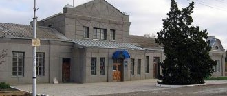
Mill in the city of Krasny Kut
In 1925, the city acquired the status of a rural settlement, although earlier in the first years after the revolution it was given the status of a city.
Geography and transport
Monument to the fallen in the Great Patriotic War
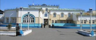
The city is located in the Trans-Volga region, on the right bank of the Eruslan River (a tributary of the Volga), 117 km southeast of Saratov. The city has a junction railway station of the Volga Railway, a line to the Urbakh station goes to the north, a line to Astrakhan goes to the south, and a line to Alexandrov Gai goes to the southeast.
In the city under KLUGA there is an airport of local airlines, but despite the existing status, neither passenger nor cargo transportation is carried out, the airfield is used only for training purposes.
Industry
Mill building
The city has factories: a reinforcement factory, an electromechanical factory, a dairy factory, a food processing plant, a sorghum seed processing plant, an elevator, and a poultry plant. Several mobile mechanized columns (PMCs) are based in the city. as of 1952, there was also a butter and cheese factory and a brick factory (operating until the 1990s). The Krasny Kut breeding station is located in the Krasnokutsky district.
Among the railway transport enterprises in the city there are: a replacement point for locomotives from the Ershov locomotive depot (previously there was an independent locomotive depot), Krasnokutsk track distance (RF).
Timezone
The city of Krasny Kut, like the entire Saratov region, is located in a time zone designated by the international standard as Moscow Time Zone (MSK). The offset relative to UTC is +4:00 (Moscow time).
Red Kut
origin of name
In the Saratov region, in a picturesque place, on the banks of a small river called Eruslan (translated from Turkic as “leopard, lion”), a left tributary of the Volga, lies a small town with the sonorous name Red Kut. There are several versions of the origin of the city's name.
The most beautiful version is connected with the story that when the first settlers came to these places, they saw in front of them a steppe completely covered with red tulips. Hence the name. The most plausible option involves a connection between the name of the historical homeland of the first settlers (Krasnokutsk, Kharkov province) and the name Krasny Kut. Well, as is customary to this day, the new village was given the old name - Red Kut. In Ukrainian, “red” means beautiful, and “kut” means a place or corner. And what was meant - a beautiful place or a corner - one can only guess.
City in the 19th century
Current historical data tells us that the first inhabitants appeared in these places at the beginning of the 19th century, namely in the summer of 1813. The settlers were people invited by the then governor, A.D. Panchulidzev, to work on transporting salt from the famous Lake Elton. This is the largest mineral lake in Europe and one of the most mineralized in the world. The first settlers were not from peasants, but from “military inhabitants” - Cossacks registered in the regiments and who had already served their term.
The bulk of the migrants were natives of three Ukrainian settlements in the Kharkov province - Krasnokutsk, Murafa and Pavlovka. The year 1819 is considered the official founding date of the village; at the same time, the main streets of the city received their names. Of course, the names were given in honor of their native places - Murafa and Pavlovka.
The salt had to be delivered to Pokrovskaya Sloboda, which is now the city of Engels. Due to the expansion of salt mining in 1837, a new wave of settlers arrived here. Therefore, some sources consider this year to be the founding date of Red Kut.
A military road passed through these places, connecting the arid Caspian steppes with the famous Nikolaevsky tract. This was an additional factor for the development and enrichment of the village; Yamsk stations and the first inns appeared. According to existing statistics, by 1859 in the village of Krasny Kut there were 179 households and more than 1,500 residents, there was an Orthodox Church, the Church of St. Michael the Archangel. In the center of the village there was a large pond. Subsequently, a market square was formed next to it. Over time, salt production on Lake Elton began to decline, and in the 1880s. and was completely stopped. The main source of income for residents in that period was purely agricultural labor associated with cultivating land and raising livestock. A turning point in the history of the village of Krasny Kut was the appearance of the railway.
In a matter of years, the railway artery changed the hitherto modest village beyond recognition. With the advent of the road, a very significant economic facility opened in Krasny Kut - a large food market, which worked mainly on Saturdays. Almost fifty surrounding villages brought the results of their labor to the market for sale. Various kinds of institutions opened, a railway depot, and the number of residents grew rapidly. In fact, it was during this period that Krasny Kut began active progress towards the status of a city, although it would be officially received only back in 1966. This event will be preceded by a host of other important historical events that Krasny Kut will experience together with the great and vast country.
During the period of revolutions and civil war
The year is 1905. The first “Russian revolution”, the echoes of which swept throughout Russia. Red Kut did not stand aside. On May 1, 1905, a column of 300 workers from the local railway depot, led by revolutionary movement activist P. A. Pruzhnikov (Pluzhnikov), headed towards the center of the village. The procession was accompanied by revolutionary songs, and as a result the performance was suppressed by the local police. At the same time, several people were injured, and the revolutionary leader was sentenced to hanging. The sentence was carried out a year later in a Saratov prison.
In 1910, according to the census, almost 3,300 people lived in 769 households in Krasny Kut. National composition of the population: Russians, Ukrainians and Germans. The village became the center for the Krasnokutsk volost, which was part of the Novouzensky district of the Samara province. The area of the district was larger than the Moscow province; it was the size of Holland. By this time, the village had all the necessary attributes of a small town, namely a volost government, its own hospital, a school, several churches, a post office, a brick factory, a steam and windmills, a grain exchange, a military horse station, and a pier for rafting timber. In Krasny Kut, a constable and a police officer regularly performed public service, a doctor and a paramedic worked. There was also a veterinarian in the village.
The year is 1917. Soviet power comes to Krasny Kut, the volost Council of Workers' and Peasants' Deputies is created. The backbone of the new governing body consists of the most politically active people: soldiers demobilized from the fronts of the First World War, as well as activists from local railway workers who showed themselves during the Russian Revolution of 1905. On January 24, 1918, the transfer of all full power to the local Council of Workers' and Soldiers' Deputies. For the needs of the Council, the house of the merchant Dumler was nationalized, in which the first meetings were held, and subsequently the district executive committee was located there. In May 1918, the Krasnokutsk Bolshevik organization was created.
The civil war swept through the whole of long-suffering Russia in a bloody wave, and it did not bypass Krasny Kut. In the vicinity of the city, the so-called green gangs operated, which were detachments of irregular, mainly peasant and Cossack armed units. This freemen resisted both the Bolsheviks and the White Guards and foreign interventionists. In those days, the concepts of “red-green” (more gravitating towards red) and “white-green” (more gravitating towards white) existed in everyday life, and many (anarchists) even opposed everyone.
The civil war died down. In 1922, within the framework of the Autonomous Republic of Volga Germans, the Krasnokutsk canton was formed, which united 47 local village councils. An agricultural technical school opened its doors, and the first collective farms appeared in the early thirties. In 1938, the village of Krasny Kut was given the status of a working village.
During the Great Patriotic War
The Great Patriotic War began. Thousands of Krasnokutsk residents went to the front, more than three thousand people did not return to their homes, dying on the battlefields. The famous Kachin flight school was evacuated to the village and operated until May 1947. Among its graduates are air marshals, more than 170 generals, almost 300 heroes of the Soviet Union, including 12 pilots - twice heroes and the legendary Soviet ace, three times Hero of the Soviet Union - A. Pokryshkin. During the war, evacuation hospitals operated in the village.
Post-war period and modern times
After the end of the Great Patriotic War, the village began to actively develop, a number of enterprises appeared, new secondary and vocational schools and vocational educational institutions opened. According to data for 1959, the population of Krasny Kut is already almost 15 thousand people. The growth of infrastructure and population led to the fact that in 1966 the village received city status.
On the morning of August 6, 1961, Krasny Kut became a participant in a significant event and was featured in news reports of all the major news agencies in the world. It was near Krasny Kut that German Titov, who made the second space flight in human history, landed by parachute. Subsequently, the legendary cosmonaut visited this place on earth that had become his home more than once.
In the 1960s–1980s. the city has changed a lot. Storied residential buildings of typical urban development appeared. The agricultural technical school changed its profile and became a veterinary school. A hotel and a new post office building were built, and new medical buildings appeared in the local hospital. The population of the city of Krasny Kut by 1989 reached 17 and a half thousand people.
In 1998, the city of Krasny Kut got its own coat of arms: on a green field - two crossed ears of corn and a tulip on top of them. Today this settlement is a quiet and small town, but its history, like a mirror, reflects the history of a great great country. History is, first of all, people. Natives of Krasny Kut are widely known in the USSR: S. I. Kharlamov (Hero of the Soviet Union); A.K. Puzach (football coach); V. M. Livshits (literary critic and publicist); Yu. A. Zimina (TV presenter).
Attractions
Monument at the landing site of the Vostok-2 spacecraft
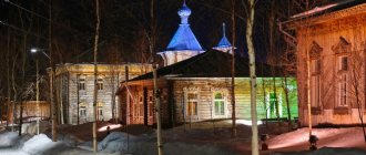
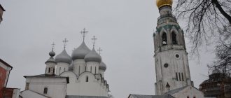
There is a Holy Trinity Church in the city.
On August 7, 1961, the descent module of the Vostok-2 spacecraft, piloted by cosmonaut G.S. Titov, landed near Krasny Kut. An obelisk was installed at the landing site.
Population of the city of Krasny Kut, Saratov region
In 1859, according to the Central Statistical Committee and the list of populated places of the Russian Empire, there were about 1,415 inhabitants in Krasny Kut.
Over 80 years, the population grew by 11,300 people (in 1939 - 12,716 people) of which 56% were Russians, 22% Ukrainians, 14% Germans and others.
During the collapse of the Soviet Union 1989-1992, the city experienced a population decline of 200 people (in 1989 - 17,384 people, in 1992 - 17,100 people), and since 1992 the population has been steadily declining.
Between 1996 and 2021 the population decreased by 2,800 people. As of 2021, the population of the city of Krasny Kut is 14,483 people.