Year founded: 1150
The date of the city day is unique for each year.
In 2021,
this date is
August 28
.
In 2021, due to the pandemic, mass events in honor of the city day are canceled or may be postponed
Railway station and water tower in Yelnya (Photo: wikipedia.org)
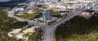
Yelnya
- Russian city, administrative center of the Elninsky district of the Smolensk region. Located 82 km from Smolensk, in the upper reaches of the Desna River (a tributary of the Dnieper).
The city got its name from the Old Russian word “elina”, which means “fir”. It was first mentioned in 1150
. The chronicles say that the Kiev prince Svyatoslav Olegovich decided to build the Elna fortress to protect the Smolensk principality from the east: he was tired of the constant raids of appanage princes. Since then, the fortress began to be populated by people and turned into an independent city.
In the Middle Ages, Yelna had a hard time. In the 13th century it was ravaged and burned by the Tatar-Mongols, and two centuries later it came under the rule of Lithuania. The city had to prove its independence for a long time, until 1667, when it finally became part of the Russian state.
By the end of the 18th century, a forge, a tavern, an almshouse and a drinking house appeared in Yelnya, the city began to develop and grow, but war came. In 1812, Napoleonic troops invaded Yelnya. Partisans operated here under the command of Davydov, Seslavin, Figner; They defeated the brigade of the French General Augereau. M.I.’s headquarters was also located in Yelnya. Kutuzov, from where he gave the historical order to complete the defeat of the enemy and actively pursue him.
Mass grave in the city square (Photo: wikipedia.org) But the city suffered most of all during the Great Patriotic War. Fascist troops occupied Yelnya in July 1941, fierce battles under the leadership of Marshal Zhukov lasted 50 days. In September the city was liberated, but not for long. A month later, Yelnya was occupied for the second time, and its final liberation took place in August 1943. By this time, out of more than 7 thousand inhabitants on the Elninsky land, only 700 remained.
But it was necessary not only to fight, but also to restore the economy. By June 1945, the Elninsky brick factory was rebuilt here, and it began to produce 2 times more products. Another year and a half later, the city power plant was restored. In the post-war years, a music school was opened in Yelnya, a knitting factory began operating, and by the end of the 1980s, more than 10 thousand residents lived in Yelnya.
In 2007, by presidential decree, the city of Yelnya was awarded the honorary title of the Russian Federation “City of Military Glory”.
Today in Yelnya there are a knitting factory and a bakery, a wagon factory, a brick factory and a cheese-making factory. Agriculture is also developed - flax, rye, oats, barley and potatoes are grown here. Cattle are raised.
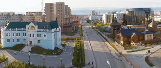
Elias Church (Photo: wikipedia.org)
In Yelnya there is a military fraternal cemetery where the ashes of more than 20 thousand fallen soldiers rest. It is located in the Square of Military Glory, which was founded after the war. The memorial complex also includes: an obelisk to the first guards, an alley of commanders, a chapel in memory of unknown soldiers and a monument to internationalist soldiers. Next to the square is the St. Elias Church, destroyed during the Great Patriotic War and restored in 1992. The railway station is an architectural monument of the 19th century.
Not far from Yelnya, 20 kilometers away, is the village of Novospasskoye - the birthplace of Mikhail Ivanovich Glinka. Here is the House-Museum of the great Russian composer, which contains about 300 exhibits - personal belongings of Mikhail Ivanovich. In the Elninsky district, in the village of Bezzaboty, the writer A.A. was born. Shakhovskaya. And in the village of Glotovka, the Soviet poet V.M. was born into the family of a poor peasant. Isakovsky.
This land is also rich in other talents. Soviet leaders Veniamin Rukosuev and Joseph Makovsky, Hero of the Soviet Union, were born here. The famous Soviet sculptor Sergei Konenkov, the author of many portraits of Russian writers, was born in Elninsky district. The sculpture museum named after him is located in Smolensk.
Day of the city
in Yelnya it is celebrated in August.
History of conferring the honorary title “City of Military Glory”
The bright pages of Yelnya's history are connected with the Great Patriotic War of 1941-1945.
The military history of the initial period of the war notes the special significance of the Yelninsky operation. The offensive operation of the troops of the 24th Army of the Reserve Front was carried out on August 30 - September 8 during the Battle of Smolensk 1941 with the aim of eliminating the so-called Elninsky ledge. The Yelnya ledge was formed in mid-July as a result of the breakthrough of the enemy’s 2nd Tank Group south of Smolensk and the capture of Yelnya on July 19. The fascist German command planned to use this ledge as an advantageous springboard for resuming the offensive against Moscow. As a result, the troops of the 24th Army defeated two tank, one motorized rifle and 7 infantry divisions of the enemy, eliminated the Elninsky ledge, which threatened the left wing of the troops of the Western Front, and liberated a significant territory. During the war, over 8 thousand Yelnin residents died. In the center of the city, in the park, there is a military brotherly cemetery, where the ashes of more than 20 thousand fallen soldiers rest.
On October 8, 2007, by decree No. 1346 of the President of the Russian Federation, the city of Yelnya “For the courage, fortitude and mass heroism shown by the city’s defenders in the struggle for the freedom and independence of the Fatherland” was awarded the honorary title of the Russian Federation “City of Military Glory.”
Population
| Population | ||||||
| 1856[5] | 1897[5] | 1913[5] | 1926[5] | 1931[5] | 1939[6] | 1959[7] |
| 3700 | ↘2400 | ↗7500 | ↘4400 | ↘4300 | ↗7132 | ↘6897 |
| 1970[8] | 1979[9] | 1989[10] | 1992[5] | 1996[5] | 1998[5] | 2000[5] |
| ↗8336 | ↗9078 | ↗9868 | ↘9500 | ↗10 700 | ↗11 600 | ↘10 900 |
| 2001[5] | 2002[11] | 2003[5] | 2005[5] | 2006[5] | 2007[5] | 2008[12] |
| ↘10 700 | ↗10 798 | ↗10 800 | ↘10 300 | ↘10 200 | ↘10 000 | ↗10 100 |
| 2009[13] | 2010[5] | 2011[5] | 2012[14] | 2013[15] | 2014[16] | 2015[17] |
| ↘9991 | ↘9900 | ↗10 100 | ↘10 025 | ↘9783 | ↘9573 | ↘9463 |
| 2016[2] | ||||||
| ↘9324 | ||||||
Perpetuating memory (Main monuments related to the Second World War)
- A memorial stone and monument in the central square, erected in honor of the 4 rifle divisions that participated in the Yelninsk operation.
- The Chapel of Memory is a memorial, a monument at the sites of mass graves of the Second World War.
- Tank "T-34", installed to commemorate the victory of the Soviet people in the Great Patriotic War of 1941-1945.
- The grave of partisan L.M. Kapitonov, who died in the fight against the Nazis.
- The place where fierce battles took place between Soviet troops and partisans of the regiments named after. S. Lazo and them. 24th anniversary of the Red Army with fascist invaders
- Mass grave of Soviet citizens executed by the Nazis.
- Sculptural composition to the First Guards - 100, 127, 153, 161 rifle divisions, who distinguished themselves in battles against the fascist invaders in 1941.
- Obelisk to the soldiers of the 6th Guards Division who fell in battles with the fascist invaders in 1941-1942.
- Monument to militia soldiers of the 9th Kirov Division of Moscow who accomplished feats in battles with the Nazis in 1941.
- Obelisk in honor of the partisan teacher L.I. Lyzlova, who died behind enemy lines in 1942.
- Stele "City of Military Glory".
Population[ | ]
| Population | ||||||||
| 1856[5] | 1897[5] | 1913[5] | 1926[5] | 1931[5] | 1939[6] | 1959[7] | 1970[8] | 1979[9] |
| 3700 | ↘2400 | ↗7500 | ↘4400 | ↘4300 | ↗7132 | ↘6897 | ↗8336 | ↗9078 |
| 1989[10] | 1992[5] | 1996[5] | 1998[5] | 2000[5] | 2001[5] | 2002[11] | 2003[5] | 2005[5] |
| ↗9868 | ↘9500 | ↗10 700 | ↗11 600 | ↘10 900 | ↘10 700 | ↗10 798 | ↗10 800 | ↘10 300 |
| 2006[5] | 2007[5] | 2008[12] | 2009[13] | 2010[5] | 2011[5] | 2012[14] | 2013[15] | 2014[16] |
| ↘10 200 | ↘10 000 | ↗10 100 | ↘9991 | ↘9900 | ↗10 100 | ↘10 025 | ↘9783 | ↘9573 |
| 2015[17] | 2016[18] | 2017[19] | 2018[2] | |||||
| ↘9463 | ↘9324 | ↘9168 | ↘8993 | |||||
As of January 1, 2021, in terms of population, the city was in 966th place out of 1115[20]cities of the Russian Federation[21].
Merits of the city in the military history of Russia
Yelnya is one of the oldest settlements in the Smolensk region. For a long time it was under the rule of foreign invaders and only in 1667, according to the Truce of Andrusovo, it finally entered Russia. In 1776, Yelnya became a city and a district center of the Smolensk governorship, then a provincial city, and in 1802 again a district center.
In 1812, Yelnya was one of the first Russian cities to be invaded by the troops of the French Emperor Napoleon. Residents of the county took an active part in the fight against foreign invaders. They donated a million rubles to defeat the enemy. Partisans operated on Elninsk land under the command of Davydov, Seslavin, and Figner.
Here the brigade of the French general Oger was surrounded and, after a fierce battle, completely destroyed.
The headquarters of M.I. was located in Yelnya. Kutuzov during the offensive of the Russian army.
The bright pages of Yelnya's history are connected with the Great Patriotic War of 1941-1945. In the second half of July 1941, under the pressure of many times superior enemy forces, the city was abandoned by our troops, who entrenched themselves 18 kilometers east of it. The enemy's attempts to develop an offensive were defeated by the steadfastness and courage of the formations of the 24th Army, and he was forced to go on the defensive. The so-called Yelninsky ledge was formed, which ran deep into our defenses, creating a threat to the flags and rear of the Soviet troops in the Vyazma direction. In order to eliminate this protrusion, units of the Soviet Army launched an offensive on August 30, 1941, by order of the High Command.
As a result of bloody multi-day battles, the enemy's Yelnya group was defeated and on the morning of September 6 a red flag hoisted over Yelnya. In these battles, soldiers showed miracles of bravery, bravery and heroism. Fourteen of them were awarded the high title of Hero of the Soviet Union.
For two years Yelnya was under Nazi occupation. On August 30, 1943, tank crews of the 2nd Guards Corps and soldiers of units of the 10th Guards Army captured the city. The most distinguished two rifle divisions, three tank brigades and a separate regiment were given the name “Yelninsky”.
Tradition of lyrical songs of the city of Elnya, Elninsky district, Smolensk region
The city of Yelnya is one of the oldest settlements in the Smolensk region; its first mention dates back to 1150. Since 1776, Yelnya has been a district town of the Smolensk governorship. Currently, Yelnya is not only a historical site, but also one of the brightest centers of traditional folk musical culture.
The custodians of the Elninsky song tradition are members of a wonderful authentic folklore ensemble consisting of local residents of the older generation - seven women aged 62 to 85 years and one man, Nikolai Pavlovich Sinyukhin, born in 1930. His participation in the group is of particular interest, since until now folklore collectors have rightly noted the predominantly female character of the Smolensk song tradition, including the lyrical one. It should be noted that N.P. Sinyukhin is by no means a leader in the ensemble; it is difficult for him to show his performing initiative in the self-sufficient female sound world of local musical and poetic folklore. In lyrical songs, he duplicates the line of the upper voice an octave lower.
Most often, lyrical songs were sung in the open air: in a field, in a meadow, on the street. They could also be sung on the go, for example, on the way to haymaking. At the same time, the vocal style was distinguished by extreme volume: they sang at the top of their lungs, loudly. In this way, a timbre was “developed”, designed to sound in a wide space.
Such qualities of the sound world of the female folklore tradition as collective singing in nature, extremely loud sound, “formular” syllabic rhythm, and the relative limited “vocabulary” of melodic turns form easily recognizable features of the traditional Smolensk lyrical song. The stylistic unity of women's lyrical songs is convincingly manifested by the Yelninsky singers using classic, simple and wise song material for the local folklore tradition.
The local style is dominated by the principle of repetition. The similarity of works with different texts is revealed primarily in the narrowness of the scales, which, as a rule, do not exceed fifths. A small part of the songs, for example, “Dove Dove” and “Totally My Tummy,” are of a quart nature, which makes them similar to local ritual songs. The tunes of most lyrical songs have a volume of fifths: “By the well, by the deep one,” “There was a white birch tree on the mountain,” “We have three thorn paths in the field,” “My black eyebrows,” “I’m tired of it,” and “The evening dawn has set.” " During the sound recording, which took place indoors, all songs were sounded in a relatively low register - from B-flat of the small octave to G of the first octave. Singing at such a height sounded soft, easy and not extremely loud. But it seems that in an open space, in nature, an increase in volume would also lead to an increase in the singing register by about a third.
Unison polyphony with elements of heterophony mainly in the final sections of the tunes, a limited number of melodic turns, very similar to each other, the absence of wide intra-syllable chants, the connection of each tune with not one, but with a whole group of poetic texts - these are the main features of Yelninsky lyrical songs that form the basis , the “core” of the local vocal repertoire.
Against this background, songs with a wide sound volume look isolated: “The conversation was intoxicating,” “My birch splinter,” “A wild berry was born.” All of them differ significantly from the main group of local lyrical songs and have not so much a local, Elninsky, but an all-Russian character, characteristic of many local traditions.
The song “A wild berry was born” in its melodic structure is clearly “alien” for the Yelnya tradition. But it is more suitable than others for solo and duet performance. In the solo singing of Nikolai Pavlovich Sinyukhin one can note a soft male vibrato, a style close to academic singing. And in his joint performance of the same song with the wonderful 85-year-old singer of the group, Maria Efremovna Kosenkova, parallel sixths are beautifully and purely intonated in an “inverted” two-voice, where the line of the upper voice is led by a man in a lower register, and the “second” sounds at the top of the woman.
All the group’s chants are characterized by skillful intonation variation, “playing” with timbre and modal colors, the ability to build a composition of large-scale multi-stanza songs and gently highlight the climax of the chant, which, as a rule, coincides with the point of the “golden ratio” within the stanza.
Noteworthy are also such features of the local singing tradition as an even greater prolongation of the long upper sounds in the initial phrases of the chant (“There was a white birch tree on the mountain”, “By the deep well”, “Dove dove”, “My black eyebrows”, “ I want to grow my belly"), free transitions to recitative fragmentation, performance almost “talking” in the middle sections of the chants, and then again to a smooth leading of the melody in the final phrases.
Currently, Elninsky lyrical songs are of great interest to many youth amateur folk ensembles, who actively include them in their repertoire.
Merits of the city's rear
At the beginning of October 1941, units of the Red Army were forced to retreat, and the city and region were temporarily occupied by the Nazi invaders. Elnin residents, like thousands of Smolensk residents, began a partisan fight against the enemy.
In February 1942, 2 partisan regiments were created on the basis of partisan groups and detachments. In the southern part of the region there was a regiment named after S. Lazo (regiment commander Vasily Vasilyevich Kazubsky - director of the Korobetskaya secondary school, regiment commissar - Andrei Fedorovich Yudenkov). In the northeastern part of the region, a partisan regiment named after the 24th anniversary of the Red Army operated (the regiment commander was Fedor Danilovich Gnezdilov, the commissar was Gayan Sufiyanovich Amirov). By the spring of 1942, the regiments numbered over 4,700 soldiers and commanders.
On March 23-24, 1942, detachments of partisan regiments fought for Yelnya and liberated almost the entire city from the enemy. The partisans recaptured the territories of 25 rural Soviets (out of 31) from the Nazis and, by decision of the underground Elninsky district executive committee of March 20, 1942, restored Soviet power there.
The partisan detachments operated in difficult conditions, close to the front, where the Nazis created a deeply echeloned defense, concentrating over 40 divisions. During the occupation, Elninsky partisans destroyed over 7 thousand fascists, 12 headquarters, and a large number of military equipment. They helped carry out the combat mission of Belov's 1st Guards Corps and General Kazankin's 4th Airborne Corps.
The partisan movement was a vivid manifestation of the initiative of the masses, strengthened confidence in victory over the Nazi invaders, and brought Victory Day closer.
2 years of fascist occupation have passed. On August 7, 1943, troops of the Western and Kalinin Fronts began their offensive. During Operation Suvorov, the Elninsky and Dorogobuzhsky districts were liberated.
Geographical location[ | ]
The city is located in the southeastern part of the Smolensk region and occupies a watershed plateau - part of the so-called “Elninsky Knot” of the Smolensk-Moscow Upland. The rivers that originate here flow in different directions. Uzha (the left tributary of the Dnieper itself), originates northwest of Yelnya and flows in a northerly direction. The Desna (the largest left tributary of the Dnieper) originates northwest of Yelnya and carries its waters in a southerly direction. The Stryana River, a right tributary of the Desna, also flows from north to south. The Ugra River (the Oka River basin) originates in the southeastern corner of the district, flows through its territory in a northern direction, and then near the village of Sledneva it turns sharply to the east and goes into the Vskhodsky district. The Usiya (left tributary) and Demina (right) flow into the Ugra River in the Elninsky region. In the west, near the border of the Elninsky and Pochinkovsky districts, the basin of the Khmara River (a tributary of the Sozh) begins.
Brief description of the area
The Smolensk region occupies about 50,000 km in the center of the East European Plain. There are both highlands and lowlands here. The climate here is moderate continental, as the climate zone is temperate. Driving through this area, you can observe wavy surfaces, hilly areas, and river valleys.
On the territory of the Smolensk region there are many minerals of sedimentary origin. Here you can encounter deposits of brown coal, peat, rock salt, loam, and clay. Nature has not deprived these lands of healing mud and mineral waters. Sometimes there are deposits of rock crystal, silicon, ore, and ocher. Peat reserves in this area are very large. Sand, gravel, and gypsum are mined here for construction work.
In winter the temperature here is moderately frosty, in summer it is warm and rainy. Such tributaries of the Dnieper as the Vyazma, Vop, Desna, and Sozh flow through the region. From here such large rivers as the Volga and Oka, into which the Vazuza and Ugra flow, also replenish their water reserves.
The main area of the Smolensk region is occupied by sod-podzolic soils. Sometimes there are sandy and loamy areas. There are many forests, meadows, and swamps in this region. Cultivated plants are widely planted. The main representatives of forests are spruce, birch, and aspen. Oaks, maples, ash trees, and linden trees are slightly less represented. The fauna here is represented by many species of mammals and birds. About 50 species of fish are found in local reservoirs.
References
Notes
- ^ abcdefghi Resolution No. 261
- ^ a b c Historical information (in Russian). Administration of Elninsky district. Retrieved June 5, 2021.
- ^ a b Federal State Statistics Service (2011). All-Russian Population Census 2010. Volume 1 [All-Russian Population Census 2010, vol. 1]. All-Russian Population Census 2010 [All-Russian Population Census 2010] (in Russian). Federal State Statistics Service.
- "26. The size of the permanent population of the Russian Federation by municipalities as of January 1, 2021". Federal State Statistics Service. Retrieved January 23, 2021.
- ^ abcd Law No. 108-z
- Federal State Statistics Service. Federal Agency for Technological Regulation and Metrology. No. OK 033-2013 January 1, 2014 “All-Russian classifier of municipal territories. Code 66 619 101 ". (Federal State Statistics Service. Federal Agency for Technological Regulation and Metrology. No. OK 033-2013 January 1, 2014. Russian classification of municipal territories. Code 66 619 101.
). - "On the Calculation of Time". Official Internet portal of legal information
. June 3, 2011. Retrieved January 19, 2021. - Post office. Information and computing center of OASU RPO. ( Post office
).
Search for postal service objects ( postal Search for objects
) (in Russian) - ↑
Federal State Statistics Service of Russia (May 21, 2004). Population of the Russian Federation as part of federal districts. [Population of Russia, its federal districts, constituent entities of the Federation, districts, urban settlements, rural settlements - administrative centers and rural settlements with a population population more than 3000 people] (XLS). All-Russian Population Census of 2002 [All-Russian Population Census of 2002] (in Russian). - All-Union Population Census of 1989 Population of Union and Autonomous Republics, Autonomous Regions and Districts, Territories, Regions, Urban Settlements and Village District Centers [All-Union Population Census of 1989: Current Population of Union and Autonomous Republics, Autonomous Regions and Districts, Territories, Regions , districts, urban settlements and villages performing the functions of district administrative centers]. All-Union Population Census of 1989 [All-Union Population Census of 1989] (in Russian). Institute of Demography of the National Research University: Higher School of Economics [Institute of Demography of the National Research University: Higher School of Economics]. 1989 - via Demoscope Weekly
. - Moskalev, O.L. History of the education system (in Russian). Museum of the History of Education of the Smolensk Region. Retrieved May 22, 2021.
- Boris Parfenov; Olga Khorenzhenkova. On the history of the formation of the Smolensk region (in Russian). Smolensk. Retrieved May 21, 2018.
- https://www.yahadmap.org/#village/yelnya-smolensk-russia.547
- Enterprises and organizations (in Russian). Administration of Elninsky district. Retrieved June 1, 2021.
- Tourism (in Russian). Administration of Elninsky district. Retrieved June 5, 2021.
Sources
- Administration of the Smolensk region. Resolution No. 261 of April 30, 2008 “On approval of the registration of administrative-territorial units and territorial units of the Smolensk region,” as amended. Resolution No. 464 of June 27, 2014 “On amendments to the register of administrative-territorial units and territorial units of the Smolensk region.” Published: Database “Consultant-plus”. (Administration of the Smolensk region. Resolution No. 261 of April 30, 2008 “ On approval of the Register of administrative-territorial units and territorial units of the Smolensk region”
as amended by Resolution of June 27, 2014 No. 464 “
On amendments to the Register of administrative-territorial units of the Smolensk region"). Administrative-territorial units and territorial units of the Smolensk region
). - Smolensk Regional Duma. Law No. 108-z of December 20, 2004 “On granting the status of a municipal district to the municipal formation” Elninsky district “of the Smolensk region, on establishing the boundaries of municipalities whose territories are part of it, and granting them the appropriate status,” as amended. Law No. 108-z of November 23, 2011 “On Amendments to the Regional Law” On granting the status of a municipal district to the municipal formation “Elninsky District” of the Smolensk Region, on approving the boundaries of municipalities whose territories are part of it, and granting them the appropriate status "". Came into force on the date of official publication. Published: “Bulletin of the Smolensk Regional Duma and Administration of the Smolensk Region”, No. 13, part II, p. 144, December 22, 2004 (Smolensk Regional Duma. Law of December 20, 2004 No. 108-z “On assignment to a municipal entity” Elninsky district "of the Smolensk region the status of a municipal district, on establishing the boundaries of municipalities on the territory of which it is located "On assigning them the appropriate status"
as amended by the Law of November 23, 2011 No. 108-z "
On amendments to the regional law" On assigning the status of a municipal district to the municipal formation "Elninsky district" of the Smolensk region "dated
November 23, 2011.
Establishing the boundaries of municipal formations, the territories of which they are included, and assigning them the appropriate status
." Valid from the date of official publication.).
Urban settlement[ | ]
Elninskoye urban settlement (total area 86 km², population 10,605 people): formed on December 1, 2004, located in the central part of the region. In addition to the city, Yelnya includes the villages: Vasilki, Danino, Moitevo, Podgornoye, Prilepy, Romashkovo, Khodykino, Kholmy, Shuyarovo, Yaroslavl.
in the west - with the Leonidovsky rural settlement
The head of the municipality and chairman of the council of deputies is Vladimir Evgenievich Levchenkov, the head of the administration is Nikolay Danilovich Mishchenkov[22].
Polish tanks 46 km from Brest. Is Warsaw preparing an attack on Belarus?
Following the Americans, the Ukrainian media, as well as a number of Russian publications recognized as foreign agents, took up the topic. And there, of course, they also don’t ask the question: are the troops deployed too far away?
Who could really be offended is Poland. Warsaw politicians talk in every possible way about the “Russian threat,” but no one even suggested that Russian tanks near Yelnya are preparing to attack Poland. But Yelnya is less than 700 kilometers from the Polish border - even closer than Donbass.
By the way, currently the Polish camp with about 350 military equipment, including Leopard tanks, is located just 46 km from the Belarusian Brest. Moreover, this fact was officially confirmed by the Polish Ministry of Defense.
However, for some reason neither Politico nor other foreign publications see in such a deployment of forces preparation for an armed invasion of the Republic of Belarus. Apparently because “it’s different.”
Sights of the Smolensk region
Sights of the Smolensk region. The most important and interesting sights of the Smolensk region - photos and videos, descriptions and reviews, location, websites.
- Last minute tours
to Russia
- Smolensk region the very best
Katyn forest
15 kilometers from Smolensk is the world-famous Katyn Forest. The picturesque forest area on the banks of the Dnieper, between the villages of Katyn and Gnezdovo, unfortunately, has a very tragic history.
Smolensk region, Talashkino village
Talashkino
Smolensk region, Talashkino village
The Tenishev princes acquired the Talashkino estate in 1893. The estate owes its fame to its owner, Maria Klavdievna Tenisheva, an educator and philanthropist who spared no time and effort in creating an exemplary farm, a school for peasant children and applied arts workshops.
Smolensk region, Vyazemsky district
Khmelita
Smolensk region, Vyazemsky district
There is a wonderful place in the Smolensk region that will appeal not only to lovers of original Russian landscapes and quiet provinces, but also to fans of Griboedov’s work. We are talking about the historical, cultural and natural reserve Khmelita.
Vyazma, st. Lenina, 11
Arkadievsky Monastery
Vyazma, st. Lenina, 11 The Arkadievsky Monastery, known throughout the Smolensk region for its women's choir, skilled needlewomen and zealous prayer books, has not survived intact to this day. By the end of the 20th century. it has almost half lost its original appearance, retaining only a small fraction of its former splendor.
Vyazma, st. Vosstaniya, 8
Exhibition hall of the Vyazemsky Museum of Local Lore
Vyazma, st. Vosstaniya, 8 In 1992, an exhibition hall was opened at the Vyazemsky Museum of History and Local Lore, designed to host a variety of temporary exhibitions: artistic, historical, everyday, ethnographic, local history and many others. The museum is located in an ancient building built at the beginning of the 20th century.
Vyazma, st. Dokuchaeva, 48A
Vyazemsky St. John the Baptist Monastery
Vyazma, st. Dokuchaeva, 48A Vyazemsky St. John the Baptist Monastery is located in a surprisingly clean, very cozy, almost idyllic place. A kind of peaceful silence reigns everywhere; here it is so easy to drive away obsessive thoughts about everyday worries and be alone with yourself.
Vyazma, pl. Sovetskaya, 3
Vyazemsky Museum of History and Local Lore
Vyazma, pl. Sovetskaya, 3 The Vyazemsky Museum of History and Local Lore is visited not only by tourists who are interested in the historical past of the city; every self-respecting traveler strives to pay attention to this museum, and there are several undeniable reasons for this.
Gnezdovo mounds
Smolensk region, village. Gnezdovo Not far from Smolensk, only 12 kilometers, is the archaeological reserve Gnezdovo Kurgans. The complex consists of burial mounds and ancient settlements. The historical and cultural monument owes its name to the village of Gnezdovo, located on the banks of the Dnieper.
Vyazma, pl. Efremova, 3, apt. 22
Museum of Sergei Yesenin in Vyazma
Vyazma, pl. Efremova, 3, apt. 22 The Vyazemsky Museum of Sergei Yesenin is the first and to date the only museum in the Smolensk region dedicated to the life and work of the famous poet. Not only is it not inferior in value to its collection to the Yesenin Museum in the village of Konstantinovo, it is also a very homely, warm museum.
Vyazma, per. Nagorny, 1
Holy Trinity Cathedral in Vyazma
Vyazma, per. Nagorny, 1 In the historical center of Vyazma, on the left bank of the river, is located the beautiful Holy Trinity Cathedral - the heart of the city and a place of attraction for numerous pilgrims and ordinary tourists wandering across the vast Russian expanses.
Smolensk region, Demidovsky district, pos. Przhevalskoe, st. Gurevicha, 19
Smolensk Poozerie
Smolensk region, Demidovsky district, pos. Przhevalskoe, st. Gurevicha, 19 It’s not hard to guess why the Smolensk Poozerie National Park is called that way. Of course, it is located near Smolensk and surrounded by a large number of reservoirs. There are as many as 35 lakes of glacial origin, each of which is beautiful in its own way.
Vyazma, st. Dokuchaeva, 48A
Church of Hodegetria in Vyazma
Vyazma, st. Dokuchaeva, 48A A flower of amazing beauty bloomed in the 17th century on Vyazma land and still adorns these lands - the Odigitrievskaya Church, the like of which is no longer found not only in Vyazma, but throughout the entire Smolensk region. The temple is also characterized by the fact that it is included in the UNESCO World Heritage List.
Smolensk is rich in historical architectural attractions, the bulk of which are temples, cathedrals and monasteries. These include: the Church of Michael the Archangel, built at the beginning of the 12th century, the Avraamiev Monastery, founded at the beginning of the 13th century, the Smolensk fortress wall erected at the end of the 16th century, the Smolensk forge - the oldest civil building in the Smolensk region (built at the turn of the 17th-18th centuries) , Church of the Immaculate Conception of the Blessed Virgin Mary (built from 1884 to 1896), etc. There are also about 30 monuments and memorials in the city, including the Scorched Flower, erected in memory of children who died in fascist concentration camps, the monument to the Defenders of Smolensk on August 4-5 1812, monument to Kutuzov. In the very center of the city, near the fortress wall, there is a Square in memory of heroes. There are only two such memorials in the Russian Federation: the second one is located on Red Square in Moscow.
In general, the Smolensk region is a western region of Russia, which can be called one of the most combative during the Second World War: many battles took place on its territory, as a result of which settlements passed from one hand to another.
The Katyn Forest is located just 15 kilometers from Smolensk. Unfortunately, this place is known for terrible events. On the site of the current Katyn Memorial, several thousand Polish and Soviet officers were shot in 1940. Now flowers and candles are brought to the memorial in memory of the fallen soldiers.
The Gnezdovo Kurgans archaeological reserve represents many burial mounds and settlements that have been preserved here since the times of Ancient Rus'.
The small village of Gnezdovo, located just 12 kilometers from Smolensk, invariably attracts the attention of tourists. The Gnezdovo Kurgans archaeological reserve is located here. It represents many burial mounds and settlements that have been preserved here since the times of Ancient Rus'.
Again, not far from the regional center there is another attraction - the Smolensk Poozerie National Park. It is formed by 35 lakes of glacial origin, each of which is unique in its beauty. The national park was created to preserve nature and study local flora and fauna. Many plants growing here are listed in the Red Book.
And in the Vyazemsky district of the Smolensk region there is the historical, cultural and natural reserve Khmelita, organized on the basis of the museum-estate of A. S. Griboyedov. This place is rightfully appreciated by both lovers of native Russian landscapes and admirers of the work of the great Russian writer Alexander Sergeevich Griboyedov.
In general, when talking about the sights of the Smolensk region, we must remember that the historical heritage of the Smolensk land, even if it does not always tell about joyful events, is an important part of the culture of our country.
Have you looked at the map?
It seems that this rich military history of Yelnya is what foreign experts have latched on to, talking about the “accumulation of troops” and linking this with actions towards Ukraine.
But here’s the thing: the Russian army has not yet mastered the art of teleporting manpower and equipment, and the base near Yelnya does not in any way contribute to the rapid conduct of operations against the Ukrainian Armed Forces. The distance from Yelnya to Donetsk is over 1000 kilometers along the highway, and about 800 in a straight line. From Yelnya to Lugansk is 1050 kilometers along the highway, and 790 in a straight line.
One can, of course, assume that the Russian army is going to strike immediately at the decision-making center, but it is also 500 kilometers from Yelnya to Kyiv, and this route goes through the territory of Belarus. The distance to the nearest point of the Ukrainian border from Yelnya is 250 km.
All this bears little resemblance to the deployment of units preparing for a strike. However, the authors of Politico do not bother themselves with deep analytics - it is enough to show the average person “pictures of tanks”, and he will figure out the rest himself. And if they say that Russia is on the threshold of Ukraine, then one cannot help but believe it.
The spear was broken. How the Pentagon “lost the war to Russia” Read more
Attractions[ | ]
On the left bank of the river. Desna, at the confluence of the Gorodianka River, on a low hill, the remains of a 12th century settlement have been preserved.
Since 1780, Yelnya developed according to a regular plan with a geometrically regular grid of streets lined with wooden houses. At the end of the 18th - beginning of the 20th centuries. stone buildings were built: a station complex, a water tower in pseudo-Gothic style, a gymnasium, shops; mainly in the right bank part of the city.
After the war, it was built up while preserving the historical structure of the city. Church of Elijah the Prophet (1992). On the central square (in the park of military glory) there is a memorial in honor of the first guardsmen (1971).
21 km south of Yelnya, in the village of Novospasskoye, is the Museum-Estate of the composer M. I. Glinka. Manor house (1807-10). Church of the Tikhvin Icon of the Mother of God (1786).
In the village of Uvarovo there is the Church of the Savior Not Made by Hands (1790).
"Building up armored units, tanks and self-propelled artillery"
The American publication Politico published a material entitled “Satellite images show a new build-up of Russian military power near Ukraine.” The authors of the material claim that they have received irrefutable evidence of “unusual Russian military activity” using satellite images.
New images taken by Maxar Technologies and shared with POLITICO show a buildup of armored units, tanks and self-propelled artillery, as well as ground troops massed near the Russian town of Yelnya, near the border with Belarus. The units, which began moving in late September from other parts of Russia where they are usually based, include the elite 1st Guards Tank Army.
Indeed, the photographs show accumulations of tanks, self-propelled guns, and auxiliary equipment in the Yelnya area. According to Western experts, such a deployment of troops “is a significant deviation from normal combat training.”
The enemy is too likely. The United States is practicing the destruction of Russian ships Read more
Zelensky is playing to aggravate
In recent weeks, the Kyiv authorities have ceased to comply with their obligations regarding the ceasefire in Donbass. Experts daily record attacks on cities and villages of the DPR and LPR using heavy weapons. Andrei Kosyak , an officer of the LPR representative office in the JCCC, was captured by the Ukrainian military . Despite all the protests, the Ukrainian side did not return the man, who is a Russian citizen.
The Ukrainian military occupied the village of Staromaryevka, located in the so-called “gray zone”, which is a gross violation of the Minsk agreements. Among the village residents there are 37 citizens of the Russian Federation. The “cherry on the cake” was the first combat use of the Bayraktar drone purchased from Turkey, confirmed by the General Staff of the Ukrainian Armed Forces. And although, despite the victorious reports, in reality the strike on the militia positions did not disable either the gun or the artillerymen, it is obvious that the Ukrainian military crossed another “red line”.
But at the same time, in the West they talk about the inevitability of a Russian attack on Ukraine, citing facts as evidence that are obviously intended for an extremely incurious public.
Maps, guns, Bayraktar. Will the conflict in Donbass flare up with renewed vigor? More details
external links
- Official website of the Smolensk region. History of Yelney (in Russian)
- Mozhgorod.ru. Entrance to Yelnya (in Russian)
| vthe Cities of Military Glory in Russia | |
| |