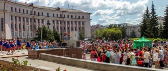
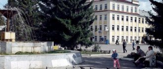
Sterlitamak is one of the largest and most beautiful cities in Bashkortostan.
The satellite map of Sterlitamak shows that this settlement is surrounded on one side by the Ural Mountains, and on the other by the East European Plain.
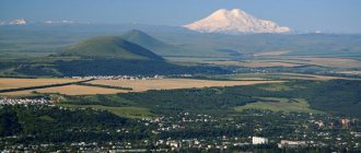
One of the mountains, Shikhan, is listed in the Red Book.
The map provides all possible assistance in finding the desired object. It makes it easy to walk along the streets of an unfamiliar city and find the addresses of all historical or architectural attractions.
Since the city is considered the largest engineering center, as well as a major center of the chemical industry, the map of Sterlitamak will help you find all major objects.
Location and geography of Sterlitamak
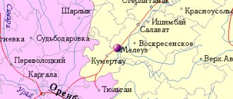
Sterlitamak on the map of Russia is located in the Republic of Bashkortostan (Volga Federal District of the Russian Federation).
This is the second most populous city in Bashkiria, with a population of 276,394 people as of 2021. According to the territorial division of the subject, it is the administrative center of the Sterlitamak region, but is not part of it. Received the status of a city of republican significance. The map scale is adjusted by the “+” and “-” symbols on the side. Today Sterlitamak is considered the leading link in the industrial cluster of the Trans-Ural region (with specialization in mechanical engineering, oil refining and the chemical industry). Industrialization was facilitated by a successful geographical location with an extensive network of transport arteries.
Of the major Russian cities, Izhevsk (460 km), Samara (584 km), Kazan (610 km), and Yekaterinburg (617 km) are close to Sterlitamak. At a 30-kilometer distance from Sterlitamak there are two Bashkir cities, Ishimbay and Salavat. They form a single polycentric agglomeration. By order of the head of government Mikhail Mishustin, a special economic zone (SEZ republic) with a total area of 470 hectares was formed here in 2021.
Legends about the shihan of Toratau
Several beautiful legends are associated with the mountain.
In one of the Toratau caves, an enraged father imprisoned his daughter, the beautiful Diafet, because she wanted to run away with a Russian warrior. The entrance to the cave was guarded day and night by snakes. The serpent, anticipating his own death, filled the cave with stones. The beauty is still waiting for her savior. The one who frees her will receive treasures, extraordinary strength and invulnerability.
© Olegfoto-sk
A legend about another beauty is also associated with these places. The ruler's arrogant son, Ashak, fell in love with young Agidel. The girl did not share the feelings of the young man; he killed her lover. Then Ashak kidnapped Agidel, but she managed to escape. The young man nevertheless overtook the girl, his horse fell in front of her. In desperation, she begged for help and turned into a fast river. Ashak was now trying to catch up with the river, but it was slipping through his fingers. Then he threw his heart of stone at her feet.
The river stopped for a moment, touched the stone and rushed further, to sister Kama and mother Volga.
Since then, four shihans have stood here, fragments of his stone heart - Yuraktau, the double-humped mountain Kushtau, the peak of Shakhtau. And the lonely shihan Toratau.
© Evrichka
Geographical characteristics of this city - relief, reservoirs, forests
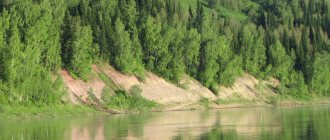
The Sterlitamak region is located on a gently ridged part of the Pribelskaya Plain. Erosion processes are frequent here, and the relief is interspersed with plains and ridges, residual hills. The average absolute height of the earth's crust is 150-210 m.
The calling card of Sterlitamak and the region are the shikhans (single mountain hills), which stand out spectacularly against the background of the plains and steppes. There are many of them throughout the territory, and Yuraktau, Kushtau, and Toraktau, located in the valley of the White Sopka River, are recognized as natural monuments of republican significance.
The soils are represented by leached and typical chernozems. The thickness of the humus layer reaches 40-65 cm, the top layer contains up to 10-12% humus. Also represented by “spots” are podzolized chernozems, gley, turf, forest, and saline soils.
In pre-industrial times, Sterlitamak and the surrounding area were famous for their forb-grass steppes and meadow-steppe forbs, but due to the activities of the petrochemical industry, fescue-feather grass steppes, devoid of forbs, are encroaching. The forest area of the Sterlitakak district is 13,160 hectares. 6.9% are conifers, 36% are broad-leaved trees, 67% are mixed forests.
Using our map, you can find the nearest rivers, lakes and forests yourself. Routes passing through the city.
Four rivers flow through the territory of the Sterlitamak region:
- small Olkhovka and Sterlya - flow into Ashkadar;
- Ashkadar is a tributary of the Belaya;
- Belaya - a tributary of the Kama;
- Kama flows into the Volga.
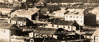
When a pier for transporting Iletsk salt was founded in 1766, the future city was founded in the area between the Ashkadar and Sterli rivers (which at one time gave its name to the city). Over the course of more than 2 centuries, the location has shifted to the left bank of the Belaya, but in the interfluve the historical part of the city has been preserved, where Sterlya and Ashkadar still carry their waters.
Administrative division
The Sterlitamak region includes 20 municipalities and 110 settlements. The territorial structure of the city is the western and eastern parts with their own microdistricts:
- western location – Uralsky, Komsomolsky, Kommunistichesky, Kurchatovsky, Leninsky, Nakhimovsky, Solnechny, Pervomaisky;
- eastern location – Yuzhny, Shakhtau, Ashkadarsky, Zheleznodorozhny, Mikhailovsky, Severny, Sovetsky, Krasnoznamensky.
The territory separator is the railway tracks.
If some object is not on the Yandex map, turn on the 2GIS or OSM map.
The history of Mount Toratau in the Ishimbay region
Ancient peoples believed that by climbing the mountain, you could talk to the Turkic deity - Kuk Tarahe. Toraktau, the area around it and the lake were considered sacred. It was impossible to engage in agriculture here and disturb and, especially, desecrate these places.
The mountain was once a sacred place for the Bashkir people of Yurmaty. Since ancient times, locals have performed pagan rituals on it. On holidays, people from surrounding settlements came to the foot of the mountain. They prepared national dishes, sang and danced. From here brave warriors went on campaigns.
In the 15th–16th centuries, most of Bashkortostan was under the rule of the Nogai Horde. At the top of the mountain was the headquarters of the self-proclaimed khan, Turakhan. The ruins of the fortress could be seen until the 17th century.
© Olegfoto-sk
Here the Bashkirs buried avliya - holy righteous people. The first burial of avliya dates back to the 2nd century BC. Seven such burials were found at the top of the mountain, and eighteen at the foot of Toratau.
In the 20th century, archaeologists discovered a cultural layer here dating back to the Bronze and Iron Ages. Fragments of dishes, jewelry,
In 2010, a memorial sign appeared here - “Stone of Childbirth”, as Bashkir clans gathered here to make important decisions.
During Soviet times, there was a Gulag camp here, where convicted women mined limestone.
Nowadays, many disputes around the mountain do not subside. A local baking soda manufacturer and miner has been trying to get Toratau's environmental status removed for several years.
©
They plan to create a geopark on the territory of the Sterlitamak and Ishimbay districts.
In December 2021, the shihans of Toratau and Yuraktau became candidates for inclusion in the list of UNESCO World Heritage Sites.
Toratau still maintains the continuity of generations. In ancient times, pagan festivals were held here. In June 2021, the ethno-folklore festival “Heirs of the Sarmatians” will be held at the foot of Toratau. The festival will include training in archery, competitions in horseback riding and horse shooting, and national games. Games and competitions are organized for children.
Road transport infrastructure of Sterlitamak
To see the city of Sterlitamak from a satellite with an overlay of roads, streets and house numbers, click the “layers” button and select “hybrid”.
A special feature of the industrial region is its developed transport network. You can get to Sterlitamak by water or railway, by car or plane.
Roads
To get information about traffic jams in Sterlitamak, click the corresponding button on the map.
The road network in the vicinity of Sterlitamak is represented by:
- federal highway Ufa-Orenburg;
- Ufa Highway (access to Sterlitamak);
- Orenburg highway to Salavat;
- regional highway to Krasnousolsky;
- Raevsky tract;
- Sterlibashevsky tract.
There are bypass roads around the city intended for large transit vehicles.
Railway transport
The Ufa-Orenburg section of the Bashkir branch of the Kuibyshev Railway passes through the city. There are 3 stops:
- north of the city – Kosyakovo stop (suburban direction);
- Sterlitamak central railway station – commuter trains and interregional trains stop;
- platform "150 km" in the southwest.
From Sterlitamak stations you can leave in the directions of Ufa, Tashkent, Kumertau, Karlaman. The main disadvantage of the Sterlitamak railway is the low speed of trains.
Water and air transport
The water transport of Sterlitamak lost its ground after the shallowing of the navigable rivers Ashkadar and Belaya in the 1950s of the last century. Now there is no cargo and passenger shipping that is significant for the economy of Sterlitamak.
On the map, the operating airport closest to Sterlitamak is located in Ufa (at a distance of 140 km). The air harbor has international status and accepts all types of aircraft (including wide-body Boeings). Air communication has been established with Adler, Kaliningrad, Moscow, St. Petersburg, Simferopol, Arkhangelsk, Novosibirsk, Min. Vody, Istanbul, Antalya, Dushanbe and other cities. A total of 40 Russian and foreign airlines use it.
Transport infrastructure facilities
Transport connections between Sterlitamak and republican settlements and regions of the Russian Federation are supported by developed infrastructure.
Bus station
Built in the 1960s, reconstructed in the 2000s. State Unitary Enterprise "Bashavtotrans" carries out domestic and interregional transportation across the territory of Bashkiria and Russia. From here you can go to Salavat, Ishimbay, Belebek, Izhevsk, Kazan, Yekaterinburg, Perm. Federal highways connecting Sterlitamak with the constituent entities of the Volga Federal District pass through the bus station.
Railway station
The small, comfortable station building has been in operation since 1934. This is a two-story building that includes spacious waiting rooms, lobbies, rest rooms for passengers with children and passengers with limited mobility, long-term rest areas, and basements with storage rooms. The length of the platforms is 400 m, the width is 3 or 7 meters, the total area of the platforms is 2240 sq. m. m.
Airport
Until 1997, Sterlitamak had its own airport of the same name (15 km southwest of the city). After the departure of the general director, the airport is used by local air lines of Bashkortostan (AN-2, helicopters). Since 2008, the air harbor has been reconstructed, but in the meantime, residents of Sterlitamak fly through Ufa.
Ufa Airport is one of the few in Russia that has received international certificates from IATA and ISAGO as confirmation of the world level of aviation safety, and in 2021 the airport was recognized as the best in Russia. Infrastructure includes:
- 2 runways, taxiways;
- an air terminal with foreign and domestic arrival halls;
- air hotel;
- shops, bars, cafes and restaurants.
The average annual passenger traffic exceeds 3.5 million people. There is a bus service between Sterlitamak and the airport terminal.
Other routing methods
Perhaps the simplest alternative is to open a road atlas and plot a route on the map by eye. Then, by rolling a curvimeter along the route, you can get the approximate mileage. Estimating travel time will be more difficult: to do this, you will have to divide the route into fragments with the same class of roads and measure the sum of the lengths of the fragments of each class. Further, knowing the average speed for each class of roads, it is easy to calculate the time by dividing the distance by the speed.
If you don’t have a curvimeter at hand, you can use a ruler. Place the zero mark of the ruler at the starting point of the route and move the ruler, tightly adjoining it to the curves of the road.
You can also calculate the distance between cities using tables that are published in atlases and reference books. This is quite convenient for routes starting and ending in large cities. Small settlements, as a rule, are not included in the tables.