On the map of modern Karelia you can find many Finnish place names. This is due to the fact that part of the territory of the republic once belonged to Finland. For example, Pitkyaranta district. The name of the city - the administrative center - is Finnish. Pitkäranta is translated as “Long Shore”. And the shore here is not just any body of water, but the famous Lake Ladoga. The settlement has existed since the 18th century and was a village for a long time; Pitkäranta received city status in 1940. Here are its most interesting places and best attractions for your attention.
What to see in Pitkäranta
Of course, from the very beginning about the most famous sights, which you can easily see in one day.
Monument “Cross of Sorrow” and Military-historical complex “Valley of Heroes” (“Valley of Death”)
- Coordinates on the map: 61.667010, 31.516816.
The most important thing for the history of this area in the 20th century was the Soviet-Finnish war of 1939-40. sometimes appearing in historiography as “winter”.
At the site of fierce battles, 19 km from Pitkäranta, there is a memorial complex “Valley of Heroes”, reminiscent of 105 days of battles, tens and hundreds of thousands of dead and missing soldiers from the Russian and Finnish sides. The object is also called “Death Valley”.
The central object of the memorial was a five-meter granite cross, installed here in 2000. It depicts the faces of two women. A Russian and a Finnish woman are two grieving mothers who did not see their sons back from the war. The Cross of Sorrow is a monument to the reconciliation of two peoples. The authors of the monument are Karelian sculptors Leo Lankinen and Eduard Akulov.
“Valley of Heroes” is notable as the first memorial on the territory of modern Russia dedicated to a military conflict, which is very often kept silent, forgotten and understated.
Ladoga skerries
- GPS coordinates: 61.580350, 31.413450.
The deepest lake in Europe, Ladoga, is one of the pride of Karelia. Here it can be seen in all its glory. One of the attractions of the lake for which tourists travel to the Ladoga region is the so-called Ladoga skerries. It is a series of small rocky islands.
They are separated from each other by narrow straits, which can be called a kind of “Karelian analogue” of the famous Norwegian fjords. The Ladoga skerries attract with their amazing post-glacial landscapes, beautiful views and the opportunity to relax on the water.
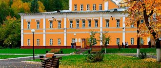
Pitkyaranta Local History Museum named after. V.F. Sebina
- Address: st. Lenina, 46.
The local museum was founded in 1969; its background began four years earlier and is connected with the work of the Red Rangers search party. It was led by a teacher named Vasily Fedorovich Sebin.
Today the institution bears his name. Initially, the museum was called the Museum of Glory, and its main theme was the Finnish War; the status of a local history museum was awarded in 1999.
The building in which the exhibition is located is interesting in itself. This is a historical building of the first half of the 20th century, the only example of Finnish fundamentalist architecture preserved in the Pitkäranta region. During the Winter War, the house served as headquarters for Finnish troops.
The museum has several permanent exhibitions dedicated to the Finnish war and other episodes of the history and culture of the region. The exhibition tells about the history of the city, the nature of the Ladoga region, and demonstrates examples of decorative and applied art.
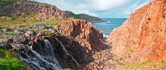
White Bridges Waterfall
- Coordinates: 61.753398, 31.410127.
One of the most famous natural objects of the Ladoga region is the White Bridges waterfall. Initially, it bore the Finnish name Yukankoski; the current name in Russian has been assigned to the waterfall since the 1970s. The waterfall is located near the village of Leppäsilta, on the Kulismajoki River.
This is one of the many small rivers of Karelia. The waterfall is not comparable to the powerful, world-famous giants; in appearance it looks more like a cascade. Why is he interesting? The height of the water fall is 19 meters. This is not so little. The spectacle is impressive. In addition, the places here are incredibly picturesque.
Protruding rock formations add color to the landscape. Tourist infrastructure is developed around. There are observation decks. The waterfall is separated from Pitkäranta itself by a distance of 30 kilometers; the city often becomes the starting point of the route to the attraction.
Impilahti village
- Coordinates: 61.670838, 31.157760.
The village, 28 km from Pitkäranta, officially has historical status, and therefore is a landmark in itself. There are a number of interesting objects dating back to different periods of history. The village has been known since the 16th century. Over the years it belonged to Sweden, Finland and Russia.
To this day, the characteristic Finnish layout and some historical buildings, including a bank and a priest's house, have been preserved here - these are monuments of Finnish architecture. Impilahti became a place where two traditions of building and organizing rural settlements met - eastern and western.
The tradition of “compact” construction, which dominated among the northern Karelians, was supplemented and mixed with the customs of settlers from Saavo, which was reflected in the appearance of the settlement. The mass graves of fallen soldiers of the Soviet-Finnish war remind us of the tragic events of the 20th century on the territory of the rural settlement.
Population
| Population | ||||||
| 1959[9] | 1970[10] | 1979[11] | 1989[12] | 1996[13] | 1998[13] | 2000[13] |
| 6204 | ↗10 251 | ↗13 839 | ↗14 361 | ↗14 700 | ↘14 500 | ↘14 400 |
| 2001[13] | 2002[14] | 2005[13] | 2006[13] | 2007[13] | 2008[13] | 2009[15] |
| ↘14 300 | ↘13 347 | ↘13 200 | ↘13 000 | ↘12 900 | ↘12 800 | ↘12 616 |
| 2010[16] | 2011[13] | 2012[17] | 2013[18] | 2014[19] | 2015[20] | 2016[21] |
| ↘11 429 | ↘11 400 | ↘11 245 | ↘11 089 | ↘10 945 | ↘10 751 | ↘10 705 |
| 2017[22] | 2018[23] | 2019[24] | 2020[1] | |||
| ↘10 589 | ↘10 479 | ↘10 307 | ↘10 184 |
As of January 1, 2021, in terms of population, the city was in 910th place out of 1115[25]cities of the Russian Federation[26].
Natural attractions in the vicinity of Pitkäranta
In addition to the “White Bridges”, in the Pitkäranta region, including in the immediate vicinity of the city of Pitkäranta, there are several more remarkable waterfalls. The area is also famous for other unique natural sites to which tourists traditionally go.
Upper and Lower Koirinoya waterfalls
- GPS coordinates: 61.651567, 31.411950.
Koirinjoki is a 22-kilometer-long river that flows through the territory of the Suoyarvi and Pitkäranta regions of Karelia and flows into Lake Ladoga.
Very close to the confluence of the river with the water giant, 8 km from Pitkäranta, there is a six-meter two-stage waterfall Nizhny Koirinoya. It’s easy to get to, because the Federal Highway is literally 100 meters away. The path leads directly to the foot of the object, you can examine it “from top to bottom” and take interesting pictures.
But its brother, located upstream, and accordingly called Upper Koirinoya, is considered much more inaccessible to visit.
Laskelya Waterfall
- Coordinates: 61.762167, 31.003179.
Another noteworthy Ladoga waterfall is located on the Yanis River. The name of the river is translated into Russian as Hare, and the waterfall, like the surrounding settlement, is called Lyaskelya. It was formed artificially as a result of the construction of a wood processing plant on the river bank.
A low, gentle waterfall is sometimes called a “threshold.” This is a seething section of the river that looks very impressive. Drivers passing through the village of Lyaskelya are often “distracted” by it, because an excellent view of this natural object opens just from the road bridge.
Andronovsky Waterfall
- Coordinates: 61.754907, 31.334685.
Officially, the Nameless Waterfall, formed on a stream flowing along the bottom of a small canyon, is named after the name of the nearby lake - Andronovsky, from where the stream flows. There is also a second name - Roskelakoski, in honor of a nearby farm. Located near the White Bridges, a forest path leads to the stream.
Uskinsky lake
- Coordinates: 61.624045, 31.778550.
The geological monument in the vicinity of Pitkäranta is the legacy of the glacier and clear evidence of its activity. Uskinsky Lake is a system of stone ridges 10-20 meters high, formed mainly from boulders.
mountain pine
- Coordinates: 61.566514, 31.531256.
An area of just over half a hectare in the city of Pitkäranta is occupied by a protected zone where a special type of pine grows - mountain pine, characteristic of central and southern Europe. In total, you can find 3 varieties of pine trees here, which are about 60 years old.
As you know, pine is a tree that is unpretentious to soil quality, which is why it grew on the infertile Karelian soil, but clean air is an important factor for trees with healing properties. Since 1984, the areas where mountain pine grows have been considered a natural monument of regional significance.
Kitelskoe garnet deposit
- Coordinates: 61.687889, 31.316886.
On the territory of the modern Pitkyaranta region, the village of Kitelya existed since 1500. Nowadays it is abandoned, but not far from it there is a unique deposit of a rare precious stone - almandine garnet. It is considered the largest in Russia and is still in operation.
Mention of the deposit dates back to 1804 in the work of Academician Severgin, where he compares the local pomegranate with blackberry juice. This stone is known to have healing properties.
Climate
- Average annual air temperature - 2.7 °C
- Relative air humidity - 79.3%
- Average wind speed - 3.0 m/s
| Average daily air temperature in Pitkäranta according to NASA[8] | ||||||||||||
| Jan | Feb | Mar | Apr | May | Jun | Jul | Aug | Sep | Oct | But I | Dec | Year |
| −9.9 °C | −9.3 °C | −5.0 °C | 1.8 °C | 8.9 °C | 14.0 °C | 16.4 °C | 14.0 °C | 9.1 °C | 3.5 °C | −3.8 °C | −8.4 °C | 2.7 °C |
Historical sights of the city of Pitkäranta
In Pitkäranta there are several places significant for the history of the country that are a must-see for tourists.
Line U
- Coordinates: 61.626384, 31.494430.
6 km from Pitkäranta near Lake Nietjärvi, a line of Finnish defensive structures erected in December 1943 has been preserved. The Finns called it U-asema. The rival troops owe its construction to the designer, Major of the Finnish troops Yrjo Urtona.
The construction of the defensive line was completed by the summer of 1944. During the Petrozavodsk-Svir operation, a battle took place here between Russian and Finnish troops, known in historiography as the Battle of Nietjärvi, during which Line U was tested in battle.
Pogrankondushi village
- Coordinates for the map: 61.256730, 32.204378.
The name of the village Pogrankondushi speaks for itself. Historically, the territory of the settlement, known since 1568 and previously called Kondushi, became a place where the interests of Russia and Sweden intersected. Later it turned out to be a “border zone” between the USSR and independent Finland.
There is a border stone in the village that marks the Russian-Finnish border of 1939. Every year, the military-historical festival “Karelian Frontiers” takes place here, bringing together lovers of historical reconstruction.
Varashev Stone
- Coordinates: 61.237019, 32.173545.
The so-called Varashev stone, located near the village of Pogrankondushi, reminds us of the Russian-Swedish disputes over the territory of the current Pitkäranta region. It marks the border between the states, established in 1617 as a result of the Stolbovo Peace Treaty and valid until 1721, when the Russians defeated the Swedes in the Northern War.
Soviet defensive structures 1939-1940.
- Address: village Border condushi.
The border nature of the village of Pogrankondushi made it logical to build defensive structures here on the Soviet side. They are located 2 kilometers from the village and were built in the 1930s as protection against possible Finnish aggression. The fortifications are one-story reinforced concrete structures with loophole windows for artillery fire.
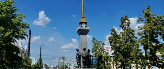
Memorial with the Tomb of the Unknown Soldier
- Address: Gogol street.
The main city of the region, which experienced the hardships of two wars at once - the Winter and the Great Patriotic War - simply cannot do without a war memorial. The Tomb of the Unknown Soldier in Pitkäranta is located in the very center of the city, in a park near the intersection of Rudakov and Gogol streets. The memorial, which appeared here in 1977, is the work of the Petrozavodsk architect of Estonian origin Yuri Yukhanovich Karma.
HPP Uuksu
- Coordinates: 61.512151, 31.600468.
Due to the abundance of rapids rivers, the Pitkäranta region has historically been a fertile place for the construction of power plants. More than 120 years ago, in 1897, a similar infrastructure facility was erected on one of the rapids of the Uksunyoki River, near the village of Uuksu.
The power plant was designed to ensure the operation of an iron processing plant operating nearby. Today, all that remains of the hydroelectric power station are ruins, which are considered a landmark in industrial history.
Pieni Yukakoski hydroelectric power plant
- Address: pos. Salmi.
The power plant on the Tulemajoki River near the village of Salmi is closed to the public as it is still operational. You can only see it from the outside, but this does not detract from the status of a landmark, because the object has reached its age.
The hydroelectric power station was put into operation back in 1920. During the Great Patriotic War it was destroyed and later restored. A three-meter-high dam built on the river forms a massive “artificial” waterfall.
Mäkisalo refuge settlements
- Coordinates: 61.680169, 31.019105.
Myakisalo is one of the islands of Lake Ladoga, which is often visited when traveling through the Ladoga skerries. The name of the island is translated from Finnish as “Hilly Forest”. It also has a local name – Shkolny.
The ancient settlers of Karelia used it as a refuge, so the island is remarkable not only as a natural, but also as a historical site.
Two settlements, which are archaeological monuments, were discovered here. The oldest of them dates back to the second millennium BC. The second refuge settlement is much younger, dating back to the 14th century.
Symbolism
Main articles: Coat of arms of Pitkäranta
and
Flag of the Pitkyaranta urban settlement.
The coat of arms and flag were approved on September 15, 2021.
- Where is the city of Ruza located in the Moscow region?
Description of the coat of arms:
| In a green field under an azure (blue, light blue) wavy head, encumbered at the waist with a scroll, bordered with silver, double-threaded with black - two picks crosswise and on top of them - a vesuri (national Karelian lopper). All figures are silver. The shield is topped with a municipal crown of the established pattern |
Flag description:
The flag is a rectangular panel with a flag width to length ratio of 2:3, reproducing the composition of the coat of arms of the Pitkyaranta urban settlement in blue, white, green and black colors
Museums and cultural centers of Pitkäranta
Pitkäranta cannot boast of an abundance of museums, but in some settlements in the region there are interesting exhibitions that are worth visiting for passing tourists.
Museum "At the Master"
- Address: st. Central, village Rautalahti.
In the village of Rautalahti on Tsentralnaya Street there is a nice wooden house where guests will always be warmly received and introduced to the life and culture of the Ladoga region, household items and handicrafts will be demonstrated.
This museum is also notable for its collection of Karelian minerals. And it is called “Museum at the Master”. From the name you can understand that everything that served as material for craftsmen and became the result of the work of an artisan is presented here.
Exhibition of openers
- Address: pos. Salmi.
A truly original and unique museum can be visited in the village of Salmi. To do this, you should come to your local store. The exposition is located right in the sales area and is dedicated to bottle openers. Here are presented devices for opening all sorts of varieties and colors, produced in different countries and in different eras.
This unique collection is the largest in our country. It was assembled by the store owner A. Bondarev. It all started when a friend one day brought him an opener from Finland as a gift. The entrepreneur and enthusiastic collector himself stands behind the counter and happily shows off his brainchild to tourists visiting his store.
Economy
By Order of the Government of the Russian Federation dated July 29, 2014 No. 1398-r “On approval of the list of single-industry towns,” the city was included in the category “Single-industry municipalities of the Russian Federation (single-industry towns) with the most difficult socio-economic situation”[29].
The city is located Tsellulozny. The leading place in the city's economy was occupied by the timber and mining complex.
The city has a railway station. Passenger service was discontinued in 2015.
Beautiful temples and holy places in the surrounding area
Of course, temples and churches are important attractions. So, if a tourist is a pilgrim, then he definitely needs to go to the vicinity of Pitkäranta.
Church in honor of St. book A. Nevsky in the village of Mursula
- Address: Mursula village.
The now dilapidated church, dedicated to the famous ruler of Rus' and Orthodox saint Alexander Nevsky, is an architectural monument built in 1901. It refers to the Valaam Monastery, or rather to one of its monasteries - Germanovsky, which is the northernmost.
Church of the Icon of the Mother of God “Joy of All Who Sorrow” in Orusjärvi
- Address: village Orusjärvi.
The village of Orusyarvi is one of the historical settlements of the Pitkyaranta region. Its main attraction is a wooden church built in 1910. It was consecrated in honor of the icon “Joy of All Who Sorrow.”
It is believed that in the place where the now inactive beautiful temple is located, there was once a monastery, destroyed during the Russian-Swedish war at the beginning of the 17th century. Presumably, the history of the monastery spanned seven centuries.
All that remains of it is a wooden cross, which helped the Valaam monks who arrived in the village calculate the age of the lost monastery. This was evidenced by the inscription made on the cross. Many Orthodox Christians consider the village a holy place, patronized by St. Nicholas the Wonderworker.
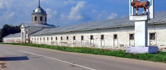
Church of St. Nicholas the Wonderworker in Salmi
- Address: village Salmi.
The church in honor of St. Nicholas the Wonderworker is an architectural monument of Finnish classicism of the 19th century and the main attraction of the village of Salmi. Located in the very center of the village. The authorship of the architectural object belongs to K.F. Engel.
The Finnish architect's project was implemented by local peasants in 1824-1826. After the destruction it suffered during the Great Patriotic War, the church is in deplorable condition and requires restoration.
Rautalahti Temple Hill
- Address: pos. Rautalahti.
The whole complex of seven wooden chapels and the Church of Saints Varlaam and Sergius of Valaam in the village of Rautalahti is a remake. All of them were built in our century and recreate the exact appearance of the lost monuments of wooden architecture of the Russian North.
“Temple Hill” appeared as a result of the implementation of the “Northern Thebaid” project. It commemorates the illustrious tradition of wooden architecture and refers to the history of Russian Orthodoxy of the 14th-15th centuries.
Story
Novgorod land
The village was first mentioned as the Village on the Long Shore near Lake Ladoga
[3] in the census salary book of the Vodskaya Pyatina of the Novgorod land for 1499.
Initially, the village was part of the Nikolsko-Serdobolsky churchyard
, as it was located on the way from Mister Veliky Novgorod to the city of Serdobol. The settlement of Novgorodians on the site of the founding of present-day Pitkyaranta consisted of 3 courtyards, in which about 30 people lived permanently, providing for the Novgorod trade route.
Kingdom of Sweden (1617-1721)
Following the results of the Russian-Swedish War of 1610-1617, according to the Stolbovo Treaty of 1617, the churchyard became part of the Kingdom of Sweden, becoming part of the Impilax Chapel[4]. Lutherans appeared in the city along with the Orthodox population.
In 1632-1634, Kexholm County was formed. It was divided into two parts - northern and southern fief. The “Village on the Long Coast” ended up being part of the northern Kexholm County. During the Russian-Swedish wars, the settlement changed hands over many years.
Russian Empire (1721–1917)
Pitkäranta on the 1908 map.
At the end of the Northern War, according to the Treaty of Nystadt in 1721, all territories of Finland and Novgorod land were ceded to Russia. Since the 18th century, the settlement has been mentioned in Russian documents as a village in the Impilakhtinsky churchyard
, that is, in accordance with the old Swedish name of the settlement Impilax. The Vyborg province was formed on the territory conquered from Sweden.
During the reign of Catherine I (1725-1727), the churchyard belonged to the empress's courtier Count Bruken. In 1727, the Impilakhtinsky churchyard became a palace land, from 1730 to 1764 it belonged to the Alexander Nevsky Monastery, from 1764 to 1797 it was the property of the Imperial College of Economy, and after that it was transferred to the state treasury[5].
In the 1800s in Pitkerando
Mining develops, iron and silver are mined, and
the Pitkerand plant
.
In 1811, the Vyborg province was included by Emperor Alexander I in the newly formed Grand Duchy of Finland, which included the Pitkeranda plant.
- Priozersk in the Leningrad region - what to see, how to get there from St. Petersburg?
In 1847, Salmi County (Swedish: Salmis härad, Finnish: Salmin kihlakunta) was formed with its center in the village of Salmis.
At the end of the 19th century, the city developed rapidly: sawmills appeared, a red ocher mining plant and a glass factory opened, which since 1889 has become one of the main suppliers of bottles in the region.
Finland (1918—1940)
In 1918, the Pitkeranda plant was renamed Pitkäranta and became part of the Vyborg province of independent Finland.
In 1932, traffic opened on a 43-kilometer railway line from Lyaskel to Pitkäranta, and in 1933 the railway continued further - to Ala-Uuksu (Finnish: Ala-Uuksu, Uuksu satama)[6].
USSR
After the Winter War in 1940, the eastern part of the Vyborg Governorate was transferred to the Soviet Union under the Moscow Peace Treaty. The northern part of the new territory was included in the Karelian Autonomous Soviet Socialist Republic, transformed into the Karelo-Finnish SSR. In July 1940, zoning was carried out - among others, the Pitkäranta district was formed with the administrative center in Salmi.
City status was granted on July 9, 1940. During the Soviet-Finnish War of 1941-1944, Finnish troops again occupied the city, but were forced to abandon it in August 1944.[7]
On December 28, 1966, the Pitkyaranta region was restored. Currently, it includes four rural settlements and the Pitkyaranta urban settlement (a city with the villages of Yularistioya, Uuksu, Koirinoya).
Pitkäranta: recreation and entertainment for children
The Pitkyaranta region is a popular destination for tourists who travel to Karelia for outdoor recreation. There are many different recreation centers here.
Karelia Park
- Address: 1A, Kirkonkyulya village, Impilahti.
Fans of active recreation and extreme sports will be attracted by the Karelia Park, which opened near the village of Impilahti. Here you can tickle your nerves by indulging in extreme entertainment: ride a zipline or jump from a steep 45-meter cliff on a rope.
The attraction is called ROPEJUMPING and is only available to tourists over 18 years of age. Karelia Park also organizes for its guests boat trips on Lake Ladoga and trips to the Ladoga skerries with the opportunity to stay overnight on the islands.
Recreation center "Long Beach"
- Address: st. Lenina, 151.
The tourist base of the same name in the city is an excellent place for relaxation and accommodation in Pitkäranta with children - it is located right next to the waters of Lake Ladoga. Here you can stay in a hotel room or in a cottage. Guests have the opportunity to indulge in popular Karelian entertainment - hunting and fishing. Excursion services are organized.
Don't miss the interesting places of other Karelian cities and towns - Petrozavodsk, Kemi, Olonets, Medvezhyegorsk, Kondopoga, Sortavala and Lakhdenpokhya.
Pitkäranta may be of interest to different people: those who love secluded recreation in nature, and those who cannot imagine a vacation without excursions and entertainment. History, nature, unusual exhibitions, festivals - all this is in the Pitkäranta region.
Pulp plant
The former breadwinner of the city, the city-forming enterprise for the production of cellulose, deserves special mention - all types of it are produced here - commercial, electrical insulating and capacitor. In addition to it, they produced pine turpentine and crude tall oil.
It was founded in 1921 by Diesen Wood on the island of Pusunsaari, separated from the city by a narrow part of Pitkäranta Bay. Before the advent of the railway, it was necessary to transport products across Ladoga, and in winter horses saved the day.
Subsequently, the plant was reconstructed more than once and equipped with the most modern equipment, but five years ago the management declared bankruptcy. This event dealt a severe blow to the city’s economy; the outflow of population increased greatly and continues to grow every year.
see also
| Settlements from Vyartsilya to Olonets (Olonets - Vyartsilya highway) |
|
100 ms 4.5% Scribunto_LuaSandboxCallback::getExpandedArgument 40 ms 1.8% Scribunto_LuaSandboxCallback::getAllExpandedArguments 40 ms 1.8% Scribunto_LuaSandboxCallback::match 40 ms 1.8% Scribunto_LuaSandboxCallback::loadPack age 20 ms 0.9% Scribunto_LuaSandboxCallback::getEntity 20 ms 0.9% [others] 20 ms 0.9 % Number of Wikibase entities loaded: 4/400 –> This page was last edited on December 11, 2021 at 5:31 pm.
The sights of Pitkäranta and the Pitkäranta region annually attract thousands of Russian and foreign tourists. The small town on the coast of Lake Ladoga is famous for its historical monuments, cultural heritage sites and, of course, its unique picturesque nature.
Content
Urban areas
- Peräkylä (Finnish: Peräkylä)
The oldest part of the village, where farmers settled, as well as a school and a store. It bordered on other areas of the village - Rannankylä and Petäyäkylä.
- Petäjäkylä (Finnish: Petäjäkylä)
Petäjäkylä started from the Market Square. In addition, an Orthodox church, a public school and a stadium were located here.
- Tarusa city: where it is, how to get there, attractions, reviews
- Rannankylä (Finnish: Rannankylä)
There was a railway station, a train station, a Russian school, a pier, a shopping center, a post office, a pharmacy and an office of the People's Joint Stock Bank.
- Riseyus (Finnish Riseys)
There was the building of the defense organization Suoeluskunta (schuetskor) and a casino[30].
- Tehdas (Finnish Tehdas)