This term has other meanings, see Ertil.
| urban settlement | |
| Ertil | |
| Flag | Coat of arms |
no)[3]Digital identifiersTelephone+7 47345Postal code397030OKATO20258501000OKTMO20658101001OtherCity DaySecond Saturday of Julyertilcity.ru Ertil
Moscow
Voronezh
Ertil
Media files on Wikimedia CommonsErtil
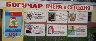
- a city (since 1963[4]) in the Voronezh region of Russia, the administrative center of the Ertilsky district and the urban settlement of Ertil.
Ertil railway station of the Yelets branch of the South-Eastern Railway, the terminus on the branch from Oborona station on the Gryazi-Povorino line.
Population - 10,052[2] people. (2020).
Geography[ | ]
Ertilsky district is located in the northeast of the Voronezh region and borders the southern regions of the Lipetsk and Tambov regions.
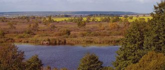
The city is located on the Ertil River (Don basin), 112 km from Voronezh[6], 10 km from the border with the Tambov region and is the northernmost of all cities in the region. In natural-geographical terms, the area is in the south of the forest-steppe zone.
Temperate climate prevails. About 512 mm of precipitation falls annually. The least precipitation falls in February, with an average of about 27 mm, and the most in July, with an average of about 66 mm. The warmest month is July with an average temperature of 20.4 °C, and the coldest month is February, with an average temperature of −9.4 °C.
Links
- Ertil Information Portal
- Expedition of governor I. I. Tevyashov to the Bityug and Osered rivers in the fall of 1698. Vasilenko D. V.
- Ertil // Encyclopedic Dictionary of Brockhaus and Efron: in 86 volumes (82 volumes and 4 additional). - St. Petersburg, 1890-1907.
| Municipalities of Ertilsky district | ||
| Urban settlement: Ertil Rural settlements: Alexandrovskoe | Bityug-Matrenovskoye | Bolshedobrinskoe | Borshchevo-Peskovskoe | Buravtsovskoe | Morozovskoe | Pervomayskoe | Rostoshinskoe | Samovetskoe | Shchuchinskoe | Shchuchinsko-Peskovskoe | Pervoertilskoe | Yacheyskoe Settlements: Aleksandrovka | Bazhenovka | Begichevo | Bityug-Matrenovka | Bolshaya Dobrinka | Big Samovets | Borshchevo-Peski | Buravtsovka | Vasilyevka | Vvedenka | Veselovka | Vinogradovka | Vladimirovka | Voznesenovka | Revival | Knitting | Rotten | Golevka | Gorokhovka | Muddy | Dzerzhinsky | Dmitrievka | Znamenka | Ivanovka (Ertil settlement) | Ivanovka (Pervomaiskoe settlement) | Israeli | Kolodeevka | Komsomolskoe | Kopyl | Krasinka | Krasnoarmeysky | Malorechensky 1st | Malorechensky 2nd | Malye Yasyrki | Maryevka | Mikhailov | Mikhailovka | Michurinsky | Morozovka | MTF "Voskhod" | Nikolsky | Novogeorgievka | Oktyabrsky | Orlyanovka | Pervo-Ertil | Pervomaisky | Privolny | Prudki | Rostoshi | Sadovsky | Semyonovsky | Sergeevka | Sweetie | Sosnovka | Average Samovets | Old Ertil | Studenovka | Chapaevskoe | Shukavka | Shchuchinsky Sands | Shchuchye | Ertil | Cell | ||
| District centers of the Voronezh region | |||
| Administrative center: Voronezh Anna | Bobrov | Boguchar | Buturlinovka | Upper Mamon | Upper Hawa | Vorobyovka | Gribanovsky | Kalach | Kamenka | Kantemirovka | Kashirskoe | Liski | Nizhnedevitsk | New Usman | Novokhopyorsk | Olkhovatka | Ostrogozhsk | Pavlovsk | Panino | Petropavlovka | Povorino | Podgorensky | Ramon | Repyovka | Rossosh | Semiluki | Talovaya | Ternovka | Khokholsky | Ertil | |||
| Settlements on the Bityug River (from source to mouth) | |
| Novopokrovka | Mordovo | Ertil (on the Ertil tributary) | Anna | Bobrov | Nizhny Kislyai | Losevo | Melguny |
History[ | ]
In the 11th-13th centuries, there were Polovtsian encampments on this land. Founded in the 17th century as the village of Ertyl of the Ertyl yurt.
On September 6, 1698, Voivode Tevyashov conducted a survey of residents of the village of Ertyl. He wrote about the residents of the village like this: “Bityutsk residents of the Ertyl yurt of the village of Ertyl.” From among them, he included the names of several: Boris Telegin, Avdey Ivanov, Miron Filatov, Maxim Putimtsov, Foka Kolitvinov. A total of 28 residents of Ertil were interviewed. Their settlers were also Prokofy Belyaev and Semyon Gundorov.
In 1699, by decree of Peter I, peasants from Vladimir, Kostroma and other districts of northern Russia began to be resettled to the Bityug River. Illegally created settlements along Bityug were destroyed, 1,515 households were burned. This is how the first villages appeared: Bityug-Matryonovka, Shchuchye, Stary Ertil and others.
From Empress Catherine II at the end of the 18th century, Count Orlov, for his services, received a gift of 39,000 acres of land in the Pribituzhye region, which officially became known as the “Ertil Steppe”[5]. After his death on December 24, 1807, the lands passed into the possession of his only heiress, his daughter Anna Orlova-Chesmenskaya.
In 1832, Orlova-Chesmenskaya ceded part of her possessions, called the Ertil steppe, to her relative, Count Alexei Fedorovich Orlov. These lands with a total area of 42 thousand dessiatines were located near the Greater Ertil River.
With the death of the next owner, Nikolai Alekseevich Orlov, in 1885, his inheritance passed to his sons Alexei[7] and Vladimir[8] Orlov, who found more effective ways to increase wealth.
By the end of the 19th century, sugar production had become one of the leading places in the industrial sector of the Voronezh province. Having secured a considerable loan from the State Noble Land Bank, the Orlov brothers organize the construction of a sugar factory. The location for the plant and the village was chosen deliberately. It happened at the intersection of the bank of the clean Big Ertil River and the cattle road.
In 1891, construction of a sugar factory began on the estate by 400 peasants from nearby villages. They became his first workers. In 1897, the construction of a sugar factory on the estate of Count A.F. Orlov “Ertilskaya Steppe” was completed.
Essentially, the plant was the starting point from which the city of Ertil began. The first building of this enterprise was located on the territory of a modern foundry and mechanical plant. Under Prince Orlov, residential one-story buildings were also built and still remain on Sadovaya Street and Sadovaya Square. And the street itself was then called “Nevsky Prospekt”, was paved with cobblestones and was illuminated in the evenings by electric lanterns. The population of the village was 426 men and 32 women (only single young people were hired). After the death of the prince, the estate passed to V.N. Orlov, he turned out to be the last owner of the sugar factory and farms. V.N. Orlov received the highest permission and in three years built a railway on the Oborona (Mordovo) - Ertil section, and in 1915 traffic along this railway line was opened.
Sugar factory in Ertil, 1916
In 1917, after the start of the revolution, in the main building of the sugar factory, the Bolsheviks Ivan Ivanovich Bakulin and Efim Ivanovich Zimoglyal held a meeting and announced the victory of the October Revolution in Petrograd; they called on the workers to have revolutionary consciousness and fight against the bourgeoisie. On January 31, 1918, the Voronezh provincial congress of sugar industry workers, by its resolution, nationalized the sugar factory. At the same time, the surplus appropriation policy began.
During the civil war, Ertil alternated between the whites and the reds. In 1921, the sugar factory was partially destroyed and burned by the Antonovites. The railway station was also damaged. In 1926-1928 the plant was restored. At the same time, the enterprise’s drying shop was built, and the adjacent microdistrict was nicknamed “Drying”.
With the onset of industrialization, the city's economic and social revival accelerates. In accordance with the first five-year plan for the development of the national economy of the USSR (1928-1932), the construction of a new sugar factory began - one of the largest factories in the Central Black Earth Region. Its construction began in June 1931. At first, the laborers lived in dugouts, but at the same time as the plant, a new residential neighborhood was being built (its name “Stroyka” has been preserved to this day). A school, kindergarten and nursery were built for the children of workers moving to new housing in the microdistrict. The new sugar factory was put into operation in February 1934.
To strengthen the plant’s own raw material base, during the first five-year plan, in 1932, two large beet-growing state farms were organized: “Krasnoarmeysky” and “Udarnik”. In 1933, a grain collection point was put into operation. The period from 1932 to 1935 was marked by the construction of houses on the first streets of the Novostroika village, the creation of an inter-district oil depot and the Krasny Pishevik industrial market.
The village of Ertil acquired the status of a “workers’ village” on December 4, 1938. In June 1939, the Ertil Creamery was launched.
Beet drying plant on the territory of the current foundry and mechanical plant during the NEP years
A noteworthy milestone in the history of Ertil was the launch of the glycerin (“G-2”) and butter and cheese factories. The brick factory was already producing bricks at that time. At the beginning of the Great Patriotic War (namely in the summer of 1942, when the Ertil region was declared front-line), the glycerin and sugar factories were evacuated to Kazakhstan, but after the war only one returned - the sugar factory.
During the war, the Ertilians donated 210 thousand rubles to the fund for the construction of a tank column. We collected food parcels for the front. Small-caliber mortars were manufactured in the sugar factory workshops, and U-2 aircraft engines were repaired on platforms at the Ertil railway station. More than 23 thousand Ertilians fought at the front. On June 23, 1941, the first mobilization of Ertilians into the active army took place. School No. 1 housed a hospital where residents of the working-class village served the wounded.
In the first post-war year of 1946, the Voronezh region, like other regions of the Central Black Earth Region, was engulfed in severe drought. On September 16, 1946, the USSR Government established monetary compensation to the population at 100-110 rubles for medium- and low-income categories of citizens (the so-called “grain allowance”), and on November 9, 1946, the Council of Ministers of the USSR adopted a resolution “On the development of cooperative trade in food and industrial goods and on increasing the production of food and consumer goods by cooperative organizations” in order to improve the situation of citizens. However, famine could not be completely avoided. By the spring of 1947 in the Voronezh region, the number of patients diagnosed with dystrophy was 250 thousand people. However, already in 1947, the labor victories of Ertilian farmers were celebrated, the first Heroes of Socialist Labor appeared and mass awards were held.
In 1958, the MTS was abolished, and the equipment was sold to collective farms. In May 1959, passenger air service began on the Voronezh - Ertil route.
On February 1, 1963, the workers' village of Ertil was given city status. The workers petitioned the Supreme Soviet of the RSFSR to transform the village of Ertil into the city of Sovetsk. The petition was accepted, but the city retained its previous name.
In June 1963, by decree of the Presidium of the Supreme Soviet of the RSFSR, the city of Ertil was transferred to the Anninsky rural district[9].
In the fall of 1963, Ertil football players took second place in the Russian championship.
In 1967, a high-voltage power line came to the area, and Ertil was included in the country's energy system. Until 1967, large enterprises, social and cultural facilities, and residential buildings were serviced by diesel engines. The line was pulled from Borisoglebsk in February. In blizzards and frost, the Ertilians went out to the highway as a whole, knocked off the stuck snow from the wires, manually chiseled the frozen earth under the poles, and helped to tension the wires.
The mechanical plant, which was formed from auto repair shops created in 1949, plays a special role in the history of the city. At first, only car engines were repaired here. And in 1958, by decree of the Voronezh Economic Council, the Ertil machine repair workshops were renamed the Ertil Mechanical Plant. This was the only enterprise that produced equipment for preparing feed for animal farms in our country.
In the late 1960s, the first street in the city was paved. In the 1970s and the first half of the 1980s, noticeable changes in the economy and culture took place in the life of the city. The appearance of the city has changed. Enterprises and organizations of great importance for the region were created. In 1973, a forest reclamation station (now a forestry enterprise) was organized. Before its appearance, there were only 1% of forests, after - 3.4%. Through the efforts of this enterprise, an entire residential microdistrict was built, thousands of hectares of forests were planted. A television repeater, a sports complex and stadium, a bath and laundry plant appeared, a local history museum was opened (1974), a market was landscaped, a regional communications center was put into operation, a new grain collection point or elevator appeared (1972), and a new co-op department store was opened in 1973. More than 10 thousand hybrid tea roses were planted in the central square and main street of the city, chestnuts and ornamental shrubs appeared. The city was transformed beyond recognition and was recognized four times as the winner of the All-Russian competition for the improvement of cities and regional centers (1971-1975). More than 40 km of sidewalks and streets of the city have been paved, and a monument to the Ertilians who died during the war has been unveiled. From 1974 to 1979, standard buildings of Ertil schools No. 2 and No. 3 and a training and production plant (TPK) were rebuilt and put into operation. In 1975, the construction of the Voronezh-Ertil asphalt road was completed. In 1976, the Ertilraygas association was organized. In 1979, a hospital complex with 240 beds and a clinic was opened.
The modern administration building (until August 1991 - the district committee of the CPSU) was put into operation in 1982. In October 1994, an important event took place for the city and region - the new Church of the Iveron Icon of the Mother of God in the city of Ertil was consecrated[10]. In 1995, the “Book of Memory of the Ertil Region” was published. In 1997, modern buildings of Sberbank and the tax office were opened.
Ethnographic installation
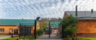
Over time, many items from the museum collection migrated to other objects of the ethno-village - to a Russian hut with a real stove, to a weaver's house, to a blacksmith's workshop, to a fisherman's hut, to an apiary and to a dugout. You can go into each of these buildings and find out how and what was built in them a hundred or two years ago. Right there on the territory there is an observation tower (the territory of Ertil hundreds of years ago was borderland and was attacked by nomadic tribes) and a real windmill.
Entertainment is provided for guests: wallowing in the hayloft, pillow fights, log swings on which you need to keep your balance, ropes stretched over a pond through which you need to walk without falling into the water. Sometimes newlyweds come to the ethno-village: they have come up with their own romantic adventure here. The bride and groom must cross seven bridges and complete certain tasks - write letters to each other, launch paper boats, hang a castle, and so on.
Chronicle[ | ]
- 1688 - first mention of Ertil;
- 1897 - completion of the construction of the princes Orlov sugar factory;
- 1915 - start of operation of the Mordovo - Ertil railway line;
- 1921 - burning of a sugar factory by Antonovites;
- 1928 - start of operation of the Beet Dryer;
- 1934 - launch of a modern sugar factory;
- 1935 - opening of Ertil secondary school No. 1;
- 1938 - formation of a district with an administrative center in Ertil;
- 1939 - the beginning of publication of the regional newspaper;
- 1958 - organization of a mechanical plant;
- February 1, 1963 - obtaining city status;
- 1967 - creation of the Ertil electrical network;
- 1968 - creation of PMK-706;
- 1974 - opening of a museum, a communications center, and secondary school No. 2;
- 1975 - start of traffic on the Voronezh - Ertil highway;
- 1979 - opening of the hospital complex;
- 1980 - organization of an experimental mechanical plant;
- 1994 - consecration of the church (temple in honor of the Iveron Icon of the Mother of God);
- 1997 - commissioning of the buildings of Sberbank and the tax service;
- 2003 - opening of the Sokolov school;
- 2004 - launch of a vegetable oil plant;
- 2006 - launch of the gas complex.
Population[ | ]
| ↗16 000 | ↘12 648 | ↗13 162 | ↗14 144 | ↗14 300 | ↘14 200 | ↘13 900 | ||
| 2000[11] | 2001[11] | 2002[16] | 2003[11] | 2005[11] | 2006[11] | 2007[11] | 2008[11] | 2009[17] |
| ↘13 700 | ↘13 500 | ↘12 885 | ↗12 900 | ↘12 400 | ↘12 200 | ↘12 100 | ↘11 900 | ↘11 755 |
| 2010[18] | 2011[11] | 2012[19] | 2013[20] | 2014[21] | 2015[22] | 2016[23] | 2017[24] | 2018[25] |
| ↘11 387 | ↗11 400 | ↘11 168 | ↘11 018 | ↘10 835 | ↘10 740 | ↘10 575 | ↘10 410 | ↘10 265 |
| 2020[2] | ||||||||
| ↘10 052 |
As of January 1, 2021, in terms of population, the city was in 923rd place out of 1116[26]cities of the Russian Federation[27].
Culture, science, education[ | ]
Currently, there is a local history museum in Ertil, the exhibits of which are constantly being replenished. Its attraction is the work of the artist Vasily Nikolaevich Silin, who donated more than 40 paintings to the museum. In the city of Ertil there is a cinema "Rodina", which shows domestic and foreign films. On the outskirts of the city there is an open-air ethnographic museum complex “Village of the 17th-19th centuries”, created by the honored farmer of Russia Vladimir Brezhnev[28][29].
Also in Ertil, the Power-metal group “VERSION” began its existence in 2006.
Currently, there are six secondary schools, one vocational school, a music and sports school, a house of pioneers (schoolchildren), a palace of culture, and a city library in Ertil.
Museum of Peasant Life
One of the objects of the “village” is a museum of peasant life, which contains hundreds of exhibits: tools, tools, interior items and everyday life of residents of the Voronezh province. Here you can even find “overseas” machines used by local farmers, for example, a straw cutter manufactured in London at the beginning of the 20th century. But the main value of the museum is the loom, which, despite its considerable age (about 200 years), continues to work. Local craftswomen even wove several rugs on it.
Honorary citizens of Ertil[ | ]
- Silin, Vasily Nikolaevich. Born in 1918. The front-line artist donated more than 40 canvases to the museum and for a long time maintained close ties with the city, considering it the best place on earth. One of the streets of Ertil is named after him. He was buried in Lipetsk.
- Goleva Ekaterina Ivanovna, born in 1923, native of the village of Shchuchye. Participant of the Great Patriotic War. From 1948 to 1981 she worked as a librarian, then as director of the district library. Headman and active member of the choir of war and labor veterans. The main participant in the work on the “Book of Memory of the Ertil Region” (1995). Lives in Ertil.
- Obryvko, Mark Dmitrievich, born in 1909. Design engineer, inventor and innovator, head of the design bureau at a sugar factory - the predecessor of the experimental mechanical plant. Laureate of the State Prize. For his success in creating mechanisms for the sugar industry, in 1966 he was awarded the title of Hero of Socialist Labor. Died in 1999. He was buried in Ertil.
- Belolipetsky Boris Ivanovich, born in 1927. During his years as chief specialist and then director of the sugar factory (1947-1979), reconstruction and a noticeable increase in labor productivity took place. Under his leadership, the construction of housing, cultural and everyday objects was carried out in the Stroika microdistrict. Died in 2001. He was buried in Ertil.
- Zhukov Ilya Gerasimovich, born in 1935, native of the village of Krivka. He worked as a designer at the Obryvko Design Bureau M.D. From 1972 to 1994 - director of a mechanical plant. These were years of stable development, active housing construction along Truda and Plekhanovskaya streets. Died in 2003. He was buried in Ertil.
- Valikova Alexandra Vladimirovna, born in 1937. Veteran of cultural activities in the area. She devoted about 50 years of her life to the popularization of Russian song. Soloist of the choir of war and labor veterans. Lives in Ertil.
- Zavyalov Alexander Ivanovich, born in 1926. Director of the Sokolov school from 1965 to 1999. Innovative teacher with 49 years of experience, scientist. Through his efforts, a memorial complex near the school and the natural environment, a museum of Russian folk crafts and much more were created. Honored Teacher of Russia. Died in 2001. He was buried in Ertil.
- Shmatov Ivan Fedorovich, born in 1920. From 1951 to 1956 - First Secretary of the Republic of Kazakhstan CPSU. In those years, the district occupied a leading position in the region in the grain industry and milk yield. In 1956 he was awarded a large gold medal of the All-Russian Agricultural Exhibition and a Pobeda car. Lives in Voronezh and maintains active contacts with the city.
- Kondaurov Mitrofan Romanovich, born in 1927. Veteran law enforcement officer, Lieutenant Colonel. From 1970 to 1982 - head of the Ertilsky District Department of Internal Affairs. During these years, the district police department occupied leading positions in the region. A lot of educational work was carried out with the team of employees. Has ten government awards. Lives in Ertil.
- Subbotina Natalya Ivanovna, born in 1940. She began her activities in the Ertil region in 1965 as an accountant-economist of the Ertil Department of Agriculture. From 1972 to 1978 she worked as a manager of the State Bank of the USSR. From 1978 to 1991 She held the position of secretary and then first secretary of the RK CPSU. From 1966 to 1991 - deputy of the district and one convocation (since 1980) of the regional Councils of People's Deputies, delegate of the XXVI - XXVIII Congresses of the CPSU. Under the leadership of Natalya Ivanovna, the construction of new schools, roads, cultural facilities, etc. was carried out in the area. From 1991 to 1996, she was deputy director of the Krasnoarmeysky state farm. From 2002 to the present, he has been deputy head of the district Veterans Council and secretary of the Ertil branch of the Communist Party of the Russian Federation. The title “Honorary Citizen of Ertil” was awarded in 2003. Lives in Ertil.
- Viktor Fedorovich Zharenko, the first director of the newly formed sports school, made an invaluable contribution to the development of sports (especially gymnastics and basketball).
Wildlife sanctuaries and reserves of the Voronezh region
The nature and landscape of the Voronezh region are so unique that you want to preserve every part for future generations. Therefore, nature reserves occupy one of the most significant places in the development of the region.
Voronezh Biosphere Reserve
- Coordinates on the map: 51.942180, 39.597760.
At the beginning of the 20th century, it was believed that almost the entire beaver population in Russia had already been exterminated, until a group of scientists discovered several settlements on the Usmanka River. They turned to the People's Commissariat of Agriculture of the RSFSR with a request to create a reserve in these places in order to preserve this valuable game animal, and the request was granted.
In 1932, an order was signed to create the world's first experimental beaver reserve, and two years later scientists received the first offspring.
Little beaver cubs were settled all over the world. Descendants of the same animals discovered at the beginning of the century live today even in Lapland. In the reserve, the beavers have a real town, equipped with the latest technology, and the Beaver News newspaper is published. The animals also welcome guests with pleasure.
Divnogorye
- Address: Divny lane, 25, Divnogorie village.
Here, on an area of more than 17 hectares, many relict plants and animals have been preserved, many of which are listed in the Red Book of Russia. In addition, the reserve also has the status of an archaeological museum and a natural monument of federal significance.
Its main attractions date back to different eras, but the most common are monuments from the Bronze Age, the Middle Ages and the Paleolithic.
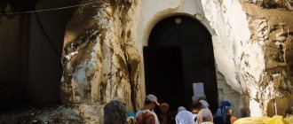
The main decoration of the reserve is the church, which is located inside the chalk mountain. It was hollowed out at the beginning of the 19th century by monks and consecrated in honor of the Sicilian Icon of the Mother of God.
Lomovsky Landscape Park
- GPS coordinates: 50.759986, 41.175112.
Loma Farm, one of the most interesting places for lovers of ethnotourism, is located almost on the border with the Volgograd region. It constantly hosts various kinds of festivals, and there is entertainment not only for adults, but also for children.
No one will be bored. You can swing on a wooden swing in the so-called Dead Forest, visit a stone labyrinth or a sauna. And then drink herbal tea from 10 types of medicinal plants growing right in the park. Many of them are relicts, preserved from ancient times.
Many species of wild animals and birds have found shelter here. The pond is inhabited by fish, and on the shore there is a completely restored water mill, giving the attraction an old Russian flavor.
Khopersky Reserve
- Coordinates: 51.234150, 41.736416.
It was created to preserve the muskrat population living in the Khoper River valley in 1935. But the main asset of the reserve is its rich flora. More than 80% of its area is covered with a variety of flora, of which there are about 1,200 species.
Some relict plants have also been preserved here, for example, water chestnut - chilim. Many animals and birds living in the reserve are rare and are listed in the Red Book.
Zoo nursery Chervleny Yar
- Address: Smorodinovaya st., 2D, Voronezh.
This zoo complex is a branch of the Voronezh Zoo, but is located in a forest belt, on the shore of the Voronezh Reservoir. Most of its inhabitants are ungulate mammals, such as roe deer, deer, yaks, and bison.
But there are even wild boars, guinea fowl, and mouflons. For visitors, eco-trails have been developed here, passing in the shade of man-made plantings, and a rock garden, where you can not only experience Zen, but also admire various rock formations.
Stone steppe
- Coordinates: 51.036038, 40.735479.
This unique reserve is of great importance not only for the Voronezh region, but also for the whole world. After all, studies of human economic activity on the soil layer have been conducted on its territory for more than a hundred years.
The main attractions of the reserve are:
- centuries-old deposits of arable, but left unsown lands,
- Dokuchaevskoye Reservoir, most often called the sea,
- the first forest belts laid out in the 19th century;
- unique landscape and fauna, where marmots are the main ones.
Don't miss: Where to go with a child in Voronezh
Leaders of the city of Ertil[ | ]
- Zamotaeva Natalya Ilinichna (1963-1965) - chairman of the executive committee of the city Council of Workers' Deputies
- Lavrov Vladimir Dmitrievich (1966-1971) - chairman of the executive committee of the city Council of Workers' Deputies
- Filonov Nikolai Nikitovich (1971-1974) - chairman of the executive committee of the city Council of Workers' Deputies
- Golev Ivan Vasilievich (1974-1977) - chairman of the executive committee of the city Council of Workers' Deputies
- Kachurin Valentin Maksimovich (1977-1978) - chairman of the executive committee of the city Council of People's Deputies
- Bakhtin Ivan Ivanovich (1978-1982) - chairman of the executive committee of the city Council of People's Deputies
- Kretinin Nikolai Tikhonovich (1982-1989) - chairman of the executive committee of the city Council of People's Deputies
- Kuznetsov Nikolai Ivanovich (1989-1991) - Chairman of the Executive Committee of the City Council of People's Deputies
- Krylov Vladimir Aleksandrovich (1991-1993) - chairman of the executive committee of the city Council of People's Deputies, head of the city administration
- Kryukov Pyotr Iosifovich (1993-1998) - head of the city administration, chairman of the city council
- Glushchenko Evdokia Mikhailovna (1998-2002) - head of the city administration, chairman of the City Council
- Prokudin Alexander Valerievich (2002 - present) - head of the city administration, chairman of the City Council
Monuments and landmarks[ | ]
| № | Name of the monument | Date of origin | Location |
| 1 | Houses No. 4, 5, 7, 12 | around 1895 | Sadovaya st. |
| 2 | Residential building "Glagol" (demolished in December 2013) | around 1896 | Sadovaya sq. |
| 3 | Sugar factory of the Princes Orlovs (3 buildings) | 1897 | st. Labor |
| 4 | Dam of concrete hydraulic structures | 1910 | 100 m north JSC "ELMZ" |
| 5 | The first building of city school No. 1 | 1935 | Pervomaiskaya st. |
| 6 | Sculpture “Motherland will never forget her sons” | 1957 | Near Sokolovskaya school |
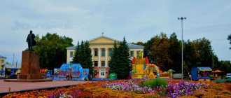
| 7 | Sculpture of V. I. Lenin | 1965 | central square |
| 8 | Obelisk "To the Victims of the White Terror of 1920-1921" | 1967 | st. Lenin |
| 9 | Sculpture of V. I. Lenin | 1970 | At the Palace of Culture of the Sugar Factory |
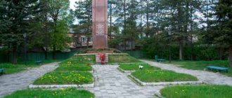
| 10 | Memorial to the fallen Ertilian fellow countrymen during the Second World War with burial | 1975 | Square near the central square |
| 11 | Memorial plaque in honor of the 200th anniversary of A. S. Pushkin | 1999 | On the tax office building, Pushkinskaya street. |
| 12 | Memorial stone “To the Ertil warriors who died in peacetime” | 2000 | Square near the central square of the city |
| 13 | Memorial plaque to E. I. Kabanov - Hero of the Soviet Union | 2000 | On the building of ESOSH No. 1 of the city |
| 14 | Memorial plaque to V. F. Kolbnev - Hero of the Soviet Union | 2000 | At the administrative building of the sugar factory |
| 15 | Memorial plaque to the fallen internationalist soldiers Artyomov A.I., Usov A.I., Yablonskikh A.P. | 1989, 2000 | On a memorial stone in the city park |
| Memorial to the fallen Ertilian fellow countrymen during the Second World War with burial | Sculpture of V. I. Lenin | Memorial plaque to the fallen internationalist soldiers Artyomov A.I., Usov A.I., Yablonskikh A.P. |
Beautiful lakes in the Voronezh region
Strange lakes, of which there are many on the map of the Voronezh region, are more the norm than the exception to the rule. Mysterious and interesting, they are considered one of the most visited places.
Turtle Lake
- Coordinates: 51.820053, 39.410780.
Not far from the village of Maklok there is another unique natural monument of the Voronezh region. The only body of water where the marsh turtle lives - a very rare, endangered animal. The banks of the reservoir are unusually picturesque. They are covered with trees and bushes.
The lake is quite deep, and on one side it generally turns into a swamp. The vegetation on the other side is denser and creates deep shade. It’s quite easy to see turtles here; they are found at every step and are the main object that attracts tourists here.
Chalk Lake
- Coordinates on the map: 51.649818, 38.990737.
Another reservoir attractive to travelers is located in the Semiluksky district, not far from the village of Orlov Log. Locals call it the Cretaceous Sea, although the body of water itself is small. The place is quite lively.
There are always vacationers on the shore who come to swim, sunbathe or play beach volleyball on the sandy shore. The bottom of the lake, by the way, is also chalk pleasant to the touch, but only at the beginning. The further you move from the shore, the more silt you will feel with your feet. The water here is fresh and muddy, due to chalky impurities, but it holds almost like sea salt water.
Blue Lake in Otrozhka
- Coordinates: 51.726205, 39.288681.
There is a lake in the Voronezh region, the appearance of which is very unusual for this region. It is filled with warm water of an amazing turquoise hue. The lake is man-made - water filled an abandoned sand quarry and now this place is very popular among local residents and vacationers. The smooth sandy beaches around it attract even more people who want to swim, and rumors that there is a dump of industrial waste at the bottom of the reservoir do not stop anyone.
Indian Lake
- Coordinates: 51.336287, 41.052658.
The freshwater body of water in the Anninsky district has an almost perfect round shape. And it didn’t get this name because of women. This is due to pelicans, which were previously popularly called the woman bird.
These birds, completely unusual for the region, constantly flew in and nested on the banks of the reservoir. However, for more than 150 years nothing has been heard about them in these parts, but they did not change the name.
The water here is always clean, and the depth reaches 5 meters. Fans of camping and fishing will definitely like this place, because the shores of the lake are always quiet and peaceful. The reservoir has the status of a Natural Monument of regional significance.
Notes[ | ]
- Territory, population of urban districts, cities and municipal districts of the Voronezh region (unspecified)
(inaccessible link -
history
). - ↑ 123
Population of the Russian Federation by municipalities as of January 1, 2021 (Russian). Date accessed: October 17, 2021. Archived October 17, 2021. - Answer from “Gramoty.ru” (unspecified)
(inaccessible link). Access date: October 29, 2008. Archived December 1, 2009. - THE USSR. Administrative-territorial division of the union republics on January 1, 1980 / Comp. V. A. Dudarev, N. A. Evseeva. - M.: Izvestia, 1980. - 702 p. — P. 114.
- ↑ 1 2
History of the region (Russian).
Ertil Review program
. www.ertil-tv.ru. - My city
- Encyclopedia of the Paninsky district of the Voronezh region » Landowners of the Paninsky district. Prince Orlov Alexey Nikolaevich
- Encyclopedia of the Paninsky district of the Voronezh region » Landowners of the Paninsky district. Prince Orlov Vladimir Nikolaevich
- Decree of the Presidium of the Supreme Soviet of the RSFSR dated June 12, 1963 “On the transfer of the city of Ertil to the Anninsky rural district and the city of Boguchar to the Bogucharsky rural district of the Voronezh region” // Gazette of the Supreme Council of the RSFSR. - 1963. - No. 24. - P. 520.
- Russian Churches Temples of the Central Black Earth Region
- ↑ 12345678910111213
People's encyclopedia "My City". Ertil - All-Union Population Census of 1959. The size of the urban population of the RSFSR, its territorial units, urban settlements and urban areas by gender (Russian). Demoscope Weekly. Access date: September 25, 2013. Archived April 28, 2013.
- All-Union Population Census of 1970 The size of the urban population of the RSFSR, its territorial units, urban settlements and urban areas by gender. (Russian). Demoscope Weekly. Access date: September 25, 2013. Archived April 28, 2013.
- All-Union Population Census of 1979 The size of the urban population of the RSFSR, its territorial units, urban settlements and urban areas by gender. (Russian). Demoscope Weekly. Access date: September 25, 2013. Archived April 28, 2013.
- All-Union population census of 1989. Urban population (undefined)
. Archived from the original on August 22, 2011. - All-Russian population census 2002. Volume. 1, table 4. Population of Russia, federal districts, constituent entities of the Russian Federation, districts, urban settlements, rural settlements - regional centers and rural settlements with a population of 3 thousand or more (unspecified)
. Archived from the original on February 3, 2012. - The size of the permanent population of the Russian Federation by cities, urban-type settlements and regions as of January 1, 2009 (unspecified)
. Retrieved January 2, 2014. Archived January 2, 2014. - All-Russian population census 2010. Population of urban districts, municipal districts, urban and rural settlements, urban and rural settlements of the Voronezh region (undefined)
. Retrieved January 29, 2014. Archived January 29, 2014. - Population of the Russian Federation by municipalities. Table 35. Estimated resident population as of January 1, 2012 (unspecified)
. Retrieved May 31, 2014. Archived May 31, 2014. - Population of the Russian Federation by municipalities as of January 1, 2013. - M.: Federal State Statistics Service Rosstat, 2013. - 528 p. (Table 33. Population of urban districts, municipal districts, urban and rural settlements, urban settlements, rural settlements) (undefined)
. Retrieved November 16, 2013. Archived November 16, 2013. - Table 33. Population of the Russian Federation by municipalities as of January 1, 2014 (unspecified)
. Access date: August 2, 2014. Archived August 2, 2014. - Population of the Russian Federation by municipalities as of January 1, 2015 (unspecified)
. Access date: August 6, 2015. Archived August 6, 2015. - Population of the Russian Federation by municipalities as of January 1, 2021 (Russian) (October 5, 2018). Date accessed: May 15, 2021. Archived May 8, 2021.
- Population of the Russian Federation by municipalities as of January 1, 2021 (Russian) (July 31, 2017). Retrieved July 31, 2021. Archived July 31, 2021.
- Population of the Russian Federation by municipalities as of January 1, 2021 (Russian). Retrieved July 25, 2018. Archived July 26, 2021.
- taking into account the cities of Crimea
- https://rosstat.gov.ru/storage/mediabank/bul_Chislen_nasel_MO-01-01-2021.rar Population of the Russian Federation by municipalities as of January 1, 2021 (1.85 Mb, 07/30/2021)
- Deputies of the Voronezh Regional Duma discussed the prospects for the development of public-private partnerships in the field of ethnotourism (undefined)
. Official website of the Voronezh Regional Duma (06/10/2019). - Museum "Village of the 17th-19th centuries" (unspecified)
. Museum website.
Notes
- ↑ Territory, population of urban districts, cities and municipal districts of the Voronezh region
- ↑ 1 2 The size of the resident population of the Voronezh region by municipalities as of January 1, 2015. Retrieved April 9, 2015. Archived from the original on April 9, 2015.
- ↑ Answer from Gramota.ru
- ↑ THE USSR. Administrative-territorial division of the union republics on January 1, 1980 / Compiled by V. A. Dudarev, N. A. Evseeva. - M.: Publishing house "Izvestia of the Soviets of People's Deputies of the USSR", 1980. - 702 p. — P. 114.
- ↑ My city
- ↑ Encyclopedia of the Paninsky district of the Voronezh region » Landowners of the Paninsky district. Prince Orlov Alexey Nikolaevich
- ↑ Encyclopedia of the Paninsky district of the Voronezh region » Landowners of the Paninsky district. Prince Orlov Vladimir Nikolaevich
- ↑ Russian Churches Temples of the Central Black Earth Region
- ↑ Censuses of the Russian Empire, USSR, 15 newly independent states