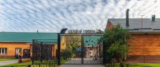
The works of Pushkin, Derzhavin, Aksakov, Krylov, Tolstoy, Shevchenko, Korolenko and Dahl are associated with the Orenburg region. Here the names of Yuri Gagarin, Lyudmila Petrova, Irina Safarova, and the Dobroskok brothers are woven into the history of the region.
However, when mentioning the region first, an association with the Orenburg downy scarf always arises. The down knitting craft originated here in the 18th century, and world fame came to it after the 1857 exhibition in Paris. Today, the owners of the product are singers Fergie, Madonna and Montserrat Caballe, actresses Annie Girardot and Sean Young and many others.
Its special feature is the down of local goats, which is considered the thinnest and most durable in the world. But working with it requires unique skills: craftswomen spend about a month making one large scarf.
For ease of route planning, we have marked all mentioned cities and attractions on the map of the region:
What to see in the Orenburg region
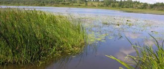
Five attractions claim to be the main symbols of the region: two vast nature reserves, the largest river in the region, the unusual Camel rock and the Luna landscape park.
Orenburg Reserve
- Coordinates on the map: 51.085556, 57.686944.
The largest reserve in the Orenburg region covers an area of more than 38,000 hectares. The idea of creating a natural reserve appeared in the 20s of the last century, but it was realized only in 1989.
Scientists who advocated the organization of the reserve pursued a single goal - to preserve the unique steppe landscapes of the Volga region, the Cis-Ural region, the South of the Ural Mountains and the Trans-Ural region. In 2015, the area of the protected zone almost doubled.
The structure of the reserve is also unique: it consists of five separate sections scattered throughout the region. The smallest area - “Talovskaya Steppe” - is located in the extreme western point of the region, on the border of the Pervomaisky district and the Samara region.
The largest – “Pre-Ural Steppe” – took place in the center, in the Belyavsky and Akbulaksky districts. Nearby, a few kilometers from each other, are located the “Burtinskaya steppe” and the “Aytuarskaya steppe”. The last section, “Ashchisay Steppe,” is located near the eastern border.
90% of the entire protected area is occupied by steppes, where 1,350 plant species grow, including endangered species and endemics. The fauna is also diverse; the protected lands are inhabited by steppe harrier, steppe marmot, badger, black grouse, small gopher, long-eared hedgehog, elk, roe deer and many other species of mammals and birds.
In 2015, scientists released a group of Przewalski's horses onto one of the sites. The Orenburg Nature Reserve is of interest not only to biologists, but also to historians, as priceless archaeological monuments of Sarmatian culture have been found here.
Reserve "Shaitan-Tau"
- GPS coordinates: 51.649115, 57.399937.
A small reserve in the Kuvandyk district was formed quite recently - in 2014. The young reserve included the Shaitanau ridge and surrounding lands, the total area of the protected territory is more than 6,700 hectares.
The perfectly preserved oak forest-steppe is home to hundreds of animal species, many of which are listed in the Red Book of Russia. The beautiful Sakmara River flows through the reserve, into which dozens of smaller rivers and streams flow.
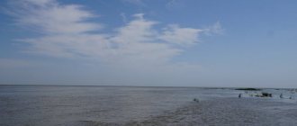
Ural River
- Coordinates: 51.732988, 55.641325.
The Ural is a waterway connecting Russia and Kazakhstan. In terms of length, it is second only to two European rivers - the Volga and Danube. The river received its modern name in 1775; previously it was called Yaik, which means “wide”. It is easy to guess that the Urals originate in the Ural Mountains, and specifically on the Uraltau ridge in the Republic of Bashkortostan.
Wriggling like a huge shiny snake, the river “crawls” into the Chelyabinsk region, then penetrates the Orenburg region, crosses it from east to southwest, flows into Kazakhstan and flows into the Caspian Sea. The Urals are rich in fish; sturgeon, carp, pike perch, stellate sturgeon, catfish, and perch live in its waters.
Rock Camel
- Coordinates: 51.380297, 61.384880.
An unusual landmark on the banks of the Ashesu River, on the eastern border of the region, has become one of the most recognizable symbols of the region. The small rock bears a striking resemblance to a lying camel.
Nature itself created an amazing sculpture from two quartzite blocks: one looks like a body with a hump, the second looks like a long neck and head with a protruding nose. The height of the stone beast is 14 meters; tourists love to climb onto its high back. The colorful figure appeared on the flag and coat of arms of the Svetlinsky district.
Landscape Park "Luna"
- Coordinates: 53.067433, 54.541393.
In the Sharlyk district of the Orenburg region, near the banks of the Dema River, in the tiny settlement of Luna there is a landscape park of the same name, which many tourists call the most heavenly corner of the Orenburg region.
On the territory of this attraction you can find beautiful sculptures that look like they came out of a fairy tale, a picturesque pond with the opportunity to sail on it on a catamaran or boat, and a colorful cafe where the food is very tasty.
There is also a real open-air zoo here - it consists mainly of deer walking around the territory, which you can even pet, and swans gracefully swimming in the lake, complementing the harmonious composition of the place.
State reserve
The Orenburg region, whose nature is famous for its beautiful landscapes, reservoirs and unique flora and fauna, is a favorite holiday destination among tourists from many countries of Eastern Europe. There are several protected areas in this region.
The Orenburg State Reserve is the largest reserve in the steppe regions of the Southern Urals and Trans-Volga region. The protected area includes 4 sections. Let's take a closer look at these natural monuments of the Orenburg region.
The most famous mountains and hills of the region
The Orenburg region covers the southern tip of the Urals, a significant part of the region is occupied by majestic mountain peaks. The picturesque Orenburg ridges inspired Alexander Pushkin while writing the story “The Captain's Daughter”.
Kuvandyk Mountains
- Coordinates: 51.505801, 57.351992.
The mountains of the Kuvandyk region are called “Orenburg Switzerland” for their beauty and resorts. The Kuvandyk 365 ski complex operates on the slopes of the mountain range. There are several trails on the mountains, and there are two tow ropeways. There is convenient parking and a small cozy cafe on site. Competitions among amateur skiers are periodically held in the Kuvandyk Mountains.
Shaitantau mountain range
- Coordinates: 51.580146, 57.419711.
Amazing peaks on the border of the Orenburg region and Bashkortostan are part of the Southern Urals. The name of the ridge translated from Turkic means “Devil’s Mountain”.
It is believed that the mountains received such a “flattering” name for the dense impassable forests on the slopes, in which travelers often got lost. The total length of the ridge is 45 kilometers, width is 15 kilometers. The largest peak reaches 620 meters in height.
In the Orenburg region there is only a small part of the massif, all of it falls on the territory of the Kuvandyk region. Shaitanau has a great variety of minerals and valuable fossils. Limestones about 500 million years old are hidden in the depths of the mountains, as well as the remains of fossil sea animals and algae.
The surroundings of the ridge are inhabited by taiga and steppe animals and birds: brown bear, wild boar, squirrel, gopher, bobak, peregrine falcon, golden eagle and even turtles.
Guberlinskie Mountains
- Coordinates: 51.221642, 57.818350.
Another mountain range of the Southern Urals stretches from north to south in the eastern part of the region. The length is 70 kilometers, the highest peak is Mount Poperechnaya. The mountains got their name from the Guberlya River flowing nearby; the massif is cut by its tributaries, so there are many picturesque ravines and gorges in the mountains.
Rich deposits of copper, chromium, nickel, limestone, manganese, iron and other minerals were found in the massif.
Nagai and Dolgiye mountains
- Coordinates: 51.638140, 56.395896.
The narrow mountain range occupies the territory between the Sakmara and Ural rivers. The border between the Nagai and Dolghi mountains can be easily determined by the largest peak, 414 meters high.
The southern point of the Long Mountains is the picturesque Mount Camel, which looks like a gigantic camel. The hills are densely overgrown with yellowish steppe grasses; occasionally, shrubs and coniferous trees are found at the foot.
In spring, the mountains briefly turn bright colors: red-listed irises, Bieberstein tulips and open urchins bloom on the slopes. In the warm season, it is especially crowded here: the ridge is chosen by paragliders and fans of multi-day hikes.
Chesnokovsky chalk mountains
- Coordinates: 51.695586, 54.022322.
4 kilometers from the village of Chesnokovka there are white limestone hills. The Cretaceous Mountains are more than 70 million years old; the peaks grew from the bones of animals that lived on the bottom of the ancient ocean. The snow-white slopes are dotted with the remains of prehistoric mollusks - belemnites and ammonites.
Fossils lie right under your feet, and among them, endangered plant species such as chalk toadflax and chalk daisy make their way to the sun. Snakes, lizards and various steppe rodents are busy in the white dust. Above the peaks, eagles can be seen from time to time, soaring above the ground in search of prey.
Mount Colonel
- Coordinates: 51.154020, 58.652674.
Low, only 236 meters, Mount Colonel is not popular among lovers of rock climbing and mountaineering. But it is perfect for a weekend walk, as it offers wonderful views that even children can reach. The hill is also famous for the fact that on its top and along the slopes you can find jasper, which will be a wonderful souvenir from the hike.
The most beautiful places in the Orenburg region
The Orenburg region is truly a fabulous land. It's hard to imagine another region with as many stunning landscapes. The stunning landscapes of the Orenburg region are the fruits of centuries-old creativity of natural elements.
Red steep
- Coordinates: 51.476338, 54.201187.
Red steep is a fantastically beautiful cliff on the shore of the Dmitrovsky, or Chernovsky, reservoir. The spectacular attraction is located 12 kilometers from the village of Krasnokholm. The 15-meter hill is made of brown-red sandstones, and therefore has a very bright color and is visible from afar.
What makes the steep slope unique is not only its color, but also its unusual shape: water has eroded the foot of the slope and turned it into a bizarre sandy gallery with many niches, arches and columns. The wind sculptor contributed and turned the red protrusions into original turrets. Krasnaya Krucha is recognized as a geological natural monument.
Bukobai Yars
- Coordinates: 51.441629, 55.448880.
The cliffs on the banks of the Bukobay River are distinguished by some special, alien beauty. Three areas with a total area of 136 hectares are occupied by unique spherical rocks. Round boulders on legs resemble huge mushrooms or snake heads.
Yellowish sandstones began to take shape millions of years ago, when dinosaurs walked through the territory of the modern Orenburg region.
The age of the stone figures is evidenced by the finds of archaeologists and paleontologists - fossilized plants and bones of mastodonsaurs of the Mesozoic era. Strange sculptures are the result of centuries of weathering. The yars have the status of a natural monument.
Buzuluksky pine forest
- Coordinates: 52.941468, 52.031265.
The extensive national park is located on the lands of two neighboring regions - Samara and Orenburg - but was formed precisely in the Orenburg region. The Orenburg part falls on the territory of the Buguruslan and Buzuluk districts. The name of the pine forest comes from the latter area, and it is there, in the village of Koltubanovsky, where the administration and museum of the park operate.
The most valuable area of the national park is a unique pine forest near the city of Buzuluk. Scientists have determined that the boron was formed after the Ice Age and is at least 6,000 years old.
It is difficult to imagine how many generations of trees have changed over such a long period of time. The oldest inhabitants of the forest are two pines, whose age has exceeded 300 years. The pine forest is surrounded by deciduous trees and steppes, and the area is inhabited by typical forest animals, birds and insects.
Kzyladyr karst field
- Coordinates: 51.196964, 56.897127.
The extensive landscape and geological monument is one of the most impressive attractions of the Kuvandyk region. On a piece of land about 12 kilometers long, mountain ranges stretch, cut by wide and deep hollows, karst sinkholes and caves.
Underground lakes are hidden in some grottoes, and birds nest in others. On the hills, barely covered with low steppe grass, lie large pieces of multi-colored gypsum and petrified calamite trees.
Kamsak Gorge
- Coordinates: 50.878838, 59.365564.
In the steppes of the Dombarovsky region there is a beautiful rocky gorge created by the persistent Kamsak river. The low right bank of the river is overgrown with greenery, and on the left side of the water flow 10-meter rock pillars rise.
Due to inclusions of various minerals, the wall has a greenish-white color. In the gorge there is a small cave in which, according to legend, a hermit monk lived.
Buzuluksky pine forest
The nature of the Orenburg region, photos of which are presented in the article, impresses with its uniqueness and beauty. This is confirmed by the Buzuluksky forest. This huge forest area is located in the Orenburg and Samara regions. City dwellers love to relax in this amazing place. After all, this is where you can forget about the bustle of the city and enjoy the most beautiful nature.
Most of the territory of the Buzuluksky forest is occupied by grass and mossy pine forests. Rare trees, shrubs and herbs grow here.
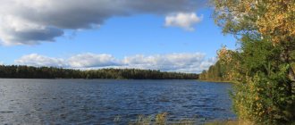
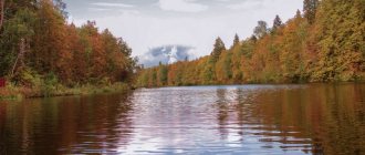
Reservoirs and lakes of the Orenburg region
On the territory of the Orenburg region there are many salt and freshwater reservoirs of both natural and artificial origin.
Lake Razval
- Coordinates: 51.149670, 55.001213.
A small salt lake in the city of Sol-Iletsk appeared in an old salt quarry. Centuries ago, Mount Tuz-Tyube rose here, which translated from Kazakh means “Salt Mountain”. In the middle of the 18th century, the industrial development of the salt dome began, and after 150 years, a deep hole with a diameter of about 250 meters gaped in the place of the hill.
In 1906, the Peschanka River flooded the quarry, creating a beautiful lake with medicinal brine. In 1979, the reservoir disappeared, but a few years later it filled up again.
The concentration of salt in the water is so high that the lake does not freeze even in the most severe frosts. The collapse is often compared to the Dead Sea: there are also no plants or living organisms in the Orenburg reservoir. The fame of the healing waters and mud of the lake spread far beyond the region; in 2010, a healing and recreational area was organized on its territory.
Lake Shalkar-Ega-Kara
- Coordinates: 50.750370, 60.887639.
The largest reservoir of natural origin in the region is located in the Svetlinsky district near the border with Kazakhstan. The mineralized lake has an almost regular round shape, its length is 10 kilometers, width is 11 kilometers.
The reservoir is drainless and very shallow, the average depth is only 1 meter. Due to its characteristics, Shalkar-Ega-Kara completely dries out every 10 years and freezes to the bottom almost every winter. Only in early spring, during the flood period, does the lake connect with the Buruktal River.
If the connection between them lasts long enough, then roach, carp, perch, ide and other representatives of the ichthyofauna enter the pond poor in fish. The rest of the time, the lake is inhabited only by crucian carp, which are hunted by gull-billed terns nesting on the shores.
Lake Zhetykol
- Coordinates: 51.041227, 60.896793.
The second largest Orenburg lake lies in the Svetlinsky district. The name of the reservoir is Kazakh; it is translated into Russian as “seven lakes.” Zhetykol has no drainage, its waters are saturated with salts, and the average depth does not exceed 1.5 meters.
The reservoir is surrounded on all sides by hills on which migratory waterfowl nest. On one of the banks is the village of Ozerny.
Iriklinskoye Reservoir
- Coordinates: 51.779166, 58.772991.
The largest artificial reservoir in the region and the entire Southern Urals was created in 1966 on the Ural River. The reservoir was filled after the construction of a dam at a hydroelectric power station in the village of Iriklinsky. After the completion of large-scale work, the length of the reservoir was 70 kilometers and the width was 8 kilometers.
The new reservoir was supposed to supply water to industrial enterprises and populated areas. In order to create such a huge reservoir, residents of 22 villages, villages and towns had to be resettled from the Iriklinskaya Valley.
Sorochinskoye Reservoir
- Coordinates: 52.400056, 53.252640.
Another famous reservoir is located near the city of Sorochinsk. In size, Sorochinskoye is inferior to the Iriklinsky reservoir, its length is about 28 kilometers, width is 4 kilometers.
The reservoir was formed on the Bolshoi Uran and Samara rivers in 1997. Construction of the reservoir began much earlier - in 1976, but the project was frozen due to financial difficulties. The contractors managed to continue the work only 20 years later; all the objects were finally commissioned only in 2009.
At the moment, recreation areas have been organized on the shores, beaches have been equipped, but there is not a single tourist center. The reservoir is popular with fishermen and outdoor enthusiasts.
Unfortunately, the reservoir cannot be called environmentally friendly; the coast is polluted with garbage, which is why swimming is prohibited in many places. Nevertheless, pike, perch, carp, pike perch and other species of fish live in the water, and in the summer beautiful white swans fly to the Sorochinsky coast.
Cities and villages
Orenburg
They say about Orenburg that it is a thrice-conceived and once-born city. The fact is that the first two places that were chosen for the foundation of the settlement turned out to be unsuccessful. The city stands on the banks of the Ori River, which at one time determined its name.
True, during Soviet times he was called Chkalov in honor of the test pilot. There is even a six-meter statue of him in the city. Only Valery Pavlovich himself has never been to Orenburg.
Local buildings amaze with their architectural diversity. Among them there is even a medieval castle. It is also worth taking a look at St. Nicholas Cathedral, which is the only one in all of Orenburg that survived the Bolshevik era. There is also something for young tourists to do - they can ride along the 6-kilometer children's railway.
- “National Village” is a pedestrian street where traditional dwellings of Kazakhs, Bashkirs, Russians and other residents of the Orenburg region coexist. Here you can get acquainted with the life and cuisine of each nationality.
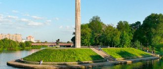
- The pedestrian bridge over the Ural River is a bridge connecting parts of Orenburg, and at the same time Europe with Asia. During an intercontinental walk, you will be reminded of the invisible border by the symbolic border pillars installed here.
- , the Elizabeth Gate was the meeting point between Europe and Asia, and today it is a symbolic place for lovers. Those who want to live a happy married life come here to take photos.
- The Orenburg Fortress is known to everyone who has read “The Captain’s Daughter” by A. S. Pushkin. The writer came here in 1833 to obtain material for his work. By the way, his guide was V.I. Dal. Only parts of the structure that witnessed Pugachev’s uprising have survived to this day.
- The clock tower adorns one of the central streets of the city. Every day at 12:00 and 17:00 the chimes ring here. At the same time, various melodies are played, including “Orenburg Shawl”, “Farewell of the Slav” and the city anthem. And from the windows of the clock various characters connected with the history of Orenburg look out: Pushkin, Shevchenko, Pugachev, a craftswoman with a scarf, a soldier, etc.
More interesting things about Orenburg and its attractions.
Sol-Iletsk
Sol-Iletsk is a salt-packing city that supplies all of Russia and part of the world with its products. A place where one of the attractions is a pink building with dolphins at the entrance, which is called “Black Dolphin” and is a prison for especially dangerous criminals.
This is the city that saved the country from a watermelon shortage in 2007. A place where any tourist can get dirty with mud, lie in salt water and swim in fresh water in a couple of hours.
- Lake Razval is like the younger brother of the Dead Sea: just as lifeless and unusual. This is 7 hectares of healing water: tourists and locals say that it cures skin diseases, asthma and osteochondrosis.
- Lakes Tuzluchnoe and Dinino. People come to these ponds for black healing mud , which helps get rid of diseases of bones and tendons, nervous disorders and rheumatism, ulcers and scars, and also improves immunity.
- Bukobay yars are spherical natural sculptures with a diameter of about 70 cm. They are said to have a special energy. Whole groups come here to meditate. Here you can also see a tectonic fault 10 meters deep.
Springs and waterfalls of the Orenburg region
The Orenburg land is fed by dozens of springs. Local mineral and hydrogen sulfide springs are of great importance for health tourism, and the especially revered consecrated springs attract hundreds of pilgrims.
Hanging springs of Rodnikovka
- Coordinates: 53.982143, 53.491824.
In the vicinity of the village of Nikolkino you can see unusual springs. Countless water springs make their way out of the steep slope of a high red hill and run down in cheerful streams into the Rodnikovka River.
Other streams fall from the steep wall and form small waterfalls. In some places, water flows have washed out small niches in the mountainous banks.
Kondurovsky hydrogen sulfide spring
- Address: s. Kondurovka, Saraktashsky district.
The cold spring near the village of Kondurovka has healing properties due to its high content of hydrogen sulfide. Water has an unpleasant taste and smell, but helps in the treatment of many diseases.
The spring comes out at the foot of the hill, the area around it is practically undeveloped. In 2011, believers consecrated the spring in honor of the icon of the Mother of God “Quick to Hear” and erected a wooden cross of worship next to the stream.
Dmitrievsky hydrogen sulfide spring
- Coordinates: 53.382083, 54.155889.
Another famous hydrogen sulfide mineral spring is located near the village of Dmitrievka, Ponomarevsky district. The spring forms a small round lake with amazingly clear blue water. Local residents surrounded the pond with a fence and organized several descents into the water.
The source remains cold even in hot weather, but neither the temperature nor the specific smell stops tourists who want to take healing baths. Swimming in the lake is good for health, but you must remember the contraindications: for some diseases, such a procedure can only cause harm.
Spring "Kainar"
- Coordinates: 51.229194, 56.671694.
The Belyaevsky district is famous for its springs, perhaps the most visited of them is the mineral spring on the territory of the Burtinskaya Steppe nature reserve. The Turkic name “Kainar” is translated into Russian as “source”.
Mineral water hardly heats up in summer and does not freeze in winter. A stream of the same name flows from the spring, which forms a tiny round pond. Several years ago, the lake was surrounded by wooden sides, and a neat gazebo for relaxation appeared nearby.
"Holy Key"
- Coordinates: 53.441246, 53.311949.
In a gully 5 kilometers from the village of Kuzkino there flows a revered holy spring. The key is located away from the roads, with endless fields stretching around it. The spring is well equipped; it is enclosed in a concrete well, over which a small wooden chapel is erected. The water in the holy spring is always cool and remains fresh for a long time; some believers consider it healing.
The key is sometimes called “Revealed”, as there are legends that saints have appeared in the beam more than once. The spring has been known for more than a hundred years; even in Soviet atheistic times, pilgrims from all over the Orenburg region and neighboring regions came to it. In 1998, the spring was recognized as a hydrological natural monument of regional significance.
Springs village Kiryushkino
- Coordinates: 53.560993, 52.288036.
The springs in the village of Kiryushkino, Buguruslanovsky district, are also considered sacred, but they are revered not by Christians, but by pagan Erzya. The three springs were nicknamed “Vishka Lisma”, “Poksh Lisma” and “Baban Kasha”.
The last source is especially important; its name translated from Erzya means “Babya porridge” - a ritual dish for a pagan holiday. The Erzya used spring water to treat diseases and protect against evil spirits; they sprinkled it on their homes, outbuildings, people and livestock.
Today, residents of surrounding villages still come to the source. A small wooden house is erected above the spring, and life-giving moisture is supplied through a metal pipe.
Silver Spring
- Coordinates: 52.569546, 56.102710.
It is also a fairly well-known spring in the region, where hundreds of vacationers flock. It is located in the Tyulgansky district, near the village of Tugustemir. There is a place to relax next to the source where you can barbecue. The spring water itself here is very cold, icy and, according to unverified sources, it actually contains silver.
Burtinskaya steppe
The protected areas and nature of the Orenburg region are what this amazing region is famous for. The Burtin steppe is a beautiful region, the pride of local residents. This section of the state reserve is located between the Ural and Ilek rivers. This territory is home to such rare fauna as little bustard, steppe eagle, buzzard, lapwing, etc.
The Burtinskaya steppe is a place where the most beautiful and unique natural objects of the Orenburg region are located.
- The Tuzkaragal tract occupies the central part of the reserve.
- The Kainar spring is a powerful healing source, the water in which does not freeze even in the most severe winter.
- Carmen Hills - unique shrub and rocky steppes are preserved in this area.
- Lake Koskol is a real pearl of the Urals. These are unique reservoirs of karst origin. Situated in the upper reaches of the Tuzlukolli River.
- The turtle swamp is the only habitat of the marsh turtle on the territory of the Orenburg Nature Reserve.
- Sarmatian burial mound of the 7th-3rd centuries. BC e.
Monuments of archeology and paleontology
Orenburg ancient monuments are surprisingly numerous and diverse. Almost the entire territory of the region is dotted with the remains of extinct sea and land animals, and in some corners traces of the first human settlements have survived.
Mount Zmeinaya
- Coordinates: 51.421192, 55.404053.
A small mountain near the village of Belyaevka is not just another peak of the Southern Urals, but a most valuable monument of paleontology. Previously, there were many reptiles in the short grass on the slopes of the hill, so the mountain was dubbed Zmeinaya, although some Orenburg residents call it Khanskaya, or Khanova.
The steep slope is made of giant multi-colored slabs, in which ancient marine animals of the Jurassic period are forever frozen. The mountain has preserved so much diverse fossil fauna that research continues to this day.
Among the fairly common fossils like belemnites and ammonites, there are also rarer ones, for example, the bones of the sea lizard plesiosaur. At the suggestion of scientists, the state took the territory under its protection in order to preserve the precious finds.
Cemetery of pseudo-crocodiles
- Coordinates: 51.593391, 53.647579.
On the outskirts of the village of Rassypnoye there is a deep ravine called Mayachnaya. The slopes of the ravine are fraught with many surprises. At first glance, this is an ordinary hill, but in fact it is a cemetery of ancient animals. Millions of years ago, lakes splashed in its place, in which all kinds of amphibians and reptiles swam. It was here that paleontologists discovered the remains of pseudosuchia, or pseudocrocodiles - the most ancient ancestors of dinosaurs.
These extinct animals resembled large crocodiles; they were distinguished from their descendants by longer vertical limbs. Pseudosuchians moved on land not by crawling, like modern reptiles, but on outstretched legs, like dogs. Bones and even entire skeletons of fossil creatures have been preserved in Rassypnoye. Among the finds is the skull of a labyrinthodont, a lizard-like amphibian from the Mesozoic era.
Åland settlement
- Coordinates: 52.197000, 59.885117.
The existence of traces of an ancient city in the Kvarken region might not have been known if not for a happy accident. In 1987, specialists from Uralaerogeodesy carried out aerial photography in this area. Later, office employee A.E. Puchin, looking at the photographs, drew attention to a strange circle between the Suunduk and Solonchak rivers. Chelyabinsk archaeologists were informed about the curious find, and within a few months the first expedition to the ancient settlement was organized.
Archaeologists planned to carry out excavations, but soon the collapse of the USSR occurred, difficult times came for the whole country, and practically no money was allocated for science. I had to forget about a full-fledged study of the settlement.
The first excavations took place only at the beginning of the 2000s. Experts have established that the Åland settlement arose approximately 4,000 years ago; it was part of the “Country of Cities” system and was similar to the famous Arkaim. Dozens of artifacts have been preserved in the ground, such as tools made of stone, bone and bronze, fragments of pottery, as well as defensive ramparts, ruins of a stone fortress wall and ruins of dwellings.
Estate S.T. Aksakova
For lovers of Russian literature, our company offers a tour to the picturesque Russian village of Aksakovo, whose name was given in honor of the author of the well-known fairy tale “The Scarlet Flower”. Travelers will be shown the writer's estate and house. Since the time of Sergei Aksakov’s life, practically nothing has changed there - all the same centuries-old linden trees and old pond, picturesque hills and a romantic park. At the end of the mandatory program, participants are given free time to relax (they can take photographs).
The excursion takes one day (departure early in the morning, return to Orenburg late in the evening). Lunch is included in the tour price.
The most beautiful Orenburg caves
The Orenburg region has prepared pleasant surprises for speleologists: in the local mountains there are several caves accessible to travelers. Many of the grottoes have a complex structure, so tourists should take care of their safety before visiting them.
Cave Gift
- Coordinates: 51.456516, 56.597183.
The largest gypsum cave in the region is located in a mountain near the village of Dubensky. The length of the underground labyrinth is 660 meters. “The Gift” consists of several rooms and three levels, the entrance is located at the top. In some places you can come across stalactites and stalagmites.
The halls are always cool; in summer the temperature stays at around 12°C. Visitors to the cave must have suitable equipment: helmet, warm clothing, flashlight. It is safer to travel through the tunnels accompanied by an experienced guide.
Yumaguzinskaya cave
- Coordinates: 51.605182, 57.607272.
The most famous cave in the Orenburg region is hidden in the depths of Mount Beloshapka, located near the village of Yumaguzin. Being at the foot of the mountain, it is difficult to notice the low entrance, buried in thickets of tall grass. Those brave souls who decide to make their way through the inconvenient underground corridor will be rewarded - a spacious hall with ancient fossilized plants and animals on the walls.
Cave "Mosaic"
- Coordinates: 51.375222, 57.090065.
“Mosaic” is one of the many gypsum caves of the Kzyladyr field. Getting into it is not easy: the entrance is low, in winter the underground corridors and rooms freeze, and in the spring they are filled with floods. Tourists usually visit the grotto in dry weather in the summer.
There are beautiful stains on the walls of the cave, and in places there are small stalactites and stalagmites. Amateur speleologists need to wear a helmet to avoid injuring their heads on sharp protrusions, and warm clothing, since the temperature inside does not rise above 14 °C even in the heat.
Holy Caves
- Coordinates: 51.997561, 53.893381.
The caves in the village of Pokrovka have a long history. At the end of the 19th century, Orsky Cossack Zakhary Kartsev settled here, on the banks of the Samara River. The hermit dug a cave for himself, improved the spring that babbled nearby, and spent all his days in fasting, labor and prayer.
People who thirsted for spiritual achievements and salvation were drawn to the righteous man. They also dug caves and settled near Zechariah. Gradually, a community of Christians leading a monastic lifestyle emerged. Over time, the monastery received official status, and Zachary took monastic vows with the name Zosima. Cells and a temple were built in the caves, then the brethren began to build buildings on the surface of the earth.
After the October Revolution, the monastery was closed, and the above-ground buildings were dismantled into bricks. In the 90s, monasticism in Pokrovka began to revive, believers restored the buildings, but the entrance to the caves was found only in 2002.
Today, the grottoes again enter the boundaries of the St. Nicholas Convent; you can get into the dungeon through the Church of the Nativity of John the Baptist. The cold, cramped cells are filled with icons and candles. The nuns themselves conduct tours of the holy caves and talk about the history of the monastery.
You may also be interested in interesting places in individual cities of the Orenburg region - Orsk and Orenburg
"Saraktash miracle"
The village of Saraktash includes several natural and historical attractions. It is here that a wonderful view of the tip of the Ural Mountains opens up, the Holy Trinity Monastery and Red Mountain are located.
The spiritual monastery was built in Soviet times; it is distinguished by its unusual architecture, which is not entirely characteristic of the image of an Orthodox building. And on a high hill called Red Mountain there is a real Russian fortress, which annually attracts many tourists. The building was erected for the filming of the film “Russian Revolt”.
A guided tour of the region will take 5 hours. It is recommended to bring comfortable shoes and headscarves for women to visit the temple.
Orenburg region: unique examples of architecture
In the vast expanses of Orenburg there are also architectural delights that often end up in the photo albums of travelers who come here.
German places near Mednogorsk
Photo: © https://yandex.ua/maps/-/CCUaBUDg-C
- Coordinates: 51.402793, 57.669641.
A little east of the city of Mednogorsk lies the large German Bridge, built during the Austro-Hungarian Empire. The place is very mysterious, enigmatic and colorful, which can be seen even from the photo.
Trinity Simeon Convent of Mercy
- Address: st. Pushkina, 77, Saraktash village.
In the city of Saraktash there is probably the most popular and famous monastery in the entire region. In addition to the fact that everything here is imbued with centuries-old holiness, many note the presence of a special, sincere atmosphere created by the ministers. And the buildings of the monastery, as well as its territory, are a real architectural and landscape masterpiece.
Timashev Estate
- Address: Tyulgansky district, Tashla village.
But this exquisite architecture, unfortunately, has been almost completely destroyed. However, this prevents guests from coming here and admiring the walls and tall arches of the once majestic estate of the Timashev nobles. The date of construction of this unique place for the Orenburg region is 1767. It is surrounded by a beautiful park, which has also fallen into disrepair.
Catherine Bridge (Katkin Bridge)
- Coordinates: 51.724725, 54.311108.
Another interesting bridge can be found north of the village of Tatishchevo. True, the Catherine Bridge, which is also called Katkin, does not fulfill its function and is in a dilapidated state.
Don't miss the sights of the regions neighboring the Orenburg region - Chelyabinsk, Saratov and Samara regions, as well as Tatarstan and Bashkortostan
All of the listed attractions are just a small part of the beauty of the Orenburg region. The magnificent landscapes of this picturesque region deserve the loudest epithets, and traveling through it promises a lot of pleasant impressions.
Churches, cathedrals and temples
Orthodox Saraktash Convent of Mercy
Address: Saraktash village, st. Pushkina, 77 Phone: 8 (35333) 6-12-32 and Website: stobitel.ru Cost: children - 50 rubles, adults - 100 rubles. per excursion Opening hours: excursions by arrangement
The Saraktash monastery is called the Vatican of the Orenburg region. The largest Orthodox complex in Russia was founded in 1990 on the basis of the Intercession parish. That year was special for this place.
- The icon of the Mother of God was updated: printed at the end of the 19th century, the image darkened so much that the outlines of the Mother and Jesus became indistinguishable. Then it was decided to replace it. But a miracle happened: a few days later the faces of the saints brightened. And then gradually the whole icon.
- After long negotiations, the building of the former Church of Semeon of Verkhoturye, where the kindergarten was located, was returned to the church.
- A young priest, Nikolai Stremsky, arrived in Saraktash. At that time the monastery owned only a small prayer house.
By the way, Nikolai’s father’s family is the largest in Russia. He has 72 adopted children.
Holy Tikhvin Mother of God Convent (Buzuluk)
Address: Buzuluk, st. Sergo, 1 Phone: 8 (35342) 2-33-15 Website: buzulukjenmonastyr.prihod.ru
“The chosen vessel,” said the great elder Seraphim when he saw the peasant girl Euphemia Ovsyannikov. After such a blessing, she dedicated herself to the Lord and founded a women's community, which later received the status of a monastery.
During the years of Soviet power, its churches were used as a power plant and warehouses. The cells turned into cells of a transit prison, where prisoners were tortured and shot. In one of them, the locally revered schemamonk Maxim suffered martyrdom.
After the Great Patriotic War, the monastery began to be revived: the All Saints Church was opened. In 2000, it was transformed into the Tikhvin Convent.
Catherine's Church in Tugustemir
Address: s. Tugustemir, st. Tserkovnaya, 5
The Church of the Great Martyr Catherine was built by titular councilor Viktor Zvenigorodsky in memory of his wife, who died of consumption. Bricks for construction were made three kilometers from the future temple in a neighboring village.
According to legend, they were delivered to the construction site in an unusual way: they were passed along a chain from hand to hand.
The facade of the temple was decorated with 12 plaster apostles. A bell tower 43 meters high was built nearby. During the Soviet period, the temple was closed and partially destroyed.
To date, restoration work has not been completed.
Church of the Transfiguration of the Lord in Orsk
Address: Orsk, st. Stepana Razina, 100a Phone: 8 (35372) 6-60-51 Website: prihod.orsk-net.ru Opening hours: Mon-Sun 07:00-19:00
The temple has changed 3 locations throughout its history. It was moved twice due to floods until it was built on the mountain. But even here he did not stand for long - there was a fire. The building was restored, but this time made of stone.
Construction was timed to coincide with the visit of Nicholas II. The temple was created as a symbol reminiscent of this event.
But in 1934 it was dismantled, leaving only the bell tower, which was used for the needs of firefighters. It was revived in 1993.
Temple of the Archangel Michael
Address: s. Gorodishche Phone: Website: gorodische-orenburg.prihod.ru
The history of the temple begins with the construction of a wooden church in 1836, but it did not stand for 50 years - it burned down. In 1880, a new stone building was laid.
The whole village built, bricks were delivered to the construction site by hand. Young people even brought them to the future temple before the festivities. In Soviet times there was a grain storage facility, a tractor repair shop and warehouses.
- Here is the miraculous icon of the Most Holy Theotokos “Quick to Hear.”
- The temple contains the relics of Mary Magdalene, the Great Martyr Panteleimon, St. Seraphim of Sarov and many others.
If you have not yet chosen where you will live and want to save money when booking, we recommend using the RoomGuru service. Firstly, it contains hotels, apartments and guest houses from many different booking systems, so you won’t miss out on a worthwhile option. Secondly, you can immediately compare prices for one place in different services and book where it is cheaper (this is not always Booking!).