Vyatka, as the Kirov region is often called, is one of the most cozy provincial regions of Russia. There are ancient settlements, Orthodox shrines, and magical lakes here. Local residents are still engaged in folk crafts today, covering toys with the famous Dymkovo painting and carving nesting dolls, weaving bast shoes and composing legends about mysterious places. And the natural attractions of the Kirov region cause genuine delight and surprise, because such wonderful places as on Vyatka land are still worth finding.
Where to visit in the Kirov region
Sometimes attractions can tell a better story about a region than its inhabitants. There are such places in the Kirov region.
Nurgush Nature Reserve
- Coordinates on the map: 58.020964, 48.446023.
A specially protected area of federal significance was created in 1994. It consists of two sections. Nurgush - in the Kotelnichsky district - is engaged in the protection of floodplain forests. Tushalor - in the Nagorsky district - an old-growth tract of spruce and mixed forest. Several eco-trails have been organized for visitors to the protected area:
- "In Search of Mystery"
- "The Yeti Trail"
- "Hello, beaver"
- "Hare Glade".
On these routes you have the opportunity to get a closer look at the inhabitants of the reserve, such as beavers, osprey, raccoon dogs, muskrats, etc. There is also a natural science museum. Among its exhibits are objects made of various types of wood, medicinal herbs, and ancient fishing gear.
Rock massif Stone
- GPS coordinates: 57.428887, 48.948001.
The rocks on the bank of Nemda, similar to fortress walls, are part of the Chimbulat botanical-geological complex. They are composed of limestones that formed back in the Permian period. Nemda washed out and laid its channel through them.
Thanks to this, today it is possible to admire the bizarre cliffs and grottoes, steep walls and caves. The calling card of the massif is the Chasovaya stone outcrop, 8 m high. Tourists especially love it. Climbers often gather here for training and competitions.
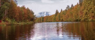
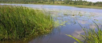
Lake Shaitan
- Coordinates: 57.096172, 49.462219.
The lake in the Urzhum region is a natural monument and is part of the Bushkovsky Forest reserve. Due to the siphon circulation of groundwater, sometimes it is released to the surface. Therefore, the reservoir was once called Shaitan Lake.
Local residents believed that this was the home of an evil spirit who threw out fountains of water when he was angry. They never swam or fished in the lake.
Water releases most often occur in the spring. In this case, floating islands covered with vegetation are formed on the surface of the reservoir. Their number can reach 20 pieces. Some of the raftings have names, and legends are made about their appearance.
Yezhovsky lake and spring complex
- Coordinates: 58.591619, 49.690516.
A unique lake in the historical center of Kirov is called Yezhovsky Pond. It is located between the banks of the river. Vyatka and the railway embankment, parallel to the river. Khlynovka.
This is the only reservoir in the city with spring water, because it is fed by 20 springs flowing from Kikimorskaya Mountain (the coastal cliff of Vyatka). Today this little-known landmark has the status of a hydrological natural monument of regional significance.
Nemda River
- Coordinates: 57.165403, 48.947592.
The river belongs to the Kama basin and flows through two districts of the Kirov region - Nemsky and Urzhumsky. Its length is 96 km, the source is located in the Krasnovo tract, a few km from the village of Nema.
She made her way among the limestone rocks, so both the shore and the riverbed are intricately indented. The most interesting places are located in the area of the Chimbulat botanical-geological complex. For its magnificent nature, mountain landscape and fresh air, tourists call this area Kirov Switzerland.
Suvodsky Bor (Sovetsky district)
The picturesque pine forest, located on the left bank of the Vyatka River, lies on sandy hills - ancient dunes formed more than a hundred thousand years ago. Giant larch grows in the forest, which is more than 300 years old. Height 39 m, diameter – 84 cm.
location of the remains of ancient animals (pareiasaurs)
During excavations
Kirov region: rivers, lakes and waterfalls
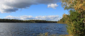
All reservoirs in the Kirov region are very beautiful. They differ in both shapes and sizes. In addition, they have a wide variety of ichthyofauna, which attracts fishing enthusiasts.
Lake Lezhninskoye
- Coordinates: 57.535767, 48.593045.
The deepest lake in the Kirov region is located in the Pizhansky district. Its maximum depth is more than 36 m. It was formed about 400 years ago at the site of a failure that arose at the top of the hill. For this reason, the banks of the reservoir are very high - up to 10 m.
The water in it is surprisingly clean and transparent, in shallow water it is colored turquoise and greenish. Among the inhabitants there are pike, roach, and crayfish. The lake is popular with fishermen, and its clear water makes it perfect for diving and spearfishing.
Beresnyatsky waterfall
- Coordinates: 57.387997, 49.029146.
20 km from Sovetsk, on the banks of the Nemda, you can see an amazing natural object, which is a miracle not only for the Kirov region, but also for the entire Volga region. This is a waterfall of extraordinary beauty, named after the village of Beresnyata, now defunct.
It consists of 3 cascades running among the rocks along a stone bed. Along its entire length, the water's path is blocked by 6 ledges, but the stream does not give up and overcomes all obstacles in its path. Local residents say that the water in it has miraculous properties, relieving headaches and intracranial pressure.
Pond Belokholunitsky
- Coordinates: 58.879300, 50.903395.
This man-made reservoir is one of the pearls of the Vyatka region. It appeared back in 1764. Then a dam was built on the river. Belaya Kholunitsa for the construction of a plant for the production of sheet and roofing iron. Water began to accumulate in the valley between Belaya Kholunitsa and Shelepikha, as a result of which a pond appeared.
Previously, finished products of the plant were floated along it, but today the reservoir is only a place of rest. In summer, its banks are actively filled with tourists and local residents. In addition, this is one of the best places for fishing. Very often, competitions among fishermen are even held here.
Lake Chvanikha
- Coordinates: 57.398329, 50.103176.
The lake in the Nolinsky district is most often called Provaly. After all, it was formed as a result of the merger of 20 karst depressions. To find a reservoir, you need to go into the very thicket of the Medvedsky Forest.
There, among the ship's pines, a beautiful lake filled with emerald water is hidden. The depth in some places reaches 15 m, so it is often chosen for diving.
Boshlyakovskoye Lake
- Coordinates: 57.922950, 49.674073.
The unusual lake is located in the north of the Kukar plateau. Tourists call it “boiling” because the surface of the reservoir is constantly seething. This is explained by the fact that groundwater comes to the surface here, which creates the boiling effect.
Unlike Lake Shaitan, they are permanent. The reservoir is not suitable for swimming - it is too shallow, but it is definitely worth a look at such beauty.
Lake Kholunovo
- Coordinates: 58.536557, 49.770512.
This is the largest floodplain lake and hydrological natural monument in the vicinity of Kirov. Located on the right bank of the river. Vyatka, just below the village of Sidorovka. The reservoir is one of the favorite vacation spots of Kirov residents. The lake is home to pike, crucian carp, perch, and roach, so fishermen do not ignore it either.
Lake Padun
- Address: pos. Sozimsky, Verkhnekamsky district.
At the beginning of the 20th century, this lake was the deepest in the region. Its depth reaches almost 29 m. It was formed at the site of a failure, which many scientists consider to be meteorite. In fact, it was underground water that dissolved the rocks over time, resulting in the formation of a depression.
The water here is very clear, which is why locals often call the reservoir “Vyatka Baikal”. The lake is located a few kilometers from the village of Sozimsky, Verkhnekamsk region.
Waterfall near the village of Pomyalovka
- Coordinates: near st. Pomyalovskoy village Kurshino, Vyatskopolyansky district.
A very interesting natural site is located in the village of Kurshino. At the end of Pomyalovskaya Street (formerly the village of Pomyalovka) there is a well that supplies drinking water to the entire street. The water from it rushes by gravity down to the bottom of the canyon and spreads out in a stream.
The waterfall looks quite powerful and has a height of 3 m. The stream is fed by spring waters that come to the surface in several places.
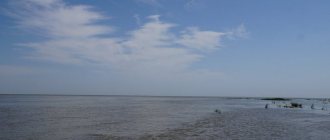
Lake Akshuben
- Coordinates: 57.642762, 47.956454.
The largest lake in the region is located in the Tuzhinsky district, in the floodplain of the river. Tansy. Its area is more than 85 hectares. With its shape it resembles a huge hippopotamus hidden in the forest.
There are no legends about it, there are no monsters hiding in its waters and there are no sunken churches. However, this is where there is a massive influx of tourists. Some come to relax from the bustle of the city, others to go fishing away from the roads.
Medvedsky Bor (Nolinsky district)
This is a relict pine forest on sand dunes with the presence of forest-steppe animal species (tarantula, antlion) and more than 30 species of steppe plants (feather grass, paniculata, sand clove). Here you can find lilies of the valley, lungwort, and corydalis. In summer - the kingdom of strawberries and mushrooms.
The karst relief of the forest is clearly expressed: there are many sinkholes, sinkholes, and lakes.
This picturesque karst lake is formed by twenty merged karst sinkholes, hence its second name - Provaly.
The length of the lake is more than a kilometer, width from 50 to 120 meters, depth up to 14 meters. The water is amazingly clear, the bottom is sandy.
Mountains, rocks and caves of the Kirov region
It is believed that the relief of the Kirov region is not diverse. However, there are also mountains and caves. Moreover, the processes of their formation did not end many centuries ago. They continue in our time, creating new amazing objects.
Remnant Sentinel
- Coordinates: 57.426111, 48.939480.
The rock with this name is located on the territory of the Chimbulat botanical-geological complex. This is an 8-meter remnant of a limestone massif. It is included in all excursion routes and is extremely popular among tourists.
Many take photos next to him against the backdrop of the picturesque surroundings. And some even try to climb right onto it. True, no one has ever succeeded in doing this. Next to the outcrop there is another interesting rock - Chimbulat, where you can see a stern male face.
Zaramenskaya Cave
- Coordinates: 57.541853, 48.938562.
The cave near the village of Zaramenye is the most famous in the Kirov region. And for a long time she was the only one. It is a grotto carved into limestone rocks by underground waters. The length of the cave is about 15 m, the rest of the cave is impassable.
Its second name is the Devil's Oven, because the entrance resembles a furnace. In the old days, gangs of robbers hid here, and at the beginning of the 20th century, clayey limestone (opoku) was mined.
Red Mountain near the village of Paska
- Address: Paska village, Kilmez district.
One of the most picturesque places is located in the Kilmez region, on the banks of the river. Lobani. The steep bank, up to 35 m high, is covered with dense mixed forest. From here you have a beautiful view of the river itself and its surroundings. Rare plant species grow on the slopes of the mountain, among which is the Lady's Slipper orchid.
Mukhinskaya Cave
- Address: city of Vyatskie Polyany.
This cave appeared naturally, but was later expanded by people. It is assumed that this could have been done by local residents when they explored it in search of cuprous sandstone.
The entrance to it is located on the rocky shore of Vyatka near the town of Vyatskie Polyany, at an altitude of 13 m. Therefore, it is not so easy to find it. The cave itself is a small grotto, which can only be reached by crawling or on all fours through a very low hole.
Boom Mountain
- Address: pos. Pervomaisky, Slobodskoy district.
A high 30-meter hill on the bank of the Vyatka in the village of Pervomaisky has long been considered a place of power. This is an ancient mound. Previously, there was a wooden church on its top, destroyed during Soviet times. Now only an Orthodox cross and a sign remain, saying that temples have always stood in this place and the ancestors of the Vyatichi people prayed.
There are many legends and rumors associated with the hill. For example, that it was here that the mythical Chud people hid in the 16th century. The name of the hill is also associated with popular belief. It’s as if the hill is empty inside and if you hit it, you can hear a rumble.
Museum-estate of A. N. Bakulev
The historical museum of Academician Bakulev, which was opened in the village of Bakuli, Kirov Region in December 1991, is very popular. The museum-estate is located in the house in which the outstanding surgeon, scientist, and public figure Academician A. N. Bakulev was born and spent his childhood.
This place contains collections of crafts and rural household items, things of the Bakulev family, surgical and medical equipment, as well as various documentary materials. On the territory of the estate there are outbuildings, a bathhouse, a mill, an agricultural pavilion and a working forge.
Springs and holy springs of the region
The Kirov region is one of the most “holy” regions of Russia. Before the revolution, it was called “The Land of a Thousand Churches.” This explains the large number of holy sources and springs that have miraculous powers.
Nizhneivkinsky mineral springs
- Coordinates: 58.199611, 49.523056.
They were known back in the 15th century. Peasants from nearby villages considered their water healing. In the 19th century, a monastery was built next to the springs and the monks began to use them for medicinal purposes. In the 20th century, a hospital was built here, which today has turned into a real resort area.
Mineral water and hydrogen sulfide mud are used for health procedures, and a good microclimate contributes to effective treatment. Each source has its own unique composition and is used for different diseases. Today, Nizhneivkinsky mineral springs are included in the list of national heritage of Russia.
Spring under Sokolya Mountain
- Coordinates: 58.161564, 48.347921.
Sokolya Mountain in the Kotelnichsky district is an amazing and mysterious place in itself. At its top there was once an ancient temple where people made sacrifices and prayed to their gods. And at the foot of the mountain there is a unique relict spring.
According to scientists, its age is tens of millions of years. The spring is fed by a gradually melting ancient glacier. The water in it is pure, without any impurities. Local residents consider it alive and claim that it energizes everyone who washes in the stream.
Holy springs Ajim
- Coordinates: 56.740278, 50.276667.
S. Adzhim, Malmyzh district - is considered a holy place. Pilgrims constantly flock to it. It's all about the springs that surround the village on all sides.
The Holy Spring is on the south side, Isaevsky spring is in the east, Kuchansky spring is in the north. The Western Spring is located between Ajim and one of the nearby villages. The water in them has no taste, no color, no smell.
Not a single spring has anything to do with faith; they are revered equally by people of different nationalities. Although, according to legend, an icon of the Bishop of Amafunt, Tikhon, was found from one of them.
Kugersky spring
- Coordinates: 57.101465, 49.858545.
The spring near the village of Kuger in the Urzhum region is called the Holy Key. And despite the fact that there are many springs in the vicinity, only this one is considered holy. After all, it was in it that Father Tikhon found the icon of the Mother of God.
He himself used the water from the spring to heal ailments and recommended it to his parishioners. Since then, the spring has become a place of pilgrimage and acquired another name - Tikhonov Spring.
Ukhtymskoe volkonskoite deposit (Bogorodsky district)
That’s what it’s called in Udmurt, but it’s better known as Shaymy. This is a puga (ridge), formed by the Lumpun and Uninka rivers, which came very close to each other, forming this watershed ridge. At the top there is a road from Unei to Porez, on both sides of which there are large sand and gravel quarries. Previously, gravel was mined here. Shaymy is located at a distance of two kilometers from the district center. A deposit of volkonskoite, an excellent natural dye, has been discovered here. Ocher and completely black sandstone, containing up to 54% manganese, are also found here.
Historical landmarks
Each region has attractions that tell its history in detail and in colors, showing the path traveled from antiquity to the present day.
Zhukovlyansky boulders
- Coordinates: 58.304727, 48.018566.
One of the mysteries of the Zhukovlyansky sand quarry is the huge round boulders. Their size reaches 3 m, and their quantity is 1500 pieces. It is still unknown where the stones among the sands came from. There are rumors among the locals that the stones are alive and can breathe. And if you touch them and make a wish, it will definitely come true.
Kovrov settlement
- Coordinates: Kovrovy village, Kotelnichesky district.
An ancient settlement at the mouth of the river. Moloma, not far from the village of Kovrovy, was discovered back in 1881. It is believed that it was one of the first settlements of the Vyatichi. During excavations of the settlement, archaeologists found a conflagration of an ancient Russian dwelling dating back to the 13th century and products from the same period.
In addition, the finds include the remains of an adobe oven, arrowheads, various tools and lead seals. Unfortunately, the archaeological monument is now under threat of destruction due to the proximity of arable land to it.
Pareiasaurus Cemetery
- Address: Kotelnich city.
One of the world's largest cemeteries of ancient pareiasaurs is located in the Kirov region. These ancient lizards are much older than dinosaurs; they went extinct about 250 million years ago under unclear circumstances.
This place is located under Sokolya Mountain, not far from the town of Kotelnich. Here, bones and skulls of fossil reptiles can be found anywhere on the beach. Currently, excavations under Sokolya Mountain are underway, but the excitement caused by the finds is gradually fading.
Istoben settlement
- Coordinates: 58.425827, 48.826946.
Istobensk in the Orichevsky district is a legendary place. Not far from it is the ancient Istoben settlement - a historical and archeological monument of federal significance. The first studies of the ancient settlement were carried out at the end of the 19th century. Thanks to this, the history of the settlement of the Vyatka land by the ancestors of the Mari and Udmurts was studied.
Local features
A variety of competitions and festivals are held on the territory of the Kirov region, among them: the All-Russian dance festival for the prize of the People's Artist of the Russian Federation V.M. Zakharov, the All-Russian competition of masters of artistic expression “My Russia” , the interregional festival of national cultures “Firebird” , the International music festival “Vyatka Spring” , open festival of social film and television programs “Vyatka” , All-Russian festival of modern man-made toys, All-Russian Vasnetsov plein air .
What to bring from the Kirov region
The Kirov region is famous in Russia for the production of footwear and fur products.
Folk crafts are widely developed here: wood painting, linen products with traditional embroidery, Kukar lace making, Dymkovo clay painted toys, products made from burl root, straw, pine root, wood, wicker, and ceramics.
National parks and reserves
Nature is something that the Kirov region can be proud of. To preserve it, many reserves and protected areas have been created in the region.
Kirov Botanical Garden
- Coordinates: Kirov, st. Karl Marx, 95.
One of the main attractions of the regional capital is the botanical garden, created by retired Colonel Istomin in 1912. Here, in a small area, there are about 180 species of trees and more than 400 small plants from all over the world.
There is a rock garden and amazing peony and lily plantations. One of the pearls of the garden is an unusual plant called the “Burning Bush” or ash tree. In hot summer weather, it becomes so saturated with oil that it can spontaneously ignite.
Natural complex Velikoretskoye
- Address: Velikoretskoye village, Yuryansky district.
The village of Velikoretskoye in the Yuryansk region is known to pilgrims and nature lovers. The places around it have been declared a natural monument. Here grow old pines, spruce and fir trees, tree-like juniper and unique multi-stemmed linden trees, as well as two types of fingerroot - plants from the orchid family.
In the village itself there is an amazing temple complex called Velikoretsky Castle. It includes a wooden church, a chapel and the source of St. Nicholas.
Bushkovsky forest reserve
- Coordinates: 57.107242, 49.517720.
The reserve in the Urzhum region was created to preserve the southern taiga and valuable tree species, to protect birds and animals, as well as to preserve natural balance. There are several rivers and springs on its territory.
But the most famous object is Lake Shaitan, the abode of evil spirits. Rumor has it that the first owner of the forest, landowner Mosolov, bathed those who illegally cut down trees in the Bushkovsky forest.
Medvedsky Bor
- Coordinates: 57.393152, 50.094310.
At first glance, the pine forest in the Nolinsky district is quite ordinary. And it would never have attracted attention if not for its unusual relief. The sandy soil on which trees grow is nothing more than relict dunes of various sizes. They have long attracted the attention of scientists.
In addition to pine trees, mainly steppe plants grow in the forest: feather grass, snapdragon, sand carnation. You can find a tarantula spider and an antlion. The pride of the Medvedsky Forest is Lake Chvanikha, formed as a result of the filling of karst sinkholes with water.
Atar bow
- Coordinates: 57.521667, 49.290000.
Despite the fact that this national park is still under construction, it is already attracting the attention of tourists, fishermen, mushroom and berry lovers. The territory where the new facility is planned to be located will be at the junction of three districts - Nolinsky, Lebyazhsky and Sovetsky.
This is the southern taiga and floodplain of Vyatka, coniferous forests and birch forests, habitats of the otter and reindeer, golden eagle and eagle owl. In addition, the park area may include such natural monuments as the Medvedsky Forest and the Kotelnichsky burial site of pareiasaurs.
Natural complex Oshet
- Coordinates: 58.005450, 50.054304.
This is a completely new natural monument, created with the aim of preserving and protecting spruce-fir forests. It is located in the Verkhoshizhemsky district, and the area of the protected territory occupies more than 9,000 hectares.
In total, 394 species of plants grow here, 8 of which are listed in the Red Book of Russia and the Kirov Region. Among animals and birds, 9 species are also considered rare and endangered.
Heather forests
- Address: Afanasyevskoe forestry, Borskoe district forestry.
Common heather is listed in the Red Book of the region. In the northeast of the Kirov region, where the southern distribution area of this plant passes, a natural complex has been formed.
The heather forest occupies 1,600 hectares in the Kaysky, Borsky, Afanasyevsky and Ozhmegovsky forest districts. An environmental protection regime has been established throughout the entire territory of the natural monument.
Philaean population of Cortus Mattioli
- Coordinates: 58.649087, 49.609907.
Cortusa Mattioli is a relict plant preserved from the Ice Age. In the Fileyka microdistrict of Kirov, a population of this rare plant was discovered, numbering 900 specimens. The growing area of Cortuse Mattioli covers an area of about 5 hectares and is declared a botanical natural monument.
You may be interested in interesting places in individual cities of the Kirov region - Kirov
Velikoretskoe
The village is famous for the Velikoretsky Castle, a vast temple complex from which the religious procession begins on Orthodox holidays. The cathedral complex includes several churches, the Nikolo-Velikoretsky Monastery , a chapel, a bell tower and shopping arcades. All buildings date back to the 18th-19th centuries.
Velikoretskoye is also known for its picturesque natural monuments.
Velikoretskoe
Where to go in the Kirov region with a child
It will be very important for vacationers who go on vacation with children to know where they can relax with the whole family. There are places in the Kirov region that a visit to will impress both young travelers and seasoned tourists.
Dinopark Dinosaurs on Vyatka
- Address: Kotelnich, st. Volodarsky, 10.
The best place for a family holiday in the Kirov region is the Dinopark in Kotelnich. The once-abandoned ravine in the city center has been transformed into a branch of Jurassic Park. Here visitors are greeted by tyrannosaurs and iguanodons, apatosaurs and deinonychus, made life-size from rubber and plastic.
There are also babies that have just hatched from eggs, and the pride of the Kotelnichsky region - pareiasaurs. To make it more convenient to view the huge reptiles, observation platforms have been built, and walking paths have been laid between the sculptures. A visit to the dino park will not leave either children or adults indifferent.
Yurkin Park
- Address: Kirov, Talitsa village, st. Talitsa, 50.
Another park with dinosaurs is located in Kirov. It differs from Kotelnichsky in that the fossil giants move and make sounds here. There is a sign next to each dinosaur where you can read information about it.
Such as height, weight, nutritional habits. Little naturalists can also take part in real archaeological excavations. In addition, on the territory of the entertainment complex there are food courts, a swimming pool, and a beach opens in the summer.
Sports and tourist complex Poroshino
- Address: Poroshino village, Borovitskaya st., 36.
A wonderful place for a family holiday is located in a picturesque place in the middle of a forest, not far from the regional capital. Active recreation lovers of all ages are welcome here.
Visitors are offered horseback riding, quests and game programs, and health trails at different distances. The rope park has trails of varying degrees of difficulty for children and adults. To be more mobile, you can rent a balance bike, electric scooter or Segway.
On the territory of the complex there is a bathhouse, tents and holiday houses, and a cafe with a wide variety of menus. There is no place for melancholy and despondency. No one has ever left Poroshino dissatisfied.
Singing Sands
- Address: Lebyazhsky district, Atary village.
The sandbank near the abandoned village of Atary is a specially protected natural site. This is because here you can see one of the most unusual phenomena not only for the Kirov region, but also for Russia - amazing singing sands. You can hear them in only a few places in our country, and one of them is located on the banks of the river. Atar.
Sand begins to sing only in windy and dry weather. If you just walk on it, it makes a creaking sound. This happens due to the movement of grains of sand consisting of rock crystal and milky quartz. Under the influence of wind, they compress and then expand and become electrified. The stronger the wind and the larger the grains of sand, the more interesting the melody and the louder the sound.
Rare plants growing in the Sovetsky region, including on the rocks
Named after the now defunct village of Beresnyata. The total height of the waterfall is 25m. It consists of 6 ledges, with a height of 1 m, 2.5 m, 1.5 m, 2.5 m, 4 m, 7.5 m.
Paint and varnish materials "Vyatkakraska"
For 17 years, experts from the innovative enterprise “Vyatkakraska” have been producing high-quality paints and varnishes. The plant is unique for the Kirov region; there are no similar enterprises in our region.
Over many years of work, the Kirov company has earned a reputation as a reliable partner, and Vyatka paint has been awarded numerous diplomas and is in demand in various regions of Russia. Geography is not limited to the Urals and the Volga region. Now paint produced in Kirov is used in the Kaliningrad region, Khabarovsk region, Yakutia and so on.
Materials produced by Vyatkakraska are used at the largest facilities, including buildings of the Ministry of Defense, large shopping centers, and sports facilities: the railway station in Kirov, the Jam Moll shopping center, the Perinatal Center, the industrial park in Vyatskie Polyany, the Kirov Meat Processing Plant, Food Zavod , rocket, Strigino international airport (Nizhny Novgorod), Kazan helicopter in Izhevsk, Perm printing factory Goznak, Magnit hypermarkets.
Fire retardant products occupy a special place among the materials produced at Vyatkakraska. Modern high-tech coatings undergo all necessary tests, are tested daily by our own laboratory and annually confirm their quality in testing centers. All materials are repeatedly tested in practice, because the plant understands that the cost of an error or defect in production is human life.
Sculpture Family
Not long ago, a sculptural composition called Family was installed near the building of the Puppet Theater. The ensemble is made in the traditions of Dymkovo toys, it is a man with an accordion sitting on a bench, a woman with a child in her arms, a little boy standing next to him, a cat and a dog complete the composition. Next to them there is a place where you can take a photo or just sit on a bench.
The monument has become a symbol of family unity, and newlyweds come here to make a wish that will surely come true.
Address: Kirov, st. Drelevskogo, 22
“Miracle bread” from Kirovo-Chepetsk
Kirovo-Chepetsky Bread Factory is one of the oldest enterprises in the Kirov region. For more than 60 years, the bakery has been pleasing residents of the region with delicious and high-quality products.
Today, under the brand name “Miracle Bread”, in addition to the well-known varieties of bread, rye and rye-wheat custard breads with healthy additives are produced - raisins, malt, caraway seeds, bran, and so on. Bread is prepared using lactobacteria sourdough - such products are healthier, and the bread is less susceptible to spoilage.
The highlight and real pride of the bakery are the croissants, poppy seed rolls and rolls with fillings that are loved by customers. All puff pastry products of the bakery are distinguished by their splendor and exquisite taste.
The bakery never ceases to delight those with a sweet tooth with a large assortment of pastries and pies. The legendary "Kiev" cake, "Flight" with peanuts or cashews, "Bird's milk", "Count's ruins", eclairs, rum women... You'll lick your fingers!
The bakery also produces truly unique sweets. For example, jelly marmalade with cranberries. This is a healthy treat for adults and children because it contains real cranberries and is not sprinkled with sugar.
The products of the Kirovo-Chepetsky Bread Factory have received wide recognition not only from consumers, but have also been awarded the highest ratings from leading experts in this field, as evidenced by the prizes and awards awarded to the products at various Russian exhibitions.
theatre square
Theater Square is a popular place in Kirov. There are always a lot of walking students, families with children, and couples in love. The square is considered the real center of the entire cultural life of the city. This is where all the city holidays take place, and local residents nickname the square “theater room”. The building of the Regional Legislative Assembly is located on the square.
The Kirov Drama Theater gave the square its name.
Vyatskaya Vasnetsov is a museum visited by tourists coming to the city.
Address: intersection of Karl Liebknecht, Moskovskaya and Karl Marx streets
Church of John the Baptist
A monument in Kirov that has great historical value is the Church of John the Baptist. It began to be built in 1714 on the outskirts of the city. The work was completed after 9 years, and at the end of the century the building was rebuilt, in particular the height of the main nave was increased.
During Soviet times, the church housed the Society for the Protection of Monuments, and the building was converted into a planetarium. The temple was returned to the Vyatka diocese in 1994. And at the moment it is the most beautiful landmark of the entire Vyatka region.
Address: Kirov, st. Svobody, 54d Phone: +7 833 265‑03-61 Open: daily, 7:00–19:00
Cheese “Slice of the Sun” (Kotelnich)
, in the city of Kotelnich, celebrated its 85th anniversary in 2015. It’s so nice to come to a store and see products there that you’ve known since childhood... It’s doubly nice that their taste remains the same, unchanged. This also applies to sausage cheese, the taste of which is familiar to everyone since those very Soviet times. It is produced under the brand name “Slice of the Sun”. Cheese is produced on the basis of natural peasant butter, without the use of milk fat substitutes. As they say on, the cheese is smoked on natural sawdust, due to which everyone’s favorite “smoky” taste is achieved.
Today it offers more than 60 types of different cheeses. These are everyone’s favorite hard cheeses “Poshekhonsky”, “Gollandsky”, “Russian”, “Kostromskoy”, in individual vacuum packaging, and soft cheeses “Legend of Altai”. The plant also produces the most famous processed cheeses: “Druzhba” and “Omichka”. were the first in the country to launch the production of all-natural processed cheese in a tube! Today, the traditional “Druzhba”, “Yantar”, “Chocolate” and several other names are easy to take with you on the road and to the dacha.
Italian “Mozzarella”, Georgian “Suluguni” and Bulgarian “Kachkaval”, and even curd cheese “Vitalini” are the pride of the Kotelnichesky plant. All these products are ideal for preparing dishes of any cuisine in the world. And, of course, the traditional products of the plant - butter, milk - are very loved by our customers.
Residents of the Komi Republic, Udmurtia, Tatarstan, Perm Territory, Vologda, Ivanovo and Vladimir regions have long fallen in love with the products of the Kotelnich plant. Today, natural products under the Yantar brand are recognizable throughout Russia and can rightfully be considered a national Vyatka brand.
History of the Vyatka region
According to historical records left by Karamzin, Novgorodians came to this region in the 12th century. and founded the first settlements here. The first name was given to the city in 1780 by the Russian Empress Catherine the Second, who ordered it to be called Vyatka. Its origin, according to local historiography, is from the name of the Udmurt tribe “Vatka”. According to another popular version, the name comes from the Old Russian word “vyache” after adding the suffix “ka”, which means “big”.
Another name of this place - Khlynov - according to historians, comes from the probable name of the person who founded the settlement in the 15th century. Translated, this word means tramp or swindler. According to popular legend, the entire Novgorod people, who were distinguished by their obstinate, independent and proud disposition, were nicknamed Khlyn. Thanks to their character and military successes, the Vyatka lands were independent from the Tatars and Moscow princes for several centuries.
In the Middle Ages, these lands were inhabited by peasants who were engaged in farming, hunting, fishing and beekeeping. Due to the rapid development of local crafts and the establishment of trade with neighboring cities, Vyatka quickly became the center of a large region, and not the outskirts of the Russian state.
Alexander Garden
One of the oldest parks in the city, Alexander Garden, was founded in 1825, after Alexander the First visited Kirov.
A good location was chosen for green spaces between the Razderikhinsky ravine and Vyatka; the territory occupied the space between the Pyatnitsky Church and the Transfiguration Monastery.
By 1835, the garden was improved, with nice alleys, gazebos, and a stone bridge. The natural landscape fits well into the overall picture. Today, the Alexander Garden is the best example of park design dating back to the era of classicism.
Address: Kirov, Alexandrovsky Garden
Wish tree
In the park, not far from the Drama Theater. Kirov has a unique composition, the Tree of Wishes. Laying the foundation for the tree lasted a week. Letters with the wishes of the townspeople were placed in a box under the tree, that is, thanks to this, it grows, of course, only symbolically.
The opening of the art object was a celebration. At the ceremony, those present shouted “I allow” in unison, which became a sign that the tree would grow and fulfill everyone’s wishes to the joy of everyone. An ear is carved on a tree; everyone can come here and whisper their deepest desire. It is interesting that the concrete tree looks like a real one, it is so skillfully made by craftsmen.