Shavlinskie lakes
Shavlinsky lakes are one of the most beautiful natural attractions of Altai. a string of several Altai reservoirs stretches for 10 km in the Shavla River basin near the North Chuysky ridge. The state-protected territory is famous throughout the world for its amazing beauty. The lakes, surrounded by snow-white glaciers and mountains overgrown with forests, attract artists, photographers and tourists with the amazing purity of the water in amazing colors, which reflects the snow-covered mountain peaks - Fairy Tale, Beauty and Dream. Famous Russian travelers, comparing the nature of this region with the alpine landscape, give preference to Altai.
Each body of water has its own name. The Upper Lake, with its sloping shores consisting of huge boulders, is located at an altitude of more than 2 thousand m. The western shores of the most beautiful Lower Lake, located 5 km from the Upper Lake, are steep and rocky. On the eastern side the reservoir is surrounded by deciduous forest. This place is convenient for tourists.
Yarovoe
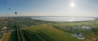
A small resort town located in the Kulunda steppe zone, 450 km from Barnaul. The main attraction is the large salt lake. The beneficial properties of water and silt mud are used to treat skin diseases, diseases of the musculoskeletal system, nervous system, etc.
There is also a lot of entertainment here: a large water park, an open-air theater where various holidays and parties for young people are held.
Vacationers are also offered to fly by plane and hot air balloon, go on excursions to the Kulundinskoye and Maloe Yarovoye lakes and the natural reservoir “Teply Klyuch”.
National Museum named after A.V. Anokhina
The oldest cultural landmark of the Altai Republic, which recently celebrated its centenary, bears the name of its founder - an ethnographer, researcher of the traditions and culture of the South Siberian peoples. The collection began when the Altai Zemstvo Administration acquired a collection of exhibits, scientific books and archives from the famous Siberian scientists the Gulyaev brothers. After several moves, the museum finally settled in Gorno-Altaisk.
The exhibition covers historical periods from archaic times to the present day. It includes household items, photographs, historical documents, ancient books and manuscripts, artistic and decorative works, collections of minerals, flora and fauna.
The modern multi-tiered complex, which contains the famous sarcophagus of the “Altai princess”, is designed in the style of a mound.
3. Belukha
Belukha, crowning the Katunsky ridge, is the highest peak of the Altai mountain range. Situated on the border between Russia and Kazakhstan, the three-headed mountain was named for the color of its snow-capped peaks and one and a half hundred glacier-covered slopes. The Katun River originates there. Two peaks more than 4.5 km high - Western and Eastern - are irregular pyramids. Between them, at an altitude of 4 thousand m, is the Belukha Saddle, and on the edges are the peaks of Delaunay and Crown of Altai. Lovers of exotic nature admire one of the highest waterfalls in the region on the way to Lake Akkem with clear water and the reflection of a mountain peak in it. Since 2000, the territory received the status of a National Park.
The slopes of Belukha are popular among climbers and tourists seeking to get acquainted with the nature, history and culture of this place. Mystics consider the mountain sacred. Buddhist beliefs claim that the legendary Shambhala is located here, from where the great Buddha went to India. Local residents believed that the ice caves were inhabited by ferocious spirits that were dangerous to people. Fans of esotericism often triple their meditation on the shamanic stone.
Historical tourist places of the Altai Territory
The history of Altai goes back many millennia, so many cultural monuments remain. They are witnesses of a particular era.
Pazyryk mounds
There are excavations in the Ulagansky district near the village of Balyktuyul. The complex includes a large number of burial objects and an irrigation system. The era in which representatives of this culture lived here is the fifth century BC. You can learn about the amazing discoveries made while working on the ground in the nearby museum.
Altai Stonehenge
Stone pillars, standing firmly in the ground and having petroglyphs carved on them as decorations, are located between two mountain peaks - Sailyugem and the South Chuysky ridge. The six-meter stones, according to scientists, are the burial place of shamans. And according to popular beliefs, being here can provide emotional and spiritual cleansing.
Rock Bichiktu-Kaya
At this place there was previously a defensive structure, an outpost; at the moment, only a bomb remains in the form of a steep stone plumb with engraved hieroglyphs. Translated, the name means “written stones.” There is still debate about who owns the fortification, but the first drawings date back to the Bronze Age. The historical monument is located a few kilometers from the village of Inya.
Altai Nature Reserve
The Altai State Nature Reserve, created in 1932 to protect the flora and fauna of the taiga and high-mountain tundra, is located at an altitude of 2.5-3 thousand m near the center of Asia, in the southeast of the Altai Mountains. It is especially protected and included in the UNESCO World Heritage List.
The most important task of this Altai attraction is the preservation of the original Lake Teletskoye with amazing waterfalls, the surrounding coniferous forests and their inhabitants, who are in danger of extinction. The territory of 230 km is covered with dense forests, alpine meadows, fast-moving rivers, streams and springs with icy clear water. The biological diversity of the reserve is amazing; many representatives of flora and fauna are included in the Red Book of the Russian Federation: reindeer, snow leopard, musk deer.
What to visit in Altai: museums
Museum lovers can get acquainted with the history and culture of the region by visiting the following attractions. The entrance fee is minimal almost everywhere.
National Museum named after A.V. Anokhin
This is the largest museum complex, built 100 years ago. Its founder has assembled a luxurious collection, which has now been expanded to include more than 60,000 unique pieces. Address: Gorno-Altaisk, st. Grigory Choros-Gurkina, 46.
Ten-handle
In the village of Cheposh there is an exhibition hall, which presents elements of the culture and applied art of the peoples who lived in this territory - pottery, wet felting, etc. You can immerse yourself in the atmosphere and become involved if you take part in a training master class.
House-Museum of N.K. Roerich
Every good, diligent tourist will not pass by an exhibition of paintings by the famous artist, after whom the museum complex was named. Few people know that he also conducted expeditions, in one of which (in the Altai Mountains) he painted many outstanding paintings. Now they can be viewed in the exhibition hall.
Lake Teletskoye
The reservoir, popular among Russian and foreign tourists, is located in the northeastern part of the Altai Mountains on the border of the Western Sayan Mountains. It is included in the UNESCO World Cultural and Natural Heritage List. The lake is considered one of the iconic places in Altai. The object received its name 400 years ago from Russian travelers who met local residents from the Turkic Teles tribes on the coast of the reservoir. The indigenous inhabitants called it Altyn-Kul (Golden Lake), the inhabitants of Mongolia say: Altyn-Nuur, the Chinese are familiar with it under the name Artai.
The name is associated with the legend of a thrifty Altai man who hid a gold nugget the size of a horse's head for a rainy day. In a hungry year, he tried to exchange this value for food for his family, and when that didn’t work, he threw a piece of gold from a high mountain into the lake and jumped there himself.
For many residents of Asia, Lake Teletskoye is a shrine. The main attraction of the reservoir is the Korbu waterfall, popular among travelers, with an equipped observation deck and the largest cascading waterfall, Uchar, 160 m high. Nowadays, adventure and eco-tourism is gaining popularity in the region.
Mountains Big and Small Monastery
Snow-white cliffs with caves, grottoes and arches are located in the valley of the Charysh River.
The hundred-meter-high Big Monastery Mountain is replete with caves. The topmost one is Bastion, a site for Stone Age people. Ancient arrowheads were found in it.
The Small Monastery is slightly below it. It is crowned with a stone gate, there are a dozen caves and a stone arch. The largest of the caves, Vodyana, is located near the waters of Charysh. It has a tiny lake with healing water.
The legend tells of the love of the daughter of the king of the mountains and the son of the king of the waters, who were separated by their parents. The young man was turned into a river, and the girl, hidden in a cave, drowned in a lake of tears. The lake washed a passage underground, connecting with the river. This place is popular with lovers.
Kamyshlinsky waterfall
A natural object - a 12-meter cascading Kamyshlinsky waterfall is located on the left bank of the Katun River, near the mouth of its tributary Kamyshly. The picturesque landscape attracts a lot of tourists who enjoy admiring the splashes crashing on the rocks and shimmering in the rays of the sun. One of the two makes a spectacular impression - the main rocky cascade. In winter, the waterfall freezes and the drops become ice crystals.
The legend explains the origin of the waterfall as a romantic love story between the beautiful daughter of the leader of the La tribe and the hero Kamysh, who protected her from prying eyes. The father who found them together ordered the faithful warrior to be thrown off the cliff, and the girl herself jumped after him. The leader, who died of grief, was buried on the top of the mountain, and the waterfall that soon appeared was named Kamysh-La in honor of the lovers. There are other versions of the origin of the reservoir.
Cascade of waterfalls on the Shinok River
The name of the Shinok River (a tributary of Anuya), falling from an almost two-kilometer height and flowing through a rocky cedar gorge, means “impregnable.” There are more than a dozen waterfalls along its length. Their height ranges from three to 72 meters. The largest waterfall, Giraffe or Sedoy, is also the leader among Altai waterfalls. An equally stormy Double Jump, three times as tall as the leader.
Each of the waterfalls ends with a corresponding bath and continues with a rocky gorge of the river stream that follows it. The mouth of the river is flat and calm. Its composition differs little from mineral water. And the three largest waterfalls are recognized as natural monuments.
7. Chike-Taman
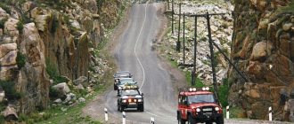
The height of the mountain pass, a republican natural monument, is 1295 m. Chike-Taman stretches for 11 km, starting at 655 km of the famous Chuysky tract. Until the turn of the 19th and 20th centuries, the pass was crossed along an unsafe horse-drawn road with many risky turns. In 1903, a narrow crushed stone highway with 24 turns, which served for 80 years, was planned by the engineer and writer V. Shishkov, who wrote the famous novel “The Gloomy River”.
During archaeological excavations, the remains of an ancient road dating back a thousand years were discovered, which is now visible from the observation deck at the top. The name of the pass translated from South Altai means “straight sole”.
The road carved into granite meanders along the northeastern foothills of the Terektinsky ridge between sheer cliffs and deep gorges. Tourists observe magnificent mountain landscapes: deciduous and cedar forests, overgrown with bushes and herbs. Caves and gaps in the area of the bridge attract fans of extreme tourism and speleologists.
Oroktoy Bridge
One of the most stunning architectural sights of Altai is a suspended automobile structure over the Katun River in its narrowest and deepest (70 m) place. The river bottom of the depression is covered with rapids. The length of the 3-meter wide bridge is 95 m. It was erected to replace a wooden structure that was demolished by a flood in 1990. For several years, residents of the village of Oroktoy had to cross to the other side in a suspended cradle.
The bridge offers an amazing view of the deep canyon and the rapid flow of the river seething on the rapids, which attracts tourists.
The indigenous people created a legend about the history of the cableway about the hero Sartykpai, who collected and carried huge boulders to build the bridge. But the structure collapsed after completion. Only the Oroktoy Bridge survived.
Devil's Finger Mountain
One of the most impressive natural attractions of the Altai region is Mount Devil’s Claw near the Katun River and Lake Aya. Its name is associated with the shape of a mountain protrusion, similar to part of a human hand. The similarity is aggravated by the claw-shaped visor on the top of the rock, which rises 250 m above the surface.
Thanks to the easy climb, travelers enjoy admiring the panorama of the surrounding area, meeting romantic sunrises and sunsets, and enjoying the silence and morning birdsong.
Followers of esotericism consider this place suitable for meditation. Scientific research has proven that under the rock there is an impressive geomagnetic field that intensely radiates positive energy. Altaians attribute healing powers to the mountain in the treatment of infertility.
A folk legend tells of a duel between a brave Altai warrior and the monster Cherto, who had seized his land, and defeated an entire army. The hero trampled the enemy into the ground with his horse, and all that remained was his finger protruding from the ground.
Rock Four Brothers
At the time of the emergence of the Belokurikha resort (almost two centuries ago), a natural composition of rock towers in the form of four ten-meter likenesses of people, which was nicknamed “Four Brothers,” became known. There is a path leading to it, where squirrels and chipmunks can jump without fear of humans.
This harmony of man and nature is completed by rare birds living near the path. The “brothers” are surrounded by legends. One of them says that these are really brothers who sacrificed themselves to save their only sister from a forest monster.
Valley of the Seven Lakes
A small valley 10 km from the famous Belukha Mountain is one of the most beautiful corners of Altai, famous for its marvelous alpine meadows and numerous alpine lakes and waterfalls, located at an altitude of more than 2 km. The valley is surrounded on all sides by the peaks of the Katunsky ridge covered with eternal snow. A picturesque path leads there, surrounded by cedar and bushes. From a bird's eye view, the shape of the hollow resembles a heart.
The Valley of the Seven Lakes consists of three tiers. The upper one is located at an altitude of 2600 m. On the third, most beautiful tier there are 4 lakes fed from a mountain stream. They are painted in inimitable shades. The water of one of them appears black due to the stones covering the bottom. In summer it warms well and is suitable for swimming. In the deepest lake, the water is turquoise, through which the yellow sandy bottom shines through. The coast and islands of the last lake are covered with snow-white flowers, for which it is called the lake of brides.
Splices
A small village in the Biysk region (195 km from Barnaul). Srostki is the birthplace of the writer, actor, and director Vasily Shukshin. Here he filmed the film “There Lives a Guy Like This.”
In Srostki you can visit the V.M. Shukshin Museum-Reserve, visit the house where he spent his childhood, and sit at Vasily Makarovich’s school desk. But the most important thing to do in Srostki is to climb Mount Piket. There is a monument to the writer there, and also a beautiful spacious view of the Altai nature opens from there.
Sartakpai Gate
The tight rocky 100-meter gorge at the confluence of the Chemal and the Katun is called the Sartakpai Gate. The width of the spectacular crevice is about 50 m. Getting down to the water is very difficult even for professionals, so people usually admire the sight from the “goat path”, which is used by tourists and indigenous residents.
Local legend says that in ancient times, the hero of the folk epic, the hero Sartakpai, manually laid the beds of Altai rivers locked in the southern lake in the northern direction. The Katun was supposed to be led by the giant’s young son, but he did not have the strength to crush the rocks along the river’s path. The riverbed twisted heavily, and living on the banks was extremely inconvenient. The father decided to correct his son's mistakes. He took his metal bow and fired a copper arrow that split the rock in half. The water has a direct path.
Gorno-Altai Botanical Garden
The Altai branch of the Siberian Botanical Garden is located in the “Chisty Meadow” tract, on 60 hectares of a natural monument limited by the natural boundaries of the Katun, Sema and Sosnovaya rivers. It is a huge clearing surrounded by mountains and relict forests. The uniqueness of the landscape is ensured by artistically carved river banks, islets and bays.
In the garden with a special climate, there are unique ancient and endangered plant species, the collection of which is regularly updated thanks to the scientific research of the staff. The natural landscapes of the garden are successfully combined with the design of ponds, rock gardens, and paths. A special ethnographic exhibition tells about the culture and life of the region.
Belokurikha mine
The new route “Belokurikha Mine” is designed for lovers of active recreation in the mountains. The tour begins with a memorable climb along the serpentine road leading to Belokurikha-2. The starting point is the Belokurikha-2 sanatorium-resort development zone.
In 2015, according to the design of sculptor Vladimir Voychishin, a six-meter chair with the thinker imprinted on it was installed here. On the way, you can stop at a hunting hut, where guests are introduced to the life of a hunter and treated to honey. After this, tourists get to the Belokurikha mine. From 1939 to 1954, tungsten was mined here on an industrial scale.
For more than half a century, the mine itself and the road to it were completely abandoned, but today guests can look into the ore mine, get acquainted with the tungsten mining technology, see some preserved and restored parts of the mining and processing plant, and even listen to the memories of the mine’s contemporaries.
Lake Manzherokskoe
Thanks to its pristine beauty, Lake Manzherok, popular among tourists, was recognized as a natural monument. It is located near the Chuya tract in the Katun basin at the foot of Mount Sinyukha. The lake was once formed from a loop of a river bed that turned into an oxbow lake. Thanks to the 3-meter depth, the water here is well heated and suitable for swimming, but vacationers are disturbed by the marshy shores in places.
The lake is surrounded by hills covered with coniferous forest, birch and bushes. There are a lot of wild birds listed in the Red Book here. The reservoir recently attracted fishing enthusiasts with an abundance of pike, tench, and carp. Lake water is saturated with useful substances. The peculiarity of the lake is a large amount of aquatic vegetation. One of them is rogulnik, listed in the Red Book.
The name Manzherok became famous after E. Piekha performed a song dedicated to the festival of Russian-Mongolian friendship.
Natural attractions
Chuysky tract
The Chuysky tract is one of the most famous and ancient roads not only in Altai, but throughout Russia. This is one of the 10 most beautiful roads in the world according to National Geographic. The first mentions of this road were found in Chinese chronicles dating back to the last millennium. At that time, the Mungal tract was still used by traders and warriors traveling from Russia to Mongolia and China. The modern Chuisky tract is a paved road that leads from Novosibirsk through Altai to Mongolia, and then through China to the Arabian Sea in the Pakistani port of Karachi.
In addition, the Chuysky tract is the main road that tourists use to travel around Altai. Not far from it are the tourist centers of Chemal and Turyuzovaya Katun, the famous Katu-Yaryk pass and the valley of the Chulyshman River. The tract passes both through the Southern and near the North Chuysky ridge. Well, driving along the historical part of the tract from Biysk to the border with Mongolia, you can see Mongolian burial mounds and stone women (images) guarding them.
"Altai Mars"
Do you want to go on vacation in Altai and suddenly find yourself on another planet? Let's say on Mars? Then you definitely need to go to the valley of the Kyzyl-Chin River, which is located 7.5 km from the Chuysky tract in the Altai Republic. Due to the fact that the local soil is full of polymetallic ores, the color of the mountains here acquires multi-colored shades. Mostly red. In addition, there is almost no vegetation on such soil. All this makes the valley of the Kyzyl-Chin River a real Mars.
The Martian Valley in Altai, although a famous place, is not as popular as the Katu-Yaryk pass. Therefore, there will not be huge crowds of tourists here, which means you can walk around the local Mars in relative solitude and feel like a real explorer of another planet. And, of course, the photographs from these places are simply exceptional. So if you've ever dreamed of becoming an astronaut, it's time to make that dream come true in Altai.
Geyser Lake
Small (only 30 meters in diameter), but colorful Geyser Lake is located in the Altai Republic, 165 km from the border of Russia and Mongolia. The lake in Altai surprisingly resembles the American lake in Yellowstone Park. In its middle, geysers also come out, and with them blue silt rises to the surface from the bottom. Thanks to this, the water in the Altai lake acquires an unusual blue hue. From the center of the lake, this silt spreads out into concentric rings and gradually changes its color.
Katun River
Katun is the main river in Altai, even its name is translated from Altai as “mistress”. The source of the river is located on the slope of the highest mountain in the region - Belukha. Then Katun spills throughout the region, passing through the territory of the Altai Territory and the Altai Republic. The most popular place to relax on the river is the special tourist zone “Turquoise Katun”. There are hotels, cafes and shops here, and excursions and expeditions around Altai depart from here.
In addition to the tourist and entertainment infrastructure, in the vicinity of Turquoise Katun there are several interesting places where it is worth going on an excursion:
- Tavdinsky caves with a length of 5 km, located on the left bank of the river;
- Tavdinskaya arch is a karst arch (width - 13 meters, height - 5 meters) in the mountains above Katun;
- Maralniks are special farms in Altai where rare maral deer are bred. These deer are known for their antlers, or rather antlers, which are widely used in medicine and cosmetology.
Mount Belukha
Mount Belukha is the main one among all the natural attractions of the Altai Mountains. This is the highest peak in Altai - 4509 meters above sea level. It is located on the Katunsky ridge. The border between Russia and Kazakhstan runs along this mountain range. The mountain itself belongs to the Altai Republic and is part of the Katunsky Nature Reserve. In addition, it is included in the UNESCO World Heritage List as part of the Golden Mountains of Altai complex.
Belukha got its name because of the abundance of snow, which covers it almost to the very foot. Locals call the mountain differently. In Kazakh, her name sounds like “Kadyn-Bazhy”, which means “Top of the Katun”. In the South Altai language (one of the main languages in the Altai Mountains), Belukha is known as “Uch-Sumer”, or “three-headed”. You can’t argue with either one. One of the most famous rivers in Altai, the Katun, originates from the slopes of Belukha. Well, the mountain itself actually has several peaks.
Katu-Yaryk pass and Chulyshman river valley
The valley of the Chulyshman River is one of the pearls of the Altai Mountains. There are three main reasons why tourists are so attracted to this area:
- from the top of an almost 900-meter mountain there is a breathtaking view of the valley of the Chulyshman River;
- the descent into the valley, where all tourists rush, takes place along an amazing, although quite dangerous, mountain serpentine (3.9 km long) at the Katu-Yaryk pass;
- The tourist infrastructure is quite developed here, there are cafes, equipped toilets and a parking lot.
However, remember that the Katu-Yaryk pass is not only quite dangerous for inexperienced drivers, but also treacherous even with professionals. Almost any car can go down to the valley of the Chulyshman River along a steep mountain serpentine road, but many people cannot go back up. It is best to use SUVs that are not too overloaded on the pass.
"Stone Mushrooms"
Ak-Kurum stone mushrooms are high rocks that stand alone on the slopes of mountain ranges in the valley of the Karasuk River. Ak-Kurum means “white scree”. In Altai, scree (kurum) is precisely the name given to huge boulders resulting from the weathering of rock. So stone mushrooms in Altai appeared in the process of soil erosion - wind and precipitation gradually carried away pieces of rocks.
Why do we call these rocks stone mushrooms in Russian? The fact is that on the tops of these weathered rocks there are massive boulders that from a distance resemble mushroom caps. True, if you want to see this miracle of nature, then you should hurry. The Ak-Kurum stone mushrooms continue to collapse. In addition, periodic earthquakes in Altai negatively affect this natural attraction.
Lake Teletskoye
Lake Teletskoye is the largest in Altai. Its area is 223 km², and its depth reaches 325 meters. The lake contains a large supply of clean fresh water, and its transparency reaches 14 meters in depth. That is why Lake Teletskoye is often called small Baikal. However, like Baikal, it is recognized as a UNESCO World Heritage Site as part of the Golden Mountains of Altai complex.
The Teletskoye Lake area is extremely popular among tourists. There is all the necessary infrastructure for recreation, and in the surrounding area you can walk along mountain trails and see several other natural attractions:
- Korbu waterfall is one of the most famous in the Altai Mountains. Its height is 12 meters, and at the mouth of Korbu is the deepest place of the lake. The only way to get to the observation deck at the waterfall is to come here by boat.
- Stone Bay is located 4 km from the village of Artybash - the main tourist center on Lake Teletskoye. According to legend, a meteorite fell into this place, and that is why the coast of the bay is strewn with huge boulders, some of them taller than a man.
- Kishte waterfall translated from Altai means “calling”. It is significantly smaller in size than Korb. However, here a much larger volume of water falls at an incredible speed. That is why Kishte is considered the loudest waterfall in Altai.
- Yailyu pine grows almost at the very edge of the water on Lake Teletskoye. The tree is called “bowed”, or drunk. Even in the last century, a pine tree in the village of Yaylyu tilted strongly towards the ground. Tides and storms on the lake have washed away all the soil from its roots, but the tree continues to cling to the ground and grow even in this state.
Ukok Plateau
The Ukok plateau (or plateau) is located in the Kosh-Agach region of Altai and is considered one of the most mysterious places on the map of Russia. The location of the plateau is such that it is equidistant from the four oceans; In addition, Ukok is located on the border of four countries: Russia, Kazakhstan, China and Mongolia. Its average height ranges from two to two and a half thousand meters above sea level.
From the Mongolian language “Ukok” is translated as “cabinet”, “elongated box” or “massive mountain”. The plateau is known not only for its amazing landscapes and harsh climate, but also for its archaeological finds. For example, it was here that the ancient burial of a girl was discovered - the famous “Altai Princess”.
Multinskie lakes
Multinskie lakes are a whole cascade of lakes in the upper reaches of the Multa River. There are three lakes in total: Lower, Middle, Upper. Nearby there are also lakes Poperechnoye, Verkhneye transverse, Kuiguk and Krepkoye. The Multinskie lakes are located quite far from populated areas, and a trip to them will turn out to be a real hiking trip. People usually get here on foot or in off-road vehicles.
In summer, the water heats up to fifteen degrees, and it is quite possible to swim in the lakes. But first of all, people come to this area for the scenery and walks in the surrounding area. Coniferous forests, boulders covered with cedars, mountain slopes, clearings and picturesque trails equipped for tourists, mirror-like surface of water and the sound of waterfalls - all this awaits travelers who go to Multinskie Lakes.
Shavlinskie lakes
The chain of Shavlinsky lakes stretches along the North Chuysky ridge for almost ten kilometers. These lakes are famous throughout the world - not only for their beauty, but also for the amazingly rich color of the water: blue, green, azure... The reservoirs border mountain slopes and flowering meadows, and in the Upper Shavlinskoye Lake three peaks are reflected at once - Beauty, Dream and Fairy Tale.
Shavlinsky lakes are cold, the weather here is changeable, but some travelers still dare to swim, especially on sunny days. On rainy days, the clouds descend along the mountain slopes to the water itself and, reflected in the surface of the lake, paint it in deep, dark tones.
Karakol Valley
The valley along the Karakol River is one of the most sacred places in Altai. This small area (the length of the valley is only 3 km) contains the largest number of burial mounds, ancient sacrificial altars and stone slabs, as well as rock paintings. Moreover, it was here that for the first time in Altai, multi-colored petroglyphs were found, made using mineral paints of white, black and red.
In order to preserve the historical and cultural monuments found in this area, in 2001 the territory of the Karakol Valley and its surroundings was united into the Uch-Enmek Natural Park with a total area of 60.5 thousand hectares. Are you looking for where to go in Altai to find a mysterious place imbued with ancient history? The Karakol Valley is what you need.
Aktru Glaciers
The seven Aktru glaciers occupy about sixteen square kilometers, and their slopes have an interesting feature: the northern sides are much steeper than the southern ones.
Among the glaciers there are valley, flat-topped, corrugated and even a hanging glacier called “Tronov's Pants”, as well as a hanging glacier called “Trainee” or “Container”. The Aktru mountain-glacial basin is located on the North Chuisky ridge. Most of the glaciers are suitable for mountaineering, but the routes require special preparation. However, there are places where you can walk even without mountaineering experience. Blue Lake, the icy Aktru River with its waterfall, and the Ram’s Foreheads chain of hills are a few more attractions of this area.
Uchar Waterfall
Uchar Waterfall is the second name of the Big Chulchinsky Waterfall, located on the territory of the Altai State Nature Reserve. According to different versions, “Uchar” means “flying” or “impregnable”. Both are true: this is the highest cascading waterfall in Altai with a total fall height of one hundred and sixty meters. It even made it onto the list of the five most inaccessible attractions in our country.
Uchar is located in the Ak Cholushpa natural park. Sometimes this waterfall is called a waterfall because the water in it flows down a steep slope rather than falling. But this does not make it any less impressive: the frantic speed of the flow creates such noise that it is impossible to talk near the “Flying”.
Geyser Lake
A flowing thermal reservoir with a diameter of up to 30 m, which is also called the Blue and Silver Lake, is fed by underground springs and a stream, which are not like real geysers. The landmark, unique in its purity and beauty, does not freeze at zero temperatures. The 2-meter depth of the water allows you to see the intricate clay pattern created by the springs gushing at the bottom. The blue color of the clay at the bottom sets off the water an interesting turquoise color. Patterns in the form of concentric circles are formed as a result of the action of underground springs eroding clay and sand in the center of the lake.
The lake, surrounded by old larches, looks very picturesque. Travelers happily wait for hours on the shore for the springs to start acting and the bottom pattern to change. Scientists have not yet established the age of the lake.
Patmos Island
One of the most popular attractions among tourists in Altai is a small island with steep banks on the Katun River not far from where the Chemal flows into it. The ethnonym duplicates the name of the Greek island associated with the biography of the holy Apostle John the Theologian. You can get to Patmos via a suspended pedestrian bridge, swaying under the steps of pilgrims passing along it.
An ancient Orthodox church made of wood has been restored on the island. Legend has it that Evangelist John had a vision of two churches in different parts of the world. Now there is a functioning women's monastery of the Barnaul Znamensky Monastery. Already from the bridge, visitors can see the image of the Mother of God carved by the nun Felofea, which appeared to the abbess on one of the stones. At the entrance, in a rocky depression, travelers are greeted by an icon depicting the Magi’s worship of the infant Christ. And in the temple it is worth seeing the self-renewing icon of the Mother of God and the myrrh-streaming icon of the Almighty.
Scary Caves and Hyena's Lair
The finds of the Strashnaya cave date back to different times - from the Neolithic to the Middle Ages. There are stone, clay, and metal objects from these eras.
The hyena's lair is a small cave with a flat inner platform. This is a vast repository of bones from Ice Age wild animals. The imprints of the teeth of large predators are clearly visible on them. The telling name of this karst receptacle is connected with this.
16. Ukok Plateau
The plateau, included in the UNESCO World Heritage Site, is located at an altitude of 2500 m in the south of Altai near the borders with China, Mongolia and Kazakhstan. It lies in the central part of the Eurasian continent at almost the same distance from the 4 world oceans. This exceptionally isolated and enclosed space, surrounded by rocks on all sides, is one of the truly mysterious and mystical places in Russia.
The southern part of the plateau is occupied by the Ukok Quiet Zone landscape park, famous for its numerous representatives of endangered flora and fauna and the most valuable architectural monuments found as a result of archaeological excavations. It was here that the tomb of the Altai princess was discovered.
Locals believe that there is a connection with heaven here. Scientists suggest that the plateau had ritual significance for the Scythians and other ancient peoples. They found geoglyphs visible only from above. They have given rise to many versions of alien contacts.
North Chuysky ridge
Stretching for 120 km from the north-west to the south-east, the ridge stretches between the Argut and Chagan-Uzun rivers. In its center, glacier-covered mountain peaks reach heights of more than 4 km. Tourists traveling along the Chuysky tract have an impressive view of the ridges covered with eternal snow.
The popularity of the mountain range was brought by the views of mountain valleys and snow-white alpine glaciers. They look especially picturesque in summer due to the contrast of the bright green meadows next to the snow-white slopes. Climbers climb and hike in these picturesque places all year round. Animals included in the Red Book are found in natural conditions.
Monument to V.M. Shukshin on Mount Picket
An eight-meter monument near the village of Srostki, where the Shukshin Readings have been held for forty years. Every year those who are close to the work of the national writer come here from all over the country.
From the top of a three-hundred-meter mountain there is an overview of Katun and those places that were immortalized by the writer and film director Shukshin. The monument to Shukshin was donated to his homeland by the author - People's Artist Klykov. And he insisted that the sculpture be installed not on the Chuysky tract, but on the writer’s favorite vacation spot - Mount Piket.
Katunsky Reserve
The state nature reserve is a virgin corner of pristine nature near the highest Siberian peak - Belukha Mountain. In 2000, it received the status of a biosphere reserve under the UNESCO Man and the Biosphere program. The idea of creating the Altai Mountain Park belongs to the famous traveler V.P. Semenov-Tian-Shansky. The idea of preserving the characteristic ecosystem of the Katunsky Range was realized at the end of the twentieth century.
The reserve is a habitat for many rare species of animals. It is not for nothing that its symbol became the image of a female Red Book snow leopard with a cub. A lot of rare birds live here, and endangered plants from the Red Book grow. Travelers call the high-mountain reserve “the land of a hundred lakes.”
Zagonnaya and Bat Caves
The driven cave, which consists of limestone coral fossils, is famous for containing the remains of animals that lived during the Paleolithic period (rhinos, bears, tigers). The inhabitants of the cave hunted them, and at the entrance they roasted them on fires, having previously butchered them with stone tools.
And in the Cave of Bats, located slightly above the Corral Cave, lives a rare species of Egyptian Hymenoptera - the pointed-eared bat. This is the only place where heat-loving animals have climbed so far to the north, hiding in the winter cold in the depths of the cave. There was also a Paleolithic site here.
Big Chulchinsky waterfall
The second name of the cascade waterfall on the Chulcha River in the east of the Altai Territory is Uchar. It is translated from the local dialect as “impregnable” or “flying”. This is the largest step-like waterfall in the region, the height of the flow from a steep ledge is 160 m. It arose about a century and a half ago as a result of the collapse of mountain fragments that dammed the fast-moving river. The roar of the waterfall can be heard from afar.
The first to mention the attraction at the beginning of the twentieth century was local historian V.I. Vereshchagin, but tourists discovered it only in 1981. It is difficult to get to the waterfall - the name “impregnable” is justified. Climbing equipment may come in handy. However, a trip along the ecological trail will be remembered by those who decide to do it, with the purest mountain air and magnificent landscapes.
Denisova Cave
The famous cave is located on the Anuy River. It is believed that it is 800 thousand years old. Nature took care of creating a natural refuge for the Neanderthals who lived here 300 thousand years ago. Water flows, in addition to the vast cavity, also washed three entrances into the stone. The larger one, located at the top, became a light source and a chimney.
The name of the cave is associated with the monk Dionysius who lived in it more than two centuries ago. It also has another name - bear mountain or stone. According to legend, a stone is buried in its thickness, into which an evil shaman turned, thanks to the intercession of a good sorcerer. This cave has long served as a shelter for settlers heading east. Nowadays it is one of the objects of the excursion route.
Golden Mountains of Altai
Under this name, UNESCO included 3 Russian regions of the Siberian mountains in its register of world heritage:
- Altai Nature Reserve;
- Katunsky reserve;
- Ukok plateau.
These sites were chosen due to their characteristic features. It is their complex that creates the most detailed picture of the correct alternation of mountain vegetation. Scientists paid attention to the role of the region in preserving the species and numbers of rare fauna (irbis, mountain goat), as well as the diversity of landscapes of alpine meadows with rare species of flora. They also took into account the presence in the protected zone of the archaeological culture of the Iron Age - the Pazyryk mounds (tombs of the tribal nobility).
You have already voted
