The Kemerovo region has been inhabited by people since the Middle Paleolithic. Ancient sites found by archaeologists prove a rich historical and cultural layer.
The Kemerovo region appeared as an administrative unit in 1943. This is one of the largest regions of Western Siberia.
The region is also called Kuzbass - this is where the largest coal basin, Kuznetsk, is located. The mineral was first discovered in 1721 by ore miner from the Kuznetsk fort Mikhailo Volkov.
Currently, the Kemerovo region is a large industrial center supplying the country with coal and metal. The tourist attractiveness of the region is due to the cultural heritage of the small indigenous peoples of Siberia, nature, and archaeological finds.
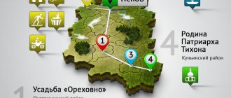
For ease of route planning, we have marked all mentioned cities and attractions on the map of the region:
Kuznetsky Alatau
The motley mountains of the Kuznetsk Alatau (from the Turkic “ala” - motley, “tau” - mountains) stretch for almost 300 km from south to north, covering Western Siberia from the south and connecting the Kemerovo region with Khakassia.
A set of ridges of medium height, the largest of which is the Old Fortress plateau with a height of 2211 m, is dissected by amazingly beautiful river valleys. The unique vegetation of this part of Siberia is represented by steppes and forest-steppes, pine and deciduous forests. Along the slopes of the mountains there is a taiga with a predominance of fir and cedar; in some places there are birch and aspen copses, smoothly flowing into subalpine meadows and ridges of the mountain tundra. Despite the exceptionally high snow cover, reaching up to 5 meters, maral, elk, roe deer, sable, musk deer and wild reindeer manage to survive here. And in the summer the brown bear fattens up for hibernation. The areas of Kuznetsk Alatau adjacent to the cities, combining pristine nature with good access roads, have long been developed by ski tourists; training camps are also held here, since the landscape allows you to choose a ski track for every taste.
Tutal Rocks
Fans of mountaineering and mountain tourism will certainly be interested in the Tutal Rocks. They were formed as a result of the washing out of shale rocks by the waters of the Tom River. Depending on the distance from the railway, tourists call them near and far. These picturesque rocks are loved by rock climbing enthusiasts. Here, tourist clubs conduct training sessions with mountaineering enthusiasts.
Mountain Shoria
In the south of the Kemerovo region there is probably the most beautiful part of this piece of Russia, namely Gornaya Shoria. It positions itself as an amazingly beautiful ski resort with developed infrastructure, located among low mountains covered with aspen and fir taiga. Particularly popular is Mount Green (Mustag) and the village of Sheregesh, which lies on its slopes, where amateur and professional Russian championships are regularly held. Before the opening of Yasnaya Polyana near Sochi, Mount Zelenaya was the main ski resort in Russia.
The Shorsky National Park was created on the territory of the region. The mountains and foothills here are covered with Siberian pine and fir; here and there you can find spruce, pine, fluffy birch and aspen. The diversity of the animal world is also great: sable, American mink, weasel, wolf, lynx, elk, otter, wolverine, wild reindeer, brown bear, musk deer, deer - this is not a complete list of animals inhabiting the local forests. Birds are represented by more than 100 species, of which the golden eagle, black stork, peregrine falcon and osprey are listed in the Red Book of the Russian Federation.
Parks, entertainment and more
Ski resort "Sheregesh"
Address: pos. Sheregesh, st. Turistskaya (Green Mountain) Website: https://www.sheregesh.su Phone: +7 933 300‑50-00, +7 3843 33‑93-33 Opening hours: 09:00-17:00
The popular ski resort in Russia Sheregesh has 15 slopes. Their length is from 700 to 5000 meters, and the elevation changes are from 120 to 630 meters.
There are several hotels and guest cottages, equipment rental, and a cafe on the territory of the complex.
On the resort's website you can find travel companions, order a transfer, and book accommodation.
Tomsk Pisanitsa
Tomsk Pisanitsa is rightfully the main historical attraction of the Kemerovo region. Tomsk Pisanitsa is an ancient sanctuary, on the rocks of which 280 rock paintings dating back to the 4th millennium BC (Neolithic) and part of the paintings from the early Iron Age were found. Petroglyphs are located on the rocks next to the Tomyu River; the drawings mainly depict hunting scenes, bears, moose, human silhouettes and solar signs.
In 1988, a museum was created on the site of the ancient sanctuary, now it is a whole museum complex which includes the Residence of the Kuzbass Father Frost, the Archeodrome - excavations of ancient burials from the Neolithic times, the Shorsky ulus Kezek - an ethnographic complex, the Museum of Asian Rock Art, a mini-zoo and the Mongolian Yurt Museum.
The Tomsk Pisanitsa museum complex is located 50 kilometers from the capital of the Kemerovo region, the city of Kemerovo, on the right bank of the Tom River.
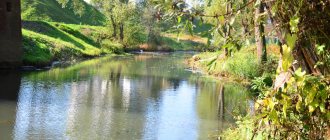
Itkarinsky waterfall
Itkarinsky waterfall - its waters cascade from one ledge of the bank of the Tom River. The water can be drunk without fear; doctors consider it mineral water, table water.
The waterfall is surrounded by a mixed forest. The guide will tell you an interesting legend about the people who previously lived on the edge of the forest where the waterfall ledge is located. There is also a parking lot for tourists.
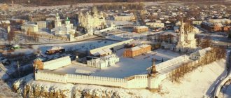
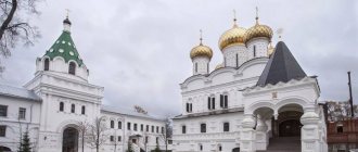
Kuznetsk Fortress
If you are in the southern capital of the Kemerovo region, the city of Novokuznetsk, then be sure to visit the main historical attraction of the south of Kuzbass, namely the Kuznetsk Fortress. The stone fortress over the Tom River began to be erected in 1799 by order of Emperor Paul I, to protect the eastern borders of the Russian Empire from the Chinese threat.
In the 2000s, the fortress was reconstructed and is now in excellent condition and houses a historical museum. In 2011, the Kuznetsk Fortress was given the status of a museum-reserve. From the territory of the Kuznetsk fortress there is a magnificent panoramic view of Novokuznetsk and its surroundings.
Cities and villages
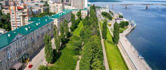
Kemerovo
The founding date of Kemerovo is considered to be 1701. The city grew out of the village of Komarovo, which was founded by the first settlers named Kemerovo. There is another explanation for the name - the Turkic word “kemer”, meaning “cliff, shore”.
The village of Shcheglov was located very close by, so during the formation of Soviet power the city bore the names Shcheglov and Shcheglovsk. It received its modern name Kemerovo in 1932.
Despite its history, the city received its status only in 1918 and developed as a Soviet mining town. Therefore, from the point of view of historical architecture, Kemerovo can only imagine buildings in the style of socialist classicism - a mixture of Empire, Gothic, and eclecticism. At the same time, the city has interesting parks, museums, sculptures and beautiful modern religious sites.
- Park of Miracles. The oldest park in Kemerovo is over 80 years old. Before the park, this place was a wasteland. Now there are many attractions, playgrounds, sculptures. Holidays are held regularly. And on weekends there is an orchestra.
- Coal Museum. The exhibitions will tell about all types of coal mined in Kuzbass. Various coal samples are displayed on display cases. Here you can learn about the stages of coal mining and processing, and the work of miners.
- Tyulbersky Nature Reserve. An ancient settlement found near Kemerovo was turned into a museum-reserve. Medieval buildings and household items are stored here; a 17th-century fort with workshops, a sacrificial altar and various outbuildings is reproduced. The reserve has natural protected areas.
- Monument to Mikhailo Volkov. The monument to the discoverer of the deposits was donated to the city in 1968 by sculptor G. Baranov. Volkov is depicted clutching a valuable find to his chest. Not far from the monument there is one of the buildings of KuzGTU.
Even more interesting places in Kemerovo in this material.
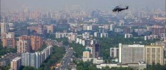
Novokuznetsk
The city appeared as the Kuznetsk fort in 1618 on the banks of the Tom River. It is considered one of the oldest cities in Siberia.
In the early years of Soviet power, Novokuznetsk became notorious for its too brutal manifestation of the “Red Terror”. Partisan Rogov killed more than seven hundred people whom he considered class enemies.
Modern Novokuznetsk is a city with developed industry. Despite the typological Stalinist development, many architectural monuments of past centuries have been preserved here.
- Transfiguration Cathedral. Its history begins with a small chapel built by the priest Anikoudimos in 1618. Construction of the stone cathedral took place from 1792 to 1835. Due to the long construction period, the style of the temple is mixed - from classical to “Siberian baroque”.
- Kuznetsk fortress. It was built on Voznesenskaya Mountain in the early 19th century as protection against a possible Chinese attack. However, she never took part in hostilities. Now the fortress houses a museum. In this room there is a collection of rare items made of silver and gold.
- House of F. M. Dostoevsky. The Literary and Historical Museum would not exist if it were not for the writer’s love for local resident Maria Isaeva. He came to Kuznetsk periodically, staying here for a total of less than a month. But Dostoevsky got married to his beloved right here, in the Church of the Virgin Mary.
Useful and interesting facts about Novokuznetsk and its attractions.
Prokopyevsk
Prokopyevsk was founded in 1651, previously bore the name of the village. Monastyrskoe. The city emerged from several nearby villages.
During the heyday of the coal industry, there were 16 mines in Prokopyevsk, but now only one operates.
The city has become home to many famous Russians. Among them: kickboxer A. Vakhitov, cosmonaut B. Volynov, hockey player S. Zinoviev, geologist A. Kontorovich and others.
- Drama Theater. The building, built in the Stalinist Empire style, is the only theater in the city. It stands at the end of a wide pedestrian street.
- Sculptures of Prokopyevsk. There are many amazing sculptural compositions in the city. For example, a monument to a plumber, Adam and Eve, an electrician.
- Cathedral of the Nativity of John the Baptist. A relatively young temple, built in memory of the dead miners. It is located in a quiet, uncrowded place - in a pine forest.
Leninsk-Kuznetsky
Until 1925, instead of the city there was the settlement of Kolchugino, known since 1759. The city was named in honor of V.I. Lenin during the life of the leader.
The city developed at the end of the 19th century, when the Success mine was opened. It turned out that on the site of the former village there are large deposits of high-quality coal.
Modern Leninsk-Kuznetsky gives the impression of a low-rise Siberian city. In the southern part, wooden buildings predominate; the city center is represented by low buildings of Stalinist classicism.
- The site of the first mine. The place where coal was first mined is located at the intersection of Furmanov and Gorky streets. The famous “Success” mine was located here. It has not been functioning for a long time. A memorial plaque has stood in its place since the 30s of the last century.
- Cinema "Victory". The first sound cinema in Siberia, it was opened in 1938. Now it is an entertainment center with cinema halls, billiards, bowling, and a cafe.
- Terrarium. It houses reptiles such as Cuban and Nile crocodiles, iguanas, and the oldest snakes in Russia - an anaconda and a boa constrictor, both 24 years old.
Celestial Teeth
Celestial Teeth (Tiger-Tysh) is one of the most beautiful mountain regions of Kuzbass, located 60 km east of the city of Mezhdurechensk. The highest peak is Verkhniy Zub (2,178 m above sea level). Located on the border of the Kemerovo region and Khakassia near the Luzhba railway station. Here you will find extraordinary beauty of nature and crystal clear air. Celestial teeth attract tourists making winter and summer hikes from all over the Kemerovo region. Many clear streams and rivers flow along the slopes of blue tarn lakes. And of course, the local aquatic fauna will not leave indifferent any person who decides to go fishing among the majestic mountain landscapes. Taimen, perch, pike, Siberian grayling - you can catch all this in the lakes and rivers of the south of the Kemerovo region.
Natural attractions
Itkarinsky waterfall
Coordinates: 55°58′02″ N. w. 84°58′46″ E. there : 2 km from the village. Itkara
The waterfall is located on the Tom River - it falls from the root ledge. Its height is 4 meters.
Above the waterfall, on the shore, there is a clearing. According to legends, peasants lived on it and had a special method of saving themselves from the raids of nomads. They built their houses in such a way that they could lower them underground at any moment: it seemed that the place was lifeless.
Not far from the waterfall is the village of Itkara, where a huge poplar tree grows (several people can grasp it) and there is a burial site according to Siberian traditions.
Tourist routes to these places with a visit to Itkarinsky are organized by Kemerovo travel agencies and various clubs.
Tutal Rocks
Coordinates: 55.713557, 84.933869 How to get there: from Kemerovo to Yurga by train, cost - 110 rubles, travel time - 3.5 hours
Tutal rocks are the bank of the Tom River opposite the city of Yurga. The official names of the rocks are Zmeinye and Nikolskiye.
This place is popular among climbers. Climbing training takes place here. There are also tourist routes.
When visiting the Snake Rocks, you must be careful - there are vipers here.
It is believed that there is an underground city under the Tutal Rocks. According to the memoirs of Tomsk local historian Loktyushin, as a child he and his friends explored the catacombs. But in the 60s, after several children were lost in the passages, the authorities decided to blow up the caves. Modern expeditions confirm the presence of underground passages.
Linden Island
Coordinates: 53.337027, 87.191838 How to get there: from Kemerovo to the village. Kuzedeevo by car 270 km, travel time - 3 hours
Linden Island is the name given to a section of forest that survived the Ice Age. In the 30s, a reserve was formed here.
Broad-leaved heat-loving lindens, which are not typical for modern Siberia, grow in a small area. It is believed that the glacier did not affect this area, so the linden trees are millions of years old. On the “island” the average air temperature is always 2-3 degrees higher than in the surrounding area.
The village of Kuzedeevo itself, next to which Lipovy Island is located, is interesting because the Vepsian people live here. In the 30s they left the Leningrad region and founded a large colony in Siberia. They speak the South Vepsian language and maintain their way of life, culture and traditions.
Royal Gate
Coordinates: 53.051094, 88.415074 How to get there: 10 km from the village. Ust-Anzas Website: https://shorskynp.ru Phone: +7 38473 3‑33-38, +7 38473 3‑33-39
The Tsar's Gate rocks are included in the Shorsky National Park. The rock is located on the banks of the Mrassu River. Its height is about 100 meters, and closer to the top there is a natural through hole in the rock. Because of him, the rock got its name.
Like many interesting natural sites, the Royal Gate is shrouded in legends. One of them tells about the brave hero Aylotai. He fought with the evil spirit Kara-Kan. He built an obstacle in the way of the hero in the form of a high powerful rock, but Aitolai’s arrow pierced the stone and hit Kara-Kan. A hole in the rock reminds of these events.
On the slopes of the upper part of the rock, primitive rock paintings have been preserved.
Gavrilovskie caves
Coordinates: 54.256934, 85.841338
Old-timers claim that before the Civil War, the length of the caves was much greater, but due to the fact that children and livestock were lost in them. Some of the passages were blown up.
Currently, the caves are relatively safe to visit on your own.
Gavrilovsky caves are two natural objects, mainly limestone. In the grottoes you can see stalactites and various rocks.
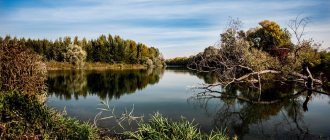
Lake Big Berchikul
Coordinates: 55.614363, 88.333165
The name of the reservoir comes from the Turkic phrase “wolf lake”. The largest lake in the Kemerovo region.
Rocks found around Berchikul indicate that there was previously an ancient sea in this place. The lake itself was also 2-3 times larger many centuries ago.
Berchikul has only one tributary, but even in the hottest summer months the water level in it does not change.
On the northern shore of the lake, mounds were found - 4 burials with the remains of 44 people, bronze items. The find dates back to the 1st-4th millennium BC.
Reserve "Kuznetsky Alatau"
Address: Mezhdurechensk, Shakhterov Ave., 33-1 Phone: +7 (38475) 5-06-11, 3-19-05 Website: https://www.kuz-alatau.ru/ Cost: 100-1000 rubles
The project to create a reserve was discussed back in the 80s. last century. However, immediate action was constantly postponed. And Siberian forests, including trees listed in the Red Book, continued to be cut down.
The reserve appeared thanks to the miners' strike in 1989. Its creation was one of the strikers' demands.
Among the unique objects of the reserve one can note: 32 small glaciers, Srednetersinskoye Lake, mountain-glacial Lake Rybnoye, the remains of ancient mountains, Krestovsky swamps.
Celestial teeth (Tiger-Tysh Ridge)
Location: 60 km from Mezhdurechensk
The mountains are located in close proximity to the Kuznetsky Alatau nature reserve, but are not part of it.
Celestial teeth are popular among mountain tourists. Therefore, there are many shelter houses where travelers can stay.
The mountain range consists of several ridges with clearly protruding mountain peaks. The highest is located on the Tiger-Tysh ridge - the Big Zub peak, more than 2 thousand meters high.
The territory contains several mountain tarn lakes, glaciers, waterfalls, rapids, and rivers.
Near the Snow Leopard shelter there is a chapel that is different from the others. The icons in it are made not in the traditional way, but in mosaics - due to the low temperatures. The chapel itself was made in parts in different cities, and then it was assembled by professional climbers.
Lake Tanay
Coordinates: 54.776170, 85.027938 How to get there: 100 km from Kemerovo to the Tanay ski complex
The shores of the lake have been considered a wonderful place to live since ancient times. Traces of people from the Stone and Bronze Ages have been found here.
By the middle of the 20th century, due to anthropogenic impact, the lake was on the verge of extinction, but it was restored in time.
Currently, crucian carp live in the reservoir, and various birds nest on the banks.
Not far from the lake there is the Tanay ski complex, where you can book a tour of the surrounding area including a visit to the lake.
Shorsky National Park
Address: Tashtagol, st. Sadovaya, 8A Phone: +7(38473) 3-33-38 Website: https://shorskynp.ru/ Opening hours: Mon-Fri 8:00-17:00
The territory of the park occupies the southern part of the Alatau-Shor Highlands.
The national park includes many karst caves and individual grottoes, the Mrassu, Pyzas, Kondoma and Kabyrzu rivers, flooded quarries and swamps.
Within the boundaries of the Shorsky Park there are several remote villages that are interesting from an ethnographic point of view. One of them is Ust-Kabyrza with a population of about 700 people. Civilization is in no hurry to enter these lands, so the village consists of wooden houses, and the residents are engaged in fishing and agriculture.
On the territory of Ust-Kabyrza, three Bronze Age sites were discovered, as well as the burial of the so-called Kabyrza princess. Coincidence or not, after the grave was opened, the harshest winter in the last hundred years came to the Kemerovo region.
Near the village there is the Azas Cave. It is believed that the yeti lives in it. Visiting the cave is possible only with permission from the Shor Park administration.
Ice mountain Mustag
Coordinates: 53°00′35″ N. w. 87°57′47″ E d.
Mustag is the highest point of Mountain Shoria. The name is translated from Shor as “ice mountain”
Currently, Mustagh is a place for alpine skiing, with ski and freeride trails, a ski lift, and a cafe.
According to legend, the mountain appeared from the Barti heroes who fought with each other. Each of them wanted to marry the beautiful Ak Puba. They did not share the girl and in the fight they turned into a mountain. Ak Puba could not stand the grief and disappeared. Every time a white cloud appears over Mustag, it is believed that Ak Puba is again mourning the heroes.
Local residents, descendants of the ancient Shors, still perform sacred rituals and pray, turning towards where Mustag stands.
Azas cave
Location: 18 km from the village. Ust-Kabyrza, Karga ulus How to get there: as part of an excursion group from the Shorsky National Park
The length of the cave is several kilometers. The Azas stream flows out of it.
There are eyewitnesses who claim to have seen Bigfoot in the cave. The existence of the Yeti has not been proven, but such rumors are spread regularly. At the same time, during the 2011 expedition, traces were found near the cave, whose identity could not be established.
You cannot visit the cave on your own. It is part of the Shorsky National Park, so it is necessary to obtain special permission.
Museum-Reserve "Krasnaya Gorka"
The museum was created as an open-air museum on the basis of historical and architectural monuments. Their administrative and residential area is located in close proximity to Gorelya Gora, where in 1721 the Russian ore explorer Mikhail Volkov discovered Kuznetsk coal. The monuments form a single thematic complex associated with the development of the Kuzbass coal industry. Each of the stages of this development left its mark in the form of immovable monuments.
During the excursion, you will be able to see with your own eyes the equipment with which coal is mined throughout the Kuzbass, this includes the Belarusian Belaz and drilling rigs, tunneling complexes with the help of which coal miners in the Kemerovo region set records, as well as a lot of geological equipment. In the basement of the museum building there is an exhibition “Mine”, demonstrating primitive methods of coal mining in Tsarist Russia. The old mines with the miners working in them have been accurately recreated. There are other exhibitions telling about the discovery and development of the Siberian coal industry.
Churches, cathedrals and temples
Holy spring in the village of Gavrilovka
Location: village. Gavrilovka Nearest town: Salair
For a long time, the source was just a spring to which a path was trodden. In 1995, the spring was consecrated, after which its arrangement began.
Now this place is a complex of a small chapel, a dressing room and a soup kitchen.
It is believed that the spring appeared after priests and parishioners were shot at this place during the Civil War. They were taken out of the church right during the liturgy.
Worship Cross
An Orthodox cross is often placed at crossroads so that a traveler can pray on a long journey. This cross is called the “Worship Cross”.
In Gornaya Shoria on Mount Kurgan at an altitude of 1555 meters , a Worship Cross was erected for the 2000th anniversary of the Birth of Christ. Together with the base (5 meters), this structure has a height of 20 meters and weighs 7.5 tons.
Mountain Shoria is a well-equipped ski resort, here you can ski, relax comfortably and see natural monuments. Vacationers have the opportunity to visit the Poklonnaya Cross by riding a snowmobile for about 20 minutes. Physically fit tourists can get to the Cross on foot along two trails. The Worship Cross attracts thousands of pilgrims every year.
Pine with rings - a botanical natural monument
In the Promyshlennovsky forestry enterprise you can see an extraordinary pine tree, which has become a botanical monument of nature. This tree attracts nature lovers with its unusual appearance. At a height of 16 meters there are unusual rings on the trunk. The tree is about 60 years old, quite healthy and without signs of pine tuberculate cancer.
Scientists suggest that while still a seedling, the pine tree suffered a tumor-like bacteriosis and, as a result, growths formed on the trunk, which are a very valuable and expensive material from which various kinds of crafts, boxes, smoking pipes, hairpins and other souvenirs are made. These products have an unusual texture.
Drama Theater of Novokuznetsk
The Drama Theater of Novokuznetsk was created in 1931. The troupe consisted of 60 people and the symphony orchestra - 15 musicians. Due to the fact that the old building was destroyed by fire, a new one with 1,200 seats . The first performance of the theater was “Intervention” by L. Slavin.
During the Second World War, the theater gave up its stage to evacuated theaters from Moscow, Ukraine and other Russian cities, and it began staging its own performances in Leninsk-Kuznetsky.
In 1963, a new building in the imperial classical style was built in Novokuznetsk. The theater is very popular not only in the Kemerovo region, but also often tours various cities of Russia and former Soviet republics.
Address: Metallurgists Avenue - 28.
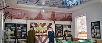
Memorial Museum of Military and Labor Glory of Kuznetsk Metallurgists (Novokuznetsk)
Metallurgists of Kuzbass made an invaluable contribution to the victory in the Second World War. In memory of their feat, a memorial museum was opened on Victory Day in 1985, in which the names of all Kuzbass metallurgists who gave their lives during the Second World War are engraved on memorial plates.
The Eternal Flame also burns here, lit from the open-hearth furnace that produced the first steel for armor in 1941.
The museum has collected more than 2,500 exhibits telling about the life and struggle of metallurgists. Excursions here are conducted with musical accompaniment; the original voice of Levitan sounds, announcing the beginning of the war and Victory. This evokes deeper emotional feelings about wartime.
Address: Pobedy Square - 1/1.