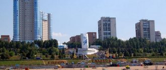
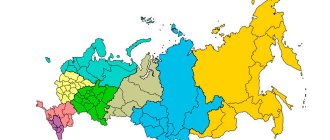
Zhigulevsk is one of the cities of the Volga region and Samara region. It is located on the Zhiguli Mountains on the right bank of the Volga - in its middle reaches. The city was founded in 1949. Zhigulevsk is located 96 km northwest of Samara and 969 km southeast of Moscow.
The area of the city is 60.8 km2. The population of Zhigulevsk is 54,343 people. Time in the city of Zhigulevsk is one hour ahead of Moscow.
City `s history
Since the seventeenth century, on the site of present-day Zhigulevsk there were the villages of Morkvashi and Otvazhnoe. The city was built during the Soviet era, and the builders were prisoners. Oil production began, a hydroelectric power station, a cement plant and three limestone quarries were built.
Thanks to the boxing school built in the city, local athletes managed to become winners of world championships and Olympics.
In the eighties, the Samarskaya Luka National Park was formed in the vicinity of Zhigulevsk. In 2006, the Zhigulevsky Nature Reserve became a reserve.
The urban district of Zhigulevsk with a population of more than 58 thousand people includes the villages of Shiryaevo, Bakhilova Polyana, Zolnoye, Bogatyr, Solnechnaya Polyana.
Shiryaevo is a village on the right bank of the Volga within the Zhigulevsky Nature Reserve in a wide valley near the Zhigulevsky Mountains. Since January 1, 2006, it has been part of the Zhigulevsk urban district.
The first mention of the village of Shiryaevo in historical documents dates back to 1643-1645. A description of the surroundings of the village in Zhiguli can be found in the notes of the Dutch painter and traveler Cornelius de Bruin, who saw these places in May 1703. His book contains the lines: “At 9 o’clock, turning to the southwest, we noticed a plain on the right between high mountains, and then a village lying 20 versts from Samara. Our people went there for food, and the river in this place was very wide.” The sources also refer to Shiryaev Buerak, the village of Shiryaeva, Shiryaevka, the village of Shiryaevskoye, the village of Bogoyavlenskoye.
The original name of the village - Shiryaev Buerak - is associated with the size of the valley in which the village is located. “Shirai” means “width”, “space”; "Gully" - ravine. Shiryaevsky ravine is the largest such formation in Samara Luka, its length is about 35 km. Perhaps the toponym comes from a personal name - “Shirai”
A museum complex was formed in Shiryavo consisting of the Repin house-museum, the Shiryaevets house-museum and the Vdovin estate. The opening of the complex took place on June 12, 2007. A monument to Repin, an ethnographic exhibition, a poetry platform, and new exhibition halls appeared in Shiryaevo.
Bakhilova Polyana is a settlement that is part of the Zhigulevsk urban district. It was formed during the construction of the Volzhskaya Hydroelectric Power Station.
In the village there was a timber industry enterprise - a wood processing base, and the former pioneer camp "Zhigulevsky Artek".
Solnechnaya Polyana is a village in the urban district of Zhigulevsk.
The village is located on the northern edge of Samarskaya Luka, on the banks of the Saratov Volga reservoir.
The population is about 2 thousand people. The village consists of 30 streets.
Zolnoye is a village (until 2004 - an urban-type settlement), part of the Zhigulevsk urban district of the Samara region. Formed in the middle of the 20th century as a result of the discovery of an oil field in the Zhiguli Mountains.
The village is located in the picturesque places of Samarskaya Luka.
Bogatyr is a village (formerly an urban settlement) in the urban district of Zhigulevsk, Samara region.
It is located below Zhigulevsk, Bakhilova Polyana and Zolny along the Volga. The village is home to one of three limestone quarries in Zhigulevsk. There is a river pier.
Transport and industry
The city has enterprises in the food, pharmaceutical, military, mining and electric power industries. Previously, there was also an oil-extracting industry, which was practically curtailed due to the depletion of oil reserves. In the energy sector, there is the Zhigulevskaya hydroelectric power station.
The city is crossed by the Ural federal highway. There is a city bus station - buses depart from there to Ulyanovsk, Penza, Samara, Kuznetsk, Dimitrovgrad, Syzran.
Cities
City Zhigulevsk
- a city in the Samara region of the Russian Federation, located on the right bank of the middle Volga in the northern part of the Samarskaya Luka National Park in the valleys of the Zhiguli Mountains. Population - 57.6 thousand people. with settlements subordinate to the Zhigulevsk administration as of the end of 2011. The federal highway M5 Moscow-Chelyabinsk passes through Zhigulevsk. The distance from the city bus station to Samara along the highway is 96 km, to Moscow - 969 km. There is a railway connection along the line “Tolyatti-Zhigulevskoye Sea-Syzran-Moscow”. In 1991-2008 The head of the city was Sergei Balakhonov. After his departure, two main local forces claimed this post: Nikolai Radaikin, chairman of the Zhigulevsk Duma, and the famous businessman Maxim Borodin, general director of Zhigulevskoye Quarry Management CJSC. The Governor of the Samara Region, Vladimir Artyakov, recommended the Tolyatti businessman, owner of the Ton-Auto group, Alexander Kurylin, who at that time held the position of First Deputy Mayor of the city of Tolyatti. In 2008, Alexander Kurylin was elected head of Zhigulevsk.
Education in the city of
Zhigulevsk
The city has a number of secondary specialized and general educational institutions. There are no higher vocational educational institutions in the city, so future students go to other cities to enroll.
Economy of
the city of Zhigulevsk
Electric power industry Zhigulevskaya HPP, a branch of JSC RusHydro Oil production industry - practically curtailed due to the extraction of oil reserves Mechanical engineering Battery plant AKOM Extraction and production of building materials Zhigulevskaya building materials, a branch of Eurocement group JSC Zhigulevskoe quarry management.
Food Confectionery plant USLADA Zhigulevsky bakery Pharmaceutical industry Zhigulevsky pharmaceutical plant LLC Ozon Military-industrial complex enterprises
History of the city of
Zhigulevsk
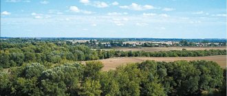
The name of the city comes from the Zhigulevsky Mountains (or Zhiguli) hills, surrounded by which it is located. The city was formed by the Decree of the Presidium of the Supreme Soviet of the RSFSR dated February 21, 1952 as a result of the transformation of the workers' village of Zhigulevsk. It borders with the city of Togliatti and the Stavropol district of the Samara region. On January 1, 2006, a municipal entity was created - the urban district of Zhigulevsk. The urban district of Zhigulevsk includes the city of Zhigulevsk and the villages of Bakhilova Polyana, Zolnoye, Solnechnaya Polyana, Bogatyr and Shiryaevo. These villages, a narrow strip stretching 25 km downstream of the right bank of the Volga River, are located in the most picturesque places of the Samara Luka. 5 km above Zhigulevsk along the Volga River, on its right bank there is a microdistrict (formerly an urban-type settlement) Yablonevyi Ovrag, also part of the urban district. Since the 17th century, on the site of Zhigulevsk there were the villages of Morkvashi and Otvazhnoe. In 1942, oil from the Devonian period was discovered in the area of Apple Ravine, located within the city. Oil was found in other places of the Samara Luka. In the early 1950s, construction began in the city area of the Volzhskaya Hydroelectric Power Station, the largest in the world at the time of commissioning. V.I. Lenin (now the Zhigulevskaya HPP), which was completed in 1957. In 1950-1960 A large cement plant was built in the village of Yablonevyi Ovrag. The construction of the city, hydroelectric power station and cement production was carried out by the NKVD. Many correctional camps were located on the territory, which were disbanded after construction was completed. For the grandiose construction, three limestone quarries were laid for the extraction of Zhiguli rocks. Open-pit mining continues to this day, causing enormous damage to this unique corner of nature. In the mid-80s of the 20th century, the Samarskaya Luka State National Park was formed, under whose jurisdiction the reclaimed parts of the quarries are transferred. In August 2006, the entire territory of Samarskaya Luka, the Zhigulevsky Nature Reserve, the green zone in the city of Togliatti and other nearby territories were declared a biological reserve by UNESCO. The close location to Togliatti (formally the cities are adjacent to each other, in practice they are separated by a dam across the Volga and a hydroelectric power station) determines the economic and social ties of the city. Zhigulevsk is famous for its athletes. The city has a strong boxing school; its representatives have repeatedly become champions of the world, Europe, Russia and the Olympic Games.
| Coat of arms citiesZhigulevsk -In the silver field in front of the green rock shifted to the right there is azure water with a large wave running to the right, the crest of which at the head of the shield turns into a firebird flying down and turning to the left. Rationale for symbolism: The composition of the coat of arms is based on the special geographical location of the city of Zhigulevsk on the banks of the Volga River in the picturesque valley of the natural and cultural complex of Samarskaya Luka, surrounded by the Zhigulevsk Mountains. Samarskaya Luka is a unique complex of living nature with unique relief forms, a unique microclimate, the presence of interesting geological formations, natural and historical monuments. The city arose on the site of the villages of Otvazhnoe (known since 1840) and Morkvashi (known since 1647) in connection with the development of oil fields. The Firebird has multi-valued symbolism: - the fabulous beauty of the Volga River, forests, mountains; - a symbol of good luck, a high goal in life, perfection; - the tail of the firebird wraps around the mountainside - this is the symbolic “main street” of the city - the great Russian river Volga has formed a bend among the Zhiguli Mountains on the Tolyatti-Samara-Syzran section. The mountain symbolizes confidence, stability, immutability, indestructibility. Green color complements the symbolism of nature surrounding the city, and this color also symbolizes life, health, prosperity, stability. Modern Zhigulevsk is a city of oil workers, energy workers, and builders. The main asset of the city has been and remains its people - friendly and enterprising, talented and business-minded, creating material and spiritual values. The hearts of Zhiguli residents are open to guests and good friends. Silver is a symbol of simplicity, perfection, wisdom, nobility, peace and mutual cooperation. Author group: idea of the coat of arms: Mikhail Vaganov (Zheleznodorodny), Konstantin Mochenov (Khimki); rationale for symbolism: Galina Tunik (Moscow); artist and computer design: Galina Rusanova (Moscow). Approved by the resolution of the City Duma of the city of Zhigulevsk (#39) dated December 29, 2003. | Flag citiesZhigulevsk— A rectangular panel with a width to length ratio of 2:3, reproducing the coat of arms composition: along the lower side of the panel in front of the green rock, shifted towards the shaft, there are blue waves rising towards the edges of the panel, the crest of which above the rock turns into a firebird flying down and turning to the right. Approved by resolution of the City Duma dated 02/05/2004 #07. |
Population of the city of Zhigulevsk
In 2021, the number of residents of the city of Zhigulevsk was 54,343 people. Since 1959, when systematic data became available, the population has not shown any directional dynamics. Moreover, in the nineties it grew, which is not typical for Russian cities.
Since 2005, the population of Zhigulevsk has remained virtually unchanged. The largest number of residents was in 2008, when the city's population was 57,100 people. A notable decline occurred from 2021 to 2021. The number of residents of Zhigulevsk is greatly influenced by migration.
In 2021, Zhigulevsk was in 304th place among the cities of the Russian Federation in terms of population. The predominance of older age groups is typical, and over time it only increases.
The population density is 894 people per km2. Information on the population is provided by the Rosstat service and EMISS.
Residents of the city are called Zhiguli residents.
Zhigulevsk
The first settlements on the territory of modern Zhigulevsk appeared in the 10th century. The city arose on the land on which the villages of Morkvashi and Otvazhnoe were located. The village of Otvazhnoe had to be moved due to the construction of the Kuibyshev hydroelectric power station. The settlement fell into a flood zone. Between the villages of Shiryaevo and Podgory, the Serny town was built by order of Peter I in 1720. Not far from these places, sulfur was mined, which was supposed to be processed in Sulfur Town. Sulfur was needed for military needs. In the second half of the 19th century, tar and asphalt plants operated near the village of Bakhilova Polyana. The asphalt produced here was considered the best in Europe. In addition, it was cheaper in price. In 1859, in the vicinity of the village of Shiryaev Buerak, a quarry appeared, engaged in the extraction and roasting of limestone. Initially, the quarry belonged to Prince Volkonsky, then it passed to a Samara merchant named Nazarov. After changing several more owners, the quarry finally went to the rich peasant Vanyushin in 1900. The limestone mined in local quarries was considered one of the highest quality in the country. Local limestone was used in the construction of houses in Balakov, Samara and Saratov. The quality of the building material was noted in 1905 and 1906 at exhibitions in the Belgian city of Liege.
The mill industry also developed in the village of Otvazhnoe. The first mill was built in 1880. At the end of the 19th century, Count Orlov-Davydov settled in Bakhilova Polyana. On his order, a narrow-gauge railway was built to transport timber from the most remote corners of the forest. Wood was considered an important strategic and technological raw material.
In the 30s of the twentieth century, not far from modern Zhigulevsk, geologists were looking for oil. The search turned out to be successful, despite the fact that it took more than one year to search. At the end of 1937, the first well was found in Yablonevoy Ravine. The search for oil and the development of new wells did not stop even during the Great Patriotic War. A huge number of specialists arrived to develop new wells. This is how the working settlement of Zhigulevsk appeared. At the end of February 1952, the workers' settlement received city status. The city (and previously the village) received its name from the Zhiguli Mountains, otherwise called Zhiguli. The Zhiguli Mountains are considered a historical place. The freemen of Razin and Pugachev were located in these mountains. History reminds itself in the names of geographical objects: Molodetsky Kurgan, Vorovskoy Ravine, Sheludyak Cliff.
The construction of the city and the construction of cement production were organized with the participation of the NKVD forces. Correctional camps were located in the vicinity of the city. After construction was completed they were disbanded. A lot of material was required for construction, so the management decided to establish 3 limestone quarries for the extraction of Zhiguli rocks. Mining was carried out using the open-pit method, which is still used to this day, which causes considerable harm to nature. In the 80s of the twentieth century, the State National Park was founded, called “Samarskaya Luka”. Reclaimed parts of quarries come under the jurisdiction of this park. In 2006, the park and some other nearby areas were declared a biological reserve by UNESCO.
At the beginning of the twentieth century, Morkvashi was a fairly large village. There were at least 125 households here. The city itself had about five thousand houses. The first city development project was developed in 1961 at the Leningrad Institute Lengorproekt. In the early 90s, a new plan was created, which was supposed to be implemented within thirty years. In 1995, a new concept for the city's development was developed. According to this concept, Zhigulevsk should develop in two main directions. First of all, the city should become a center of eco-tourism in its region. The infrastructure of Zhigulevsk must meet international standards. Secondly, Zhigulevsk should receive the status of an industrial center. To achieve this, it is not enough to simply build a huge number of factories in the city and its environs. It is important to equip enterprises with high-tech equipment and take care of environmental safety.
In 2006, a municipal formation appeared, called the Zhigulevsk urban district. The district included Zhigulevsk itself, as well as the largest settlements in this area - the villages of Zolnoye, Bogatyr, Solnechnaya Polyana, Bakhilova Polyana and Shiryaevo. In addition, the microdistrict (former urban-type settlement) Yablonevyi Ovrag became part of the city. The territory of the district is something similar to an archipelago, as the local residents themselves say. The municipality stretches for 60 kilometers along the banks of the Volga.
The city of Zhigulevsk became widely known in Europe thanks to Adam Olearius, a German traveler who visited the city. Olearius described his travel report in his book. Russians also wrote about the city: S. Skitalets, M. Gorky and others. In their books they described not only real historical facts from the history of the city, but also numerous folk legends and tales.
The development of modern Zhigulevsk is determined by the availability of mineral, raw materials and fuel and energy resources. The central place in the Volga-Kama cascade is occupied by the Volzhskaya HPP named after V.I. Lenin. Oil production has been carried out in the vicinity of Zhigulevsk for more than half a century. The Zhiguli Mountains are considered a unique open-air museum-reserve. The city has not only industrial, but also tourism prospects. Over the past 20 years, Zhigulevsk has changed significantly. Many new enterprises were built here. The products of the Uslada confectionery plant are known far beyond the borders of the district. Among the city's popular products one can also name the famous Zhiguli beer. Construction companies, the service sector and enterprises producing medicines are successfully developing.