| Kalmykia |
Kalmykia
, a republic in Russia. It is part of the Southern Federal District and is part of the Volga economic region. The capital is Elista. It is located in the extreme southeast of the European part of Russia, in the southeast it is washed by the Caspian Sea. It borders: in the south - with the Republic of Dagestan, in the southwest - with the Stavropol Territory, in the west - with the Rostov Region, in the northwest - with the Volgograd Region, in the east - with the Astrakhan Region. Territory area 74.7 thousand square meters. km, population 275.4 thousand people. (2018). Official languages: Kalmyk and Russian
- On the map: Yandex.Map, Google map
The ancestors of the Kalmyks - the Oirats (Western Mongols), who lived in Central Asia (Dzungaria and neighboring regions), split up at the end of the 16th - beginning of the 17th centuries, some of the Oirats moved through Southern and Western Siberia to the Lower Volga and the Northern Caspian Sea, where they settled in the first third XVII century, displacing the Nogais from there.
In the process of resettlement, the Western Mongols formed into a separate ethnic group - the Kalmyks. In the middle of the 17th century, the Kalmyks finally established themselves in the west of the Great Steppe, partly subjugating and partly displacing the nomadic nomads of the Greater and Lesser Nogais to the Crimea and the Caucasus. The nomadic pastures of the Kalmyk tribes in the Lower Volga and in the Northern Caspian region occupied the territory in the south to the Terek, in the north to the city of Samara, in the west to the river. Don and in the east to the river. Yaik (Ural); later, the area of residence decreased and roughly corresponded to the borders of modern Kalmykia. The first ruler of the Kalmyk (Torgout) Khanate formed in the Lower Volga (existed in 1633-1771) was Taisha Kho-Urlyuk (1633-1644). The Khanate was divided into uluses governed by noyons; the uluses consisted of aimaks and khotons, subordinate to the zaisangs. The Khanate reached its peak during the reign of Ayuki (1672-1724). Kalmyks found themselves on the territory of the Russian state at the beginning of the 17th century. In 1608, Tsar Vasily Shuisky received one of the first Kalmyk embassies and agreed to the request for the Kalmyks to accept Russian citizenship. In 1655, the Kalmyks gave the first shert record (oath of allegiance) to the Russian Tsar (subsequently, the Kalmyks repeatedly gave sherts and violated them).
From the second half of the 17th century, at the request of the Russian government, Kalmyks took part in military campaigns. While maintaining loyalty to Russia, the Kalmyk khans pursued an independent policy in the 17th and first half of the 18th centuries. During the reign of Ayuki, the Kalmyks and the Tatars under their control often attacked Russian villages. In 1684, Ayuka suffered hostilities beyond the Urals: he fought with the Kyrgyz-Kaisaks, then conquered the Mangyshlak Turkmens; His wars with the North Caucasian peoples date back to the same period. In the 17th-18th centuries, the Kalmyk Khanate maintained constant contact with other Mongol states. In the 17th century, despite treaties of dependence on Russia, the Kalmyk khans received approval of their status from the Dalai Lama.
After the death of Ayuki (1724), the Russian government established the practice of directly appointing the ruler of the Kalmyk Khanate in the status of governor. In 1732-1734, the population of a number of uluses that did not submit to the new khan migrated to Kuban. In the middle of the 18th century, the governor of the Kalmyk Khanate was included in the management system of the Astrakhan province; in 1762, a reform of the traditional judicial-administrative body of the Kalmyks - zargo - was carried out, as a result of which the judicial and political power of the khan (governor) decreased.
In January 1771, almost three-quarters of the Kalmyks (about 150 thousand people), led by Khan Ubashi, left Russia for territories controlled by China, half of those who migrated reached their destination, and all the livestock was lost. There are approx. left on the Volga. 55 thousand people The reason for the resettlement was the dissatisfaction of many Kalmyk noyons with the amount of military booty, which was a traditional source of wealth, as well as with the Christianization of Kalmyks carried out by the Russian government and the colonization of nomadic places. By decree of Empress Catherine II Alekseevna of October 19, 1771, the Kalmyk Khanate was liquidated, its territory, as an autonomous entity, the Kalmyk steppe, became part of the Astrakhan province.
On March 10, 1825, “Rules for the management of the Kalmyk people” were published, according to which Kalmyk affairs were transferred from the Ministry of Foreign Affairs to the Ministry of Internal Affairs of the Russian Empire. In the second half of the 19th century, the Kalmyk steppe was divided into uluses: Maloderbetovsky, Manychsky, Aleksandrovsky (Khosheutovsky), Bagatsokhurovsky, Ikitsohurovsky, Kharakhusovsky, Yandyko-Mochazhny, Erketenevsky, Bolshederbetovsky (in 1860 it became part of the Stavropol province).
After the October Revolution of 1917, some Kalmyks joined the Astrakhan Cossack Army. In the summer-autumn of 1919, most of the Kalmyk settlement area came under the control of white troops; by March 1920, Soviet power was established here.
In July 1920, an autonomous region of the Kalmyk working people was formed as part of the RSFSR with its center in Astrakhan (since 1926, the center has been Elista). In 1926, an alphabet based on the Cyrillic alphabet was introduced everywhere.
On October 20, 1935, the autonomous region was transformed into the Kalmyk Autonomous Soviet Socialist Republic.
In the 1930s, radical socio-economic and cultural reforms began in the republic, associated with the final transition from a nomadic to a settled way of life.
During the Great Patriotic War from August 1942 to January 1943, a significant part of the Kalmyk Autonomous Soviet Socialist Republic was occupied by German troops and liberated during the Red Army counteroffensive near Stalingrad.
On December 27, 1943, as a result of accusations against Kalmyks of collaboration, the Kalmyk Autonomous Soviet Socialist Republic was abolished, its territory was transferred to the formed Astrakhan region (eight districts), as well as the Stavropol Territory, Stalingrad and Rostov regions. The city of Elista was renamed Stepnoy, more than 92 thousand people were deported to Siberia, Central Asia and Kazakhstan.
On January 9, 1957, by decree of the Presidium of the Supreme Soviet of the USSR, the autonomy of Kalmykia was restored and the Kalmyk Autonomous Region was formed as part of the Stavropol Territory. In July 1958, the region was transformed into the Kalmyk Autonomous Soviet Socialist Republic; the territory of the Dolbansky and Volga uluses of the former Kalmyk Autonomous Soviet Socialist Republic remained in the Astrakhan region.
In 1957-1959, over 72.6 thousand Kalmyks returned to their native lands. During the years of the Soviet five-year plans, agriculture and industry developed intensively in Kalmykia.
In 1959-1965, 22 enterprises were built in the republic, including the Caspian Machine-Building Plant, knitting and clothing factories. In 1970, an airport was opened in Elista.
In October 1990, the Kalmyk SSR was proclaimed as part of the RSFSR.
In February 1992, the republic received its modern name.
On April 5, 1994, the Steppe Code (Constitution) of the Republic of Kalmykia was adopted.
History of Kalmykia and Kalmyks
The history of the Kalmyks as a people begins at the end of the 16th century, when the Oirat tribes were divided into three parts, one of which moved from Central Asia to the territory of the modern Republic of Kalmykia, where it consolidated within Russia in 1609.
The first time was accompanied by frequent wars, including internecine wars, changes in borders and nomadic movements. Kalmyks periodically swear allegiance to Russia, but often violate agreements by attacking Russians. But around the end of the 18th century, a quiet life began as part of Russia.
In 1917, the so-called Steppe Region of the Kalmyk people was formed, and in 1920 - the Kalmyk Autonomous Region, which 15 years later was transformed into the Kalmyk Autonomous Soviet Socialist Republic.
1943 was one of the darkest years in the history of the Kalmyks - the Kalmyk Autonomous Soviet Socialist Republic was abolished, its territory was transferred to the Astrakhan region, and almost all Kalmyks were deported (mainly to Siberia).
Only 14 years later did the Kalmyks return to their homeland, and in 1958 the Kalmyk Autonomous Soviet Socialist Republic was restored, which in 1992 was renamed the Republic of Kalmykia.
Geography and climate of Kalmykia
The Republic of Kalmykia has many neighbors, in the south there are the Stavropol Territory and the Republic of Dagestan, in the east there is the Astrakhan region, in the west there is the Rostov region, and in the north there is the Volgograd region. Part of the southeastern territory is washed by the Caspian Sea.
The flat territory of the region is mainly covered with endless steppes, semi-deserts and deserts.
The Caspian Sea is not the only water resource of the republic. In one of the places, Kalmykia, with a narrow ledge, opens up to the Volga - there is the city of Tsagan Aman, in addition to this, the Kuma and Manych rivers flow on the territory of the republic. There are also lakes on the territory of Kalmykia: Lake Manych-Gudilo, Sarpinsky Lakes, Yashalta Salt Lake and Sostinsky Lakes.
The climate of the Republic of Kalmykia is sharply continental. Its features are hot and dry summers, as well as little snow and not the coldest winters (although sometimes the temperature in winter drops significantly). In addition to low precipitation and aridity, a feature of the climate is constant winds.
Features of Elista
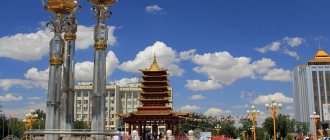
The unofficial name of the city sounds like the Buddhist capital of Russia. Some sources contain information that applies to all of Europe. This is due to the fact that Elista has a large number of different pagodas, Buddha statues and prayer stupas. Even the Dalai Lama himself often visited Kalmyk temples.
Another distinctive feature of the city is chess and all the interesting traditions associated with this sport. They were instilled in the population by the first president of Kalmykia, Kirsan Ilyumzhinov. To leave a mark in history, the Chess City was built here, in which a monument to the famous Ostap Bender was erected. Elista is home to many different sculptures, statues, pedestals and monuments. Each creation is distinguished by its beauty, history, grace, as well as a unique idea. Here you can easily find new European sculptures and Buddhist statues nearby. The city authorities take care of their safety and that they form a single interesting ensemble.
Thanks to these efforts, the appearance of the city becomes interesting and memorable for both local residents and visiting guests, who never cease to be amazed by the unusual, and sometimes even funny, architecture.
Elista is located in the same time zone as the capital of Russia. The city covers an area of 93 square meters and accommodates a population of more than 100 thousand people. There are various peoples and nationalities here. The overwhelming majority of people living in this area are Russians and Kalmyks. There are also several types of religions in this territory, but Buddhism remains the most widespread.
The capital of Kalmykia has a steppe and sharply continental climate. Therefore, there is little precipitation throughout the year, and the average temperature throughout the country reaches 8 degrees. Humidity is at 20%, the air is dry. Summer in Elista is very hot and lasts relatively long. With the arrival of autumn, the rains begin to fall. During this period, the steppe begins to come to life. Winter in the city does not last long. A distinctive feature of this time of year are the winds, which constantly change their direction. With the arrival of spring, the entire area is covered with beautiful blooming tulips.
Nature of Kalmykia
In the Republic of Kalmykia there are practically no forests and most of the fauna and flora are steppe representatives.
First of all, among them it is worth noting various rodents (gophers, marmots) and saigas, for the protection of which the Black Lands Nature Reserve was created. In addition to them, you can find brown hares, hedgehogs, jerboas and corsacs here. The flora here is represented by truly steppe and desert plants: feather grass, wormwood, camel thorn, cornflowers and Schrenk's tulips.
The second section of this reserve - Lake Manych-Gudilo - also protects numerous populations of various birds: pelicans, swans, greylag geese, bustards, cranes, gulls, swallows and others.
Population and economy of Kalmykia
There are three cities in the republic: Elista, Lagan and Gorodovikovsk and 13 administrative districts. The total population is less than 300 thousand people. As you would expect, the majority of the population is Kalmyks, and there are also many Russians. Other nationalities are also represented, mainly residents of other southern republics.
The economy of the Republic of Kalmykia is poorly developed, industry is mainly concentrated in the extraction of minerals (oil and natural gas), there is mechanical engineering, metalworking and the production of building materials.
The rural population is engaged in the cultivation of grain crops, vegetables and melons, as well as animal husbandry and wool production.
Republic of the Russian Federation
Until 2014, there were 21 republics in Russia. After reunification with Crimea, there were 22 of them. All subjects have equal rights and can officially approve a second language and their own republican symbols.
By their status, republics secure the integrity of the territories. May have features in economics and politics. At the same time, the rules, laws, and activities of the republic cannot contradict the legislation of the Russian Federation.
List of republics
The republics of Russia are located in five federal districts. They all have different cultures, sizes of territories, histories. But each such subject has the same rights, freedoms and obligations. Most of them appeared under the USSR.
| Republic | Capital Cities | Languages (besides Russian) |
| Adygea | Maykop | Adyghe |
| Altai | Gorno-Altaisk | Altaic |
| Bashkortostan | Ufa | Bashkir |
| Buryatia | Ulan-Ude | Buryat |
| Dagestan | Makhachkala | Avar, Agul, Dargin, Chechen, Tabasaran, Azerbaijani and others |
| Ingushetia | Magas | Ingush |
| Kabardino-Balkaria | Nalchik | Balkar, Kabardian |
| Kalmykia | Elista | Kalmyk |
| Karachay-Cherkessia | Cherkessk | Karachay, Circassian, Nogai, Abaza |
| Karelia | Petrozavodsk | Karelian |
| Komi | Syktyvkar | Komi |
| Mari El | Yoshkar-Ola | Mari |
| Mordovia | Saransk | Mordovian |
| Sakha (Yakutia) | Yakutsk | Yakut |
| North Ossetia Alania | Vladikavkaz | Ossetian |
| Tatarstan | Kazan | Tatar |
| Tyva | Kyzyl | Tuvan |
| Udmurtia | Izhevsk | Udmurt |
| Khakassia | Abakan | Khakassian |
| Chechnya | Grozny | Chechen |
| Chuvashia | Cheboksary | Chuvash |
| Crimea | Simferopol | Crimean Tatar, Ukrainian |
Each subject is enormous in its significance for Russia.
Yakutia covers 1/6 part (more than 3 million km2) of the entire territory of the Russian Federation. If you look at the map, you can see that approximately 40% of its area is located beyond the Arctic Circle. A sparsely populated area due to the climatic characteristics of the region, less than a million people live in the republic.
But economically, Yakutia is one of the ten richest territories in the country (ranked 9th). A huge amount of mineral resources allows the republic to exist safely, regardless of the level of federal funding. Citizens living in Yakutia receive high incomes.
By the way, the remains of mammoths are regularly found here.
Yakutia is the largest subject in Russia by area, and the smallest is Ingushetia - 3628 km2. But in terms of density, Ingushetia ranks fifth in the country. Chechnya and North Ossetia are also densely populated regions.
Dagestan is considered the poorest republic. Industry is poorly developed here, sources of minerals are scarce, and the land is not particularly productive or suitable for farming.
Altai is considered the second Switzerland. There is very beautiful, rich nature, great cultural heritage, and a well-developed tourism industry. Bashkortostan, or more precisely the city of Ufa, is the largest oil refining center. There are also many sanatoriums, recreation centers, and hospitals in the republic.
The local nature is conducive to relaxation and treatment. There are many nature reserves and forest areas. Forests occupy 40% of the area of Bashkortostan. The mufti of the Spiritual Administration of Russian Muslims and believers from some CIS countries is in Ufa.
Karelia is one of the main tourist centers of the country. The nature here is gorgeous and there are many interesting monuments. Fishing and hunting are excellent. The unforgettable beauty of the White Sea, lakes and rivers. In addition to the tourism industry, Karelia is known for its efficiently operating industry - paper and wood processing, production of building materials, forestry and mining.
Crimea joined Russia in 2014 after a referendum. Most of the population supported a return to Russian roots. Since then, the Crimean Republic has been a subject of the Russian Federation and its main tourist center.
After reunification with Russia, a new Constitution, new authorities, and republican symbols were established in Crimea. Now Crimea is the most subsidized region of the Russian Federation, financing occurs at the level of tens of billions of rubles annually.
Culture and religion of Kalmykia
Kalmyks have a very interesting and distinctive culture associated with their Asian roots. Religion is also unusual for Russia; the Republic of Kalmykia is one of three regions where Buddhism is preached. Moreover, what is interesting is that the pagan beliefs of the Kalmyks are closely intertwined with Buddhism, not contradicting the teachings of Buddha, but, on the contrary, complementing it.
The Kalmyks also have their own folklore and epic - “Dzhangar”, where the poems tell about the land of the immortals and its inhabitants, powerful heroes. Dzhangarchi (as those who performed folk songs were called) have always enjoyed enormous popularity among the people. But even now the Kalmyks do not forget their culture: in Elista there are many monuments dedicated to the heroes of “Dzhangar”: the Golden Horseman, the monument to Dzhangar, Khongor (heroes of the epic) and other sculptural images.
Kalmykia
There are only 3 cities and 260 rural settlements in Kalmykia. This indicator of settlements relative to area is one of the lowest in Russia. At the same time, many settlements have retained their identity and ancient traditions. Interesting tourist areas are located at a decent distance from each other; the underdeveloped transport network also adds to the complexity of building a route. To visit as many attractions as possible in Kalmykia, allow at least 1 week for your trip.
Elista
The capital of the Republic of Kalmykia is the spiritual Buddhist center of Europe. The city was founded in 1865. Elista got its name from the river in which the city is located. The name is based on the Kalmyk root “elsen”, which means “sand, sandy”. Before the formation of the settlement, nomadic Kalmyks stopped in the Elista gully.
Golden Abode of Buddha Shakyamuni
© Igor Butyrskii
The capital of Kalmykia suffered greatly during the war years. Few pre-revolutionary architectural monuments have survived in the city. The oldest building in Elista is the Church of the Exaltation of the Cross, which was erected in 1879. But the main religious attractions are the Buddhist temples. Colorful pagodas and stupas, gilded statues and gates create the feeling of a journey to Tibet.
Despite all the Asian flavor, you can still find a corner of Europe in Elista. This is the “City of Chess”, built in Elista for the World Chess Olympiad. Here you can take funny photos with huge chess pieces and visit the Chess Palace with a museum dedicated to this board game. Other interesting museums in Elista include: the National Museum of the Republic with objects of Old Kalmyk art, the Museum of the History of Buddhism, the Museum of Fine Arts and the Oirat Museum, dedicated to the Mongolian culture of nomads.
Fans of cultural events will also not be bored in Elista. There are 3 theaters in the capital of the republic, where you can see not only classical productions, but also performances based on the Kalmyk epic and Buddhist works. What else to do in Elista? Take a walk looking for unusual sculptures and monuments - try to find on the city streets a monument to the last Kalmyk khan, the owner of the steppe - a camel and the hero of the folklore epic "Dzhangar" - the "Golden Horseman".
Information about Elista Stories and reviews from tourists
Lagan
The second largest city of the Republic of Kalmykia is called the Caspian capital. Lagan is located 300 km from Elista, on the northwestern coast of the Caspian Sea, near the Volga and Astrakhan delta. The settlement, founded in 1871, was named after the island of the same name, on which the first settlements in the area appeared. The name comes from the Kalmyk word “la” - the name given to muddy swamps. The sea coast here is marshy, sandy lagoons are prone to flooding. Now Lagan Island no longer exists - it has become part of the “mainland”.
Lotus Valley in the Volga Delta
© Elena Senina
The village on the shores of the Caspian Sea was founded by peasant migrants from Central Russia. Before this, several families of nomadic Kalmyks and fishermen lived on the island. In 1873, the first temple was erected on Lagan - St. Nicholas the Pleasant, who is the patron saint of sailors. The first fishing enterprise on Lagan was founded in 1885. Such benefits of civilization as mail and telegraph appeared only at the beginning of the 20th century. In Soviet times, Lagan became a workers' village, the main enterprise was the fishing collective farm "Kaspiets". In 1944, the village was renamed Kaspiysky; the old name returned only after the collapse of the USSR. Lagan received city status in 1963, when the Caspian Machine-Building Plant was opened here.
Lagan is located 9 km from the Caspian Sea. The city is connected to the reservoir by a 10 km long shipping canal. Lagan is notable for its system of canals and reservoirs, which serve as a river network. There are fishing houses on the canals - tourists come here on weekends. The bite on the Lagan canals is excellent. Pike, carp, rudd and perch are caught here.
The romance of the fishing settlement is contrasted by religious monuments. The main attraction of the city is the Lagansky Khurul, a Buddhist temple built with funds donated by the Dalai Lama himself. The architecture of the city is mainly one-story wooden houses. In Lagan, it is also worth visiting the colorful market and trying homemade Kalmyk cuisine. Not far from Lagan there is the Lotus Valley - one of the most beautiful natural places in Kalmykia.
Information about Lagan
Trinity
Rural House of Culture in Troitsky
© Rartat
The village of Troitskoye, located 10 km from Elista, was founded in 1862 by settlers from the Voronezh province. Before the founding of the Russian settlement, the Bulgun-Sala tract was located in this place, which in the 19th century was the winter site of the Great Khurul Bogdo Dalai-lamin “Rashi Lhunbo”. The village was founded as part of the settlement of the Kalmyk steppe. The church was brought to the village from the Voronezh province, from a village with the same name - Troitskoye. Although until the 30s of the last century, the Trinity Republic of Kalmykia bore the original name - Bulgun-Sala.
The sights of the settlement are mainly of a religious nature. The main object of tourist interest is the Buddhist temple (khurul), built in the 90s. There is also an Orthodox church here - the Church of the Life-Giving Trinity. There is a statue of the White Old Man in the rural park, which covers an area of 18.7 km. Among the Mongolian peoples, the White Old Man is a symbol of fertility and prosperity, the guardian of life and longevity. The rural house of culture, designed in the style of a Buddhist building, is also interesting.
Information about Troitsky
Gorodovikovsk
The small Kalmyk city of Gorodovikovsk is located on the western border of the republic, 240 km from Elista. Initially the settlement was called Bashanta. This is a distorted sound of the Kalmyk word meaning “palace, tower”. It is believed that the city received its name from the water tower standing here. According to another version, previously on the site of the city there was a headquarters of the steppe khan with a stone building.
Tantric Monastery of Lord Zonkava
© Rartat
The first permanent settlement was founded by Kalmyks in 1871. 150 people founded a settlement in which there were 1 wooden and 1 stone khurul, several dozen courtyards. In 1943, Kalmyks were deported from Bashanta. The settlement became the center of one of the districts of the Rostov region. The settlement was returned to Kalmykia only in 1957; in the 70s it grew into a city due to the annexation of neighboring settlements. In the same period, Bashanta was renamed Gorodovikovsk.
Tourists come to Gorodovikovsk for hunting and fishing. In specially designated areas you can hunt hares and wild boars. Over the weekend you can catch several kilos of pike, carp and perch in local reservoirs.
The city is divided in half by the Bashanta River. The historical part of Gorodovikovsk is located on the right bank. The entire ensemble of historical buildings has not been preserved, only individual buildings from the early 20th century. In addition to the water tower mentioned above, in Gorodovikovsk it is worth visiting churches of different faiths: the Orthodox churches of St. Archangel Michael and St. Tsarevich Alexy, the Tantric Monastery of Lord Zonkava and the Catholic Church of St. Anthony of Padua. The Buddhist Tantric monastery (considered the very first in Europe) houses valuable shrines - particles of the relics of famous lamas. A natural landmark of Gorodovikovsk is an oak grove with an area of 40 hectares. Gorodovikovsk is called the “green abode of Buddha” for its abundance of trees and oak grove.
Tsagan Aman
The urban-type settlement of Tsagan Aman is located 310 km from Elista, on the banks of the Volga. This is one of the oldest settlements in Kalmykia. The name of the village is translated from Kalmyk as “Happy Coast” or “White Gate”. Previously, back in the days of the Scythians and Pechenegs, there was an outpost and a crossing over the Volga here. The settlement was founded in 1798, when nomads erected the first khurul buildings on the left bank of the Volga. The nomadic monastery was opened by charter of the Dalai Lama. In pre-revolutionary years, up to 300 monks lived in it. This khurul complex existed until 1935. Like many other settlements in Kalmykia, Tsagan Aman was renamed after the deportation of the local population. In the post-war years, the village was called Burunny.
Tsagan Aman village
© Dogad75
The main attraction of the settlement is the restored Tsagan-Aman khurul. It was built in the 90s in accordance with all the rules of Buddhist religious architecture. Icons depicting Buddhist deities were brought from Mongolia and Tibet, and bronze sculptures were made by Nepalese craftsmen.
The village itself, with a predominantly Kalmyk population, has retained its originality and flavor. Even the Volga bank looks exotic here: a long beach with golden sand blown by hot steppe winds. In the surrounding area you can find rusted boat hulls, which, against the backdrop of the steppe landscapes, look like the scenery for a post-apocalyptic film.
Information about Tsagan Aman
Yashkul
Yashkul village
© Dmitry Traveler
The village of Yashkul is located 90 km from Elista, on the road to the Volga delta and Astrakhan. Nomadic tribes spent the winter at the Yashkul tract (translated from Turkic as “Young Lake”). In the 1870s, the first building appeared - a wooden khurul. The founding date of the settlement is considered to be 1883. The first permanent population were Buddhists who abandoned their nomadic lifestyle. During the Great Patriotic War, the village was occupied by the Germans. After the liberation of Yashkul, Kalmyks were deported from the village to Siberia. Yashkul was renamed the village of Peschanoye. The name returned with the return of the Kalmyks in the late 50s.
Yashkul and the surrounding area are famous for their semi-desert climate. The summer here is extremely hot, lasting up to 5 months. In July and August, the air temperature can rise to +44 degrees. This is the hottest place in Russia.
The main attraction of Yashkul is the khurul, rebuilt in the 90s. The interior of the temple is decorated with ancient Buddhist icons on fabric, called thangka. In the center of the village is the Stupa of Enlightenment, erected in 2007. On the territory of the Yashkul district there is the Wild Animal Center of the Republic of Kalymkia - this is one of three nurseries where you can see the amazing animals of the region, saigas.
Information about Yashkul Stories and reviews from tourists
