Verkhoturye
(Sverdlovsk region)
OKATO code:
65212501
Founded:
1598
Urban settlement since:
1938
City since:
1947 City of regional subordination
Center:
Verkhoturye district
Telephone code (reference phone)
| 34389***** | 20-9-11 |
Deviation from Moscow time, hours:
2
Geographic latitude:
58°52′
Geographic longitude:
60°48′
Altitude above sea level, meters:
115 Sunrise and sunset times in the city of Verkhoturye
Transport
The Goroblagodatskaya-Serov-Priobye railway passes through the city. Within the city (Privokzalny village, 7 km west of the center) there is a station: Verkhoturye and ost. point 101 km, located 3 km to the south. Suburban service with Nizhny Tagil and Serov and long-distance passenger service with Yekaterinburg, Moscow and the Ob region. Special electric trains also run to transport pilgrims, scheduled for the most important Orthodox holidays.
City transport is represented by four bus routes: 4, 5, 6, 109.
Map
| Verkhoturye: maps |
Verkhoturye: photo from space (Google Maps) Verkhoturye: photo from space (Microsoft Virtual Earth)
| Verkhoturye. Nearest cities. Distances in km. on the map (in brackets along roads) + direction. Using the hyperlink in the distance , you can get the route (information courtesy of the AutoTransInfo website) | |||
| 1 | New Lyalya | 23 (42) | NW |
| 2 | Lobva | 38 (65) | NW |
| 3 | Nizhnyaya Tura | 61 (127) | SW |
| 4 | Forest | 63 (128) | SW |
| 5 | Sosva | 69 (113) | NE |
| 6 | Makhnevo | 71 () | SE |
| 7 | Krasnouralsk | 72 (147) | SW |
| 8 | Kachkanar | 78 (154) | Z |
| 9 | Verkhnyaya Tura | 79 (157) | SW |
| 10 | Serov | 82 (110) | WITH |
| 11 | Nizhnyaya Salda | 87 (220) | YU |
| 12 | Kushva | 89 (152) | SW |
| 13 | Verkhnyaya Salda | 91 (207) | YU |
| 14 | Free | 95 (196) | YU |
| 15 | Baranchinsky | 100 (166) | SW |
| 16 | Gornouralsky | 102 () | SW |
| 17 | Krasnoturinsk | 105 (143) | WITH |
| 18 | Gary | 107 (161) | NE |
| 19 | Karpinsk | 109 (141) | NW |
| 20 | Verkhnyaya Sinyachikha | 111 (236) | SE |
| 21 | Nizhny Tagil | 116 (165) | SW |
a brief description of
Located in the northern part of the eastern slope of the Middle Urals, on the left high and rocky bank of the river. Tura (Obi basin), 6 km from the railway. station, 306 km north of Yekaterinburg.
Territory (sq. km): 4925
Information about the city of Verkhoturye on the Russian Wikipedia site
Historical sketch
Founded on the site of the Mansi settlement of Neromkarr in 1598 as a fort (named a city) in connection with the opening of the Babinovskaya road - a new route to Siberia along the river. Tura. Name by river Tura, the definition of top indicates the position of this city relative to the city of Turinsk, which arose almost simultaneously with it, but downstream of the Tura.
Until the second half of the 18th century. an important transit point in trade between European Russia and Siberia. Since 1601, a customs office operated in Verkhoturye; travel to Siberia by any other route was prohibited. It was severely devastated by the fires of 1674 and 1738. The development of the city slowed down with the abolition of customs and the closure of the Verkhotursky tract in 1763.
In 1708 the city was part of the Siberian province, from 1719 in the Tobolsk province. Since 1764 in the Tobolsk province. Since 1781 - a district city of the Yekaterinburg region of the Perm governorship, since 1796 - in the Perm province. Trades developed in Verkhoturye: cooperage, hop-farming, tanning, and hunting.
In 1856, in the district town of Verkhoturye, Perm province, there were 10 churches, 440 houses, and 40 shops.
At the end of the 19th - beginning of the 20th centuries. a major religious center, here in the Nikolsky Monastery (founded in 1604, now operating) were the relics of St. Simeon the Righteous (Verkhoturye miracle worker), to which many Russian pilgrims flocked.
Since 1926, a rural settlement. Workers' settlement of Verkhoturye since 1938. Secondary city since April 2, 1947.
Economy
Factories: timber chemical plant, skate production plant, butter factory.
Near Verkhoturye - Verkhoturye hydroelectric power station. In the Verkhoturye region there is logging.
Culture, science, education
Museum of History and Local Lore.
Museums, galleries, exhibition halls
Museum of Local Lore in Verkhoturye 624390, Sverdlovsk region, Verkhoturye, st. Kuznechnaya, 14 Phone(s): (34319) 1-1161
Architecture, sights
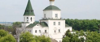
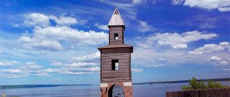
The core of the city was formed by the Kremlin, the site for which was chosen in 1597 on a rocky cliff. The rugged terrain of the left bank determined the division of the city into four parts, preserved in the general plan of the 1780s. Along the bend of the river and the Siberian Highway there is the Yamskaya Sloboda (1600), on the cape between the Kalachik and Sviyaga rivers there is the St. Nicholas Monastery (1604), then the Kremlin (the Kremlin’s battle gates with portals, 1700-13) with the Trinity Church (1598) have been preserved. Behind the fortress wall and the Derneika river is the Intercession Monastery (1621).
The dominant features of the city are the five-domed Trinity Cathedral with a multi-tiered bell tower (1703-04), and the Church of the Resurrection of the Savior (1786). To the south of the cathedral, on the square is the large eight-domed Cathedral of the Exaltation of the Cross of the St. Nicholas Monastery (1905-13) with the northern aisle of St. Simeon of Verkhoturye. On the eastern outskirts of the city, behind the former city rampart, there is the Assumption Church in the cemetery (1815) with a bell tower above the entrance.
Buildings from the 19th century. was almost exclusively wooden. A small number of stone civil buildings are concentrated in the square in front of the Trinity Cathedral (now a public garden): the voivode's house and the voivode's office, the official hut, state barns (all from the beginning of the 18th century, partially preserved), and a prison. The most notable are the hospital, the Yushkov house (late 18th - first half of the 19th centuries), the wooden “House for Receiving Noble Guests” (1916, now a museum), built by order of G.E. Rasputin near the western wall of the St. Nicholas Monastery.
60 km east of Verkhoturye, down the river. Tura, in the village of Merkushino (the trading, shipbuilding and religious center of the region in the 18th - early 20th centuries), - the Church of St. Simeon Verkhotursky (1887, dilapidated). The church was built on the site of a chapel above the original burial place of the saint. Part of the former large church and park ensemble has been preserved.
| Population by year (thousands of inhabitants) | |||||||
| 1856 | 3.0 | 1996 | 8.7 | 2008 | 7.4 | 2017 | 8.7 |
| 1897 | 3.2 | 1998 | 8.5 | 2010 | 7.4 | 2018 | 8.6 |
| 1939 | 7.2 | 2000 | 8.4 | 2011 | 8.8 | 2019 | 8.6 |
| 1959 | 10.9 | 2001 | 8.3 | 2012 | 8.8 | 2020 | 8.6 |
| 1970 | 9.7 | 2003 | 7.8 | 2013 | 8.8 | 2021 | 8.5 |
| 1979 | 9.0 | 2005 | 7.6 | 2014 | 8.8 | ||
| 1989 | 9.0 | 2006 | 7.5 | 2015 | 8.7 | ||
| 1992 | 9 | 2007 | 7.4 | 2016 | 8.7 | ||
Links[edit]
- "26. The size of the permanent population of the Russian Federation by municipalities as of January 1, 2021". Federal State Statistics Service. Retrieved January 23, 2021.
- "On the Calculation of Time". Official Internet portal of legal information
. June 3, 2011. Retrieved January 19, 2021. - Post office. Information and computing center of OASU RPO. ( Post office
).
Search for postal service objects ( postal Search for objects
) (in Russian) - Russian Federal State Statistics Service (2011). “All-Russian Population Census 2010. Volume 1" [All-Russian Population Census 2010, vol. 1]. All-Russian Population Census 2010 [All-Russian Population Census 2010]
. Federal State Statistics Service. - ↑
Federal State Statistics Service of Russia (May 21, 2004).
“The population of Russia, the constituent entities of the Russian Federation as part of federal districts, urban settlements, settlements, settlements is 3 thousand or more people” [Population of Russia, its federal districts, federal districts, districts Urban settlements, rural settlements - administrative centers and rural settlements with a population of over 3,000] (XLS). All-Russian Population Census 2002
. - “All-Union Population Census of 1989. The current population of union and autonomous republics, autonomous regions and districts, territories, negative phenomena, urban settlements and rural district centers” [All-Union Population Census of 1989: current population of union and autonomous republics, Autonomous regions and districts , territories, regions, districts, towns and villages performing the functions of district administrative centers. All-Union Population Census of 1989 [All-Union Population Census of 1989]
.
Institute of Demography of the National Research University: Higher School of Economics [Institute of Demography of the National Research University: Higher School of Economics]. 1989 - via Demoscope Weekly
.
Population[ | ]
| Population | |||||||||
| 1856[7] | 1897[7] | 1959[8] | 1970[9] | 1979[10] | 1989[11] | 1992[7] | 1996[7] | 1998[7] | 2000[7] |
| 3000 | ↗3200 | ↗10 917 | ↘9688 | ↘8966 | ↗8973 | ↗9000 | ↘8700 | ↘8500 | ↘8400 |
| 2001[7] | 2002[12] | 2003[7] | 2005[7] | 2006[7] | 2007[7] | 2008[13] | 2009[14] | 2010[15] | 2011[7] |
| ↘8300 | ↘7815 | ↘7800 | ↘7600 | ↘7500 | ↘7400 | →7400 | ↘7398 | ↗8820 | ↘8800 |
| 2012[16] | 2013[17] | 2014[18] | 2015[19] | 2016[20] | 2017[21] | 2018[22] | 2019[23] | 2020[24] | 2021[2] |
| ↗8809 | ↘8776 | ↘8771 | ↘8748 | ↘8678 | ↘8651 | ↘8612 | ↘8593 | ↘8563 | ↘8525 |
As of January 1, 2021, in terms of population, the city was in 974th place out of 1116[25]cities of the Russian Federation[26].
Architecture
Before the revolution in Verkhoturye, along with chapels, there were more than 20 churches.
Currently, there are eight churches in Verkhoturye.
- Cathedral of the Exaltation of the Holy Cross (a stone, three-altar church was founded on September 12, 1905. From the moment of its foundation, by decree of the Synod it was given cathedral status. Built in the Russian-Byzantine style (architect A. B. Turchevich). The main temple in honor of the Exaltation of the Holy Cross was consecrated on September 11, 1913. On its consecration was awaited by the arrival of Nicholas II. The left chapel in the name of the righteous Simeon of Verkhoturye was consecrated on May 27, 1914. The right chapel in honor of the Dormition of the Blessed Virgin Mary was consecrated on September 10, 1916. After the closure of the monastery in 1925, it received parish status. In 1929, the relics of the righteous Simeon of Verkhoturye were removed from the cathedral. closed in 1929. Returned in 1990. The main temple was re-consecrated on August 19, 1999 and has the status of a monastery),
- Transfiguration Church and Simeon-Anninskaya Gate Church.
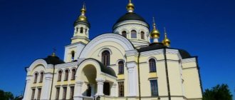
- Holy Trinity Cathedral of the Verkhoturye Kremlin (the first stone temple of the Trans-Urals, built on the site of a wooden church in the name of the Life-Giving Trinity. The two-altar, five-domed temple, founded in 1703, received cathedral status from the moment of its foundation by decree of the Synod. Built in the Baroque style. The main temple in honor of the Holy Life-Giving Trinity, consecrated April 16, 1709.),
- Intercession Church of the Holy Intercession Women's Monastery,
- Assumption Cemetery Church.
- Nicholas Church of the Nicholas Monastery, built in 1999 on the site of the church of the same name demolished during Soviet times, and the Resurrection Prison Church at the establishment of USH 349/53.
- Temples of Verkhoturye
- Coat of arms of Verkhoturye
- Holy Cross Cathedral
- Holy Trinity Cathedral of the Verkhoturye Kremlin
Content
- 1. History
- 2 Geography and climate
- 3 Population
- 4 Economics
- 5 Transport
- 6 Attractions 6.1 City cultural institutions
- 6.2 Architectural monuments of the city
- 7.1 Nikolaevsky Monastery
- 9.1 Voivodes
Historical reference
Verkhoturye, a city in the Verkhoturye Municipal District of the Northern UO, was founded in 1598 after Tsar Fyodor Ioannovich signed a charter on October 12, 1597 on the construction of a city on the Tura River. Somewhat earlier, in 1595, a decree was issued to build, instead of the existing Vishersko-Lozvinsky route, a more direct and shorter route from Solikamsk to Siberia through the Ural Mountains, to the upper reaches of the river. Tura, which later received the name Babinovskaya_road [1] after the Solikamsk peasant Artemy Babinov, who paved the new path.
The city received the name Verkhoturye due to the fact that before the beginning of the 18th century. it was the most “upstream” of the river. Tura. For almost 150 years, the city became the main transit point on the main trade route from Russia through Solikamsk to the Siberian fortified cities.
In 1763, the customs house was closed, and even earlier, the Babinovskaya road lost its exceptional position. Already in 1721, permission was given to Kazan, Ufa and Kungur merchants to travel to the Irbit fair not through Verkhoturye, but through the Uktus plant, the southern outskirts of modern Yekaterinburg.
Verkhoturye finally found itself aloof from the main traffic flow after the construction of the new Siberian Highway (1763) through Kungur and Yekaterinburg to Tyumen and the construction of the Gornozavodskaya railway in 1878. from Perm to Yekaterinburg. There are two museums in the city - the Verkhoturye Historical and Architectural Museum-Reserve and the Orthodox Museum in the Nikolaevsky Monastery. Population 7.82 thousand people.
In terms of the number of residents and economic development, Verkhoturye ranks last among the cities of the Sverdlovsk region, but in terms of historical and cultural potential it has no equal. This city is the Orthodox center of the Urals, its spiritual capital.