| Mozdok |
Mozdok
, a city in Russia, the administrative center of the Mozdok district of the Republic of North Ossetia-Alania, the center of the Mozdok deanery of the Vladikavkaz diocese. Located on the southern edge of the Terek-Kumskaya lowland, on the high left bank of the Terek River, 92 km north of Vladikavkaz. Railway station and highway junction. Population - 41.7 thousand people. (2018).
- On the map: Yandex.Map, Google map
The settlement in the Mazdogu
(from Kabardian
mez
, “forest” and
degu
, “deaf”) was founded in 1759.
In 1763, the owner of Lesser Kabarda, Kurgoko-Kanchokin, who accepted Russian citizenship and Orthodoxy, built a fortified outpost here in the center of the Caucasian border lines, a church was built, and a customs office was established. In the same year, the city of Mozdok
was established by decree of Empress Catherine II and became one of the six regular fortresses of the Caucasian line. The military-strategic importance of the city in the fortified line system was very great. Military equipment, weapons and provisions were delivered from Astrakhan through Mozdok; Until 1825, the Georgian Military Road passed through the city, connecting Russia with Transcaucasia. The first school and the first printing house in the North Caucasus were opened here.
In 1785, Mozdok received the status of a district town of the Caucasian region of the Caucasian governorship. In 1796-1803 it was part of the Astrakhan province, and from 1803 - part of the Caucasus (later Stavropol) province. The economic importance of Mozdok was determined primarily by its favorable geographical location. Located at the crossroads of the most important trade roads, Mozdok daily received and sent numerous merchant caravans from Central Russia to mountain villages, Cossack villages and to distant Transcaucasia. At the end of the 18th - first half of the 19th centuries, it was a major trading center in the North Caucasus and was famous for the Mozdok autumn fairs. In 1823, Russian peasants, the Dubinin brothers, built one of the first oil refineries in Russia in Mozdok, where kerosene production began.
During the Caucasian War in 1840, the city was attacked by detachments of mountaineers led by Imam Shamil.
Since 1860, it was part of the Terek region, and until 1863 it was its administrative center. In the 1870s, after the construction of a railway connecting Rostov-on-Don with the western coast of the Caspian Sea, Mozdok remained away from the highway and lost its economic importance. In 1897 it was a provincial town in the Pyatigorsk district, and at the turn of the 19th century it was a settlement. Mozdok remained a trading center for nearby Cossack villages and Ossetian settlements.
During the Civil War, Mozdok was the scene of military operations. In 1923, Mozdok was re-established as a city [1].
During the Great Patriotic War, fierce battles took place in the area of the city of Mozdok. On August 25, 1942, the city was occupied by Nazi troops. Liberated on January 3, 1943 by troops of the Transcaucasian Front during the North Caucasus Operation.
In 1944, Mozdok was transferred from the Stavropol Territory to the North Ossetian Autonomous Soviet Socialist Republic, and the city itself was elected the administrative center of the newly formed Mozdok region. By the end of the Soviet period, a curtain factory, mechanical repair and brick factories operated in the city; The food industry was developed (brewery, winery, dairies, meat processing plants) [2].
The military significance of the city again manifested itself at the turn of the 21st century, during the active phase of the anti-terrorist operation in the North Caucasus, when the city played a prominent role as one of the most significant strategic strongholds in the south of Russia.
Statistics
- 1856 - 10 thousand people, 6 churches, 1207 houses, 131 shops
- 1897 - 9.3 thousand people
- 1913 - 20.2 thousand people
- 1939 - 19.1 thousand people
- 1959 - 25.6 thousand people
- 1970 - 32.4 thousand people
- 1989 - 38 thousand people
- 2003 - 42.9 thousand people
Geography
The city is located on the left bank of the Terek River, in the central part of the Mozdok region. It is located 95 km (by road) and 84 km (as a straight line) north of the city of Vladikavkaz.
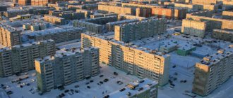
The area of the urban settlement is 17.50 km2. From west to east the city has a length of about 6 km, from south to north about 6.5 km.
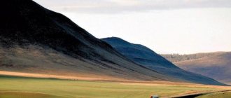
The city is located in the flat forest-steppe zone of the republic. The terrain is relatively flat. Height fluctuations are insignificant. In the southern part of the city stretches a chain of hilly hills. The average altitude in the city is about 130 meters above sea level.
The coastal zone of the Terek River is occupied by riverine forests protected by the State Forest Fund. To the south of the city in the valley of the Terek River there is Victory Park [hy] (Ossetian Uælahizy Park). To the southeast of the city stretches the largest forest in the region - the Alborovsky Forest.
The hydrographic network is represented mainly by the Terek River. To the south of the city in the valley of the Terek River there are dammed lakes. To the north of the city there are canals - Tersko-Kumsky and its branch Burunny. To the north-west of the city there is Lake Kara.
Sights of the city of Mozdok (North Ossetia - Alania)
North Ossetia-Alania is a republic within the Russian Federation, located on the northern slope of the Greater Caucasus.
A satellite map of North Ossetia-Alania shows that the region borders Ingushetia, Georgia, Chechnya, Kabardino-Balkaria, Stavropol Territory and partially recognized South Ossetia. Territory area - 7987 sq. m. The territory of the republic is divided into 8 districts and 1 city of republican subordination. The largest cities of North Ossetia are Vladikavkaz (the capital), Mozdok, Beslan, Alagir and Ardon. The region's economy is based on alcohol production (23 enterprises), non-ferrous metallurgy, mechanical engineering and mining.
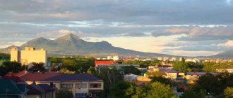
Mount Kazbek in North Ossetia-Alania
Notes
- ↑ 12
The permanent population of the Russian Federation by municipalities as of January 1, 2021 (Russian). Date accessed: April 27, 2021. Archived May 2, 2021. - Pospelov, 2008, p. 294.
- Vasily Potto - Caucasian War. Volume 1. From ancient times to Ermolov.
- According to the petition of the Mozdok city society dated December 21, 1867, submitted to the head of the Terek region M. T. Loris-Melikov, and a certificate from the Terek regional drawing office for 1912.
- Chronicle of administrative and territorial changes affecting the Stavropol region from 1785 to the present (unspecified)
(inaccessible link). Retrieved June 1, 2013. Archived July 18, 2021. - On the inclusion of the city of Mozdok, Stavropol Territory, into the North Ossetian Autonomous Soviet Socialist Republic (Russian) (inaccessible link). Mozdoksky “Styr nykhas”. Access date: October 31, 2015. Archived March 3, 2014.
- Service on the edge of the Caucasus (undefined)
. Red Star (September 27, 2005). Date accessed: February 22, 2021. Archived March 10, 2021. - ↑ 1 2 3 4 5
Population of North Ossetia
(undefined)
. Retrieved April 10, 2021. Archived April 10, 2016. - Administrative-territorial structure of Stavropol from the end of the 18th century to 1920: [arch. December 22, 2017] / Committee of the Stavropol Territory for Archival Affairs, State Archive of the Stavropol Territory; comp. G. A. Nikitenko (responsible author), E. B. Gromova, M. I. Krivneva. - Stavropol: JSC Publishing and Printing, 2008. - 399 p.
- ↑ 1 2 3 4 5 6 7 8 9 10 11 12 13 14
People's Encyclopedia “My City”.
Mozdok (undefined)
. Retrieved June 21, 2014. Archived June 21, 2014. - All-Union Population Census of 1939. The size of the urban population of the USSR by urban settlements and intra-city areas (unspecified)
. Retrieved November 30, 2013. Archived November 30, 2013. - All-Union Population Census of 1959. The size of the urban population of the RSFSR, its territorial units, urban settlements and urban areas by gender (Russian). Demoscope Weekly. Access date: September 25, 2013. Archived April 28, 2013.
- All-Union Population Census of 1970 The size of the urban population of the RSFSR, its territorial units, urban settlements and urban areas by gender. (Russian). Demoscope Weekly. Access date: September 25, 2013. Archived April 28, 2013.
- All-Union Population Census of 1979 The size of the urban population of the RSFSR, its territorial units, urban settlements and urban areas by gender. (Russian). Demoscope Weekly. Access date: September 25, 2013. Archived April 28, 2013.
- All-Union population census of 1989. Urban population (undefined)
. Archived from the original on August 22, 2011. - All-Russian population census 2002. Volume. 1, table 4. Population of Russia, federal districts, constituent entities of the Russian Federation, districts, urban settlements, rural settlements - regional centers and rural settlements with a population of 3 thousand or more (unspecified)
. Archived from the original on February 3, 2012. - The size of the permanent population of the Russian Federation by cities, urban settlements and regions as of January 1, 2009 (unspecified)
. Retrieved January 2, 2014. Archived January 2, 2014. - Volume 1. Number and distribution of population. Table 10
- ↑ 1 2 3 4
Estimation of the population of municipalities of the Republic of North Ossetia-Alania as of January 1, 2011-2015
(unspecified)
. Retrieved May 4, 2015. Archived May 4, 2015. - Population of the Russian Federation by municipalities as of January 1, 2015 (unspecified)
. Access date: August 6, 2015. Archived August 6, 2015. - Population of the Russian Federation by municipalities as of January 1, 2021 (Russian) (October 5, 2018). Date accessed: May 15, 2021. Archived May 8, 2021.
- Population of the Russian Federation by municipalities as of January 1, 2021 (Russian) (July 31, 2017). Retrieved July 31, 2021. Archived July 31, 2021.
- Population of the Russian Federation by municipalities as of January 1, 2021 (Russian). Retrieved July 25, 2018. Archived July 26, 2021.
- Population of the Russian Federation by municipalities as of January 1, 2021 (Russian). Date accessed: July 31, 2019. Archived May 2, 2021.
- Population of the Russian Federation by municipalities as of January 1, 2021 (Russian). Date accessed: October 17, 2021. Archived October 17, 2021.
- taking into account the cities of Crimea
- https://rosstat.gov.ru/storage/mediabank/bul_Chislen_nasel_MO-01-01-2021.rar Population of the Russian Federation by municipalities as of January 1, 2021 (1.85 Mb, 07/30/2021)
- Volume 4. Table 4. National composition of the RSOA by municipalities according to the 2010 census (unspecified)
(inaccessible link). Date accessed: October 19, 2021. Archived August 19, 2013. - Volume 2. Age, sex composition and marital status (unspecified)
(inaccessible link). Date accessed: February 25, 2021. Archived March 4, 2021. - [1] “World Map of Köppen−Geiger Climate Classification”
- Kaloev B. A. Mozdok Ossetians (Historical and ethnographic research). - M.: Nauka, 1995. - 245 p.
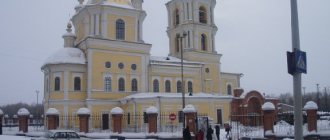
- Assumption-Nikolskaya Church (undefined)
.
Website of the Dormition of the Mother of God in the city of Mozdok
(September 6, 2019). - Chapel at the district hospital in honor of the holy great martyr and healer Panteleimon, Mozdok inaccessible
link -
history
). - Chapel in honor of the Kazan Icon of the Mother of God, Mozdok (unspecified)
(inaccessible link). Access date: December 25, 2012. Archived May 31, 2014. - North Ossetia celebrates the 70th anniversary of the Battle of the Caucasus
Population
Main article: Population of Mozdok
| Population | ||||||||||
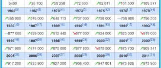
| 1803[8] | 1825[9] | 1850[8] | 1856[10] | 1897[10] | 1913[10] | 1915[8] | 1923[8] | 1926 | 1931[10] | 1939[11] |
| 4097 | ↗4209 | ↗6680 | ↗10 000 | ↘9300 | ↗20 200 | ↘11 955 | ↘10 840 | ↗14 000 | ↗15 500 | ↗19 081 |
| 1959[12] | 1967[10] | 1970[13] | 1976[8] | 1979[14] | 1989[15] | 1992[10] | 1996[10] | 1998[10] | 2000[10] | 2002[16] |
| ↗25 611 | ↗31 000 | ↗32 350 | ↗34 300 | ↗34 394 | ↗38 037 | ↗39 300 | ↘39 100 | ↗39 200 | ↗39 300 | ↗42 865 |
| 2003[10] | 2005[10] | 2006[10] | 2007[10] | 2008[10] | 2009[17] | 2010[18] | 2011[19] | 2012[19] | 2013[19] | 2014[19] |
| ↗42 900 | ↘41 800 | ↘41 300 | ↘40 800 | ↘40 500 | ↘40 383 | ↘38 768 | ↘38 698 | ↗39 089 | ↗39 232 | ↗39 432 |
| 2015[20] | 2016[21] | 2017[22] | 2018[23] | 2019[24] | 2020[25] | 2021[1] | ||||
| ↗40 042 | ↗40 564 | ↗41 409 | ↗41 728 | ↗42 155 | ↘42 039 | ↘41 459 | ||||
As of January 1, 2021, in terms of population, the city was in 368th place out of 1116[26]cities of the Russian Federation[27].
Density - 2369.09 people/km2.
National composition
According to the 2010 All-Russian Population Census[28].
| People | Number of people, people | Share of the total population, % |
| Russians | 22 918 | 59,12 % |
| Ossetians | 3 209 | 8,28 % |
| Kumyks | 2 741 | 7,07 % |
| Armenians | 2 399 | 6,19 % |
| Chechens | 1 359 | 3,51 % |
| Kabardians (Circassians) | 1 280 | 3,30 % |
| Turks | 789 | 2,03 % |
| Koreans | 764 | 1,97 % |
| Ukrainians | 590 | 1,52 % |
| other | 2 148 | 5,54 % |
| nationality not specified | 571 | 1,47 % |
| Total | 38 768 | 100,0 % |
Sex and age composition
According to the 2010 All-Russian Population Census[29]:
| Age | Men, persons | Women, persons | Total number, people | Share of the total population, % |
| 0 – 14 years | 3 654 | 3 284 | 6 938 | 17,90 % |
| 15 – 59 years | 12 104 | 12 535 | 24 639 | 63,55 % |
| from 60 years old | 2 427 | 4 764 | 7 191 | 18,55 % |
| Total | 18 185 | 20 583 | 38 768 | 100,0 % |
Men - 18,185 people. (46.9%). Women - 20,583 people. (53.1%).
The average age of the population is 37.9 years. The median age of the population is 36.3 years.
The average age of men is 33.9 years. The median age of men is 30.8 years.
The average age of women is 41.4 years. The median age of women is 41.5 years.
Brief history of North Ossetia-Alania
Since the 9th century, the Alan state was located on the territory of modern North Ossetia. In 1774 the region was annexed to the Russian Empire. In 1924 it was transformed into an autonomous region, and in 1936 - the North Ossetian Autonomous Soviet Socialist Republic.
In 1992, armed conflicts took place on the territory of North Ossetia. Due to its proximity to Chechnya, the republic was often subject to terrorist attacks. On September 1, 2004, a terrorist attack occurred with the seizure of a school in Beslan.
Necropolis near the village of Dargavs
Economy
- Food industry enterprises: winery, meat processing plant, bakery
- Pulp and paper industry: cardboard mill
- Meat processing plant "Bogachev's Meat Dvor"
- Railroad station
- Curtain factory - Mozdok Patterns (JSC)
- Bakery
- Biological products plant
- Garment factory
In the region, the main role in agriculture is played by grain growing, viticulture, melon growing, and beekeeping. Currently, the economy is in complete stagnation or degradation.
Monuments
| The section lacks links to sources. Information must be verifiable or it may be deleted. You can edit the article to add links to authoritative sources. This mark was set on April 27, 2021 . |
Kunaki Restaurant-Museum in Mozdok
- Monument to the 337th Infantry Division[35],
- Monument to the Dubinin brothers,
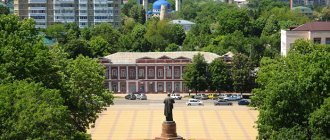
- Lenin monument,
- Monument to Pilots Heroes of the Second World War,
- Monument to Sergei Kirov,
- Monument to Saint George the Victorious,
- Monument to Alexander Pushkin,
- Monument to a thinking citizen,
- Monument to Emelyan Pugachev,
- Monument to the Defenders of Mozdok,
- Monument to Kosta Khetagurov,
- Monument to General Secretary Andropov.
Education
- 12 high schools,
- 20 kindergartens
- palace of culture,
- Children's music school named after. Glinka,
- art school,
- Mozdok branch of the Moscow Academy of Economics and Law,
- Mozdok branch of Vladikavkaz Mountain State Agrarian University,
- Mozdok Museum of Local History
- Mozdok children's art school,
- Children's and youth sports school,
- Mozdok centralized library system, which includes 4 city and 21 rural libraries.
- GPTU,
- Mozdok Mechanical and Technological College