In Russia there are as many as 2 Troitsk. One is located in the Moscow urban district, and the other is in the Chelyabinsk region. The first one is better known, and we will talk about it in a little more detail.
Troitsk (Moscow) is a city located in the Troitsky administrative district of Moscow. It is located in the southwest of the Russian capital, 20 km from the Moscow Ring Road, if you follow the Kaluga highway. Until July 1, 2012, it was part of the Moscow region. Since 2007, it has the status of a science city. The area of the city is 16.3 km². The population of Troitsk, Moscow region, is 60,924 people.
The climate in the city is temperate continental. The average temperature in January is -10.8 °C, and in July - +17.2 °C.
Economics and transport
Troitsk is a modern settlement with developed infrastructure. Multi-storey residential buildings predominate here. The city is very green and surrounded by forests. There are no harmful enterprises. Combined with intensive housing construction, this leads to population growth. Schools, a lyceum, 2 gymnasiums, kindergartens, medical institutions, a sports school, and shops were built here; The sphere of consumer services is developed.
But the transport situation is still quite unfavorable. This is due to congestion on the Kaluga Highway, which connects Troitsk with Moscow. Construction of the metro line was supposed to begin in 2021.
SQUARE OF THE CITY OF TROITSKAALEXANDROVSKAYA , post-revolutionary name Red. A place free from various buildings in the area of the church in the name of Alexander Nevsky on the outskirts of Amur was the temple square and the beginning of the main street of the village of Amur - Bolshaya Alexandrovskaya (now named after P. Krakhmalev). Currently, school No. 15, a bus station, and a residential sector are located here.
BAZARNAYA (Upper) . It was the end of two central city streets - Orenburgskaya (Oktyabrskaya) and Bazarnaya (named after Lenin). On the western side it was almost closely adjacent to a kind of “industrial zone” - to numerous semi-handicraft factories densely located along the right bank of the Uvelka River; tanneries, sheepskin-fur coats, butter churns, wool washers... Now on the site of this square there is school No. 14, a motor transport enterprise, a bath and laundry plant, etc.
BAZARNAYA (Lower). The largest area both in terms of length and occupied territory. The northern border of the square extended along the bank of the Uvelka River: from the end of Vasilyevsky Lane (A. Klimov Street), from the wood row and timber warehouse of Tyrin, blacksmith rows to Sennaya (see Komsomolskaya) square. On the southern side it was enclosed by the passage of the Yaushev brothers, the trading houses of Valeev and Bakirov, and the warehouses and warehouses of the grain merchant Chetyrkin. In the free space of the square there is now a park named after. Pavlik Morozov, residential buildings and the city market.
CITY (no longer exists). This square was once located on the site where the city park of culture and recreation is now located. N. D. Tomina. Before the foundation of the city garden, it served as a place for citywide celebrations.
DMITRIEVSKAYA (Tabunnaya) . The square originated from the walls of the church in the name of Dmitry of Thessalonica, the fences of the Orthodox cemetery and the Kazan nunnery. On its territory there are residential buildings of the so-called. 16th quarter. And it began to be called Tabunnaya in the late 30s, since private herds gathered here: the Forshtadt one, the city one and two Novonarezovsky ones.
KOMSOMOLSKAYA Square is the central part of the former Sennaya Square, which was intermediate between the Upper and Lower Bazar Squares. It also extended along the Uvelka River, on the banks of which there were a line of washing, laundries and “eating” establishments of the so-called. Bath row. Now on the territory of this square there are residential buildings of block “A”, school No. 3, and retail outlets.
The square began to be called Komsomolskaya on the eve of the 50th anniversary of the Trinity Komsomol.
MAY (formerly called Cossack) . After the loss of Mikhailovskaya (see Central) Square its original significance, the garrison parade ground and parade square became a vacant lot adjacent to the “connected Pupyshevskaya hospital-almshouse” and being the basis of Bazarnaya Street (named after Lenin).
This square received its new name in honor of the first legal demonstration and mass meeting of Trinity residents in May 1917 and in memory of the events held in 1905-1906. country May Days.
Station Square. Its formation began in the summer of 1911, i.e., from the time of completion of construction work on the delivery of the railway station and other service buildings in preparation for the launch of the Poletayevo-Troitsk railway line.
PROLETARSKAYA (formerly called Kuznetsovskaya) . It was located in Kuznetsovskaya Sloboda, next to the steam mill of the mayor of Kuznetsov. After the revolution, Kuznetsovskaya Sloboda began to be called Proletarskaya, and accordingly it changed its name and area. In past times, there was a Muslim mosque here; now school building No. 7 is noteworthy.
Among the former and currently existing city squares, the very first in seniority and importance was the CATHEDRAL Square. It was practically the same age as the city, as it arose with the foundation of the very first Orthodox church of the New Trinity Fortress - the Holy Trinity Cathedral (Uysky or Old).
The Cathedral Square stretched on both sides of the cathedral along the left bank of the border river Uy. In subsequent years, a park with alleys was laid out on it. In the post-war years, the area as such was liquidated and a five-story dormitory for the veterinary (agricultural) technical school was built here.
CENTRAL (formerly called Mikhailovskaya, named after Razin, Sovetskaya) . Before the construction of the cathedral in the name of the Archangel and Archangel Michael began, the square was not only dominant, but also served as a garrison parade ground. The construction and commissioning of both the cathedral itself and the Asian shopping mall rows, the closed square of streets and alleys limited its space, and then, with the foundation of the public garden, it became completely insignificant in its territory. The location of this square was designed in those years when the future Troitsk compactly fit into the square of Naberezhnaya, Bazarnaya, Bakakinsky and Vasilyevsky lanes (now Krasnogvardeyskaya, Lenin, Pionerskaya, Klimov streets).
For decades, the future main square of the city remained a wasteland. On the “Plan of the surrounding area of the city of Troitsk (1835)”, the area remained in its original form and nameless. This continued until construction of a new Orthodox church began on the vacant site.
The laying of the new temple was initially planned to take place on Michaelmas Day (November 8, old style), when the bread was harvested and the passions of the fair and trade died down.
The spiritual and secular authorities were forced to reconsider their previously planned plans by the news that Grand Duke Vladimir would visit Troitsk in early June 1868. But even after the prince’s arrival, they decided to leave the name of the temple as it was planned before - in the name of Archangel Michael.
St. Michael's Cathedral was greeted not only by such a celebrity as Prince Vladimir, in 1890 Tsarevich Nicholas (later emperor) came to Troitsk. After the solemn parade, he went to St. Michael's Church. There was such a crowd of people that the officers of the battery and the privileged regiment had to hold back the crush. After serving a short prayer service, the Sovereign Heir proceeded on foot to his apartment located near the church. From morning until late at night, a joyful “hurray” buzzed throughout the city. The city government building was decorated artistically, and the small garden near St. Michael's Church was brightly lit, with a bust of Emperor Alexander, father of Nicholas and Vladimir, standing out in relief.
The idea of building a new temple was dictated by the fact that the old Uysky Cathedral had become cramped for the increasing number of townspeople. Ancestors from all over the world raised funds for the construction of the temple, unknown craftsmen erected this man-made miracle of architecture, and merchants spared no expense on the construction. But could they have imagined that just a few decades later other “city fathers” would not spare people’s money to blow up this temple and perpetuate the savage memory of themselves. This barbarity occurred in 1967. Mikhailovskaya Square differed from other Troitsk squares in that it was surrounded by respectable administrative buildings and residential mansions. The city government building (now the post office building) looked out onto the square with all its windows; it was decorated with the buildings of the Siberian Trade Bank ( museum) and the district Cossack court (administration). The square was closed on the south side by Gostiny Dvor (Trading Rows). On June 22, 1941, Trinity residents gathered on Central Square when they received news of an attack on the Soviet Union by fascist invaders.
There are now events and parades taking place in the town square
ENERGETIKOV Square - in front of the building of the Energetik Palace of Culture (GRES village)
Microdistricts of the city
Amur - In 1813-1814, in the floodplain of the Uvelka River, which lay on the left bank opposite from the Upper Bazarnaya and Sennaya squares, with the mutual consent of the city authorities and the leadership of the 3rd department of the OKW, residential plots began to be cut for housing construction. The land was allocated first of all to the brave Bashkir Cossacks who returned “from the battlefield” and distinguished themselves as accurate archers. It is no coincidence that the French nicknamed them “Northern Cupids” for the accuracy of their arrows. In honor of the first settlers of this suburb - the “Cupids”, who decided to settle in Troitsk for permanent residence, it was named Amur. With the construction of a Muslim mosque in this suburb, Tatars began to settle here: artisans, owners of visiting yards and inns for trade guests (merchants) from Central Asian khanates and emirates. At the beginning of the 20th century, an Orthodox church in the name of St. Alexander Nevsky was erected and consecrated here. Goncharka - As a suburb, Goncharka began to form after the survey work of the builders of the future Poletayevo-Troitsk railway line. It was they who were the first to discover large deposits of excellent clay, suitable for the production of bricks and pottery. Therefore, almost from the beginning of the construction of the future railway station and station service buildings, clay mining began. After delivery in 1911 During the operation of the branch line and the arrival of the first steam locomotive behind the “cast iron road”, the first residential houses of master potters began to appear in the steppe, who established the production of pots, jars, pots, cups and other earthenware. The demand for these products was so great that the so-called. pot row. The suburb (village) began to bear the name Goncharka. GRES - In 1954, on the site of steppe glades and birch small forests, where surveyors’ tents had stood quite recently, the first teams of arriving builders began work on the construction of the Troitskaya GRES. But before erecting the buildings of the power plant, the first builders took up housing and change rooms. The village grew literally before our eyes, its streets appeared one after another. Only the name of the village remained unchanged - GRES, a government abbreviation name. At one time, on the pages of the newspaper “Forward” there was a discussion about the need to change the name of the village, Troitsk residents proposed many dozens of different names, but all the conversations and proposals remained empty words, which is a pity. Zolotaya Sopka - The station village arose in connection with the construction of a junction railway station and the laying of branches to Kustanai and Orsk. The name of the village and Zolotaya Sopka station came from the light hand of the builders. And they called it that not because there was a gold deposit here, but because in the mouth of the Chernushka River, through which the caravan trade road (a branch of the Great Silk Road) lay, “dashing people” - robbers - robbed merchants returning from the Trinity Fair, and took only gold and precious stones. They flew into the caravan quickly, acted quickly and just as quickly rode off on horses into the steppe distance. It is known that many noble Troitsk merchants made their fortune and accumulated initial capital on this big road, in this so-called. "golden place" Kirsarai - Former name Brick Settlement. Just like Kuznetsovskaya Sloboda, it was adjacent to the Amur suburb. The emergence of this village is due to the fact that at the beginning of the century, when the construction of numerous semi-handicraft and large industrial enterprises (steam mills, leather factories, etc.) began in Troitsk, the demand for building bricks increased unprecedentedly. It was then that an empty place was chosen - the left elevated bank of the Uvelka River, the slope of which - sunny, blown by all the winds - turned out to be a godsend for the natural drying of raw bricks. Temporary sheds and sheds for future prominent entrepreneurs, owners of the Zinoviev and Atyushev Kirzavods, were built here. Mirny - In the old days, this village could have been called a “vyselko”, i.e. a settlement that spun off from the settlement of power engineers - State District Power Plant. It arose unplanned, using the “self-construction” method, mainly due to building materials from a power plant being built nearby. The fact of its emergence forced the city authorities, on the eve of the impending elections to the Soviets in the early 60s, to give the newly born village the name Mirny. Meat-processing plant village - The first residential buildings in this village were built at the beginning of the century and served as housing for a small part of the slaughterhouse workers, owned by meat traders Abdrakhman Bayazi-tov and Nikolai Neruchev. And when in 1914, in this region beyond the river, the construction of a meat processing plant began urgently (since the active army demanded canned meat products) by the forces of Austro-German prisoners, and housing construction also intensified. As a microdistrict of compact residence, the village was finally formed in the post-war years. Novaya Narezka - It is characteristic that this village, unlike others, knows the name of its founder. He was Jacob Ernst Leonhard Zukker, who at the beginning of the century, outside the city limits, on a vacant lot, behind the outermost Monastyrskaya Street, built a brewery. Nearby stood his residential mansion, which laid the foundation for the street, later named Moskovskaya (now named after S. Lovchikov), from which, in fact, the village began. Five-Year Plan - The foundation of the village is associated with the construction of a brick factory during the first Five-Year Plans. The production of the kirzavod went mainly to Magnitostroy. Intensive growth of the village occurred during the construction of a rural construction plant here. Sanatorium - It arose in the last century in the area where the television relay is now located, as a country estate and the borrowing of a noble entrepreneur and grain merchant, Cossack officer and city mayor D.V. Kuznetsov. After the revolution, with the development of the Troitsky climate-kumys-therapeutic area, a beautifully landscaped park with alleys and fountains, an artificial pond was transferred to the sanatorium. It was called differently: at first - “Sanatorium of Teachers”, then - “Golden Hill”. The streets of the village formed the Sanatorium Village. Slobodka - Original name - Kuznetsovskaya Sloboda. And it was called that because it was located next to the steam mill of D.V. Kuznetsov, the mayor. After the establishment of Soviet power, the village received a new name - Proletarskaya Sloboda. Over time, the word “Proletarskaya” was forgotten and for many years the village was simply called Slobodka. Station - At different times it was called Privokzalny, Zheleznodorozhny. The village was born simultaneously with the development of railway station services (station, water pumping station, etc.) in 1911. For many years, the newly emerging streets of the village were numbered from 1 to 13. Tokarevka - Before the revolution, on the site of this village there was a settlement of the Cossack esaul Tokarev and next to it there was a slaughterhouse of the meat merchant Yamanchalov. In past years, when a trend towards renaming arose, more than once or twice the question arose of giving the village a new, revolutionary name. Decisions were made on this matter, but the old name of the Trinity remained unchanged. South - In the distant heyday of the Trinity Fair, several koshes (prefabricated camp dwellings of the Kazakhs) huddled near the Exchange Yard, in which lived the families of trade caravan guides and herders. Standing out among them were the capacious white felt boots of the wealthy cattle breeder and prasol Burumbai. That is why in colloquial use today the village of Yuzhny is sometimes called Burumbaika. By the way, pre-revolutionary postcards depicted these cats and the process of milking kumiss mares.
Upper and Lower Forstadts merged in the concept of the townspeople into a single whole - the central part of the city. But few people know about the very first microdistrict, or more precisely, the foundation of the city - the citadel, that is, the true central part of the fortress. And in general, even when the fortress became a city, its center was strictly limited to the square of the current streets: Pionerskaya, them. A. Klimov, Krasnogvardeiskaya and them. V. Lenin. By the way, in the village of Stepnoye (the same age as our city) two of its components still officially exist - Fortress and Forstadt.
Population of Troitsk (Moscow)
There is little data on the population of this city. Obviously, this is due to its small number. After all, the number of residents of Troitsk is very small. In 2021, only 60,924 people lived in this science city. However, the population is increasing rapidly. This has been especially pronounced in recent years. Thus, in 2009, the number of city residents was only 36,762 people. In the 90s and zero years, the population grew at the slowest rate.
The population density of the city of Troitsk is 2900 people/km².
Troitskoe Estate Park
Photo: Maria Vashchuk
Photo: Maria Vashchuk
Photo: Maria Vashchuk
Photo: Maria Vashchuk
Photo: Maria Vashchuk
It is also called Fabrichny - in honor of the nearby Trinity Worsted Factory (
Employment
The employment situation in Troitsk can be characterized in one phrase: high wages, but little work. As of the end of September 2021, the Employment Center offers only 3 vacancies (not counting the standard vacancies for all cities of the Russian Federation for work on a rotational basis). The city needs 2 department heads and a driver. The salary of a department head is from 38 thousand rubles, and that of a driver is from 60 to 63 thousand rubles. The work schedule in all three cases is variable. Probably the majority of Troitsk residents get jobs in Moscow, which can be reached along the Kaluga Highway.
Recreation area "Zarechye"
Photo: Maria Vashchuk
Photo: Maria Vashchuk
Photo: Maria Vashchuk
Photo: Maria Vashchuk
Photo: Maria Vashchuk
Photo: Maria Vashchuk
In the northern part of Troitsk, in the bend of the Desna River, there is a spectacular and lively recreation area “Zarechye”. They improved it in 2014: they laid out pedestrian paths and bicycle paths, installed benches, gazebos and exercise grounds, and built bridges (one of them is even called “Crimean” - it’s so similar to the one in Moscow). The boat station is especially popular: in the warm season, walks along the Desna River are especially romantic. Children, finding themselves in “Zarechye”, rush headlong to the mini-zoo with geese and rabbits, and noisy groups - to barbecue (
Troitsk, Chelyabinsk region
Troitsk, Chelyabinsk region, is located 121 km south of Chelyabinsk. The city appeared on the map in 1784. The area of the territory is 139 km². Population: 75,231 people. Population density – 540.65 people/km². Height above sea level – 170 meters.
The climate here is continental and cold. The average temperature in January is -14.2 °C, and in July - +20.1 °C. Previously, by the way, it was noticeably colder here, especially in winter. Time in Troitsk is 2 hours ahead of Moscow and corresponds to Yekaterinburg time.
Shopping arcades and a complex of ancient buildings of the local branch of ChelSU
On Klimov Street the buildings of the ancient Trading Rows have been preserved. They were built in the 19th century, and in Soviet times were used as warehouses. Nowadays, part of the building was transferred to the Trinity branch of Chelyabinsk State University (CSU). The shopping arcades have the status of a cultural heritage site of federal significance.
Complex of ancient buildings of the local branch of ChelSU
Nearby, in old buildings, also built in the 19th century, the Trinity Branch of ChelSU is located (Oktyabrskaya St., 79). In the summer, beautiful fountains operate next to them.
Population
The population of Troitsk grew until the end of the 80s of the 20th century, after which it decreased almost all the time, and this process continues to this day. In 2021, the number of residents was 75,231 people, which corresponds to 223rd place among all cities of the Russian Federation. At the peak of the late 80s it was 91 thousand people.
By nationality, Russians predominate among the population - 82.5%, Tatars (7.2%). In third place are Ukrainians (3%). In fourth place are Kazakhs (2%).
Residents of Troitsk are called by the following ethno-horonyms: Troichanin, Troichane, Troichanka.
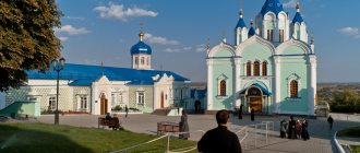
Kazan-Bogoroditsky convent with the Church of the Transfiguration
The Kazan-Bogoroditsky convent was founded in 1851, but was closed during the years of atheism (in the 1920s). One of the monastery churches - Kazan - was dismantled into bricks. The Church of the Transfiguration of the Lord (built in 1870) has been preserved. He is active.
Of the pre-revolutionary buildings of the monastery, the building of the Nikolaev school for girls, built in 1896, as well as the building of the hotel for pilgrims, have also survived to this day.
Kazan-Bogoroditsky convent with the Church of the Transfiguration
The Holy Kazan Convent was revived in the 1990s, through the efforts of Mother Ksenia Kadomtseva. The monastery is open for visits and excursions every day.
Address: st. Gagarina, 1/10.
Employment of the population of Troitsk
As of the end of September 2021, the city requires workers for various specialties. Among them there are many technical ones. Salaries vary: from 12,837 rubles to 42,171 rubles. The smallest is for an accountant, electrician, turner and athlete. Such salaries also occur in the field of pedagogy. The highest is for an engineer.
In general, salaries up to 15-20 thousand rubles dominate the list of vacancies. Salaries above 20,000 are rare.
Water tower
The first iconic landmark of the city, which is found right at the entrance to its central part, is the water tower, built in the style of early postmodernism.
Water tower
It seems that this octagonal structure in the Gothic style was erected somewhere in the Middle Ages. However, it was built in Soviet times - in 1927, according to the design of the architect V. Sanzharevsky. The tower is deservedly recognized as an architectural monument.
Address: st. Gagarin.
Ancient buildings in the Central Square area
Before the revolution, the city's Central Square was called Mikhailovskaya - St. Michael's Cathedral stood on it, demolished in 1967. Now on the Central Square there is a city administration building (Klimova St., 7). In the old days, this building, built in 1873, occupied a fire station.
The complex of historical buildings of the Central Square also includes the Main Post Office building (Lenin St., 69). The post office is located in the former mansion of the merchant Osipov.
Hotel Bashkirova
The most beautiful building in the city of Troitsk is the Bashkirov Hotel (Klimova St., 9). It was built in Art Nouveau style in 1908 by merchant Gavriil Alekseevich Bashkirov, and is intricately decorated with a colonnade, rich stucco moldings and multi-colored stained glass windows. This building, restored in 2011, is an architectural monument of federal significance.
Bashkirov, while at the Nizhny Novgorod fair, made a bet with local merchants who did not believe him that in Troitsk there was a magnificent hotel with a first-class restaurant. Returning home, Bashkirov urgently invested a large sum of money in the construction of a modern hotel.
And when Nizhny Novgorod merchants arrived at the Trinity Fair, they were amazed by the beauty of the brand new hotel, quickly built in the Russian Art Nouveau style.
Across the road, in the former building of the Siberian Bank 1893-1903. buildings, there is the Trinity Museum of Local Lore (Lenin St., 70). Here you can get acquainted with the history of the city in a fascinating way.