Many people prefer to spend their holidays abroad or in the south of Russia. But there are places in the north and east of the country that amaze with amazing views. For example, few people know how beautiful and interesting the cities of Kamchatka are. In the summer, you can spend your vacation without leaving the bounds of your vast Motherland. Kamchatka is a wonderful place for lovers of beautiful views and clean air.
The cities and towns of Kamchatka are unique and amazing. They give you the opportunity to enjoy stunning scenery without leaving your home.
Where is Kamchatka located and the origin of its name
Kamchatka on the map of Russia occupies 2.8% of the territory. A huge peninsula in the northeast of the country, stretching 1200 km almost exactly to the south. Kamchatka and the Kuril Islands, which extend it, separate the Sea of Okhotsk from the Pacific Ocean. The Kamchatka region, with its center in Petropavlovsk-Kamchatsky, was formed in 2007 by the annexation of the Koryak Autonomous Okrug to the Kamchatka region.
The peninsula got its name from the river of the same name. The toponym “Kamchatka” first appears in 1667 on a map of Siberia drawn by S.U. Remezov by order of the governor of Tobolsk P.I. Godunov. Historians have put forward dozens of theories to explain this name.
One of them suggests that the river received its name from the name of matter. Silk fabric was called “Kamchatka” in Rus' because it was brought from China, from “Kama Khan”. This theory was confirmed after the discovery of Witsen’s map, which contains “Damast River”, translated from Dutch as “Kamchataya River” (under Peter I, such fabric was brought through Damascus, so it was called “damask”).
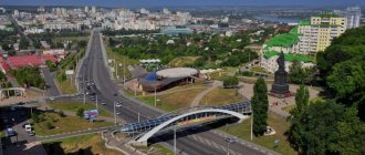
City of Vilyuchinsk
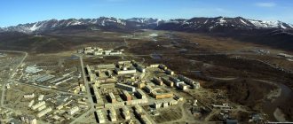
Few people manage to visit this city, because it is a closed settlement. Therefore, the only way to get to know the city is through photographs. Well, those who visited this and other cities of Kamchatka, which are intended for military personnel, will be pleased to remember these places.
Vilyuchinsk consists of three districts, which are divided among themselves:
- Primorsky is the largest; it is the so-called sleeping area.
- Seldevaya is an area where submarine docks are located.
- Rybachy is the area where the submarines themselves are based.
The city got its name from the volcano. Interestingly, Vilyuchinsky volcano is located very far away. Staying within the city limits, you can only see a small tip of this giant.
The first visit by Russians to the land of Kamchatka
In 1648, Fedot Alekseev Popov, together with Semyon Dezhnev Sea, went to the mouth of Anadyr on Kochs in search of new fishing areas. The ships were caught in a storm and Popov was separated from his companions. When his koch was washed to the ground, he turned out to be the first Russian explorer in Kamchatka. This became known 80 years later, when the Bering expedition rediscovered the passage between Asia and America.
In 1697, the Yakut Cossack Vladimir Vasilyevich Atlasov, together with Luka Morozko, undertook a study of the geography, climate, flora and fauna of the new land.
In 1700, he, already in Yakutsk, wrote down the information collected in detailed “skasks” (stories); At the same time he drew the first map of Kamchatka. A year later, having arrived in the capital, Atlasov presented a report on his campaign to the king. So Kamchatka was annexed to the Russian Empire.
History of Kamchatka
The oldest settlement found by archaeologists on Lake Ushkovskoye dates back to the Upper Paleolithic. 13-15,000 years ago, hunters and fishermen came here from the south. Perhaps this ancient Kamchatka culture, settling further to the east, found a passage to Alaska (in those days, overland).
In the southern part of the peninsula there are several Neolithic sites dating back to the second half of the 1st millennium BC, including unique burials. The objects found in them indicate that the peoples of America and the Far East have a common root.
Differences in natural conditions led to the formation of several types of economy. As a result, about 2-2.5 thousand years ago, the ancestors of the Itelmens, Koryaks, and Chukchi became isolated. Later, the Aleuts and Evens came to Kamchatka.
After Atlasov's campaign, the development of these lands began. In 1703, Roman Presnetsov found a huge and very convenient bay on the east coast - Avacha Bay. In 1740, the second Kamchatka expedition of Vitus Bering wintered here.
On October 17, 1740, the commander's packet boat entered the bay. This day began to be considered the date of the founding of Petropavlovsk-Kamchatsky. A year later, an expedition set off from here to the shores of America, in which Bering died.
The village, founded in Avachinskaya Bay, received self-government in the second half of the 18th century. The commander of Kamchatka Shmelev built fortifications and placed artillery batteries on commanding heights. The city became the base for the great geographical and astronomical expeditions of Cook, La Perouse, Sarychev, Krasheninnikov, Steller.
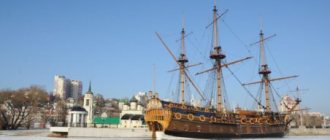
Monument to the Maksutov Battery in Kamchatka
In 1822, the administrative subordination of Kamchatka changed, and the settlement founded by Bering was included in the cities of the Russian Empire under the name Peter and Paul Port.
In 1850, a military governor of Kamchatka was appointed for the first time. It was V.P. Zavoiko; It was he who managed to organize the defense of the city during the Crimean War. This is one of the most heroic pages in the history of Kamchatka. A combination of English and French ships in 1854 stormed the city with forces five times greater than the Russian garrison. The main battle took place on Nikolskaya Sopka.
The enemies landed a landing force of 700 people who tried to break into the city. They were stopped by cannon batteries on the hill. The main blow fell on the 3rd battery under the command of Prince Maksutov, which was later called “Deadly” . When the battery was destroyed by fire from the ships, the surviving defenders went into hand-to-hand combat.
By that time no more than a third remained of the garrison, but the landing party was repulsed. Now on Nikolskaya Sopka, among other monuments, there is a model of the legendary 3rd battery. The Peter and Paul defense became a symbol of courage.
In the 20th century Kamchatka remained a base for military sailors, fishermen, and scientists. The first volcanic stations were founded here, the work of which marked the beginning of a new science about the Earth.
Climate and weather on the peninsula by month
The peninsular position, the surrounding seas, and the predominance of mountainous terrain are the cause of Kamchatka's extreme climatic heterogeneity and unstable weather. In summer, cold rain may fall amid the heat. In winter there are snowfalls in which a month's worth of precipitation falls in one day.
Kamchatka on the map of Russia depicting precipitation has the densest shading. No other region of Russia receives as much rain and snow as the foothills of the Eastern Range and the adjacent southeastern coast.
| Climate type | continental (Central Kamchatka Lowland) | monsoon (southeast coast) |
| Max. temperature, degrees Celsius | + 37 (Dolinovka village) | +30 |
| Min. temperature, degrees Celsius | -57 (Milkovo village) | -29 |
| Col. Precipitation, mm/year | 400 | 2500 |
| Wind speed, m/s | 40 | |
| Number of warm days per year (more than +20) | 55 (Kamchatka River basin) | 6 |
Thaws up to +5 are frequent. Spring arrives late and is usually cold and windy, with frequent rain. Along with summer, it lasts 3.5-4.5 months.
Volcanoes
The number of volcanoes, including active ones, varies depending on the classification used. Some researchers count up to a thousand of them, and the area occupied by them is estimated at 40% of the territory of the peninsula.
Volcanoes are part of the Pacific Rim. This is the name of the line running along the periphery of the Pacific Ocean, along which tectonic activity (the movement of lithospheric plates), manifested by eruptions and earthquakes, is concentrated.
The volcanoes of the Middle Belt were formed about 11-13 thousand years ago. Then, during the Holocene era, the area of volcanism began to shift eastward, forming the East Kamchatka volcanic belt; This is where most active volcanoes are located.
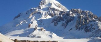
Klyuchevskaya Sopka is the highest volcano in Asia and is active. The last time it erupted was in 2013. The height of the hill, measured after the eruption, increased to 4835 m.
Elizovo
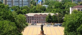
Elizovo is the second largest city in the Kamchatka Territory. People have settled and lived here for a long time. This is evidenced by the finds of traces of ancient sites on the banks of the local Avachi River. But the history of the modern settlement began in 1809, when the first settlers from Central Russia settled here. The main sources of income for the city budget of Elizovo are fisheries and tourism.
What interesting things can you see in this city? The only international airport and zoo on the peninsula are located here. In the vicinity of Elizovo there are 20 of the 29 active volcanoes. In the city you can buy original products made from deer fur and skin, and from walrus bones.
Rivers
Kamchatka on the map of Russia is densely indented by a network of rivers and streams flowing from glaciers in the mountains; The water in them is exceptionally clean and can be drunk without pre-treatment. There are more than 14,000 rivers here, most of them are less than 10 km long. The longest (758 km) is the river. Kamchatka, flowing in the eastern part and flowing into the Pacific Ocean near Ust-Kamchatsk.
In the upper reaches of the river they have a mountainous character, with numerous rapids and waterfalls. High flow speed (up to 4 m/s) due to erosion leads to the formation of holes and gullies at the bottom, the depth of which is much greater than the average (sometimes tens of times). In such places, the current speed is lower, and there are a lot of fish in them, especially under the upper edge.
It is convenient for the fish to rest here, since less energy is spent on overcoming the current. In the middle reaches, the rivers calm down and water content increases. Water flows often form bends around hard rocks. Where the flow speed decreases, extensive shallows, spits, and bars are formed, especially at the mouths. Alluvial material separates the channels, and old rivers are often found.
Lakes
The special water regime of the territory gives rise to enormous diversity among Kamchatka's 100,000 lakes. There are estuaries, lagoon, glacial, peat, tectonic, and volcanic reservoirs.
The area of the water surface ranges from 0.15 (Vasilkovskoe) to 550 sq. km (Nerpichye). Thermal springs feed lakes (for example, Khodutkinskoye) that fill depressions and craters. Rivers with hot waters flow from them. On Azhabachye Lake, one of the largest, sockeye salmon spawn en masse. In the Itelmen language this fish is called “azhaba”.
Blue lakes 38 km from Petropavlovsk-Kamchatsky are so called because of their unusually bright and pure color. Rare and protected species of orchids and rhododendrons grow in the vicinity of the lake. The exceptional beauty of the scenery and the proximity of the city make this place attractive for one- or two-day excursions.
Another beautiful landscape is the lake in Tolmachevo Dole, formed by an intermountain depression (lowering of the bottom). It is located at an altitude of more than 600 m above sea level and is surrounded by volcanoes of exceptionally regular shape.
The river flowing from it forms three waterfalls. Not far from the first one there is a lake. Bear Bowl, the water in which is turquoise, with a noticeable green tint. This is a maar filled with glacial waters, so its depth is very great, more than 250 m. A rare residential form of sockeye salmon, the cocoon, lives here.
Keys city
Kamchatka is a region where there are no large settlements. Therefore, the village of Klyuchi with a population of about 5 thousand inhabitants is called a city. It is located near the mouth of the Krutenkaya River, at the foot of Klyuchevskaya Sopka. The village of Klyuchi was founded in the place where the large Cossack fort of Nizhnekamchatsk was located. In 1731, it was burned down due to a riot raised by the Kamchadals.
Today, a volcano research station is based in this village, which operates under the leadership of the Institute of Volcanology of the Far Eastern Branch of the Russian Academy of Sciences. The city has regular bus service with Petropavlovsk-Kamchatsky. There is an airfield here, but it is used exclusively for aircraft transporting cargo. During the Soviet Union, passenger aviation also operated. Not far from the village there is the Kura missile test site. It is based in the swamps on the Kamchatka River and has been operating since 1955.
Flora of the peninsula
Features of the flora are associated with the island position of Kamchatka and its harsh winds and frosts:
- Exceptionally tall forbs, mainly grasshopper and cow parsnip. They grow more than 3 m; in such grass you cannot see a person, even if he is riding a horse.
- Elf trees made of cedar and alder are a serious obstacle for pedestrians. The branches of cedar grow downward, pressing the plant to the slopes, so it is better not to lose the path; getting out of the tangle of branches is long and very difficult.
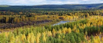
- Forests occupy about 1/3 of Kamchatka's territory. The main species is Erman stone birch. There are more coniferous and mixed forests in the Central Lowland. White Kamchatka birch, larches, and several types of spruce grow here.
Yelizovo city
It is here that the famous monument with bears and the inscription: “Russia begins here” is located. Elizovo is considered the most important city in Kamchatka in terms of transport links, especially for air vehicles. Despite its importance, residents of Kamchatka consider this city a transfer point on the way from Petropavlovsk to the main beauties of the peninsula, which are located in remote towns and villages. The lack of popularity among tourists is due to the fact that there are practically no attractions in the city. The only thing that distinguishes Yelizovo from a typical Kamchatka city is the incredible volcanoes that can be seen on the horizon.
Due to the fact that the city is considered an intermediate point, in it and its surroundings you can find many tourist centers, hotels, hotels and hostels, which are always ready to receive a large number of tourists. Comfort in them is at a high level, so both travelers from Russia and Europeans or Japanese, who often visit this area, will be satisfied.
Animal world
The same geographical and climatic reasons determined the diversity of animals. The fauna of Kamchatka has island features, since communication with the “hard land” is difficult. The narrow, up to 95 km, isthmus in Parapolsky Dol is swampy and often impassable. More than 900 species live in Kamchatka. Here you can find taiga, arctic, and alpine animals.
The Kamchatka variety of brown bear is the most impressive of the Asian subspecies. The weight of record specimens, the measurements of which are documented, reaches 400 kg, and in stories there are monsters weighing 6-7 c.
There are almost no reptiles or amphibians here, only one species of newt and a recently introduced frog (apparently an accidental introduction).
In coastal waters there are several species of small seals, which the local population calls seals.
Eared seals (fur seals, sea lions) on nearby islands gather in huge rookeries for breeding. Small groups of sea otters can be seen. On the east coast, pods of killer whales are often seen coming here to feed. This is the only species included in the Red Book, which is found in almost all cold and temperate seas. Like other marine primates, killer whales have a complex social structure and an extensive “language.”
Commercial fish were occasionally studied back in the 18th century. expeditions of Bering, Krasheninnikov, Steller. Systematic research into salmon, coho salmon, and sockeye salmon as a food resource began in 1925. In the 20th century. Fishing for another 26 species of fish has been developed. Fish production in Kamchatka in 2021 increased to 5 million tons.
Protected areas
In Russia, this status is given to areas in which any economic activity is prohibited. Depending on the severity of the restrictions, several types of OT are distinguished. On the map of Kamchatka they occupy 27%.
- Reserves.
- Biosphere Reserve on the Commander Islands founded in 1993 to preserve the rookeries of marine mammals, island forms of the Arctic fox, colonies of gulls, fulmars, hatchets, as well as traditional forms of environmental management of the Aleuts.
- The Koryak Nature Reserve has existed since 1995 on the territory of the Olyutorsky and Penzhinsky districts to preserve a unique natural complex - forest-tundra of the Beringian type. Here are the largest salmon spawning grounds and bird colonies; Rare and endemic species of animals and plants live (bighorn sheep, walrus, black-capped marmot).
- Kronotsky Nature Reserve , one of the oldest in Russia. In 1882, a sable reserve was organized here, and since 1934 it was transformed into the Kronotsky State Reserve; received biosphere status in 1985. It preserves integral biogeocenoses: Valley of Geysers, Kronotskoye Lake, Uzon Volcano, relict graceful fir forest, larch forests and spruce forests.
- Natural parks
The natural monument “Volcanoes of Kamchatka”, a UNESCO World Heritage Site, occupies more than 3 million hectares.
It united previously existing objects: Bystrinsky, Klyuchevsky, Nalychevsky, South Kamchatka natural parks, which now have the status of clusters. The Blue Lakes landscape natural monument, already described above, is a protected area of local importance.
- Natural reserves:
- "Coast of Chubuk" where hunting for bighorn sheep and brown bear is prohibited.
- “Bean”, a reserve for the Canadian beaver, whooper swan, and moose.
- “Zhupanovsky Estuary” protects places of concentration (during the autumn migration) of Anseriformes.
- “Ichinsky” maintains the population size of sheep, bear, marmot, and sable.
- “Nalychevskaya tundra” protects mass nesting grounds of mallards, whooper swan, and goldeneye.
- “Nalychevo Cape” was created to preserve the dense and vulnerable (due to the proximity of the city) population of Bighorn Sheep. About 10 species of Falconiformes, listed in the Red Book, live here.
- The Kol River is an experimental reserve created to preserve salmon numbers. The task of the reserve is to protect the places of their natural reproduction.
- "South Kamchatsky" around the lake. Kurilsky, a unique landscape natural monument.
Natural attractions
Avachinskaya Sopka
Coordinates: 53°15′ N and 158°51′ E
The most active volcano, Avachinsky, is located 30 km from Petropavlovsk-Kamchatsky. Translated from the Itelmen language, the name of the volcano is “fiery”. It belongs to the group of “home volcanoes”. It includes five volcanoes formed at different times: Aag, Arik, Kozelsky, Koryaksky and Avacha.
The maximum height of the double volcano Avachinskaya Sopka is 2751 m. The hill continues to grow. After a major eruption in 1991, the crater was filled with lava, the flows of which are layered due to activity. Today the volcanic cone is crowned by a crater 400 m deep.
Despite the constant activity, Avachinskaya Sopka is popular among mountain climbers. According to available data, the first conquerors of the volcano were three members of La Perouse’s round-the-world expedition in the 18th century.
Climbing to the top on foot takes 6-9 hours. The climb is steep in places. There are several rest points along the way to the top. And at an altitude of 1000 m there is an opportunity to spend the night.
Vilyuchinsky waterfall
Coordinates: 52.718466, 158.237086
On the northwestern slope of the volcano, as a result of the melting of the snowfield, a natural water cascade was formed. It falls noisily down from a height of 60 m and breaks through the thickness of the glacier. An underground stream flows underneath it.
It is dangerous to get close to the waterfall - the flow of water over the years has formed a steep ledge. The edges of the glacier are destroyed by water.
The waterfall is located a few km from the highway from Petropavlovsk-Kamchatsky. The area near the waterfall is rocky; the snow there does not melt all year round. The contrast of bright greenery and snow gives this place a mysterious feel. A walk to the waterfall is often combined with relaxation at the hot thermal springs, which are located on the other side of the Vilyuchinsky volcano.
In winter, the waterfall completely freezes and turns into a cascade of ice stalactites. Lovers of skiing and sledding come here.
Volcano Maly Semyachik
Coordinates: 54.119708, 159.661199
Old-timers say: smoke above the volcano means that deceased ancestors are heating their homes. According to legend, life is in full swing inside the volcano: the spirits of the dead feed on whale oil, which is extracted from animals living in the underground seas, and they also use it to illuminate their homes.
Today, tourists are attracted not only by the active Maly Semyachik volcano, but also by Trinity Lake located in the crater. The last eruption of the volcano was observed in 1952. Soaring is still observed above the summit.
One ridge of the volcano is deserted, the other is replete with bright greenery and streams. The height of the grass in these places reaches the waist.
If the weather permits, tourists have the opportunity, after climbing to a height of 1560 m, to descend into the crater of the volcano and approach the turquoise-colored sulfur lake. Descent is only possible with a safety rope.
The color of the lake is given by sulfur particles in the water, carried out by underwater fumaroles. The lake has recently begun to freeze in winter, which indicates a decrease in the activity of the volcano. In summer, the temperature of the reservoir reaches 400C. Sulfur fumes can cause severe poisoning.
The best time to visit this place is August, September.
Volcano Mutnovsky
Coordinates: 52.450053, 158.195149
The volcano is divided by the “Dangerous” ravine and consists of four craters painted in bright colors. The craters were formed as a result of explosions. The volcano, over which steam constantly rises, is so large that it can be seen from Petropavlovsk-Kamchatsky.
Despite the fact that the volcano is active, it has long been explored by mountain climbers. There are two ways to get to the volcano. First: walk 35 km from the Mutnovskaya geothermal station through the Dachnye thermal springs. The second is shorter, but more complex. It will require special skills and special equipment from travelers. The path is laid along the bed of a dried-up lake; you will have to overcome glaciers and sharp rocks.
As a result of constant volcanic activity, craters of varying depths are formed, which are immediately filled with melt water.
Karymskie waterfalls
Coordinates: 56°04′ N and 160°38′ E.
Hundreds of years ago, during the outpouring of lava, a high plateau was formed, from which the Karymsky waterfalls now descend. There are six of them, the tallest is 30 m.
Klyuchevskaya Sopka
Coordinates: 56°04′ N and 160°38′ E.
One of the most active volcanoes in Eurasia looks like a cone with ideal slopes. The highest point of the volcano is 4822 m.
Those who want to conquer the hill get to Klyuchi or Kozyrevsk. From Petropavlovsk-Kamchatsky the journey will take about 10 hours. Then, as part of an organized group, tourists get to the foot.
If tourists decide to travel the path to the foot of the volcano on foot, then they should be wary of bears. Climbing a volcano is an extreme form of tourism and requires special training.
Along the way you can visit caves, glaciers, a canyon in the Studenaya River, and the only edelweiss glade in Kamchatka.
You cannot stay at the top for a long time. The height, gases from the crater, and thin air make themselves felt: it becomes difficult to breathe, and your head begins to spin.
Klyuchevsky Natural Park
Phone: (8-41531) 7-24-00; 7-39-41 Website: https://www.vulcanikamchatki.ru/
The reserve covers an area of 376 thousand hectares and contains 13 volcanoes and 47 glaciers. The park includes the active Klyuchevskoy volcano. Its height is about 4800 m.
The volcanoes Kamen, Krestovsky, Ushkovsky, Klyuchevskoy, Sredniy bend around a flat glacier - one gets the impression of a huge natural dish.
Before visiting the Volcano Park, you must obtain permission and coordinate your route.
Commander Islands
Coordinates: 55°25' and 54°31' N 165°04' and 168° E How to get there: by plane from Yelizovo
200 km from the Kamchatka Peninsula in the southwestern part of the Bering Sea there is a group of four islands: o. Bering (the largest: length - 90 km, width - 18 km, population about 1 thousand people), o. Medny (length - 53 km, width - 5 km), o. Toporkov (area 0.25 km²), o. Aryan stone (53 m high rock).
The islands were discovered shortly after sailing to the shores of Kamchatka during the “Second Kamchatka Expedition” in 1741. While searching for new islands, the ship under the command of Vitus Bering suffered a tragedy - the ship washed up on a rocky unknown shore. Bering did not survive the winter and died in early December. Some of the crew survived and moved to the mainland on a homemade boat the following summer. Today this island bears the name of the legendary navigator Vitus Bering.
Medny Island got its name thanks to a large copper nugget that Emelyan Bassov picked up. The discoverer came ashore on the island in 1943.
The islands of Toporkov and Ariy Kamen were named after the birds that live on the islands.
Fur traders and sea animal hunters exterminated rare animals. The sea cow was completely destroyed.
Today, the nature of the islands and the adjacent marine area is under state protection. In 1993, the Commander State Reserve was established.
There are many small rivers on the Bering and Medny Islands, some ending in waterfalls. The height of the most spectacular ones reaches 100 m. Under the influence of winds on the island. Bering sand dunes formed. Their length is about 7 km.
Kronotsky Nature Reserve and Valley of Geysers
Coordinates: 54.438383,160.135913 Phone: +7-924-891-52-36 Website: https://www.kronoki.ru/territory/reserve/unique/1
The history of nature reserves in Kamchatka began in 1882. Thanks to the initiative of the inhabitants of the peninsula, it was possible to protect sables, reindeer and hundreds of other species of flora and fauna of Kamchatka from extermination. On the territory of the reserve there are: active volcanoes, numerous rivers and lakes, forests, coastal strip, swamps, glaciers, snowfields and dozens of geysers.
The Valley of Geysers, stretching in a chain along the eastern coast of the peninsula, was discovered in 1941. The gorge, 4 km wide and 400 m deep, stretches 8 km along the Geysernaya River. With a certain periodicity, powerful jets of steam and water erupt from the ground to different heights, and mud lakes bubble. In a limited area of land, all existing forms of hydrothermal activity occur.
The Valley of Geysers is a complex ecological system that is in constant motion. Natural processes occur that radically change the landscape of this territory. The last major natural disaster occurred in 2007. As a result of a large landslide, about a dozen geysers were filled up, new lakes were formed, and some basal rocks were destroyed. Self-healing of natural objects is now taking place. Most scientists agree that this process should be observed and studied, but not interfered with.
Tourist routes are organized to the Valley of Geysers, accompanied by a specialist and a reserve employee, which last several days. They are quite difficult and require physical training. You can get here as part of a tourist group by helicopter.
At the headwaters of the Geysernaya River there is a small piece of land, which is called the “Valley of Death”. Here, due to the accumulation of poisonous gases rising from great depths, animals and plants die en masse.
Kuril Lake
Coordinates: 51°27′18″N, 157°5′54″E
In the south of the peninsula, among the rocks, there is a freshwater volcanic lake. It is 12.5 km long and 8 km wide. Its depth in some areas exceeds 350 m.
The ecosystem developed more than 8 thousand years ago. The remote location of the lake contributed to the conservation of rare species of plants and animals. The largest herd of sockeye salmon in Eurasia spawns in the waters of the lake; it numbers several million individuals. The abundance of fish attracts brown bears, foxes and other wild animals to the shores of the reservoir.
The lake is home to a concentration of dozens of bird species. In good weather, volcanoes are reflected in the clear waters, and hot springs bubble up on the banks of the reservoir.
You can get here either by helicopter as part of an organized group, or by all-terrain vehicle.
Starichkov Island
Coordinates: 52.764666, 158.606876
The natural monument was named after one of the bird species living on the island - the old man. In the 18th century The island was used by sailors as a navigational landmark in Avacha Bay. Then they called him Vilyuchinsky.
Besides the old man, thousands of hatchets live there. This place was given the status of a nature reserve in 1981. There is practically nothing alive here. Among the rare plants that managed to survive in harsh conditions is the large bryozoan. About 70 plant species were also found there.
Resort towns in Kamchatka
- “Zelenovskie Ozerki” at the Pinachevskoye field, 20 km from the city of Elizovo, has equipped bathing facilities; the water is saturated with radon and hydrogen sulfide. Therapeutic baths can be recommended for children over 3 years old.
- Thermal baths on the river Paratunka. There are several groups of springs in the river valley, and the village. Paratunka has already turned into a balneological resort. Over the past 20 years, dozens of tourist centers, hotels, and individual guest houses have been built in the Paratunka recreational zone. Water contains a large amount of silicon.
- The vicinity of the Vilyuchinsky volcano and the valley of the river. Vilyuchi. Here groundwater comes out in two places. The temperature in the Nizhne-Vilyuchinsky springs reaches 62 degrees.
General information about the Kamchatka Territory
Distinctive features .
What do we know about Kamchatka? Back in school, this was the name given to the farthest desk, where you could hide from teachers, calmly go about your business, and even sleep. So in reality, it takes a long time to get to Kamchatka, and the one who ends up there feels like he has arrived at the ends of the Earth. From the same school lessons we know that Kamchatka is a land of volcanoes and geysers. We also know that this is where red caviar is produced, which has always been considered a delicacy, but more “democratic” compared to black sturgeon caviar.
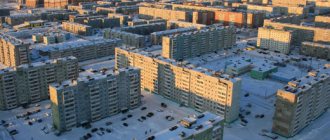
Vast areas of Kamchatka are very sparsely populated. More than half of the population are residents of Petropavlovsk-Kamchatsky. Besides it, there are only two cities in Kamchatka - Vilyuchinsk and Yelizovo. But they can also be considered suburbs of the same Petropavlovsk. The base of the Russian Pacific Fleet is located in Vilyuchinsk, so it has the status of a closed territory.
Despite its remoteness, Kamchatka attracts extreme tourists, photographers and scientists. Here is the highest volcano in Eurasia - Klyuchevskaya Sopka (4750 m), “Valley of Geysers” in the Kronotsky Nature Reserve. Not far from the east coast are the Commander Islands, which are also a unique natural reserve.
Volcano Klyuchevskaya Sopka. Photo by Georg (https://fotki.yandex.ru/users/georgs53/)
Geographical location . Just by the name alone it is clear that the Kamchatka Territory is located on the Kamchatka Peninsula. This is one of the easternmost regions of Russia, second only to Chukotka. The neighbors of the Kamchatka Territory are the Magadan Region in the west and the already mentioned Chukotka Autonomous Okrug in the north. Kamchatka Territory is part of the Far Eastern Federal District.
The shores of Kamchatka are washed by the Pacific Ocean. Of course, it is not so quiet, but on the contrary, quite harsh, especially in the northern latitudes. The western shores of Kamchatka are washed by the Sea of Okhotsk, and the eastern shores by the Bering Sea.
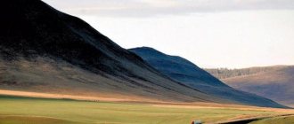
Most of Kamchatka's territory is covered with mountains and forests. The Sredinny Ridge, which is more than 900 km long, stands out especially. There is no taiga here, which is usual for Siberia; Kamchatka is separated from it by a tundra zone. Instead of taiga, here you can find unique forests of Kamchatka stone birch, which can never be confused with our usual birches of the middle zone - they are so upright to withstand the gusty Kamchatka winds.
Stone birch is one of the symbols of Kamchatka. Photo by Innochka (https://fotki.yandex.ru/users/cu-in/)
The population of the Kamchatka Territory is 320,549 people. Over the past 20 years it has decreased by two thirds. It seems that the turning point has been passed, and now the population of Kamchatka has stabilized. For the last four years it has remained at the same level.
Russians make up 78% of the region's population, with Ukrainians in second place (3.6%). The indigenous population - Koryaks - makes up only 2%.
Interestingly, the ratio of men and women in the Kamchatka Territory is approximately the same - 49%: 51%, and in most central regions of Russia the proportion of men is 2-3 percent lower.
Crime . The Kamchatka Territory is in 44th place in terms of crime rate. The cities are quite calm - there are military patrols and an older, conscious population. Poachers pose a big problem for law enforcement. Firstly, red caviar is a very tasty business that attracts various shady personalities, and secondly, hunting in nature reserves is also a pleasure loved by criminal elements. Another problem is corruption, which, as you know, is higher the further you are from Moscow. And from Kamchatka to Moscow - 11,900 km.
The unemployment rate in Kamchatka is not much different from the Russian average. In 2012 it was 5.83%. This is not so much, considering that 10 years ago it was twice as high. As for the income of the local population, the situation here is even better. The average salary in the region in 2012 reached 43,445 rubles. Unlike many regions of the Far North, the most profitable industry here is not oil and gas production.
Levels above average are shown by government administration (59 thousand rubles), production of electrical and optical equipment (52.6 thousand rubles), transport (51.5 thousand rubles), food production (45.6 thousand rubles .) and a number of other industries.
But you are unlikely to guess which of them has the highest average salary. This is... financial activity, where the average income is 81.7 thousand rubles. It’s interesting, if we assume that higher wages are associated with difficult working conditions in the Far North, then what kind of harsh conditions are observed, for example, among bank workers in Petropavlovsk-Kamchatsky? Do bears come into their departments every day? Or are they covered there with volcanic ash? Unclear.
Real estate value . Average cost of 1 sq. meter of housing in the capital of the region - 70 thousand rubles. A one-room apartment in Petropavlovsk-Kamchatsky will cost you about 2 million rubles. Two-room apartments are offered for 2.5 - 3 million rubles.
The climate of Kamchatka varies depending on latitude. In the north it is temperate continental, in the south it is temperate maritime. In winter, average temperatures are also different - from −9°C in the south to −24°C in the north. Winter in Kamchatka is very long, and summer is short and rainy, with an average temperature of +12..+16°C.
Valley of Geysers. Photo by victor.putnik (https://fotki.yandex.ru/users/victor-putnik/)
The peculiarity of Kamchatka is strong winds, snowstorms, hurricanes and storms. The southern part of the peninsula is particularly affected. This is due to the movement of cyclones coming either from Japan or from the Sea of Okhotsk. Also in the south there is heavy precipitation, reaching 1200 mm. In the north it is drier, about 300-400 mm per year.
Kamchatka is divided into several climatic regions - western, eastern, northern, mountainous and the Kamchatka River Valley. The most favorable climate is on the east coast, with relatively long summers and warmer winters due to warm cyclones from the Pacific Ocean.
Tourist potential of the peninsula
Participants in sociological surveys named Kamchatka one of the three most desirable tourist routes.
A huge number of people would like to see volcanoes, hot springs, bird colonies, rare animals, rafting down mountain rivers, fishing in the bays of the Pacific Ocean, riding a dog sled and even getting a driver's license, skiing down the slope of a hill, or climbing it. with your own feet to see the stunningly beautiful landscape.
Kamchatka on the map of Russia, replete with interesting and beautiful places, stands out for the novelty of its routes and the pristine nature of its natural sites.
Infrastructure has been developing rapidly recently. The potential of the peninsula is now impossible to even assess. But there are still few people who have been here. The main reason is that it is far away and expensive. The peninsula remains difficult to access, although airfare prices drop sharply in winter.
Features of Kamchatka
This is a unique peninsula, it is also called the land of volcanoes and bears. Only here you can look up close at an active volcano, swim in a hot spring, and walk on frozen lava. Magnificent views of the mountains and the bay, beautiful landscapes - all this attracts tourists.
If you decide to take a boat trip, you can see various inhabitants of the deep sea, bird colonies, and visit Starichkov Island, where many waterfowl birds nest:
- kittiwake;
- red-faced and Bering cormorant;
- slaty gull;
- Pacific guillemot and spectacled guillemot;
- thin- and thick-billed guillemot;
- an ordinary old man;
- molasses;
- axe.
Recreation and entertainment on the peninsula
Very different types of recreation are possible here, including for families with children:
- Excursions around the historical center of Petropavlovsk-Kamchatsky.
- Boat trips along Avacha Bay.
- Khalaktyrsky beach with volcanic sand.
- Local History Museum and Vulcanarium.
- Tours to volcano baths.
Attractions
There are dozens of beautiful, interesting places in the region. It will take a year to see everything.
But there are places that are especially popular with tourists:
- Avachinsky volcano;
- Avachinskaya Bay and the Three Brothers rocks;
- Valley of Geysers;
- Volcanic calderas in the Kronotsky Nature Reserve;
- Commander Islands;
- Tolbachik Volcano and Dead Forest;
- Kuril Lake;
- Blue Lakes;
- Acid lakes (Gorely and Maly Semyachik volcanoes);
- Klyuchevskaya Sopka;
- Salmon Museum;
- Kukhtiny Bati;
- Balneological resort (Paratunka village);
- Cruise on the expedition ship "Akademik Shokalsky".
Where to stay for a tourist, hotels, prices
In Petropavlovsk-Kamchatsky, accommodation in a double room in a middle-class hotel will cost a guest 4-6 thousand rubles. per day. There are twice as many hotels in Yelizovo, and prices are on average 20-30% lower (this does not apply to so-called facilities with a limited range of services).
Guests of Kamchatka recommend the following hotels:
- "Avacha";
- "Head of Kamchatka";
- "Bay House";
- "Three skis."
Mini-hotel on Partizanskaya, 31 offers accommodation for 3,000 rubles. At the Brusnika hostel the prices are even lower.
Other relatively cheap options:
- condominium "Russkii Dvor";
- cottage "On Chubarova 4".
A representative of one of the leading tour operators mentioned in an interview that Russian citizens know Antalya better than their own country. And not every one of them will be able to find the Kamchatka Peninsula on the map of Russia. But anyone who came here once will definitely want to return.
Article design: Mila Friedan
Kamchatka: cities (list and population)
As mentioned above, only every fifth resident of the Kamchatka Territory lives in villages. The cities of Kamchatka (there are only three) are small, two of them have less than 50 thousand inhabitants. There are many more villages and settlements in the region - 85.
All cities of Kamchatka are listed below. The population of each of them is indicated in brackets as of 2015:
- Petropavlovsk-Kamchatsky (181 thousand people);
- Elizovo (38.6 thousand people);
- Vilyuchinsk (21.7 thousand people).