What holiday is it today?
December 16, 2021, Thursday
Today are holidays, events: Events that happened on December 16 in the world, in different years Tomorrow: Day of Strategic Missile Forces Day of Employees of the State Courier Service Memorable date in the military history of Russia: Capture of the Ochakov fortress in 1788
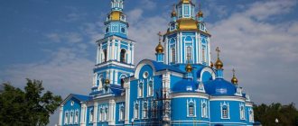
Today is the Orthodox holiday of the Prophet Zephaniah. Reverend Savva of Storozhevsky, Zvenigorod. Martyr Angelis... Tomorrow: Great Martyr Barbara and Martyr Juliania of Iliopolis. Venerable John of Damascus...
Today is a national holiday: Day of World Silence and Silence... Tomorrow: Barbarian Day...
Seasons
Seasons, four periods of the year (spring, summer, autumn and winter) characterized by certain average temperatures. The period during which the Sun passes through one of these sectors is called the season. Spring in the Northern Hemisphere and autumn in the Southern Hemisphere begin when the Sun passes through the initial circle of declination and its right ascension is 0° (vernal equinox). Summer in the Northern Hemisphere and winter in the Southern Hemisphere occur when the sun's right ascension is 90° (summer solstice). Autumn in the Northern Hemisphere and spring in the Southern Hemisphere begin when the sun's right ascension is 180° (autumnal equinox). The beginning of winter in the Northern Hemisphere and summer in the Southern Hemisphere is considered to be the winter solstice, when the direct ascension of the Sun is 270°... Next: Seasons. Russian folk calendar. Monthly words...
Geography
The Kaliningrad region is the westernmost region of Russia. Located in Central Europe. It is separated from the rest of Russia by the territory of other states, but is connected by sea and is thus a semi-exclave.
The maximum length of the region from west to east is 205 km, from north to south – 108 km. The length of the region’s borders, which are also the state border of the Russian Federation, is 540 km. Of these, 410 km are on land - approximately equally divided on the border with Poland and Lithuania and the 140-kilometer sea border along the Baltic Sea coast.
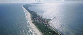
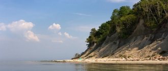
Curonian Spit
The sea coast of the Baltic Spit in winter.
The sand dunes of the Curonian Spit have a small absolute height - up to 30-40 meters, the highest dune is located near the village of Morskoye - 68 meters. To ensure the protection of the nature of the spit, the State Natural National Park “Curonian Spit” was established. The dunes of the Baltic Spit are slightly lower than the dunes of the Curonian Spit, their height usually does not exceed 40 meters.
The Curonian Spit has a length of 98 km, while the Kaliningrad region belongs to 48 km, the rest is the Lithuanian part. The width of the spit is from 400 meters to 4 km.
Baltic (Vistula) Spit
The length of the spit is 65 km, of which 35 km belongs to the Kaliningrad region, the rest belongs to Poland. The width of the spit is from 300 to 1800 meters.
The main natural resource of the region is amber. The Kaliningrad region is called the Amber Region, since more than 90% of the world's proven reserves of this amazing mineral are located on its territory. Amber is contained in sandy-clay deposits with an admixture of a bright green mineral - glauconite, which gives the rock a specific shade, which is why amber-bearing layers are called “blue earth”. The distribution area of the amber-bearing rock covers a significant part of the Kaliningrad Peninsula and adjacent areas of the sea shelf, as well as the western part of the coast of the Kaliningrad Bay. With distance from the coast, the depth of the rock increases, and the thickness of the formation decreases. Pieces of phosphorite are found along with amber. Currently, the annual production of amber reaches several hundred tons, but only a small part of it is used in jewelry production in the Kaliningrad region itself. The extraction and export of amber from the Kaliningrad region is often accompanied by offenses, such as illegal mining and smuggling of amber to Western European countries.
Amber is one of the symbols of the city and the Kaliningrad region, so its mention can be found in many names of enterprises, organizations, cultural events, and products of Kaliningrad manufacturers.
The region has several small oil fields onshore and offshore, including the Krasnoborskoye field operating in declining production mode (total reserves up to 11 million tons, commercial production began in 1975) and the largest Kravtsovskoye field in the Baltic (D6), located on shelf of the Baltic Sea with geological reserves of about 21.5 million tons, and recoverable reserves of about 9.1 million tons.
On the territory of the Kaliningrad region there are significant reserves of high-quality rock salt (first discovered in 1954) and peat (total reserves are about 3 billion tons, the largest deposits are Agilskoye, Nesterovskoye, Tarasovskoye, the total distribution area occupies more than a thousand square kilometers), brown coal reserves ( the largest deposits are Grachevskoye (up to 50 million tons) and Mamonovskoye). Peat is used primarily for agricultural purposes as an organic fertilizer.
The region provides itself with such building materials as sand, clay, gravel-sand mixtures; heavy sands containing titanium, zirconium and iron-manganese nodules have been identified off the coast of the region. Mineral waters with a high degree of mineralization located at great depths are widely used in the food industry and healthcare in the region. The region's resorts use local medicinal mud.
Climate
The climate of the Kaliningrad region is determined by its geographical location and is transitional from marine to temperate continental.
The influence of the Baltic Sea causes average annual temperatures to increase from 6.5 °C in the northeast of the region to 7.5 °C in the southwest. The maximum difference in average monthly temperatures is observed in January-February (up to two degrees). Usually the coldest month is January, but in February the air temperature differs from January by only half a degree. The warmest month is July (August is half a degree colder). The maximum air temperature in summer is 22–26 °C, the minimum temperature in winter is from −18 to −23 °C. The absolute minimum in the cities of Sovetsk and Nesterov was −35 °C, the absolute maximum (in Kaliningrad) was +37 °C.
It rains on average 185 days a year, snow - 55 days, cloudy 60 days, sunny 68 days.
Heat and frost in the region are short-lived, and snow cover does not last long. The average air temperature in the region is about +8 °C. The coldest month is January, the average temperature is +0.5… −4 °C, the warmest month is July, its average temperature is +17…+18 °C.
Annual precipitation varies across the region from 600 to 740 mm. In summer there is more precipitation than in winter; more in autumn than in spring. The maximum amount of precipitation falls in July and August (up to 100 mm), the minimum - at the end of winter and in April-May (35-55 mm). In spring and the first half of summer, long periods without precipitation often occur.
In autumn, westerly storm winds often pass over the region. The number of days with strong winds on the coast reaches up to 35. Thunderstorms in the area can occur throughout the year, although in winter they occur on average once every 10 years.
Hydrography
The region is washed by the waters of the Baltic Sea. In the north of the region there is a unique hydrographic object - the Curonian Spit.
Story
Starting from the 5th century, tribes of Prussians, a people related to the current Lithuanians and Latvians, lived on the territory of the current Kaliningrad region. By the 11th century, the Prussians lived in communities, engaged in agriculture, hunting, fishing and river (coastal) trade. The Prussians settled along tribal lines, building fortified settlements. They professed paganism.
After Poland adopted Christianity (966), active attempts were made to Christianize the Prussians. In 1206, Pope Innocent III issued a bull on the Christianization of the Prussians, and in 1217, Pope Honorius III declared a campaign against the Prussian pagans, which became part of the campaigns in East Prussia known as the Prussian Crusade, which were joined by the Teutonic Order in 1226. In 1230, the Pope gave the Teutonic Order the right to baptize the Prussians. The German crusaders, who had interests in eastern Europe, began to colonize new territories, which soon formed the state of the Teutonic Order. Colonization did not proceed peacefully - a considerable part of the Prussian leaders waged an active war with the crusaders, while some of the leaders converted to Christianity. The Teutonic Order gave certain privileges to loyal Prussians, integrating them into the feudal system of their state. During the main phase of colonization (XIII-XIV centuries), two major Prussian uprisings occurred - the first Prussian uprising (1242-1249) and the second Prussian uprising (1249-1260). During the uprisings, the Prussians remained divided, and despite significant difficulties, the crusaders managed to turn the tide of both uprisings and gain a foothold in the conquered territories.
During colonization, knights founded castles, which were their strongholds. Initially, the order's castle was a fortified house that served as the residence of the order's brothers. Such a house was built of wood and reinforced with a palisade. In the 14th century, the construction of castles in stone began. The first of them on the territory of the Kaliningrad region was the Balga castle, founded in 1239 on the shores of the Vistula Lagoon and preserved as ruins to this day.
Balga Castle in 1931
Prussian culture and the Prussian language gradually lost their importance - new feudal relations supplanted the traditional way of Prussian society, the German language became the language of trade and diplomacy. Most of the Prussians gradually assimilated, mixing with the mass of German colonists. Prussian speech survived as the language of rural communities until the 16th–17th centuries. Most of the non-Germanized Prussians switched to the Lithuanian language, receiving the name Letuvinniki (Prussian Lithuanians).
For security reasons, German colonists settled near the walls of castles, forming the so-called lischke. In this way, many cities and towns of the Kaliningrad region arose, including Königsberg (Kaliningrad). At the moment, on the territory of the Kaliningrad region there remains a significant number of historical monuments of the Prussian and Order period, which are mainly the ruins of castles and churches, the remains of ramparts and fortifications.
The state of the Teutonic Order waged constant wars with Poland and Lithuania, expanding its influence in the Baltic region. After the adoption of Christianity by Lithuania, the legal basis for the presence of the Teutonic Order in the lands of Prussia was exhausted, the flow of crusaders and funding from Germany began to gradually dry up. After the defeat at Tannenberg (Battle of Grunwald) in 1410 and the thirteen years of war that followed, the state of the Teutonic Order lost a significant part of its territories and was in a deplorable economic state.
In 1525, by order of Grand Master Albrecht, the Teutonic Order underwent secularization, and the state of the Crusaders was transformed into the secular Duchy of Prussia. The last Grand Master of the Teutonic Order, Duke Albrecht, became the first Duke of Prussia. The state religion of the new Prussian state was Lutheran Protestantism - thus, Prussia became the first state in the world to recognize Protestantism as its state religion.
The current governor of the Kaliningrad region Nikolai Nikolaevich Tsukanov
In 1657, Prussia became part of the united Brandenburg-Prussian state and freed itself from vassal dependence on Poland.
During the Seven Years' War, between 1758 and 1762, East Prussia was part of the Russian Empire. In German historiography, this period was called the “first Russian time.”
In accordance with the Potsdam Agreements of 1945, the northern part of East Prussia (approximately one third of its total territory) was transferred to the Soviet Union, the remaining two thirds were transferred to Poland.
Immediately after the Victory, the Koenigsberg Special Military District was organized, which also dealt with civilian affairs. On April 7, 1946, by the Decree of the Presidium of the Supreme Soviet of the USSR, the Koenigsberg Region was formed in the territory of the district as part of the RSFSR. On July 4, 1946, by Decree of the Presidium of the Supreme Soviet of the USSR, the Koenigsberg region was renamed the Kaliningrad region, and the city of Koenigsberg was renamed Kaliningrad. The mass resettlement of families of collective farmers and agricultural workers to the region was initiated by Resolution of the Council of Ministers of the USSR No. 1522 dated July 9, 1946, signed by Stalin. The document ordered the resettlement of 12 thousand collective farmer families “on a voluntary basis” to the Kaliningrad region for permanent residence in August-October 1946 from 20 regions and three autonomous republics of the RSFSR and from Belarus. As a criterion for selecting migrants, the government decree established the presence of at least two able-bodied members in each resettled family. The first echelon of collective farm migrants arrived in the Gusevsky district on August 23, 1946. The pioneers of large-scale migration were 715 residents of the Bryansk region, which was heavily damaged during the war. During the resettlement campaign of 1946-1948. In fact, residents of 27 regions of the RSFSR, four union republics, and two autonomous republics became migrants. The “trustworthiness” of the migrants was also taken into account, which was carefully monitored by the Ministry of Internal Affairs.
The German and Lithuanian (Letuvinniki - Prussian Lithuanians) population was deported to Germany by 1947. The first indigenous resident of the Kaliningrad region was Alexander Anatolyevich Dorofeev, born on July 4, 1946 at 0:01 a.m. in Tapiau (Gvardeysk) in the family of guard Major A. V. Dorofeev, hero of the battles for Königsberg and Pillau.
After the war, the Kaliningrad region became one of the most militarized territories of the Soviet Union. The headquarters of the Twice Red Banner Baltic Fleet is located in Kaliningrad; after 1991, the city of Baltiysk (formerly Pillau) remained the largest base of this fleet.
Folk calendar about every day
Every day one season always replaces another and this determines a person’s way of life. In connection with this, a folk calendar was formed in which there were practically no nameless, unmarked days. Every day was special, had its own purpose. All this was determined by climate conditions and astrological phenomena.
A calendar is a system for counting periods of time. The first calendars arose a long time ago, in ancient times, because there was a need to measure time. The word calendar comes from the Latin words caleo - to proclaim and calendarium - debt book. This is due to the fact that in Ancient Rome the beginning of each month was especially proclaimed, and because it was customary to pay debts on the first day of the month. Different peoples counted time differently. Some calendars are based on the changing phases of the moon - lunar calendars; in others - the change of seasons - sunny; in others, the length of the year was coordinated with the change of seasons, and the counting of months was associated with the phases of the Moon. Such calendars are called lunisolar.
In Rus', the calendar was called a monthly calendar. Every day, the month book covered the entire year of peasant life, “describing” day by day, month after month, where each day had its own holidays or weekdays, customs and superstitions, traditions and rituals, natural signs and phenomena. The cyclical nature of the calendar is reminiscent of human life, where spring is youth, summer is heyday, autumn is the time of harvesting fruits (it’s good if there are some, otherwise you can live your life without collecting fruits), winter is the time of wisdom and peace. This cyclicality and rhythm determined the way of life of the farmer. The folk calendar was an agricultural calendar, which was reflected in the names of the months, folk signs, rituals and customs. Even the determination of the timing and duration of the seasons is associated with real climatic conditions. Hence the discrepancy between the names of the months in different areas... Next: Folk calendar...
Kaliningrad
Climate
Winter in Kaliningrad The climate in Kaliningrad is transitional from maritime to temperate continental, with an abundance of cloudy days and precipitation. Thanks to the influence of the Gulf Stream - the world's largest warm current - winter in Kaliningrad is somewhat milder than in other cities at the same latitude, with frequent thaws and precipitation. Summer will appeal to those who cannot tolerate heat above 35 °C - such marks are rare here, and the average temperature in July-August is 22 °C.
Story
The history of the city on Pregolya can be divided into two main periods - Prussian-German and Russian - they are qualitatively different from each other, but are closely interconnected. Such a combination of such different historically significant cultures determines the unique and unique image of modern Kaliningrad.
Where did it all start? Mentions of the populated eastern shore of the Baltic Sea are found among many ancient Greek historians and date back to the 4th-3rd centuries BC. e. More developed southern civilizations called the inhabitants of the Pregolya valley “Estians,” which means “living in the east.” The Romans and Greeks were attracted by trade relations with local communities: for many centuries they sailed to these lands for the sun stone - amber.
Coronation of Frederick I, King of Prussia, in 1701
In the 9th century AD. e. The peoples living in the east gradually acquired the nickname “Prussians,” which is directly related to our ancestors. The fact is that after Kievan Rus joined European civilization, the inhabitants of the Baltic states ceased to be the most eastern people. They became those who live “before the Russians,” in other words, Prussians.
By the 10th century, at the confluence of the Pregolya River and the Baltic Sea, the permanent settlement of Tvangste took shape. Its inhabitants farmed on the fertile lands of the river valley, and also collected amber and sold it to foreign traders, whose ships visited the local port.
Old engraving depicting Konigsberg
The first turning point, which dramatically changed the vector of historical development, was in 1255, when the crusaders turned their attention to the wealthy trading town. The powerful Teutonic Order easily conquered peaceful lands and, as a sign of their power, founded Konigsberg Castle on the rocky shore. The name of the medieval fortress, which was later assigned to the city, is translated from German as “Royal Mountain”.
Königsberg in 1652
In subsequent decades, in order to avoid Prussian uprisings against the new government, the lands near the castle were actively populated by Germans, who successfully assimilated with the local people. The favorable location of Koenigsberg contributed to the growth of the city around the fortress and even the emergence of new settlements in the immediate vicinity. Thus, in 1300 Lebenicht appeared, which, although closely adjacent to the original buildings, had the status of an autonomous settlement. At the same time, Königsberg began to be called Altstadt (“old city”). In 1327, the duo of towns near Pregolya turned into a trio: they were joined by Kneiphof, a settlement on the island of the same name (now Kant Island), formed by the river and its tributary. This ensemble successfully existed until 1724, when it was united into a single city of Königsberg.
The year 1724 was notable for today’s Kaliningrad not only because of the long-awaited unification. On April 22, a boy was born into a completely ordinary family of artisans, who became the most famous and revered resident of the city. We are talking, of course, about the founder of classical German philosophy, Immanuel Kant, who lived his entire life in his native Königsberg, where he died at the age of 79.
During the Seven Years' War in 1758, the city was captured by the Russians and belonged to them until 1762, when Catherine II, who came to power, liberated the occupied lands as a sign of reconciliation.
Koenigsberg in 1850
Koenigsberg at the beginning of the 20th century
The 19th and early 20th centuries for Königsberg became a period of active cultural and economic growth. At this time, the city acquired a number of public and residential buildings in the Art Nouveau and Neo-Gothic styles, pleasing the eye with their natural lines and intricate patterns. Many gardens and parks with recreation areas appeared, and a railway station and one of the first airports in Europe called Devau (1919) were built.
On the night of November 9–10, 1938, which went down in world history as “Crystal Night,” the Jewish areas of Königsberg suffered at the hands of the Nazis who came to power. During mass pogroms and fires, the New Liberal Synagogue was completely destroyed - one of the most beautiful buildings not only in the city, but in all of Germany.
They started talking about restoring (or rather, building a new one on the site of the destroyed) Jewish shrine only in 2011.
In August 1944, the city suffered from British air raids as part of Operation Retribution: many architectural monuments, including Königsberg Castle, suffered significant damage.
Kaliningrad during the Great Patriotic War
On April 6, 1945, Soviet troops under the command of Marshal A. M. Vasilevsky came close to Koenigsberg. Fierce fighting continued for more than 3 days, but on the evening of April 9, the red banner was already flying over the city. The victory cost our army 3,700 lives, while the Germans paid for the loss with 42 thousand killed soldiers.
April 9, 1945 is the second, and, to date, the last, turning point in the history of Kaliningrad, marking the end of the Prussian-German period. Later that year, the heads of state of the anti-Hitler coalition decided to transfer East Prussia to the Soviet Union.
On July 4, 1946, the already domestic Koenigsberg was renamed Kaliningrad in memory of the great revolutionary and party leader M.I. Kalinin, whose monument to this day stands majestically on the square in the center of the city.
In 1946-1949. active deportation of the German population and settlement of the Kaliningrad region by Soviet residents took place here.
Fights on the city streets
The period of Soviet power for the culture and history of Kaliningrad can hardly be called favorable. At this time, monuments of German architecture and the heritage of ancient Prussia were actively destroyed. Among other things, in 1968, Königsberg Castle, whose walls had witnessed more than 700 years of the city's history, was completely destroyed. The main direction of development of Kaliningrad in the 20th century was the strengthening of industrial power and consolidation of the region as Russian territory.
After the collapse of the Soviet Union, Kaliningrad became the westernmost region of the country, its “representative” in Europe. Since 1991, the former Königsberg has been open to international economic and sociocultural relations. Honoring the history of bygone days, city residents are proactively restoring its historical appearance, which exudes a certain intelligence and high taste.
Kalinin Square. 1975
1981 Trestle bridge over Kneiphof (now Kanta Island)
Postcard from 1990 - a park on the site of a medieval city
Attractions
Every year hundreds of thousands of tourists visit Kaliningrad, and it is not surprising, because there are more than 500 cultural heritage sites, collected according to the principle of “a little of everything”. A variety of interesting places allows you to get acquainted with the history and unique cultural content of Kaliningrad in a relatively short time, enjoy the beauty of nature and relax on the friendly Baltic coast (provided that the traveler is not too lazy to spend an hour and a half on the road to the Curonian Spit, because in the very there is no sea in the city).
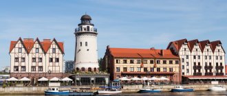
Amber Museum
The most famous attraction of the city is the Amber Museum, located on the shore of Lake Verkhnee on Marshal Vasilevsky Square, 1. The building itself - the Don Tower - is of considerable interest to tourists. This is a fine example of fortification architecture from the mid-19th century with elements of medieval decor, which visually makes the tower a couple of hundred years old.
The building of the Amber Museum in Kalingrad
Courtyard
The museum includes two groups of exhibitions: natural science and cultural-historical. Here, inquisitive tourists can not only receive comprehensive information about the origin and industrial use of this beautiful and mysterious mineral, but also enjoy ancient and modern collections of jewelry made from the “tears of the sea goddess Jurata.” Especially for the youngest visitors, employees regularly organize educational competitions, quizzes and master classes.
The Amber Museum in Kaliningrad is open to the public from May to September seven days a week, and from October to April on all days except Mondays. The cost of visiting is 200 rubles for adults, 100 rubles. – for students, 80 rub. - for schoolchildren. There are also a large number of preferential days, the schedule of which can be found on the website www.ambermuseum.ru.
Museum exhibits
Kaliningrad History and Art Museum
Kaliningrad History and Art Museum
You should start getting acquainted with the history of the city from the Kaliningrad Regional History and Art Museum, located on the shore of the Lower Pond (Klinicheskaya St., 21). The exhibition is divided into 5 thematic parts, each of which occupies a separate room:
- nature - description of the flora and fauna of the Kaliningrad region, ecosystems of rivers and numerous lakes. Here you can also enjoy an accurately recreated panorama of the Baltic Sea;
- archeology - the oldest chronicle of the surrounding area, from the times of the Vikings and ancient Prussians to the period of the conquest of territories by the Crusaders;
- the history of the region - the life of the region during the reign of the Teutonic Order and further, until the outbreak of World War II, here visitors can learn about the life, traditions and rituals of this era;
- war is perhaps the most emotional part of the exhibition, illustrating the difficult and tragic events of 1938-1945;
- “Horizons of Memory” is a story about the history of Kaliningrad as a Russian city, the peculiarities of the settlement of the region in the post-war period, the development of industry and culture in Soviet times.
This museum is open daily, except Mondays, from 10.00 to 18.00. The cost of visiting for adults is 60 rubles; there are discounts for schoolchildren and students.
Sculpture Park in Kaliningrad
The Kaliningrad Regional Museum of History and Art has a developed network of branches, a visit to which can reward tourists with many memorable impressions. It is recommended to visit at least the following:
- Museum "Dugout" (Universitetskaya St., 1) - located in the bomb shelter of the headquarters of the German troops. The exhibition reveals many unique and dramatic details of the storming of the city and post-war events: about the help of anti-fascist Germans, about the fate of civilians and the fate of prisoners of war, about the identification of unmarked graves from the Second World War.
- The Sculpture Park Museum (Kant Island or Central Island) is a favorite place for relaxation and evening walks. Here is a collection of 30 statues by different authors from all over the post-Soviet space. All sculptures are, in one way or another, connected with the life of the city. Each of them has its own story, which you can get acquainted with by booking a thematic excursion. If facts and legends are not of much interest to visitors, you can simply stroll along the shady alleys, enjoying the silence and species diversity of the arboretum, which is open to the public 24 hours a day.
Museum of the World Ocean
You cannot pass by the unique Museum of the World Ocean - the only marine complex of this scale in all of Russia. The main pavilion is located on the Peter the Great embankment, but branches also include historical and cultural exhibitions (Royal Gate, Frunze St., 112) and “Ship Resurrection” (Friedrichsburg Gate, Portovaya St., 39). The unique museum comprehensively introduces guests to the nuances of the relationship between man and the ocean: it presents collections of marine flora and fauna, including a beautiful aquarium, highlights the history of the study of world waters, displays the best examples of the Russian navy and much more. Details of the visit, cost and ordering of excursions can be found at world-ocean.ru.
Museum of the World Ocean
National Center for Contemporary Art
Kronprinz Tower
Also in Kaliningrad there are a number of other historical and other attractions worthy of the attention of tourists. The Baltic pearl will also please connoisseurs of the avant-garde - on the street. Litovsky Val, 39, in the 19th century fortress tower “Kronprinz”, is located the state center for contemporary art. This is the cradle of all the most extravagant and sometimes even slightly extravagant areas of creativity. By visiting here, a guest can attend a concert of experimental music, an informal meeting of artists or poets, various exhibitions, performances and master classes. The life of the center, like all contemporary art, is in full swing - international festivals, seminars and educational lectures for children and adults are constantly held here. Events are often free, and their poster can be found here ncca.ru/kaliningrad.
City Gate
Those who are attracted by architecture - the monumental trace of civilizations - will find it useful to know that, despite all the destruction and reconstruction, there is something to see in Kaliningrad. First of all, these are the 7 city gates - traces of fortifications designed to protect the settlement from enemies. To look at them, you will have to travel around the city quite a bit, but it is, of course, worth it.
1. Rossgarten Gate (1852-1855) - a typical example of fortification architecture, with turrets, an observation deck and embrasures on the outside.
2. The Brandenburg Gate was created in 1657, and in 1843 underwent a major restoration, despite which signs of the Gothic style with its pointed peaks are clearly visible.
3. Sackheim Gate - is a cultural and historical monument of national importance, made in the neo-Gothic style. Since 2013, the art platform “Gate” has been operating here, on the basis of which photo exhibitions, meetings of contemporary art figures, master classes and lectures are regularly organized.
Rossgarten Gate
Brandenburg Gate
Sackheim Gate
Ausfal Gate
4. Ausfal (exit) gates are the most modest gates of Kaliningrad in terms of architectural design, which is due to their “economic” purpose at the time of construction in the first half of the 17th century.
5. Railway gates (1866-1869) – previously one of the branches of the Königsberg railway passed under them, which lost its significance after the Second World War. Today, these gates symbolically separate the “1200 Guardsmen” memorial and a park recreation area.
Friedland Gate
6. Friedland Gate is the latest neo-Gothic gate-type structure in Kaliningrad, decorated with pointed peaks and sculptures of famous figures from the city’s German past. Today there is a municipal museum “Friedland Gate”, where tourists can get acquainted with the history of pre-war Koenigsberg.
7. Royal Gate - outwardly reminiscent of a small castle and is the most striking representative of the neo-Gothic style in Kaliningrad. In addition to the patterned turrets, guests are attracted to this gate by the cultural and historical museum, the exhibition of which tells about the foreign policy relations of the old city.
Railway gate
Royal Gate
Ruins of the Royal Castle and ancient streets
To feel the atmosphere of the first settlement built on the site of Kaliningrad back in the 13th century, you must definitely visit the ruins of the Royal (Konigsberg) Castle, now located on Shevchenko Street, 2. Unfortunately, almost nothing remains of the majestic fortress, but since the beginning of the 21st century there Active archaeological excavations are underway, thanks to which you can get acquainted with fragments of the ancient foundation and elements of the life of privileged persons of the Middle Ages. The open-air exhibition belongs to the Kaliningrad Regional History and Art Museum.
To create a complete impression of the pearl of the Baltic, it is worth strolling through the quiet streets of the old German districts, the best preserved of which are Amalienau and Maraunenhof. Here tourists will not find ancient fortresses or majestic monuments, but the small villas of the early 20th century, found everywhere here, very accurately reflect the aristocratic character of the city.
Ancient mansions in the areas of Amalienau and MaraunenhofCentral Park of Kaliningrad
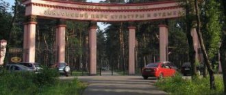
For active recreation and entertainment, you need to go to the Central Park, located at 1, Pobedy Ave. Here you can ride a Ferris wheel and enjoy bird's eye views of the city, visit the Puppet Theater, relax after a day full of new impressions in a cozy coffee shop or just eat sweets on a bench in the shade of trees. Also, Central Park has prepared many attractions and entertainment events for young and adult visitors.
Central Park of Kaliningrad
What tourists need to know
Kaliningrad is an extraordinary piece of our beautiful homeland, definitely deserving the attention of even experienced travelers. Here you don’t have to carry a dictionary with you everywhere, get into trouble due to ignorance of local traditions and customs, endure the pangs of acclimatization, and so on. But, as elsewhere, there are nuances, knowledge of which can make your holiday in this city as comfortable and relaxing as possible.
Accommodation
It’s worth taking care of where to stay in advance; our website can help you with choosing an establishment and booking rooms. Kaliningrad has an excellent selection of 3- and 4-star hotels, and the prices of apartments will pleasantly surprise tourists. Here you can also find cozy budget hostels. And to fully experience the atmosphere of an aristocratic city, it is worth renting one of the villas in the old German districts, the prices of which can hardly be called exorbitant.
Booking.com
Kitchen
There are absolutely no problems with food in Kaliningrad; here you can find everything - from street fast food to gourmet restaurants. The cuisine of the region consists of Russian national dishes, seasoned with German traditions. For example, Königsberg klops - in appearance they resemble ordinary meatballs, but once you try them, you can feel something overseas in the shades of taste. There is also an exotic dish in Kaliningrad - smoked Baltic eel - which tourists would be unforgivable not to try. You should also enjoy the delicate almond aroma of Königsberg marzipans.
Breakfast at the Croissant cafe
Tasting set
Königsberg marzipan
Street food festival in Kaliningrad 2021
What to bring as a souvenir
To remember the Baltic pearl of Russia, you should definitely buy amber jewelry. There are also a lot of fancy antiques here, smoked and dried fish are popular among visitors, and, of course, traditional souvenirs with the symbols of the city.
Amber jewelry is a popular gift from Kaliningrad
How to get there
The first question that requires the most attention is: how to get to Kaliningrad? The most convenient option is by plane; there are regular flights from many air terminals in the country. In this case, no additional documents are required to cross the foreign border. Khrabrovo Airport is located 25 km from the city and is connected to it by public transport.
Khrabrovo Airport
You can also get to Kaliningrad by train through the territory of Belarus or Lithuania. If the train is traveling through Belarus, passengers only need to have a ticket and a passport of a Russian citizen. To cross the Lithuanian border, you will additionally need a special permit, a request for which is automatically sent when purchasing a ticket. After 26 hours after issuing the travel document, it is necessary to find out whether the passenger was denied movement within the territory of the Baltic state. This can be done at the ticket office or information desk of Russian Railways. Unfortunately, there are no direct bus flights from the main part of Russia to Kaliningrad, so fans of this type of travel will have to travel with transfers in Minsk, Gdansk or Riga. Don’t forget about the documents that allow you to stay on the territory of Lithuania or Poland - Schengen or transit visas.
You can also get to Kaliningrad by ferry, which departs from the port of Ust-Luga (150 km from St. Petersburg) and arrives in Baltiysk (about 45 km from Kaliningrad), the journey this way will take an average of 38 hours.
Calendar of low prices for air tickets to Kaliningrad
Fishing calendar for every day
The fishing calendar should not be taken as an absolutely indisputable truth. Fish biting is greatly influenced by a whole range of natural factors, as well as the influence on the nature of man himself. You must not forget that the fish’s bite depends and is determined not only by the calendar dates and biological cycles of their life, reflected in the calendar, but also, no less, by the state of their habitat; the bite also depends on weather conditions: air and water temperatures, cloudiness, wind direction and strength, etc... Next: Fishing calendar...
general information
HomeKaliningradAdditional information
General information about the region
The Kaliningrad region is located on the southeastern coast of the Baltic Sea and is the westernmost region of the Russian Federation, completely separated from the rest of the country by the land borders of foreign states and international sea waters. In the north and east it borders with Lithuania, in the south with Poland. In the west, the 140-kilometer coast is washed by the waters of the Baltic Sea, which forms two bays: Curonian (1.6 thousand sq. km) and Kaliningrad - the Russian part of the Vistula Lagoon (0.5 thousand sq. km). The bays are separated from the sea by narrow strips of land - the Curonian Spit (48 km belongs to the Kaliningrad region) and the Baltic Spit - the Russian part of the Vistula Spit (65 km). The area of the region including bays is 15.1 thousand sq. km, land area is 13.3 thousand sq. km. km. Kaliningrad is connected to the open sea by a shipping canal (built at the beginning of the 20th century). The maximum length of the region from east to west is 195 km, from north to south - 110 km.
From Kaliningrad to the Polish border is only 35 km, to the Lithuanian border - 70 km. The nearest regional center of Russia - Pskov - is 800 km from Kaliningrad, and 1289 km from Moscow. The distances to many European capitals are relatively short: • 350 km to Vilnius, • 390 km to Riga, • 400 km to Warsaw, • 510 km to Minsk, • 600 km to Berlin, • 650 km to Stockholm, • 680 km to Copenhagen, • 850 km to Oslo, • 940 km to St. Petersburg; • 1230 km to Amsterdam.
The longest rivers: Pregolya - 123 km, Neman -115 km (across the region) The largest lake : Vishtynetskoye -18 square kilometers The highest altitude above sea level - Vishtynets Upland - 242 m As of 01.01. In 2006, the population of the Kaliningrad region amounted to 939.9 thousand people, of which 722.6 thousand people were city dwellers, 217.3 thousand lived in rural areas. Population density - 62.2 people per sq.m. The population of the region is multinational, there are representatives of 30 nationalities and nationalities. Among them, the most numerous are Russians - 78.1%. Belarusians - 7.7%, Ukrainians - 7.6%, Lithuanians - 1.9%, Armenians - 0.8%, Germans - 0.6%, Poles - 0.5%. Large cities: • Sovetsk (formerly Tilsit, 43.6 thousand people) • Chernyakhovsk (formerly Insterburg, 43.3 thousand people) • Baltiysk (formerly Pillau, 31.3 thousand people) • Gusev (formerly Gumbinen, 28 ,1 thousand people) Resorts: • Svetlogorsk (formerly Rauschen) • Zelenogradsk (formerly Kranz) • Pionersky (formerly Neukuren) • Otradnoe village Main industrial centers: • Kaliningrad, • Sovetsk, • Chernyakhovsk, • Gusev, • Svetly.
Geography and climate of the region
Most of the territory of the Kaliningrad region is lowland. In the southeast there is the Baltic ridge with heights of up to 230 m. Deposits of amber (one of the largest in the world), clay, gravel, rock salt, etc. The climate is transitional from marine to moderate continental. Average annual temperature is +8° C. Average temperatures in January are from -3 to -5 degrees C, in July +20 degrees C. Precipitation is about 700 mm per year. The Baltic and Curonian sand spits are separated from the sea by two large desalinated bays - Kaliningrad and Curonian. Large rivers: Neman (with the Sheshupe tributary) and Pregolya (with the Lava tributary). Numerous rivers, reclamation canals, 4 thousand lakes and ponds. The region is located in the subtaiga zone (mixed forests). Broad-leaved-dark-coniferous forests (oak, spruce, pine, birch, linden) occupy about 15% of the territory. In these forests there are brown hare, squirrel, marten, fox, roe deer, wild boar, etc. There are many birds. The waters are rich in fish. Bream, pike perch, smelt, and eel are found in the desalinated sea bays. In the sea - herring, sprat, smelt, salmon. The Curonian Spit National Park is located on the territory of the region. The Kaliningrad Bay is located on the southern coast of the Baltic Sea and is separated from the sea by the Baltic Spit, part of which is located in Poland, and at the coordinate 19° 38″ E. is the westernmost point of Russia. The Pregolya River flows into the Kaliningrad Bay, at the mouth of which Kaliningrad is located. The bay does not freeze in winter. The Curonian Lagoon is a lagoon off the southeastern coast of the Baltic Sea. It is separated from the sea by the Curonian Spit and connected to the sea by the narrow Klaipeda Strait. Length 93 km, avg. width 17.3 km, depth up to 7 m. The Neman River flows into it. It freezes in winter. The Curonian Spit is a sandy peninsula in Lithuania and Russia. Length 98 km, width from 0.4 to 3.8 km. Characteristic are dunes up to 70 m high, mostly covered with forests (pine, black alder with an admixture of oak, linden, elm). The natural conditions for the population's life are very favorable. Time (time zone in Kaliningrad)
Kaliningrad is located in the Eastern European time zone, which is + 2 hours GMT. When it is 12:00 in Kaliningrad, then it is 10:00 in London, 12:00 in Rome, and 13:00 in Moscow.
Transport
The region has all types of transport: sea, river, railway, air, road.
Air transportation
Kaliningrad Aviation Enterprise provides air communication between Kaliningrad and other cities of Russia, CIS countries, as well as a number of European countries. Domestic and international passenger and cargo air transportation is carried out through Khrabrovo Airport. The airport is located 24 km from Kaliningrad. There is a regular bus line between the airport and the city, the trip duration is 40 minutes. Air passengers are transported by: JSC KDavia, Aeroflot, Pulkovo, Krasavia, Belavia, LOT, etc. Currently, a regular airline is open (4 flights daily) Kaliningrad-Moscow-Kaliningrad (air Taxi). Polish airlines operate daily flights from Kaliningrad to Warsaw. The closest foreign international airport to the Kaliningrad region is in Gdansk (Poland).
Rail transportation
The Kaliningrad region has regular passenger rail connections with many Russian cities: Moscow, St. Petersburg, Veliky Novgorod, Petrozavodsk, Murmansk, Smolensk, Bryansk, Kursk, Voronezh, Rostov-on-Don, Krasnodar, Sochi and Adler, as well as with neighboring cities countries: Minsk, Brest, Vitebsk, Gomel in Belarus; Kiev, Chernigov, Kharkov, Simferopol, Zaporozhye, Odessa, Vinnitsa in Ukraine; Vilnius in Lithuania. Trains run daily to Gdansk and Berlin. In summer, direct transport links are additionally provided with Tula, Penza, Samara, Ufa and Chelyabinsk. The railway tracks of the Kaliningrad Railway (KZD) have exits to the states adjacent to the region: the Republic of Lithuania, the Republic of Poland. Since 2004, regular passenger rail service has been opened between Kaliningrad and Berlin. All intercity and international trains, as well as commuter trains, depart from the central (Southern) railway station, located on Kalinin Square (the area of three stations - the bus station, the railway station and the central Kaliningrad air ticket office). Domestic passenger transportation in the region is carried out by suburban trains to the resort cities of Svetlogorsk and Zelenogradsk, as well as to the cities of the region Baltiysk, Sovetsk, etc. You can also go to the resort cities of Svetlogorsk and Zelenogradsk from the Northern Station, located near the central Victory Square. For Russian citizens traveling by train to (from) Kaliningrad when transiting through Lithuania, it is necessary to have a Lithuanian visa or a simplified railway travel document (STR).
Water transport
The basis of the transport economic complex of the region is seaports. Maritime transport is represented by trade and fishing ports, Western River Shipping Company. In addition, about 20 enterprises have their own berths along the sea canal, in the Curonian and Kaliningrad Lagoons, on the Neman River (Sovetsk) and inland rivers. A regular ferry line connects the port of Kaliningrad with the port of St. Petersburg. The Georg Ots liner can carry up to 250 passengers and one hundred vehicles. Travel time is from 36 to 45 hours. Since October 2003, passenger service has been organized on the line "Baltiysk - Frombork", in 2005, ferries calling at the port of Baltiysk on the line "St. Petersburg - Baltiysk - German ports" increased to 5-6 times a week, a new line "Baltiysk - Klaipeda" was opened -Karlshamn (Sweden).”
Bus transportation
International bus transportation is carried out to the neighboring countries of Lithuania, Latvia, Belarus, Germany and Poland. Internal bus routes connect Kaliningrad with populated areas of the region. Basically, all routes start from the bus station, which is located next to the South Station.
Public transport
Public transport is represented by trams, trolleybuses and numerous bus routes. One-time tickets and travel tickets can be purchased at kiosks at bus stops and directly in transport from conductors. Public transport starts at 6 a.m. and ends at 10-11 p.m. The private taxi system is very well developed and varied.
Other useful information
- Kaliningrad: general information
- Flight schedule for 2021
- Train schedule 2021
- Entry of Russian citizens
- Curonian Spit
Thematic proposals:
Kaliningrad: Tour to Kaliningrad Amber mood 2021 Kaliningrad - Curonian Spit - Yantarny - Svetlogorsk
Many architectural and sculptural monuments, and unique museums await you here!
Kaliningrad: Tour to Kaliningrad Baltic Weekend
We invite you to a city where everything is a living testimony of European history
Kaliningrad: Tour to Kaliningrad “Four Stories” 2021 Kaliningrad – Yantarny – Svetlogorsk – Curonian Spit
Spend unforgettable days in a beautiful and unusual corner of Russia!
Kaliningrad: Tour to Kaliningrad - Prussian Week 2021 Kaliningrad - Curonian Spit - Yantarny - Svetlogorsk - Kaliningrad
Five days and all the most interesting things in Kaliningrad and its surroundings!
Kaliningrad: Winter Tour of Lake Baikal
Orthodox calendar about every day
Orthodox calendar: Orthodox, Church and Christian holidays.
The church year is an alternation of weekdays and holidays. On weekdays, a person is called to work “by the sweat of his brow to earn his bread.” Holidays are given in order to feel liberation, to rise above the bustle and routine of the world, to feel involved in the highest of worlds, “where there are no illnesses, sorrows and sighs, but endless life.” Since ancient times, holiday cycles have been associated with the seasons. The pagans associated them with the worship of the forces of nature, the cult of which in the Old Testament was replaced by gratitude to the Creator for the universe. And although the connection between holidays and the seasons has not completely lost its power, since God is present in everything, in the plant and animal world, in human works, it nevertheless faded into the background, giving way to a spiritual foundation built on the Sacred Scriptures. The history of Orthodox holidays dates back to the times of the Old Testament. Each of the Orthodox holidays is dedicated to the remembrance of the most important events in the life of Jesus Christ and the Mother of God, as well as the memory of saints... Next: Orthodox calendar...
Russian folk calendar for every day
The word “sign” comes from the word “notice”, i.e. observe. As a result of observing what happens around a person every day, he accumulates life experience. This knowledge was passed down from generation to generation, carefully preserved and people trusted it as a sacred book. Many signs have come to us from the depths of centuries without losing their knowledge. Each of us is free to choose: to dismiss all this as an absurd superstition or to take a closer look at the signs and take the centuries-old experience of generations more seriously. Most of us, when taking exams, ask them to scold them, boasting about some kind of good fortune or luck, spit so as not to jinx them or knock on wood, take a detour if a black cat crossed the road, are afraid of the number 13 and much more. And who among us does not have lucky things, numbers? Who has never resorted to the help of fate at least once in their life, who has not believed in secrets? It’s as if everything connected with signs is hidden somewhere deep in our subconscious. Often we remember them mechanically, unconsciously, or just as a joke. But, undoubtedly, the signs contain a lot of accurate knowledge and practical wisdom of our ancestors. They cover all the characteristic, often difficult to perceive, natural phenomena. Signs have preserved a lot of what was in old folk holidays and customs; they help predict the weather, grow crops... Next: Folk signs...
Kaliningrad on the map
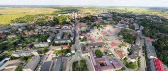
Let's start with the fact that this city is the administrative center of the Kaliningrad region. The population of the city is about 500 thousand people, and the region as a whole is slightly more than a million inhabitants.
Let's take a look at the map of Russia. That little pink piece over there, torn off from big Russia, is the Kaliningrad region. The westernmost region of the Russian Federation and, at the same time, not having common borders with it. Here is the westernmost point of Russia, and in general, no matter what you do, everything will be the most western.
Kaliningrad region on the map of Russia
Let's take a closer look. When approaching, it is clear that the Kaliningrad region is located in Central Europe, bordering Poland, Lithuania and washed by the Baltic Sea.
Holiday calendar, dates and events of the year
All state and professional holidays in Russia, including significant World and International holidays, and other equally interesting holidays and events about every day.
The holiday has always kept pace with the history of mankind. Social time can be divided into three types: everyday life (weekdays), weekends and holidays. Everyday life is a series of practices repeated day after day and every day (work). Weekends are regular breaks from the rush of everyday life. It is believed that on weekends a person should restore his strength after working days. Day off, non-working day. A holiday is a day of celebration established in honor or in memory of someone or something. A day or series of days celebrated by the church in memory of a religious event or saint... Next: Calendar...
What documents are needed to enter the Kaliningrad region?
As you have already understood, the Kaliningrad region is sandwiched between two Schengen countries (Lithuania, Poland) and the Baltic Sea. Therefore, if you want to come to Kaliningrad by land : by train or by car, then firstly you will need a foreign passport, and secondly, you will have to get a Schengen visa or a special transit document to travel through Lithuania.
However, if you arrive by plane from Russia, you don’t need anything, an internal Russian passport is enough.
Also, an internal passport will be enough if you travel to Kaliningrad by sea from St. Petersburg. True, this route is currently used for freight transport, but there is no regular and affordable passenger service by sea. We advise you to focus on the first two options.
Here is a complete article about how to get to Kaliningrad: by train, plane, car.
Prayer book, Orthodox prayers for every day
Prayer is the most powerful means for healing all illnesses - both physical and mental. Prayers can be laudatory or grateful, petitionary and repentant. If we have offended God, sinned, we must ask Him for forgiveness, that is, repent. Such prayers are called repentant prayers. If everything is fine with us, if we and our loved ones are healthy and prosperous, if we have a place to live, something to wear, something to eat, we must glorify and thank God for this. Such prayers are called praise or thanksgiving. If some misfortune, illness, trouble or need happens, you need to ask God for help. Such prayers are called petitionary... Next: Orthodox prayers...
Some more facts about Kaliningrad
What time zone is Kaliningrad in?
Kaliningrad time differs by −1 hour from Moscow time. That is, if in Moscow it is 12 o’clock in the afternoon, then in Kaliningrad it is 11 o’clock in the morning. This is standard time throughout the Kaliningrad region.
What is the sea like in Kaliningrad? Kaliningrad is washed by the Baltic Sea. Thanks to this, there are several small resort towns in the Kaliningrad region: Svetlogorsk, Zelenogradsk, Pionersky. Here we wrote in more detail about the features of a beach holiday in Kaliningrad. And here are the prices for holidays in Kaliningrad during the season.
What climate zone is Kaliningrad located in? Due to the fact that Kaliningrad is located on the shores of the Baltic Sea, its climate is influenced by the Gulf Stream. Winter here is much warmer than in mainland Eurasia. Summer is not too hot, which is optimal for people who cannot tolerate heat.
At what latitude is Kaliningrad? Kaliningrad is located at latitude 54 degrees and 42.4434 minutes. This parallel is called the “golden” parallel because it lies almost halfway between the north pole and the equator. It is believed that these latitudes have the most suitable amount of solar heat and daylength for life. The longitude of Kaliningrad is 20 degrees and 30.43842 minutes
What cities are near Kaliningrad? The border with Poland is approximately 50 km. large away . The capital of Poland, Warsaw , is 350 km away. The capital of Lithuania, Vilnius , is 340 km away. The capital of Germany, Berlin , is 620 km away. All these cities are accessible within a few hours by car. The Mediterranean Sea is approximately 1500 km or a couple of days by car.
Zodiac, astrological, eastern calendar. Zodiac signs
In ancient times, to establish the calendar, priests used knowledge of the positions of all the planets. Before the reform of Peter 1, the New Year was celebrated on the Day of the Autumn Equinox. On this day, according to ancient legend, the most peaceful treaty was concluded between the Great Race (ancient Slavs) and the Great Dragon (ancient Chinese) and it was approximately 7518 years ago... For the ancient Slavs, the calendar month corresponded to the lunar cycle from new moon to new moon, taking into account such Thus, the relationship of the entire annual cycle with astronomical and natural phenomena. There was no coherent calendar system. The main natural phenomena are still considered to this day to be the days of the solar equinox and solstice - the Slavic holidays Maslenitsa, Kupala, Ovsen and Kolyada. But during the time of Peter 1, all ancient Slavic calendars were abolished and a new Western European calendar from the Nativity of Christ (Julian calendar) was introduced, while the beginning of the calendar was moved to January 1. The Julian calendar (old style) did not take leap days into account and accumulated one extra day every 128 years. After the October Revolution in 1918, the Gregorian calendar (new style) was introduced in Russia, according to which an amendment of 13 days was introduced. The calendar of the ancient Slavs was based on two planets: the Sun and the Moon. And now they don’t use anything at all. The calendar has become static. There is no such thing as the calendar, it turns out, resting on some planet. Nobody even knows about it. There are just some standard numbers, there are months and holidays. The calendar is based on the Sun and Moon. Why is this so? Because these two luminaries influence the Earth. The Earth revolves around the Sun, and the Moon revolves around the Earth. And these two luminaries create the atmosphere on the planet. From here the calendar is built... Next: Astrological calendar...
Kaliningrad region
The Kaliningrad region is located on the southeastern coast of the Baltic Sea and is the western region of the Russian Federation, completely separated from the rest of the country by the land borders of foreign states and international sea waters.
The region was formed in 1945 after the decision of the Potsdam Conference of the three great powers - the USSR, the USA, the UK - on the liquidation of East Prussia, the northern part of which went to the Soviet Union after the Second World War.
In 1946, on April 7, the Presidium of the Supreme Soviet of the USSR adopted the Decree “On the formation of the Koenigsberg region as part of the RSFSR,” and on July 4, its administrative center was renamed Kaliningrad, and the region - Kaliningrad.
In the north and east, for 280.5 km, it borders with the Republic of Lithuania, in the south, for 231.98 km, with the Republic of Poland, in the west, the region borders the 183.56-kilometer Baltic coast. The maximum length of the region from east to west is 205 km, from north to south - 108 km. From Kaliningrad to the Polish border is only 35 km, to the Lithuanian border - 70 km. The nearest regional center of Russia - Pskov - is 800 km from Kaliningrad, 1289 km from Moscow, 940 km from St. Petersburg.
The region includes 9 municipal districts, 6 districts and 7 urban districts. The urban population makes up 77.7% of the total population. The average population density is 63 people per 1 sq. km. The most densely populated areas are Gusevsky, Chernyakhovsky, Bagrationovsky, Nemansky urban districts and Gvardeysky district.
Most of the territory is lowland. In the southeast there is the Baltic ridge with heights of up to 230 m. Deposits of amber (one of the largest in the world), clay, gravel, rock salt, etc. The climate is transitional from marine to moderate continental. Average annual temperature is +8° C. Average temperatures in January are from -3 to -5 degrees C, in July +15-17 degrees C. Precipitation is about 700 mm per year.
The Baltic and Curonian sand spits are separated from the sea by two large desalinated bays - Kaliningrad and Curonian. Large rivers: Neman (with the Sheshupe tributary) and Pregolya (with the Lava tributary). Numerous lakes.
The region is located in the subtaiga (mixed forests) zone. Broad-leaved-dark-coniferous forests (oak, spruce, pine, birch, linden) occupy about 15% of the territory. In these forests there are brown hare, squirrel, marten, fox, roe deer, wild boar, etc. There are many birds. The waters are rich in fish: in the desalinated sea bays - bream, pike perch, smelt, eel; in the sea - herring, sprat, smelt, salmon. The Curonian Spit National Park is located on the territory of the region.
The Kaliningrad Bay is located on the southern coast of the Baltic Sea and is separated from the sea by the Baltic Spit, part of which is located in Poland, and at the coordinate 19° 38″ E. is the westernmost point of Russia. The Pregolya River flows into the Kaliningrad Bay, at the mouth of which Kaliningrad is located. The bay does not freeze in winter.
The Curonian Lagoon is a lagoon off the southeastern coast of the Baltic Sea. It is separated from the sea by the Curonian Spit and connected to the sea by the narrow Klaipeda Strait. Length 93 km, avg. width 17.3 km, depth up to 7 m. The Neman River flows into it. It freezes in winter.
The Curonian Spit is a sandy peninsula in Lithuania and Russia.
Length 98 km, width from 0.4 to 3.8 km. Characteristic are dunes up to 70 m high, mostly covered with forests (pine, black alder with an admixture of oak, linden, elm). On April 7, 1946, the Koenigsberg region was formed as part of the RSFSR. After the war, the city began to be populated at a rapid pace, and production was restored. But the city had a semi-closed status due to its strategic location. The city was practically closed to foreigners, except for occasional visits of friendship from neighboring Poland.
Dream books online, interpretation of dreams
A dream book is nothing more than an interpreter of dreams and dreams, a translator of dreams. Since ancient times, people have been using dream books; dreams have always been given great importance, and people have often noticed the prophetic properties of some dreams. The dream book can become your faithful assistant every day and throughout your life, thanks to the dream interpreter you can always make the right decisions, the dream book will help you resist temptations in time, and will warn you against wrong steps and frivolous actions. Further…