Railway heritage
Nyandoma is located in the southwestern part of the Arkhangelsk region. The endless Nyandoma Upland stretches around. Its conventional borders are the Onega and Northern Dvina rivers. The glacier brought with it a huge amount of sand and clay and from this material built long ridges stretching from north to south. The heights here are small - up to 250 meters. This is the kingdom of the taiga.
Nyandoma is a station of the same name on the Konosha – Arkhangelsk railway line. The distance from Moscow is 790 km, from Arkhangelsk – 342 km. Since 2006, the settlement officially has the status of a regional center. It is curious that the entire city is divided into conventional districts, each of which has a “folk” name. There is “Vinegar Village”, “Tangshai”, “Fabrichny” and others.
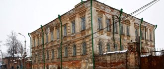
The station building at Nyandoma station. 1913
The local climate is not particularly warm. Winter can last up to 250 days and is accompanied by winds and cold. The average temperature in winter fluctuates around -26 degrees, in summer – plus 15 degrees. Snow falls at the end of October and can remain until the beginning of May. The weather is prone to sudden changes. The greatest amount of precipitation falls in autumn. Real spring comes in April.
Etymology of the city of Nyandoma
As for the name Nyandoma itself, it is not known for sure, but there are assumptions:
- The city got its name Nyandoma from a river of the same name flowing nearby.
- In Finno-Ugric the word "Nyandoma" means "rich land";
- In Sami “Nyammdeyavr” are glued lakes;
- In Karelian “Myandama” means “pine area”.
The inhabitants of this city are unofficially called “mamons”, where this name came from is also unknown, but there are also assumptions:
- Perhaps the Nyandoma people were nicknamed mamons, putting a certain meaning into this nickname, regardless of Savva Mamontov.
- A word from A.K. Matveev, professor at Ural University: “The nickname “mamons” means “gluttons.”
Museums and temples
In 1894, construction began on a narrow-gauge railway from Vologda to Arkhangelsk. A year later, they began to equip the station at one of the construction sites - they built dugouts, temporary huts and one permanent residential building. This is how Nyandoma was born. At the beginning of the last century there were about 30 houses in which 1,300 workers lived. Now the city's population exceeds 20 thousand people.
It’s better to start getting acquainted with Nyandoma at the local history museum. It is located in an old two-story wooden house. Of course, the main exhibition is dedicated to the history of the construction of the railway, which gave life to the city. There is a section dedicated to the ancient life of the inhabitants of the north. Household utensils, clothes, and old letters were collected from home by schoolchildren and teachers. The local forests are home to wild boars, bears, and moose. Stuffed animals and birds can be seen in the nature section.
Boots lined with wooden nails
Models of the depot, models of steam and diesel locomotives, special tools, and rare documents are kept in the Museum of Military and Labor Glory of the Nyandoma Locomotive Depot. An attraction is the ancient church of the Solovetsky wonderworkers Zosima, Savvaty and Herman. The temple was erected in 1896. No less beautiful is the modern chapel, which stands on the shores of Spassky Lake. It was built at their own expense by Valery and Nadezhda Savinykh.
The city has a Museum of Military and Labor Glory of the Nyandoma Locomotive Depot
Attractions in Nyandoma
The Church of Saints Zosima and Savvaty of Solovetsky is an Orthodox church made of wood, built in 1902, which was plundered during Soviet times, and only in 2000 began to function again.
The monument to the soldiers who died during the Great Patriotic War was erected in 1977. The stela and sculpture of a soldier remind people of their fellow countrymen who died defending their Motherland.
The EM-723-37 steam locomotive is a wartime locomotive. The monument was erected near the old station in 1989.
Nyandoma
The word “Nyandoma” translated from Finno-Ugric means “rich land”. The settlement, the future city, received its name from the small river flowing here and owes its existence to the construction of the railway in these places. In 1894, construction of the Vologda-Arkhangelsk narrow-gauge road began. The work was carried out by the joint-stock company of the Moscow-Yaroslavl Railway, headed by Savva Ivanovich Mamontov. In 1895, construction of the station began, a “residential building” was built, temporary huts and dugouts appeared. Workers cut down the forest and cleared the area for further development. In the autumn of the same year, the first rails were laid and construction of the station began.
In 1898, regular train service opened on the Vologda – Arkhangelsk line. There was no telephone connection; communication was carried out through the telegraph - the only means of communication at that time. Trains departed after receiving train telegrams, which were handed over to the locomotive driver and chief conductor against signature.
A settlement arose and expanded near the station. On May 19, 1901, a wooden church was founded here. By the beginning of 1902, the church was built and on January 21 it was consecrated by the dean priest Pavel Kazansky in honor of Zosima and Savvaty Solovetsky. In 1904, a narrow-gauge locomotive depot was built in Nyandoma, and new barracks were built. In 1905, the village had 28 residential buildings and was home to about 1,300 workers, about 300 of whom were temporary. The locomotive depot had 5 stalls, a forge and a mechanical workshop. Low-power German-made steam locomotives plied the railway; their average speed did not exceed 16 km/h.
In 1909, a telephone was installed at the railway station. In 1910, the village already consisted of more than 100 buildings, including: 50 residential buildings, a post and telegraph office, a church, an exemplary two-year school, 4 bakeries, a bakery, 4 grocery stores, a wine cellar, 5 tea shops with inns, a teahouse with a tavern, a beer hall and 2 butcher shops, a Singer sewing machine shop. But in the same 1910, Nyandoma was engulfed in a severe fire that destroyed almost all residential buildings.
On December 20, 1910, the telephone line stretched along the Nyandoma tract for 33 miles. In 1915–1916 The reconstruction of the Vologda-Arkhangelsk railway began, during which the narrow gauge was replaced by a wide one. These works required an increase in the number of workers and employees. Traffic on the new track was opened in January 1916.
Until January 1917, Nyandoma was part of the Andreevskaya volost of the Kargopol district of the Olonets province. From January 1917 to August 1929, the village was located in the Kargopol district of the Vologda province.
In 1922, a FZU school was opened at the Nyandoma depot (now the Nyandoma Railway College named after N. I. Shchetinin). In 1923, the Nyandoma station was merged with the Shenkursky village, inhabited by peasants, traders and artisans. The united village retained the name Nyandoma, and a Village Council was elected.
In 1925, the station village of Nyandoma was given the status of a workers' village. In 1928, the Zosimo-Savvatievskaya Church was closed. At the end of March, workers gathered on Church Square removed the domes from the temple. The church building was rebuilt and for a long time the District House of Children and Youth Creativity was located in it.
In August 1929, Nyandoma became the administrative center of the Nyandoma district of the Northern Territory and the Nyandoma district that was part of it. The population of the village during this period was 6,500 people.
In 1937, the Northern Region (until 1936 - the Northern Territory) was abolished, and its territory was divided into the newly formed Vologda and Arkhangelsk regions. The Nyandoma district became part of the Arkhangelsk region. By decree of the Presidium of the Supreme Soviet of the RSFSR dated September 19, 1939, the workers' village of Nyandoma was given the status of a city.
From 1963 to 1965 the city was the center of the Nyandoma industrial region as part of the Arkhangelsk region.
In 1960, public passenger transport appeared on the streets of Nyandoma. In 1965 there were 8 buses. In 1968, television appeared in the city. In 1971, gas was supplied to residents' apartments. In 1976, the Nyandoma Medical School opened.
In March 1997, work began on the electrification of the Konosha - Nyandoma section (length 89.3 km), which was completed on October 30, 1997 - on this day the first electric locomotive was welcomed in the city. In March 1998, electrification began on the Nyandoma – Plesetskaya section (126 km long).
Economics [edit]
Industry[edit]
The timber industry is the most developed industry in the region. The food industry is also present, represented, in particular, by broiler farming. [10]
Transport[edit]
Nyandoma is located on an asphalt road connecting Dolmatovo with Kargopol. This road also provides access to one of Russia's main highways, the M8, connecting Moscow and Arkhangelsk. Another paved road in a southerly direction connects Nyandoma with Konosha.
Nyandoma is also located on the railway line between Moscow and Arkhangelsk (built in a south-north direction).
Administrative and municipal status[edit]
As part of its administrative divisions, Nyandoma serves as the administrative center of Nyandoma District. [1] As an administrative division, together with three rural settlements it is part of the Nyandoma district as the city of district significance of Nyandoma
.
[1] In the municipal formation, the city of district significance of Nyandoma, together with the territories of Andreevsky, Burachikhinsky and Shozhemsky village councils (which, respectively, include nine, five and one rural settlements, a total of fifteen rural settlements) in the Nyandoma district are part of the Nyandoma municipal district as urban settlement Nyandomaskoye
. [5]
Climate[edit]
| Climate data for Nyandoma | |||||||||||||
| Month | Jan | Feb | Mar | Apr | May | Jun | Jul | Aug | Sep | October | But I | December | Year |
| Daily average °C (°F) | −13 (9) | −12 (10) | −6 (21) | 1 (34) | 8 (46) | 14 (57) | 16 (61) | 14 (57) | 8 (46) | 1 (34) | −5 (23) | −10 (14) | 1 (34) |
| Source: Weatherbase [13] | |||||||||||||
Links[edit]
Notes[edit]
- ^ abcdefgh State Committee of the Russian Federation on Statistics. Committee of the Russian Federation for Standardization, Metrology and Certification. No. OK 019-95 January 1, 1997 “All-Russian classifier of objects of administrative-territorial division. Code 11 244", ed. changes No. 278 / 2015 of January 1, 2021. (Goskomstat of the Russian Federation. Committee of the Russian Federation for Standardization, Metrology and Certification. No. OK 019-95 January 1, 1997. Russian classification of administrative divisions) (OKATO).
Code 11 244 , as amended by Amendment No. 278/2015 of January 1, 2016). - ^ ab Encyclopedia of Russian Cities
. Moscow: Great Russian Encyclopedia. 2003. p. 322 ISBN. 5-7107-7399-9. - ^ a b Federal State Statistics Service (2011). “All-Russian Population Census 2010. Volume 1" [All-Russian Population Census 2010, vol. 1]. All-Russian Population Census 2010 [All-Russian Population Census 2010]
. Federal State Statistics Service. - "26. The size of the permanent population of the Russian Federation by municipalities as of January 1, 2021". Federal State Statistics Service. Retrieved January 23, 2021.
- ^ a b c d e Law No. 258-extra-OZ
- "On the Calculation of Time". Official Internet portal of legal information
. June 3, 2011. Retrieved January 19, 2021. - Post office. Information and computing center of OASU RPO. ( Post office
).
Search for postal service objects ( postal Search for objects
) (in Russian) - ↑
Federal State Statistics Service of Russia (May 21, 2004).
“The population of Russia, the constituent entities of the Russian Federation as part of federal districts, urban settlements, settlements, settlements of 3 thousand or more people” [Population of Russia, its federal districts, federal districts, districts, urban settlements, rural settlements - administrative centers and rural settlements with a population of more than 3,000 people] (XLS). All-Russian Population Census 2002
. - “All-Union Population Census of 1989. The current population of union and autonomous republics, autonomous regions and districts, territories, negative phenomena, urban settlements and rural district centers” [All-Union Population Census of 1989: current population of union and autonomous republics, Autonomous regions and districts , territories, regions, districts, towns and villages performing the functions of district administrative centers. All-Union Population Census of 1989 [All-Union Population Census of 1989]
.
Institute of Demography of the National Research University: Higher School of Economics [Institute of Demography of the National Research University: Higher School of Economics]. 1989 - via Demoscope Weekly
. - ^ a b Nyandoma (in Russian). www.arhangelskobl.ru. Retrieved July 2, 2011.
- “Archival copy” Resolution of the Presidium of the All-Russian Central Executive Committee of July 15, 1929 on the composition of the districts and communications of the Northern Territory and their centers (in Russian). consultant.ru. Archived from the original on January 4, 2021. Retrieved June 12, 2011.CS1 maint: archived copy as title (link)
- Nyandoma Museum "Nyan's House" (in Russian). Russian Cultural Heritage Network. Retrieved July 2, 2011.
- "Weather Base: Historical Weather for Nyandoma". Retrieved September 24, 2013.