| Flag of Novomoskovsk (Tula region) | Coat of arms of Novomoskovsk (Tula region) |
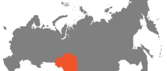
| A country | Russia |
| Subject of the federation | Tula region |
| Municipality | Novomoskovsk city |
| Former names | until 1933 - Bobriki until 1961 - Stalinogorsk |
| Telephone code | +7 48762 |
| Official site | https://www.nmosk.ru (Russian) |
| Ethnobury | Novomoskovsk residents |
| Timezone | UTC+4 |
| Postcode | 301650 (Main Post Office), 301660, 301670 |
| Chapter | Kozina, Elena Anatolyevna |
| Square | 76 km² |
| Day of the city | second Saturday in September |
| Population | ▼ 131,247[1] people (2010) |
| Center height | 240 m |
| City with | 1930 |
| Awards | |
| Vehicle code | 71 |
| Based | 1930 |
| Coordinates | Coordinates: 54°02′00″ N. w. 38°16′00″ E. d. / 54.033333° n. w. 38.266667° E. d. (G) (O) (I)54°02′00″ n. w. 38°16′00″ E. d. / 54.033333° n. w. 38.266667° E. d. (G) (O) (I) |
| OKATO code | 70 424 |
Novomoskovsk (before 1934 - Bobriki; from 1934 to 1961 - Stalinogorsk) is a city in the Tula region of Russia, the center of the municipal formation "city of Novomoskovsk".
The population as of January 1, 2010 was 131,247 people (125th place in Russia and second in the Tula region). The area of the city without adjacent rural areas is 76 km.
The city was founded in 1930 in connection with the start of construction of the largest chemical plant in the USSR. The city is located in the northern part of the Central Russian Upland between the Don and Shat rivers, 220 kilometers southeast of Moscow and 60 kilometers southeast of the regional center of Tula. Within the boundaries of Novomoskovsk is the source of the Don River. It is a major economic and industrial center of the Tula region, one of the cores of the polycentric Tula-Novomoskovsk agglomeration.
Geographic information
Novomoskovsk is located on the Central Russian Upland with a predominance of forest-steppe and steppe. The city was built between the Don and Shat rivers. Within the city limits is the source of the Don, at an altitude of 236 meters above sea level. On the territory of the urban district there are several large reservoirs that supply large enterprises with water, and one of them also breeds fish.
To the north of the city, 220 km is Moscow, and to the northwest (60 km) the regional center is Tula. The nearest settlements are in the south - Donskoy and Uzlovaya.
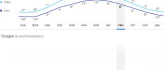
The region has a temperate continental climate with warm summers and not very cold winters. The coldest month is January with an average temperature of minus 6.8 °C, and the warmest month is July (plus 19.4 °C). In general, the weather is the same as in Tula. There is 614 mm of precipitation per year. The wind blows mainly from the south, west and south-west.
Novomoskovsk
(Tula region)
OKATO code:
70234501
Founded:
1929
City since:
1930 City of regional subordination
Center:
Novomoskovsk district
The city was formerly called:
| Beavers | 1929 | 1934 |
| Stalinogorsk | 1934 | 1961 |
| Telephone code (reference phone) | |
| 48762***** | 68-1-10 |
Deviation from Moscow time, hours:
0
Geographic latitude:
54°00′
Geographic longitude:
38°18′
Altitude above sea level, meters:
220 Sunrise and sunset times of the Sun and Moon in the city of Novomoskovsk
General information
Novomoskovsk is the administrative center of the municipal entity of the same name. Until 1934 it was called Bobriki, from 1934 to 1961 - Stalinogorsk. Area - 76 sq. km. In terms of population, Novomosskovsk is the second in the region.
The city district has developed chemical, energy, food and construction industries. More than 100 industrial companies operate here, including OJSC Novomoskovskaya Joint Stock Company, OJSC Orgsintez. The region is one of the largest in the country in the production of mineral fertilizers and chemical products. About 79% of the goods produced in the city come from this industry.
The Novomoskovsk railway junction was previously intended to transport workers from residential areas to industrial areas and out-of-town trips to the summer cottages of the population of Novomoskovsk. Now it carries out transportation both to the regional center and to neighboring regions.
Population
The population of Novomoskovsk (including the Sokolniki microdistrict), according to the Federal State Statistics Service, as of January 1, 2010, is 131,247 people, of which 45.1% are men and 54.9% are women. This is 125th in Russia and the second largest in the Tula region. The population of the municipal formation of the city of Novomoskovsk is 143,655 people.
City population dynamics:
| Index | 1897 | 1930 | 1931 | 1932 | 1933 | 1934 | 1939 | 1959 | 1970 | 1979 | 1989 | 2002 | 2003 | 2004 | 2005 | 2006 | 2007 | 2008 | 2009 | 2010 |
| Population (excluding suburbs) | 13 | 14,6 | 28,9 | 37,7 | 60 | 69,8 | 76 | 107 | 134 | 146 | 146 | 134 | 134 | 132 | 130 | 128 | 126 | 124 | 133 | 131,2 |
Early years
The first known settlement that appeared in this area was called Bobriki, after the name of the estate that belonged to Alexey Grigorievich Bobrinsky. He was the illegitimate son of the Russian Empress Catherine II and Count Grigory Orlov. The village in 1765 belonged to the autocrat.
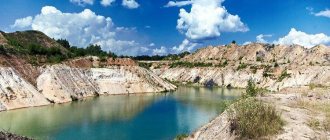
In 1850, coal deposits were discovered here, in addition, large deposits of red refractory clay and gypsum were explored. Thanks to these minerals, the presence of table salt and fresh water, this territory was chosen for the construction of a chemical plant.
In 1897, the population of Novomoskovsk was 13,000 people.
In 1929, one of the largest and most complex construction projects of the first years of Soviet industrialization began - the construction of a chemical plant. People arrived at the shock construction site from all regions of the country. In 1930, the city of Bobriki was formed with a population of 14,600 inhabitants. A year later, the population doubled, with 28,900 people living in it. In the pre-war years, the number of residents continued to grow rapidly, in 1939 the city's population was 76,186 people.
Map
| Novomoskovsk: maps |
Novomoskovsk: photo from space (Google Maps) Novomoskovsk: photo from space (Microsoft Virtual Earth)
| Novomoskovsk. Nearest cities. Distances in km. on the map (in brackets along roads) + direction. Using the hyperlink in the distance , you can get the route (information courtesy of the AutoTransInfo website) | |||
| 1 | Donskoy | 4 (9) | YU |
| 2 | Nodal | 9 (8) | Z |
| 3 | Dubovka | 15 () | SW |
| 4 | Kimovsk | 15 (24) | IN |
| 5 | Gritsovsky | 17 (11) | NW |
| 6 | Kireevsk | 25 (28) | Z |
| 7 | Bogoroditsk | 29 (37) | SW |
| 8 | Borodinsky | 31 (49) | Z |
| 9 | Bolokhovo | 32 (37) | Z |
| 10 | Tovarkovsky | 36 (49) | YU |
| 11 | Venev | 37 (58) | WITH |
| 12 | Lipki | 39 (49) | Z |
| 13 | Sovetsk | 44 (56) | Z |
| 14 | Oktyabrsky (Ryazan region) | 46 () | NE |
| 15 | Tula | 49 (52) | NW |
| 16 | Pervomaisky | 51 () | Z |
| 17 | Shchyokino | 51 (59) | Z |
| 18 | Mikhailov | 53 (67) | NE |
| 19 | Volovo | 53 (73) | YU |
| 20 | Plekhanovo | 54 () | NW |
| 21 | Serebryanye Prudy (Moscow region) | 57 (72) | NE |
| 22 | Leninist | 62 (67) | NW |
| 23 | Warm | 63 (69) | SW |
| 24 | Yasnogorsk | 65 (89) | NW |
| 25 | Kurkino | 68 (90) | YU |
| 26 | Plavsk | 74 (89) | SW |
| 27 | Zakharovo (Ryazan region) | 75 (92) | NE |
| 28 | Skopin | 84 (128) | IN |
| 29 | Pronsk (Ryazan region) | 85 (144) | IN |
| 30 | Miloslavskoe (Ryazan region) | 88 (163) | SE |
a brief description of
Located on the Central Russian Upland, in the Moscow region coal basin, at the source of the river. Don, 60 km east of Tula. Railway station.
Territory (sq. km): 888
Information about the city of Novomoskovsk on the Russian Wikipedia site
Historical sketch
It arose in 1929 on the site of the village of Bobriki (the former possession of the Bobrinsky counts) in connection with the construction of a chemical plant, new coal mines, a state district power station and the dams of the Lyubovsky and Shatovsky reservoirs. The name of the village is based on its location on the Bobrik stream, and the hydronym is based on the habitat of the animal beaver in this stream.
The city since 1930. Until 1934 it was called Bobriki. In 1934-61 - Stalinogorsk.
During the Great Patriotic War of 1941-45, it was occupied by Nazi troops from November 22, 1941. It was liberated on December 11, 1941 by troops of the Western Front during the Tula operation.
Since 1961 - Novomoskovsk. The name, obviously, comes from the city's location in the Moscow region coal basin.
Economy
Novomoskovsk is a major center of Russian production of mineral fertilizers and other types of chemical products.
Leading enterprises: PA - "Azot", "Novomoskovskbytkhim". JSC "Orgsintez", "Polymercontainer", "Gips", "Ogneupor", "Stroykonstruktsiya".
Factories: car repair, machine-building, Mayak (mine automation), food industry enterprises.
GRES.
In the Novomoskovsk region, grain crops, sugar beets, potatoes, vegetables, berries and fruits are grown. They raise cattle, pigs, and poultry.
Large Novomoskovskoe deposit of stone gypsum. Deposits of limestone and loam.
Main enterprises
CHEMICAL INDUSTRY
OJSC "Azot"
301670, Tula region, Novomoskovsk, st.
Svyazi, 10 Offers:
Mineral fertilizers, ammonia, organic synthesis products, chlorine, caustic soda, nitric acid, methanol
OJSC "Novomoskovskbytkhim"
301670, Tula region, Novomoskovsk, Komsomolskoye sh., 64
Offers:
synthetic detergents, varnishes on condensation resins
BUILDING MATERIALS INDUSTRY
JSC JV "Gips KNAUF"
301670, Tula region, Novomoskovsk, st.
Grazhdanskaya, 14 Offers:
Extraction of gypsum stone, production of gypsum products
MEAT AND DAIRY INDUSTRY
JSC "Zori Dona"
301670, Tula region, Novomoskovsk, st.
Novaya, 21 Offers:
Dairy and meat products
Culture, science, education
Branch of the Russian Chemical Technology University.
Drama Theater.
Museum of the History of the City.
Universities of the city
Moscow Social and Humanitarian Institute (Novomoskovsky branch)
301650, Tula region, Novomoskovsk, st. Labor reserves, 21
Novomoskovsk Institute (branch) of the Russian Chemical-Technological University named after. DI. Mendeleev
301665, Tula region, Novomoskovsk, st. Friendship, 8 WWW: https://www.nirhtu.ru/
Novomoskovsk branch of the University of the Russian Academy of Education
301650, Tula region, Novomoskovsk, st. Berezhny, 12 WWW: https://urao.nmsk.ru/
Museums, galleries, exhibition halls
Museum "Spasskoye" 301686, Tula region, Novomoskovsk, Spasskoye village, st.
Central, 4a Phone(s): (48762) 9-01-46 Website: https://www.museum-tula.ru/ Museum of the History of Novomoskovsk 301670, Tula region, Novomoskovsk, st. Komsomolskaya, 28 Phone(s): (48762) 6-0378 6-0304
Architecture, sights
Novomoskovsk consists of two main parts: the industrial northern part, and the residential southern part, separated from it by a 12-kilometer zone. In the southern part of the city there are cultural, administrative and commercial institutions.
40 km from Novomoskovsk, near the village of Gremyachee, there are karst caves.
| Population by year (thousands of inhabitants) | |||||||
| 1931 | 14.6 | 1979 | 146.8 | 2003 | 134.1 | 2014 | 128.0 |
| 1939 | 76.2 | 1982 | 147 | 2005 | 129.8 | 2015 | 127.2 |
| 1956 | 109 | 1986 | 147 | 2006 | 127.8 | 2016 | 126.5 |
| 1959 | 107.9 | 1989 | 146.3 | 2007 | 125.7 | 2017 | 125.6 |
| 1962 | 114 | 1992 | 145.4 | 2008 | 124.1 | 2018 | 124.8 |
| 1967 | 126 | 1996 | 142.9 | 2010 | 131.2 | 2019 | 123.2 |
| 1970 | 133.9 | 1998 | 141.0 | 2011 | 131.4 | 2020 | 122.3 |
| 1973 | 142 | 2000 | 138.1 | 2012 | 130.2 | 2021 | 121.7 |
| 1976 | 145 | 2001 | 135.9 | 2013 | 128.9 | ||
Modern times
Despite the short stay under German occupation, the inhabitants and the city itself suffered greatly. By the 50s, industry had finally recovered; in 1956, the population of Novomoskovsk was 109,000 people. The chemical plant was actively developing; in addition to chemical products, it began to produce mineral fertilizers. The city was actively being improved, new microdistricts, healthcare, sports and cultural facilities were built.
In 1986, the region became contaminated after the accident at the Chernobyl nuclear power plant. Since that time, the city has been in a period of crisis for a long time; only in 2007 did a gradual recovery of the economy begin. The population of Novomoskovsk has been declining in almost all recent years. In 2021, the city had a population of 125,647.
Architecture
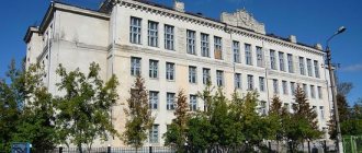
The central part of the city is characterized by a strict arrangement of streets running relative to each other at right angles according to the original development plan. The city center is Sovetskaya Square. Facing the square is the building of the Moscow Region Coal Research Institute. Next to it is a large four-story building with columns, which houses the municipal assembly and the administration of the city and district. The main street of the city, Komsomolskaya, runs through the square. A little to the east it is crossed by Moskovskaya Street, the widest in the city. Together, these two streets set the direction from the center and are a kind of “face” of the city.
The central area combines pre-war, post-war and modern architecture. Among the pre-war buildings, houses with arches, buildings in the constructivist style, for example, the building of the Pobeda cinema on the central square of the city, or a high-rise building with a colonnade on the street, stand out. Moscow. Famous architects, the Vesnin brothers, took part in the implementation of the construction plan.
During the Great Patriotic War the city was severely destroyed. German prisoners of war took part in the restoration of the city. Post-war buildings, in particular, include the building of the drama theater, the building of the city committee (now the city administration), two-story residential buildings built in the post-war years.
The streets are decorated with many green spaces.
Employment
The City Employment Center of Novomoskovsk is located at st. Sadovsky, 16. The institution implements measures to reduce unemployment, including assistance in informing city residents about available jobs and helping employers attract new workers. Currently there are the following vacancies at the Novomoskovsk Employment Center:
- low-skilled workers, including a customer service specialist, input operator, production and technical department engineer, with a salary of 15,000–20,000 rubles;
- semi-skilled workers, including an economist, a sorter of semi-finished products and products of the 3rd category, a specialist in drawing up and checking estimate documentation, with a salary of 25,000–30,000 rubles;
- highly qualified workers, including a car mechanic, instrumentation and automation engineer, process control system engineer, forwarding driver C, E with ADR, with a salary of 40,000 rubles.