Naryan-Mar
(Nenets Autonomous Okrug)
OKATO code:
11111
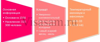
Founded:
1929
Urban settlement since:
1931
City since:
1935 City of district subordination
Center:
Nenets Autonomous Okrug
Telephone code (reference phone)
| 81853***** | — |
Deviation from Moscow time, hours:
0
Geographic latitude:
67°38′
Geographic longitude:
53°00′
Altitude above sea level, meters:
10 Sunrise and sunset times of the Sun and Moon in the city of Naryan-Mar
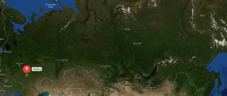
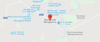
Map
| Naryan-Mar: maps |
Naryan-Mar: photo from space (Google Maps) Naryan-Mar: photo from space (Microsoft Virtual Earth)
| Naryan-Mar. Nearest cities. Distances in km. on the map (in brackets along roads) + direction. Using the hyperlink in the distance , you can get the route (information courtesy of the AutoTransInfo website) | |||
| 1 | Seekers | 7 () | NE |
| 2 | Ust-Tsilma (Komi Republic) | 247 () | YU |
| 3 | Usinsk | 268 () | SE |
| 4 | Izhma (Komi Republic) | 294 () | YU |
| 5 | Pechora | 335 () | SE |
| 6 | Inta | 358 () | SE |
a brief description of
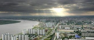
The city is located beyond the Arctic Circle, in the permafrost zone, on the Pechora Lowland, on one of the tributaries of the Pechora.
Sea port and river pier 110 km from the Barents Sea.
The climate is subarctic and harsh. Average temperatures in January are from -12 to -22, in July +6 +13. Precipitation is about 350 mm per year.
Territory (sq. km): 43
Information about the city of Naryan-Mar on the Russian Wikipedia site
Historical sketch
Originally the village of Beloshchelye, named for its location in the Beloshchelye tract, where the gap is a “steep terrace of the river; narrow valley, steep ravine.”
In 1929, construction of a timber mill began in this tract. The emerging village was officially called “a workers’ village at the Komiles sawmill N51 named after. Dzerzhinsky", or in short - the village named after. Dzerzhinsky. The name of the plant and village after the surname of the Soviet party and statesman F.E. Dzerzhinsky (1877-1926).
On October 10, 1931, the working settlement of Naryan-Mar was approved with the ideological name: Naryan-Mar - “red city” (Nenets naryan “red”, mar - “city”).
Since 1935 the city of Naryan-Mar.
Municipal indicators
| Index | 1990 | 1999 | 2001 | 2003 | 2005 |
| Demography | |||||
| Number of births, per 1000 population | 15.8 | 9.6 | 13.3 | 14.7 | 12.5 |
| Number of deaths, per 1000 population | 6.6 | 9.5 | 11.7 | 11.7 | 9.8 |
| Natural increase (decrease), per 1000 population | 9.2 | 0.1 | 1.6 | 3 | 2.7 |
| Standard of living of the population and social sphere | |||||
| Average monthly nominal accrued wages, rub. | 0.515 | 3400 | 9879 | 16563 | 24461.1 |
| Average housing area per inhabitant (at the end of the year), sq.m. | 13.4 | 18 | 19.2 | 19.1 | 20.5 |
| Number of preschool institutions, pcs. | 15 | 13 | 13 | 13 | 13 |
| Number of children in preschool institutions, thousand people | 1.891 | 1.742 | 1.682 | 1.706 | 1.810 |
| Enrollment of children in preschool educational institutions (at the end of the year), as a percentage of the number of children of the corresponding age, % | 93.4 | 84 | |||
| Number of daytime educational institutions (at the beginning of the school year), pcs. | 8 | 10 | 10 | 10 | 10 |
| Number of students in daytime educational institutions, thousand people | 3.6 | 4.3 | 4.3 | 4 | 3.6 |
| Number of doctors, people. | 98 | 99 | 119 | 120 | 134 |
| Number of nursing staff, people. | 327 | 325 | 319 | 340 | 284 |
| Number of hospital institutions, pcs. | 2 | 2 | 2 | 2 | 2 |
| Number of hospital beds, thousand units | 0.5 | 0.4 | 0.4 | 0.4 | 0.4 |
| Number of medical outpatient clinics, pcs. | 3 | 4 | 4 | 5 | 4 |
| Capacity of medical outpatient clinics, visits per shift, thousand units. | 0.390 | 0.470 | 0.540 | 0.552 | 0.553 |
| Number of registered crimes, pcs. | 760 | ||||
| Persons who committed crimes were identified, persons. | 353 | ||||
| Economy, industry | |||||
| Number of enterprises and organizations (at the end of the year), pcs. | 131 | 461 | 571 | 665 | 782 |
| Number of operating enterprises by type of activity: mining (at the end of the year), pcs. | 6 | ||||
| Number of operating enterprises by type of activity: manufacturing (at the end of the year), pcs. | 29 | ||||
| Number of operating enterprises by type of activity production and distribution of electricity, gas and water (at the end of the year), pcs. | 12 | ||||
| Volume of shipped goods of own production by type of mining (in actual prices), million rubles. | 3196.4 | ||||
| Volume of shipped goods of own production by type of manufacturing (in actual prices), million rubles. | 280.8 | ||||
| Volume of shipped goods of own production by type of production and distribution of electricity, gas and water (in actual current prices), million rubles. | 303.8 | ||||
| Construction | |||||
| Volume of work performed by type of activity “Construction” (until 2004 - volume of work performed under construction contracts), million rubles. | 0.012 | 81.204 | 309.103 | 3802.126 | 6301 |
| Commissioning of residential buildings, thousand sq.m. of total area | 9.8 | 3.1 | 11.4 | 8.7 | 28.8 |
| Commissioning of residential buildings, apartments | 42 | 174 | 122 | 418 | |
| Commissioning of preschool institutions, places | 380 | 0 | 0 | 0 | 0 |
| Commissioning of educational institutions, places | 0 | 0 | 0 | ||
| Commissioning of hospital facilities, beds | 0 | 0 | |||
| Commissioning of outpatient clinics, visits per shift | 0 | 0 | 0 | 0 | |
| Transport | |||||
| Number of bus routes (in intracity traffic), pcs. | 7 | 7 | 8 | 7 | 7 |
| Number of passengers transported by buses per year (in intracity traffic), million people. | 9.8 | 7 | 6.9 | 7.7 | 4.8 |
| Connection | |||||
| Number of telephone sets of the city public telephone network, thousand units. | 2.6 | 4.6 | 6.2 | 7.3 | 9.3 |
| Number of residential telephone sets of the city public telephone network, thousand units. | 1.1 | 3.3 | 4.7 | 5.1 | 6.6 |
| Number of payphones of the city telephone network (including universal ones), pcs. | 26 | 10 | |||
| Trade and services to the population | |||||
| Retail trade turnover (in actual prices), million rubles. | 270.8 | 646.8 | 1176.9 | 1909.1 | |
| Retail trade turnover (in actual prices), per capita, rub. | 10578 | 35055 | 45441 | 72588 | |
| Index of physical volume of retail trade turnover, % compared to the previous year | 109 | 117 | |||
| Index of physical volume of public catering turnover, % compared to the previous year | 111 | 133 | |||
| Number of stores, pavilions (at the end of the year), pcs. | 18 | 15 | |||
| Sales area of shops, pavilions (at the end of the year), sq.m. | 828.5 | 1028.8 | |||
| Volume of paid services to the population (in actual prices), million rubles. | 0.005 | 49.4 | 113.8 | 199.9 | 293.3 |
| Volume of paid services to the population (in actual prices), per capita, rub. | 0.2 | 1928.8 | 4464.7 | 7718.3 | 11153.7 |
| Volume of household services to the population (in actual prices), million rubles. | 0.002 | 4.770 | 10.050 | 19.0017 | 29.2558 |
| Volume of household services to the population (in actual prices), per capita, rub. | 0.069 | 186.3 | 394.1 | 733.7 | 1112.4 |
| Investments | |||||
| Investments in fixed assets (in actual prices), million rubles. | 0.023 | 385.4 | 5453.9 | 8925.8 | 19201.7 |
| Share of investments in fixed assets financed from budgetary funds in the total volume of investments, % | 22.7 | 7.1 | 3.8 | 3.9 | |
Data sources:
- Regions of Russia. Main characteristics of the constituent entities of the Russian Federation: statistical collection. Goskomstat of Russia. - M:, 2003.
- Regions of Russia. Basic socio-economic indicators of cities. Statistical collection. Rosstat. - M:, 2005. p. 115
- Regions of Russia. Basic socio-economic indicators of cities. 2006. Statistical collection. Rosstat. - M:, 2006. p. 115
Culture, science, education
Museum of Local Lore.
Museums, galleries, exhibition halls
Museum of History and Culture of Pustozersk 166000, Nenets Autonomous Okrug, Naryan-Mar, st.
Tyko Vylki, 4 Nenets Museum of Local Lore 166000, Nenets Autonomous Okrug, Naryan-Mar, st. Pobedy, 5 Phone(s): (818-53) 4-20-60 Website: https://www.naomuseum.ru/
Architecture, sights
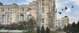
Since 1936, it was built up according to a regular plan (a rectangular street network with a square in the center), mainly with 2-story frame wooden houses.
Since the early 1960s, high-rise brick houses have been built in the central part of the city.
| Population by year (thousands of inhabitants) | |||||||
| 1926 | 14 | 1992 | 20.3 | 2008 | 19.3 | 2017 | 24.7 |
| 1939 | 13.7 | 1996 | 19.2 | 2010 | 19.8 | 2018 | 24.8 |
| 1959 | 13.2 | 2000 | 18.5 | 2011 | 21.7 | 2019 | 24.8 |
| 1967 | 15 | 2001 | 18.4 | 2012 | 22.4 | 2020 | 25.2 |
| 1970 | 16.9 | 2003 | 18.6 | 2013 | 22.9 | 2021 | 25.5 |
| 1973 | 17 | 2005 | 19.0 | 2014 | 23.4 | ||
| 1979 | 23.4 | 2006 | 19.1 | 2015 | 23.9 | ||
| 1989 | 20.2 | 2007 | 19.2 | 2016 | 24.5 | ||
Nenets Autonomous Okrug
Nenets Autonomous Okrug (Nen. Nenetsie autonomous okrug) is a subject of the Russian Federation. According to the Charter of the Arkhangelsk Region, it is also part of the Arkhangelsk Region, being a subject of the Russian Federation and at the same time an integral part of the region. It is part of the Northwestern Federal District. In accordance with the Charter of the Nenets Autonomous Okrug, the Okrug is an equal subject of the Russian Federation and has on its territory all the fullness of state power outside the jurisdiction of the Russian Federation and its powers on subjects of joint jurisdiction. The administrative center of the district is the city of Naryan-Mar (22,375 people). The district was formed on July 15, 1929. It borders in the west with the Arkhangelsk region, in the south with the Komi Republic, in the east with the Yamalo-Nenets Autonomous Okrug, in the north the border runs along the coast of the White, Barents and Kara seas, including adjacent islands that are not included in the jurisdiction of the Arkhangelsk region.
Geographical position
The Nenets Autonomous Okrug is located in the north of the East European Plain, most of which is located above the Arctic Circle. Includes the islands of Kolguev and Vaygach, the Kanin and Yugorsky peninsulas. It is washed by the White, Barents, Pechora and Kara seas of the Arctic Ocean. In the south the district borders with the Komi Republic, in the southwest with the Arkhangelsk Region, and in the northeast with the Yamalo-Nenets Autonomous Okrug. To the west of the Kara River there is the Kara meteorite crater with a diameter of 65 km.
Story
The first human settlements in the district date back to the 8th millennium BC. e. (Paleolithic). There are numerous sites from the Bronze Age (2nd-1st millennium BC). In the V-XIII centuries AD. e. Tribes of unknown ethnicity lived here, whom the Russians knew under the name “Pechera”, and the Nenets called “Sirtya”. This culture includes the Orty settlement, sanctuaries on the Gnilka River and on Vaygach Island.
The Nenets migrated to the territory of the district from the lower reaches of the Ob at the beginning of the 2nd millennium AD. e. Around the same time, the colonization of the extreme northeast of Europe by the Novgorodians began. Russian chronicles note the dependence of Pechora and Ugra on the Kyiv princes in the 9th century and the systematic collection of tribute. The final establishment of Novgorod's power over Pechora occurred in the 13th-15th centuries. After the annexation of Novgorod to Moscow (1478), the territory of the current Nenets Autonomous Okrug also passed to the Moscow state. In 1500, the military expedition of Prince Semyon Kurbsky founded the border fortress of Pustozersk on Pechora. This now defunct city for centuries was the administrative and commercial center of all lands from Mezen to the Urals.
Lower Pechora and the coast of the Barents Sea were developed, in addition to the Russians (Pomors) and Nenets, also by the Komi-Zyryans, Komi-Permyaks and Komi-Izhemtsy. In the 18th century, Pomors began settling the Kanin Peninsula.
In the 19th - early 20th centuries, the territory of the district was part of the Mezen and Pechora districts of the Arkhangelsk province.
In 1928, a decree was issued on the administrative centers of the Kaninsko-Timansky district of the Mezen district and the Telvisochno-Samoedsky district of the Pechora district of the Arkhangelsk province.
In 1929, the Nenets (Samoyed) district of the Northern Territory was formed. P. G. Smidovich and N. E. Saprygin took an active part in the creation of the district. The district from the Arkhangelsk province included: Kaninsko-Timansky district, Peshsky and Omsky village councils of the Mezen volost of the Mezen district, Telvisochno-Samoedsky district of the Pechora district. From Komi Autonomous District (Zyryan): Bolshaya Zemlya (tundra) of Izhmo-Pechora district. Thus, according to the Resolution of the All-Russian Central Executive Committee, the following composition of the Nenets District was approved: Kaninsko-Timansky District, with a center in the village of Nizhnyaya Pesha and the Nenets District (Bolshezemelsky), with a center in the Khoseda-Hard cultural base.
By decree of the All-Russian Central Executive Committee of December 20, 1929, changes were made to the administrative boundaries of the district: the Pustozersky volost of the Pechora district (with the exception of the Ermitsky village council) and the coastal islands were included, and a third administrative district was formed - the Pustozersky district, with its center in the village of Velikovisochnoe.
In 1931, the Pustozersky district was renamed Nizhne-Pechorsky, and its regional center was moved to the village of Oksino.
By decree of the All-Russian Central Executive Committee of March 2, 1932, the administrative center of the Nenets National Okrug, the Northern Territory, was moved from the village of Telvisochnoye to the working village of Naryan-Mar.
By a resolution of the Presidium of the All-Russian Central Executive Committee dated February 10, 1934, many islands located near the territory of the district were included in the Nenets Okrug, including Vaygach Island, as well as the territory of the Nessky village council of the Mezen region.
In 1940, the Amderma district and tundra councils were formed - Karsky, Yu-Sharsky and Vaygachsky (island).
In October 1940, the village of Vorkuta was transferred from the Bolshezemelsky district to the Komi Autonomous Soviet Socialist Republic.
In July 1954, Kolguev Island was assigned to the district.
In 1955, the Nizhne-Pechorsky district was abolished.
In 1959, all districts of the Nenets NO were abolished, and their territory passed into direct district subordination.
In 1977, the Nenets National Okrug was renamed the Nenets Autonomous Okrug.
In 1980, in the Nenets Autonomous Okrug, a gas release occurred at the Kumzha-9 well during drilling, after which a fire started. In May 1981, a nuclear charge was detonated at the field at a depth of about 1.5 thousand meters to shift geological layers, but the accident could not be eliminated, the field was mothballed.
In 1993, the Nenets Autonomous Okrug, in accordance with the Constitution of the Russian Federation, received the status of a federal subject.
In 2005, the Polar Region was formed in the Nenets Okrug.
Natural conditions
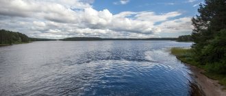
The terrain of the territory is mostly flat; The ancient Timan ridge and the Pai-Khoi ridge (height up to 467 m), and the wetlands of the Bolshezemelskaya and Malozemelskaya tundra stand out. The main river is Pechora. On the territory of the Nenets Autonomous Okrug there is a dense network of small rivers and small lakes, often connected by short channels. Tundra and peat-gley soils are common in the Nenets Autonomous Okrug.
Geologically, the territory of the Nenets Autonomous Okrug belongs to two Precambrian sedimentary plates of different ages: Russian and Pechora. The conventional boundary between them coincides with the zone of Western Timan deep faults.
The slabs have a two-story structure: the lower floor is an intensely dislocated folded foundation, the upper is a gently lying, weakly dislocated sedimentary cover. The formation of the crystalline foundation of the Russian Plate was completed already in the Middle Proterozoic, the folded foundation of the Pechora Plate - in the second half of the Proterozoic (Baltic folding). Both foundations, after their formation, underwent repeated transformations, were broken by faults, some sections rose, others, on the contrary, sank. The result of this is a very uneven surface.
Climate
The Nenets Autonomous Okrug belongs to the regions of the Far North.
The climate is universally subarctic, turning into arctic in the far north: the average January temperature is from −12 °C in the southwest to −22 °C in the northeast, the average July temperature is from +6 °C in the north to +13 °C in the south ; precipitation - about 350 mm per year; permafrost.
The Nenets District is subject to systematic invasion of Atlantic and Arctic air masses. Frequent changes in air masses are the cause of constant weather variability. In winter and autumn, winds with a southern component predominate, and in summer - northern and northeastern ones, caused by the invasion of cold arctic air onto the heated continent, where atmospheric pressure is low at this time.
The air temperature in summer is determined by the amount of solar radiation and therefore naturally increases from north to south. The average July temperature in Naryan-Mar is +12° C. In the cold half of the year, the main factor in the temperature regime is the transfer of heat from the Atlantic, so there is a distinct decrease in temperature from west to east. The average January temperature in Naryan-Mar is −18°C, winter lasts on average 220–240 days. The entire territory of the district is located in the zone of excess moisture. Annual precipitation ranges from 400 mm (on the coasts of the seas and on the Arctic islands) to 700 mm. The minimum precipitation is observed in February, the maximum in August - September. At least 30% of precipitation falls in the form of snow, and permafrost is present.
Hydrography
The territory of the district is washed in the west by the waters of the White Sea, in the north by the Barents and Pechora Seas, in the northeast of the Kara Sea, forming numerous bays - bays: Mezenskaya, Cheshskaya, Kolokolkovskaya, Pechora, Khaypudyrskaya, etc.
It is characterized by a dense river network (on average 0.53 km per 1 km² area) and an abundance of lakes. The rivers belong to the basins of the seas of the Arctic Ocean, are mainly flat in nature, and rapids on the ridges. It is fed predominantly by melted snow water (up to 75% of the runoff). Rainwater is of subordinate importance (15-20% of runoff), the share of groundwater is 5-10% or practically absent. The distribution of runoff has a pronounced seasonality with summer and winter low water, large spring and minor autumn floods. The duration of freeze-up is 7-8 months. By the end of winter, the ice thickness reaches 0.7–1.2 m, and small tundra rivers freeze to the bottom.
Among the rivers, the Pechora River occupies a special place; within the district there is its lower reaches (220 km) with an extensive delta. The depths allow sea vessels to rise to Naryan-Mar. In terms of water content, Pechora is second only to the Volga in the European part of Russia. Significant rivers are Vizhas, Oma, Snopa, Pesha, Wolonga, Indiga, Chernaya, More-Yu, Korotaikha, Kara, as well as tributaries of the Pechora - Sula, Shapkina, Laya, Kolva, Adzva.
Among the lakes, Golodnaya Guba (186 km²) and lake systems stand out: Vashutkinskoye, Urdyuzhskiye, Indigskiye, etc. Most lakes are small with a water surface area of up to 3 km² and average depths of 0.5-3 m, less often 4-5 m. Lake basins in mainly of residual glacial and thermokarst origin, in river valleys there are relict oxbow lakes. Swamps occupy 5-6%, on the coast up to 10-20% of the territory. Their depth is from 0.5 to 2 m. The main types of swamps are: hummocky (flat and large-hilly) and raised sphagnum ridge-hollows of atmospheric feeding, floodplain lowland ground feeding and transitional sphagnum. The thickness of peat deposits in hummocky bogs reaches 3-5 m. Groundwater, with the exception of the area of the city of Naryan-Mar, has not been sufficiently studied.
Land resources
The district's land fund as of January 1, 1999 amounted to 17,681,048 hectares. It is distributed into the following categories: agricultural land - 16,799.3 thousand hectares (95.01%); lands of settlements - 12.4 thousand hectares (0.07%); lands of industrial, transport and other non-agricultural enterprises - 39.8 thousand hectares (0.23%); lands for environmental purposes - 2.0 thousand hectares (0.01%); reserve land - 827.5 thousand hectares (4.68%). The area of agricultural land (hayfields, pastures, arable land) is 25.9 thousand hectares, or less than 0.15% in the structure of the district's land fund. 847.8 thousand hectares (4.8%) are occupied by forests, 1089.3 thousand hectares (6.2%) are swamps, and 1000.4 thousand hectares (5.66%) are under water. Reindeer pastures account for 13,202.2 thousand hectares (74.67%).
Soils
Depending on bioclimatic conditions, relief, the nature of soil-forming rocks, and the depth of surface water, the following main types of tundra soils are distinguished: arctic-tundra gleyic, tundra primitive, tundra surface-gley, peat-swamp, sod. Tundra podzolized illuvial-humus soils are formed on sandy and sandy loam soil-forming rocks under conditions of good drainage. Arcto-tundra gleyic ones are found on Vaygach Island and the coast of the Kara Sea, tundra primitive ones are found in the upper part of the slopes of Pai-Khoi, tundra surface gleyic ones, like peat-swamp ones, are widespread throughout the entire district. In the southwest of the district, in the subzone of the northern taiga, gleyic-podzolic soils and illuvial-iron-humus podzols are formed.
The soil-forming process is determined by low temperatures, short summers, widespread permafrost, waterlogging and develops according to the gley-swamp type. Chemical weathering is weak, while the released bases are washed out of the soil, and it is depleted in calcium, sodium, potassium, but enriched in iron and aluminum. Lack of oxygen and excess moisture make it difficult to decompose plant residues, which slowly accumulate in the form of peat.
Vegetation
The territory is located in the tundra (76.6%), forest-tundra (15.4%) zones, the southwestern part is in the northern taiga subzone (8%). In the tundra zone there are subzones of arctic (4.9%), mountain (3.5%), northern (10.3%), southern (57.9%) tundra.
In the subzone of the Arctic tundra (the coast of the Kara Sea and Vaygach Island), vegetation does not form a continuous cover. Frozen soil, exposed on dry ground from snow by strong winds, cracks, and the surface of the tundra is divided into separate polygons (polygons). The vegetation consists largely of mosses and lichens, grasses: small sedges, grasses, cotton grass, as well as slate forms of shrubs.
In the mountain tundra subzone, the main background is created by sedge-lichen associations and creeping shrubs of willow and dwarf birch.
The northern tundras cover the north of the Malozemelskaya tundra, in the Bolshezemelskaya tundra they are confined to large hills, the southern slopes of the Pai-Khoi ridge. Here the moss and lichen cover are closed, thickets of dwarf birches and low-growing species of willows appear. Significant areas are occupied by grass-sedge bogs; in the valleys of rivers and streams there are willows and tundra meadows with abundant multi-species forbs and grasses.
In the southern tundra subzone, large areas are covered with thickets of dwarf birch (birnie), as well as various types of willows, wild rosemary, and juniper. Moss or shrub cover is developed, shrubs, forbs, and marsh plant complexes are widely represented. In the forest-tundra zone, sparse forests appear on watersheds, and in river valleys and on the southern slopes of hills, woody vegetation appears in islands: low-growing spruce and birch trees, less often larches, alternating with areas of tundra and swamps.
The northern taiga subzone is characterized by the presence of significant tracts of closed tree vegetation with a predominance of spruce and spruce-birch forests; pine grows along sandy river terraces and in swamps. In river floodplains, areas with impenetrable thickets of various types of willow and alder alternate with sedge bogs and meadows. Grasses (reed grass, bluegrass, foxtail grass, red fescue) with an admixture of forbs grow on tundra meadows and laidas.
More than 600 species of flowering plants, several hundred species of mosses and lichens are found in the district. In coastal sea waters, macrophytes, which are represented here by algae (about 80 species), are dominated by brown algae, in rivers and flowing lakes - sedge, horsetail and arctophila. Blue-green diatoms dominate in river phytoplankton, and green and diatom algae dominate in lakes.
Species of northern groups are widespread in the flora, and taiga (boreal) species are quite widespread. Among the flowering plants, cereals, cruciferous plants, sedges, and willows predominate. With anthropogenic impacts on the vegetation cover of the tundra, shrubs, mosses and lichens are replaced by grasses, forming a secondary vegetation cover. The largest areas with secondary vegetation are found in the Bolshezemelskaya tundra, in areas of geological exploration and oil and gas production.
The flora is rich in a variety of food plants: berries, edible herbs. The most important are cloudberries, blueberries, lingonberries, blueberries, and crowberries. In the forest-tundra zone, along river valleys and in the taiga zone, red and black currants, honeysuckle grow, and raspberries, strawberries, and rose hips are found. In warm years, bird cherry and rowan ripen, and in the south of the Malozemelnaya tundra and in Kanino-Timanya - cranberries. Sorrel, wild onion and other meadow plants are used for food.
The resources of forage plants of floodplain meadows are rich - cereals, legumes, forbs, sedges; There are significant reserves of lichens in reindeer pastures - Cladonia, Cetraria; Medicinal plants grow everywhere.
More than 100 species of cap mushrooms are found in the district. Their species composition increases in the direction from north to south. In the northern tundra, edible mushrooms include russula, boletus mushrooms, boletus mushrooms, and dry milk mushrooms; to the south, aspen mushrooms appear; in the forest-tundra and taiga, milk mushrooms, saffron milk caps, white milk mushrooms, and others appear.
Animal world
Represented by inhabitants of the tundra, taiga, and arctic deserts. There are numerous aquatic invertebrates: ciliates, phytomonads, oligochaetes, nematodes, rotifers, lower crustaceans, mollusks, etc. The species composition of insects is diverse, with a huge number of blood-sucking insects: mosquitoes, midges, and gadflies. Among the cyclostomes, the lamprey is found. There are more than 30 species of fish in rivers and lakes. Among the migratory species are salmon, omul and others; semi-anadromous - nelma, whitefish, vendace; Among the aquatic (local) species are pike, ide, sorog, perch, burbot, peled, grayling and others. In the coastal seas - herring, navaga, flounder, cod, smelt and others (about 50 species of marine fish).
Amphibians include the grass frog, Siberian salamander, and common toad, and reptiles include the viviparous lizard. The species composition of birds is diverse - about 160 species, including 110 species of birds nesting in the area. About 20 species overwinter. In terms of species richness and abundance, the most represented are passerines and charibiformes (waders) - more than 40 species each, and waterfowl - about 30 species. Geese, ducks, and also ptarmigan, one of the background species of the tundra and forest-tundra, are of commercial importance.
There are 31 species of land mammals. The most numerous rodents are lemmings (Siberian and ungulate) and voles (water, housekeeper, Middendorf, narrow-skulled); squirrels are found in the taiga. Among other groups of mammals, the Arctic shrew and the mountain hare are common; Among the predators are arctic fox, wolf, fox, wolverine, brown and polar bear, marten, otter, ermine, weasel; among artiodactyls - wild reindeer and elk.
In the coastal seas, marine mammals are found: beluga whale, North Atlantic porpoise, narwhal, ringed seal, bearded seal, gray seal, Atlantic walrus. Among terrestrial mammals, the main fish species are arctic fox, fox, brown bear, marten, otter and elk. Of the marine mammals, only the ringed seal and bearded seal continue to be fished. A number of species are acclimatized in the district. Of the rodents, this is the muskrat, which spread widely throughout the territory and was the object of hunting; among fish - sterlet, but its population remains very small. Single specimens of pink salmon acclimatized in the Barents Sea basin come to spawn.
Minerals
The district has large oil and gas reserves, as it is located in the northern part of the Timan-Pechora oil and gas province, which is in 4th place in Russia in terms of oil reserves. 83 hydrocarbon deposits have been discovered: 71 oil, 6 oil and gas condensate, 1 gas and oil, 4 gas condensate and 1 gas. Moreover, the depth of occurrence of hydrocarbons is relatively small, and the physicochemical properties are high, as a consequence of the high profitability of most fields.
There are also deposits of coal, manganese, nickel, copper, molybdenum, gold, and diamonds, however, most of the deposits have not been fully explored. Demonstrations of lead-zinc and copper ores were discovered on Vaygach Island.
Awards
- Order of the Red Banner of Labor (1979) “for achievements in economic and cultural construction, as well as in connection with the 50th anniversary of the region.”
- Order of Friendship of Peoples (December 29, 1972) - “for the great merits of workers in strengthening the fraternal friendship of Soviet peoples, achievements in economic and cultural construction, and in commemoration of the 50th anniversary of the USSR.”
Order ribbons adorn the coat of arms of the Nenets Autonomous Okrug: on the right is the Order of Friendship of Peoples, on the left is the Order of the Red Banner of Labor.
Relations with the Arkhangelsk region
The first official proposals for the unification of the Nenets Autonomous Okrug with the Arkhangelsk Region began to come from Arkhangelsk in 2004, after the election of Nikolai Kiselev as Head of the Administration of the Arkhangelsk Region (in the elections, the majority of the population of the district voted against everyone), who was supported in this matter by the Plenipotentiary Representative of the President of the Russian Federation in the North -Western Federal District Ilya Klebanov. This caused active opposition from residents of the Nenets Autonomous Okrug. A group of residents of the village of Velikovisochnoye addressed the meeting of deputies of the Nenets Autonomous Okrug with a proposal for a referendum that would once and for all remove this issue from the agenda. The proposal for a referendum was recognized by deputies as not complying with current legislation. On January 1, 2004, amendments to the federal law “On the general principles of the organization of legislative (representative) and executive bodies of state power of the constituent entities of the Russian Federation” came into force, according to which the income of the autonomous okrugs from part of the federal taxes and fees, as well as most of the power powers were transferred to the territories and regions. The meeting of deputies of the Nenets Autonomous Okrug unsuccessfully tried to challenge these amendments in the Constitutional Court. In 2005, 2006 and 2007, agreements were in force between the Arkhangelsk region and the Nenets Autonomous Okrug, according to which the district transferred part of its income to the regional budget, and the region did not interfere in the management of the district. During this period, statements about unification from the Arkhangelsk region continued, and protest sentiments in the district grew. On November 1, 2007, the Head of the Administration of the Arkhangelsk Region, Nikolai Kiselev, arrived in Naryan-Mar, where he held a meeting with residents of the district. At the meeting, Nikolai Kiselyov stated the need for the region to exercise its powers in the territory of the district. On November 17, 2007, a rally was held in Naryan-Mar against the unification processes taking place between the Nenets Autonomous Okrug and the Arkhangelsk Region. The decision to conclude the following agreement on the division of powers with the district was never made, and on January 1, 2008, a number of powers and part of the revenues of the Nenets Autonomous Okrug were transferred to the Arkhangelsk region. From December 2007 to February 2008, three groups of citizens tried to initiate a referendum on the direct entry of the district into the Russian Federation, but their applications were rejected by the district election commission. The subsequent course of events showed that the Arkhangelsk region does not have the ability to effectively exercise its powers in the territory of the Nenets Autonomous Okrug, therefore, since 2009, the process of gradual transfer of power back to the jurisdiction of the district began.
Attractions
The administration building of the Nenets Autonomous Okrug in Naryan-Mar.
Post office building in Naryan-Mar.
Monument to Yak-7B in Naryan-Mar.
Monument to the “Feat of the Participants of the Reindeer Transport Battalions” in Naryan-Mar.
Monument to the crew of the tugboat "Komsomolets" in Naryan-Mar.
The disappeared city of Pustozersk.
Reserve:
- Nenets Nature Reserve
Museum:
- Pustozersky Complex Historical and Natural Museum
Natural monuments:
- Pym-Va-Shor
- Grand Gate Canyon
- Stone City
Administrative division
In administrative-territorial terms, the Nenets Autonomous Okrug consists of 1 city of district subordination (Naryan-Mar), 1 district (Zapolyarny district), 1 urban-type settlement (village of Iskateley)[26]. All other settlements have rural status (the village of Amderma was transformed into a rural village in 2004.
Municipalities
Since 2006, the territory of the Nenets Autonomous Okrug has been divided into 1 municipal district (Zapolyarny district) and 1 urban district (Naryan-Mar).
The polar region, in turn, is divided into 1 urban settlement (Seekers Village) and 18 rural settlements, corresponding in the administrative division to 17 village councils and one village (Amderma).
Settlements
In the Nenets Autonomous Okrug there is 1 city (Naryan-Mar), 1 urban-type settlement (Iskateley), 42 rural settlements.
Power
On June 2, 2006, Russian President Vladimir Putin fired the head of the Nenets Autonomous Okrug, Alexei Barinov, who was arrested on May 23, 2006 on charges of large-scale fraud and theft. Chief federal inspector for the Nenets Autonomous Okrug Valery Potapenko has been appointed acting head of the district.
On August 7, 2006, the Assembly of Deputies of the Nenets Autonomous Okrug, on the proposal of Vladimir Putin, unanimously approved Valery Potapenko as head of the Administration of the Nenets Autonomous Okrug.
On February 16, 2009, Valery Potapenko was dismissed by the President of Russia from the post of governor of the Nenets Autonomous Okrug at his own request.
On February 24, 2009, the Assembly of Deputies of the Nenets Autonomous Okrug, on the recommendation of Dmitry Medvedev, by a majority vote approved Igor Gennadyevich Fedorov as head of the Administration of the Nenets Autonomous Okrug.
Governors and heads of administration
Komarovsky, Yuri Vladimirovich from November 30, 1991 to February 1996.
Khabarov, Vladimir Viktorovich from March 21, 1996 to December 25, 1996.
Butov, Vladimir Yakovlevich from December 13, 1996 to February 17, 2005.
Barinov, Alexey Viktorovich from February 6, 2005 to July 21, 2006.
Potapenko, Valery Nikolaevich from June 2, 2008 to February 16, 2009.
Fedorov, Igor Gennadievich since February 24, 2009.
Representatives in the State Duma
- Chilingarov, Artur Nikolaevich - Deputy of the State Duma of the Federal Assembly of Russia of the I, II, III, IV and V convocations (from 1993 to 2011) in the Nenets single-mandate electoral district No. 218.
- Pekhtin, Vladimir Alekseevich - Deputy of the State Duma of the Federal Assembly of Russia of the VI convocation (from 2011 to 2013) elected on the regional list of the United Russia party. On February 20, 2013, Vladimir Pekhtin voluntarily resigned as a deputy of the State Duma due to accusations of concealing income and real estate.
Representatives in the Federation Council
Elected on December 12, 1993 in the Nenets two-mandate electoral district No. 83.
- Sablin Leonid Ivanovich, from January 1994 to January 1996.
- Komarovsky Yuri Vladimirovich, from January 1994 to January 1996.
From the Assembly of Deputies of the Nenets Autonomous Okrug:
- Vyucheysky Vyacheslav Alekseevich, Chairman of the Assembly of Deputies of the Nenets Autonomous Okrug - powers recognized on January 23, 1996, confirmed on December 25, 1996, terminated on May 23, 2001.
- Konovalova Tatyana Ivanovna - powers recognized on May 23, 2001, terminated early on July 12, 2005 due to sudden death.
- Akhmedov Farhad Teymurovich - powers recognized on June 6, 2007, terminated on July 18, 2009.
- Panteleev Alexey Borisovich - powers recognized on July 18, 2009, terminated early on February 9, 2012
- Koshin Igor Viktorovich - powers recognized on February 9, 2012, expire in March 2014.
From the administration of the Nenets Autonomous Okrug - the executive body of state power:
- Komarovsky Yuri Vladimirovich, head of the administration of the Nenets Autonomous Okrug - powers recognized on January 23, 1996, terminated on March 19, 1996.
- Khabarov Vladimir Viktorovich, head of the administration of the Nenets Autonomous Okrug - powers recognized on April 10, 1996, terminated on December 25, 1996.
- Butov Vladimir Yakovlevich, head of the administration of the Nenets Autonomous Okrug - powers recognized on December 25, 1996, terminated on January 1, 2002.
- Volkov Yuri Nikolaevich - powers recognized on January 31, 2002, terminated early on September 26, 2002.
- Sabadash Alexander Vitalievich - powers recognized on June 25, 2003, terminated early on May 26, 2006, remained in office until June 27, 2006.
- Biryukov Yuri Stanislavovich - powers recognized on December 22, 2006, confirmed on April 22, 2009, expire in February 2014.
Economy
In 2008, according to Wikipedia, the district ranks first in the Russian Federation in terms of Gross Regional Product per capita (RUB 3,419 thousand), see List of Russian regions by GRP per capita In 2012, Kommersant-Vlast magazine based on data for 2010—2012 publishes the following calculations for the Nenets Autonomous Okrug.
Population
- 1959 – 36,881 people
- 1970 – 39,119 people
- 1979 – 47,001 people
- 1989 – 54,840 people
- 1990 – 51,993 people
- 1991 – 51,667 people
- 1992 – 50,245 people
- 1993 – 48,235 people
- 1994 – 46,504 people
- 1995 – 44,526 people
- 1996 – 43,367 people
- 1997 – 42,549 people
- 1998 – 41,774 people
- 1999 – 41,513 people
- 2000 – 41,174 people
- 2001 – 40,931 people
- 2002 – 41,546 people
- 2003 – 41,699 people
- 2004 – 41,832 people
- 2005 – 41,954 people
- 2006 – 41,989 people
- 2007 – 41,960 people
- 2008 – 42,019 people
- 2009 – 42,023 people
- 2010 – 42,090 people
- 2011 – 42,104 people
- 2012 – 42,437 people
- 2013 – 42,789 people