This city is located in the southernmost part of the Altai Territory. Almost on the border with Kazakhstan. Slavgorod is separated from it by 100 kilometers of endless and seemingly lifeless steppe.
By the way, I don’t understand at all why these lands are not used in any way. In general, most of the land near Slavgorod is not planted with anything at all. And these are very fertile places. Almost the entire territory of the Altai Territory is fertile soil. Such soils, in addition to the Altai Territory, are also found in the Baltic states. But we got distracted.
Slavgorod
(Altai region)
OKATO code:
01419
Founded:
1910
City since:
1917 City of regional subordination
Center:
Slavgorod district
Telephone code (reference phone)
| 38568***** | 22-209 |
Deviation from Moscow time, hours:
4
Geographical latitude:
53°00′
Geographical longitude:
78°39′
Altitude above sea level, meters:
115 Sunrise and sunset times of the Sun and Moon in the city of Slavgorod
History of the formation of Slavgorod
The first settlements on the site of the future city appeared long before the city itself. Around the 17th-18th centuries, Old Believers settled here, who were dissatisfied with the new system of religion. In addition, a real “hunt” was being conducted for them. They were considered almost Protestants. Old Believers arrived in Siberia from the European part of Russia. There were many of them, some of them settled on the site of the future city of Slavgorod.
Old Believers settled near Lake Sekachi. It used to be clean and large, but now it is clogged with industrial enterprises. The Old Believers were looking for the so-called “Belovodye” - a place where no one would touch them, a place where peace and love would reign.
Slavgorod (already almost a city) was founded in 1910 by Pyotr Arkadyevich Stolypin, an official from Moscow. He arrived at the site of the future Slavgorod and said: “There will be a glorious city here.” Now you understand why Slavgorod is called that.
But now Slavgorod is located a little away from the place where they wanted to build it. The fact is that the local residents, the villagers, were unhappy with the construction of the city and did not allow the city to be built at the planned location. And that same village where the dissatisfied residents lived is now called the Slavgorod village, and this year it became part of the city of Slavgorod.
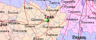
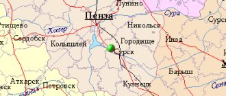
Map
| Slavgorod: maps |
Slavgorod: photo from space (Google Maps) Slavgorod: photo from space (Microsoft Virtual Earth)
| Slavgorod. Nearest cities. Distances in km. on the map (in brackets along roads) + direction. Using the hyperlink in the distance , you can get the route (information courtesy of the AutoTransInfo website) | |||
| 1 | Yarovoe | 10 (9) | SW |
| 2 | Herds | 26 (27) | YU |
| 3 | Halbstadt | 33 (30) | NE |
| 4 | Burla | 42 (48) | NW |
| 5 | Kulunda | 52 (54) | YU |
| 6 | Blagoveshchenka | 84 (132) | IN |
| 7 | Steppe Lake | 84 (142) | IN |
| 8 | Keys | 90 (95) | YU |
| 9 | Swags | 91 (120) | NE |
| 10 | Karasuk | 91 (93) | NW |
| 11 | Verkh-Suetka | 99 (111) | IN |
| 12 | Krasnozerskoe (Novosibirsk region) | 115 (182) | WITH |
| 13 | Rodino | 118 (153) | SE |
| 14 | Bagan (Novosibirsk region) | 138 (150) | NW |
a brief description of
Located in the western part of the Kulunda Plain, between lakes Sekachi and Bolshoye Yarovoye, 394 km west of Barnaul. Railway station.
8 km west of Slavgorod is the mud resort area of Bolshoye Yarovoye Lake.
Territory (sq. km): 2137
Information about the city of Slavgorod on the Russian Wikipedia site
Historical sketch
Founded in 1910 in connection with the intensification of the resettlement movement in Kulunda. The name is one of a number of artificial names with a positive meaning, characteristic of the period of mass settlement of the region.
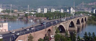
In 1914, a railway was built from Tatarsk to Slavgorod.
Since 1917 the city has been the center of Slavgorod district. In 1924, the railway was extended to Kulunda.
During the Great Patriotic War of 1941-45, industrial enterprises were evacuated to Slavgorod: a forging and pressing equipment plant from Serpukhov, a chemical plant from Perekop.
[Population data in 1959 varies greatly among different sources - check]
Economy
Production of forging and pressing equipment and sheet bending machines. PA "Altaikhimprom" Radio factory, ceramic block factory.
Meat processing plant, brewery, dairy canning plant. Sewing and furniture factories.
Slavgorod is the center of an agricultural region.
Main enterprises
RADIO INDUSTRY
OJSC "Slavgorod Radio Equipment Plant"
658840, Altai Territory, Slavgorod, st.
Titova, 167 Offers:
Amplifiers
Culture, science, education
Branch of the Altai Museum of Local Lore.
Universities of the city
Branch of Altai State University in Slavgorod
658828, Altai Territory, Slavgorod, st. Rosa Luxemburg, 75
Museums, galleries, exhibition halls
Slavgorod City Museum of Local Lore 658820, Altai Territory, Slavgorod, st. Karl Liebknechta, 143 Phone(s): (38568) 54-401
| Population by year (thousands of inhabitants) | |||||||
| 1931 | 15.9 | 1996 | 34.1 | 2008 | 34.8 | 2017 | 30.2 |
| 1939 | 21.4 | 1998 | 34.1 | 2010 | 34.8 | 2018 | 29.9 |
| 1959 | 38.4 | 2000 | 33.8 | 2011 | 32.4 | 2019 | 29.4 |
| 1967 | 31 | 2001 | 33.6 | 2012 | 32.3 | 2020 | 29.1 |
| 1970 | 32.9 | 2003 | 34.3 | 2013 | 31.7 | 2021 | 28.8 |
| 1979 | 32.1 | 2005 | 34.8 | 2014 | 31.0 | ||
| 1989 | 34.9 | 2006 | 34.8 | 2015 | 30.6 | ||
| 1992 | 35 | 2007 | 34.8 | 2016 | 30.4 | ||
Geography
The city is located between lakes Sikachi and Bolshoye Yarovoye, which is the lowest point of the Altai Territory, in the northwestern part of the Altai Territory, in the center of the Kulunda steppe, 394 km from Barnaul (by rail), 20 km from the border with Kazakhstan.
From September 1, 2011, all village councils of the disbanded Slavgorod district became part of the Slavgorod urban district
Climate
Slavgorod has a continental climate.
| Climate of Slavgorod | |||||||||||||
| Index | Jan. | Feb. | March | Apr. | May | June | July | Aug. | Sep. | Oct. | Nov. | Dec. | Year |
| Average temperature, °C | −15,4 | −15,5 | −7,8 | 4,4 | 13,0 | 19,0 | 20,9 | 18,7 | 12,5 | 3,9 | −7,6 | −12,9 | 2,8 |
| Precipitation rate, mm | 13,4 | 10,9 | 11,9 | 17,6 | 26 | 38,1 | 51,1 | 38,1 | 28,1 | 25,4 | 21,4 | 16,5 | 299,5 |
| Source: World Climate | |||||||||||||
| Climate of Slavgorod | |||||||||||||
| Index | Jan. | Feb. | March | Apr. | May | June | July | Aug. | Sep. | Oct. | Nov. | Dec. | Year |
| Absolute maximum, °C | 5,4 | 3,2 | 17,6 | 32,1 | 37,8 | 40,2 | 39,5 | 39,5 | 35,8 | 27,1 | 14,8 | 4,0 | 40,2 |
| Average maximum, °C | −13,4 | −11,8 | −4,4 | 10,1 | 20,0 | 25,3 | 26,8 | 24,3 | 18,3 | 8,4 | −3,9 | −10,5 | 7,2 |
| Average temperature, °C | −17,5 | −16,5 | −9,1 | 4,6 | 13,5 | 19,2 | 20,9 | 18,1 | 12,2 | 3,5 | −7,6 | −14,4 | 2,0 |
| Average minimum, °C | −22,3 | −21,7 | −14,5 | −1,2 | 6,2 | 12,3 | 14,7 | 11,9 | 6,2 | −1,1 | −11,8 | −19 | −3,6 |
| Absolute minimum, °C | −47,2 | −43,9 | −35 | −26,1 | −8,9 | −1,8 | 4,6 | 1,1 | −6,1 | −20 | −42,8 | −44 | −47,2 |
| Precipitation rate, mm | 20 | 16 | 15 | 18 | 26 | 44 | 53 | 38 | 22 | 29 | 24 | 20 | 325 |
| Source: Slavgorod, Russian Federation. Archive of climate data. Archived from the original on May 25, 2012. | |||||||||||||
Sport
Various sports are actively developed in Slavgorod: hockey, sambo, kickboxing, boxing, football, basketball. The youth teams of the Crystal hockey club have repeatedly taken prizes at the regional level, and in 2000 the Crystal-85 team became the champion of Russia, winning the all-Russian final tournament “Golden Puck” among hockey players born in 1985-1986, held in Yaroslavl (team coach - Anatoly Pinigin).
Sambo wrestlers from Slavgorod (coach Valery Dmitrievich Dmitriev) regularly emerge victorious in regional tournaments and zonal competitions. The guys also participate in the Russian Championship and various international tournaments. The Dolphin swimming pool has sections where schoolchildren and students conduct training. Swimmers take part in regional competitions, as well as in competitions held in other cities of Russia. The military-patriotic club “Paratrooper” was created in 1988, preparing children for military service. The Paratrooper Club has been ranked as the best military-patriotic club in the Altai Territory for 10 years in a row. City stadium "Crystal" is located in the center of Slavgorod. In addition to the football field, the stadium has a large gym and an indoor hockey stadium, which, thanks to the cooling system, functions on hot summer days.
Municipal entity Slavgorod
Population of the urban district
| Population | |||||||||
| 1959 | 1996 | 1997 | 1998 | 1999 | 2000 | 2001 | 2002 | 2003 | 2004 |
| 38 413 | ↘35 658 | ↘35 343 | ↗35 501 | ↗35 600 | ↘35 200 | ↘35 000 | ↗35 100 | ↗35 360 | ↗35 711 |
| 2005 | 2006 | 2007 | 2008 | 2009 | 2010 | 2011 | 2012 | 2013 | 2014 |
| ↗35 807 | ↘35 791 | ↘35 706 | ↘35 676 | ↘35 657 | ↘33 196 | ↗33 210 | ↗43 300 | ↘42 412 | ↘41 510 |
| 2015 | |||||||||
| ↘40 956 | |||||||||
Slavgorod urban district
| ↘30 591 | |
| Slavgorodskoe | ↘3557 |
| Breeding | ↘1214 |
| Znamenka | ↘1163 |
| Novovoznesenka | ↘932 |
| Semyonovka | ↘705 |
| Bursol | ↗654 |
| Prigorodnoye | ↗524 |
| ↘507 | |
| Arkhangelskoe | ↘282 |
| Maksimovka | ↘194 |
| Ballast Quarry | ↘140 |
| Pavlovka | ↘135 |
| Raigorod | ↘133 |
| Panovka | ↘125 |
| Andreevka | ↘87 |
| ↘79 | |
| Ekaterinivka | ↘73 |
| Vladimirovka | ↘67 |
| Kuatovka | ↘54 |
| Veseloye | ↘36 |
| Dobrovka | ↘32 |
| Aynak | →9 |
| Green Grove | →3 |
Television, print and radio broadcasting
| This section is missing references to information sources. Information must be verifiable, otherwise it may be questioned and deleted. You may edit this article to include links to authoritative sources. This mark was set on August 14, 2013 . |
A television
- 1 TVK - NTV
- 7 TVK - Channel One
- 23 TVK - TNT / TRUST-REGION
- 26 TVK - STS / TV Steppe
- 29 TVK - The first digital television multiplex
- 33 TVK - Russia 1 / State Television and Radio Broadcasting Company "Altai"
- 38 TVK - REN-TV / Channel 38 - Trust
- 47 TVK - Second digital television multiplex
- 50 TVK - Katun-24
- 56 TVK - St. Petersburg - Channel 5
Printed publications:
- "Slavgorod news"
- Newspaper "Neighbors"
Broadcasting:
- 68.20 MHz - Radio Russia / State Television and Radio Broadcasting Company Altai
- 68.60 MHz – Auto radio Slavgorod
- 102.5 MHz – Russian Radio
- 103.1 MHz - Police Wave / Katun FM
- 104.3 MHz – Radio station “Radio”
- 105.8 MHz – Auto radio Slavgorod
Social sphere
| This section is missing references to information sources. Information must be verifiable, otherwise it may be questioned and deleted. You may edit this article to include links to authoritative sources. This mark was set on August 14, 2013 . |
The social sphere is developed in Slavgorod. Health care institutions: central district hospitals (50% of departments are interdistrict), clinics, dispensaries. The education system is represented by a pedagogical college, an agricultural technical school, the Altai branch of MESI (formerly the Altai College of Informatics and Computer Science ATIVT), branches of Altai State University and Altai State Technical University, the Altai Academy of Economics and Law, and the issue of opening a branch of a pedagogical university is being decided. The city has 5 schools, 1 lyceum, 4 preschool institutions, a center for children and youth creativity and stations for young naturalists.
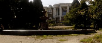
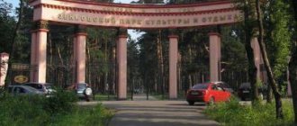
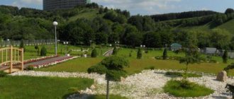
The cultural and educational network has a children's art school, a city cultural center, a local history museum, a library system, a meeting center with an exhibition hall, and a culture and recreation park.
The city has sports facilities: a swimming pool, a sports complex (stadium, hockey court, basketball court, gym), a military-patriotic club, an ice palace with artificial ice.
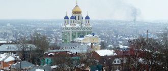
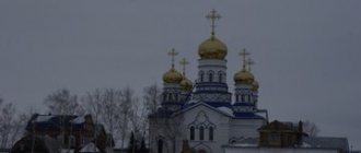
The media are represented by the newspapers “Slavgorodskie Vesti”, “Neighbors”, “Evening Slavgorod”, the weekly in German “Zeitung für Dich”, municipal television “Steppe” and private “Trust”, radio Russian Radio, Avtoradio, Police Wave In the city There are two Orthodox and Catholic churches, a mosque is being built.
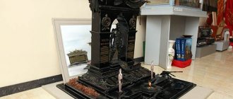
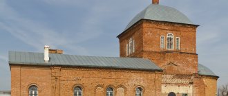
Some pre-revolutionary and pre-war buildings, in accordance with the decision of the city meeting of deputies, are classified as monuments of historical heritage. The city has a memorial of Glory to the soldiers of Slavgorod who died during the Great Patriotic War, a monument to fighters for Soviet power, an obelisk to soldiers who died in Afghanistan and Chechnya, monuments to V. I. Lenin, E. Telman and P. A. Stolypin. To mark the city's 100th anniversary, several new monuments have been unveiled in the city center and on the station square, among them a huge stone dedicated to the city's centenary and a steam locomotive.
Population
| Population | |||||||||
| 1931 | 1959 | 1967 | 1970 | 1979 | 1989 | 1992 | 1996 | 1998 | 2000 |
| 15 900 | ↗38 413 | ↘31 000 | ↗32 908 | ↘32 135 | ↗34 864 | ↗35 000 | ↘34 100 | →34 100 | ↘33 800 |
| 2001 | 2003 | 2005 | 2006 | 2007 | 2008 | 2010 | 2011 | 2012 | 2013 |
| ↘33 600 | ↗34 300 | ↗34 800 | →34 800 | →34 800 | →34 800 | ↘32 389 | ↗32 415 | ↘32 337 | ↘31 707 |
| 2014 | 2015 | ||||||||
| ↘31 006 | ↘30 591 | ||||||||
Local government
| This section is missing references to information sources. Information must be verifiable, otherwise it may be questioned and deleted. You may edit this article to include links to authoritative sources. This mark was set on August 14, 2013 . |
The representative body of government is the city meeting of deputies, consisting of 21 people. Chairman of the city meeting of deputies (head of the city) A. M. Ushanev. The head of the city administration (city manager) is appointed by the city meeting of deputies. Since July 2012, the head of the city administration is V. A. Kintzel.
Economy
The most important enterprises for the development of the city's economy are: the joint-stock company "Slavgorod Radio Equipment Plant", LLC "Slavgorod Plant KPO" (production of forging and pressing machines) and OJSC "Slavgorod Dairy Plant". A former garment factory has been converted into a municipal market. The meat processing plant is not functioning. There are a number of small enterprises producing soft drinks. The city bakery does not function; a number of private bakeries operate. About 35 percent of industrial production in the city comes from enterprises in the processing industry.
There is practically no housing construction in the city; only old ones are being renovated. In recent years, only a few buildings have been built - this is the Maria Ra shopping complex, the administrative building of the Slavgorod branch No. 0179 of Sberbank of Russia OJSC, which was put into operation on August 20, 2010, and a complex of office and residential buildings of the border department of the Federal Security Service of Russia in the Altai Territory. On May 31, 2011, the second Maria-Ra store opened, located opposite the former Old Market. And also new shopping centers were built: Stolitsa, Kremlin, Kovrov. New stores have been opened: Eldorado, Sibvez, DNS.