Geography
Kirensk is located in a floodplain bend of the Lena River at the confluence of the Kirenga River, on both banks of these rivers and on an island at their confluence, 650 km north-northeast of Irkutsk (in a straight line). The island is connected to the mainland by a dam.
The height of Kirensk above sea level is 255 m.
The left bank part of the Lena is more elevated. From the northeast, Kirensk is covered by Mount Sokolinaya, from which a picturesque view of the island city opens.
Topographic map of square O-49-B (North Baikal Highlands, Kirensk)
Transport accessibility
The nearest cities are Ust-Kut (170 km to the southwest), Severobaikalsk (250 km to the southeast).
The Lena River is the main transport route of Kirensk and the entire Kirensky district. In this section it has guaranteed depths and is navigable from the second half of May to the end of October (five months a year).
Kirensk Airport is located within the city limits, 3 km west of the city center. It can accommodate light (An-2) and medium (An-24 and -26, Yak-40) aircraft and helicopters. Provides regular flights to the regional center and a number of other settlements in the region.
During the Great Patriotic War, the airport was a key point on the air route to Yakutia and an intermediate point for ferrying aircraft from the United States (from Alaska) to the front. In those years there was no stable navigation. Special skill was required from pilots and navigators. The planes were on the road for six hours, and in winter they flew even in snowfalls, when the wings and stabilizer were covered with ice. The most difficult section of the route was on the Kirensk - Krasnoyarsk section.
The airport retains its significance as an important northern air hub today due to its convenient geographical location in the center of the northern regions of the Irkutsk region. Through the airport, aviation services are provided to the population in the northern regions of the region and aviation work is carried out to service fields in the northern part of the Irkutsk region and in Yakutia. As of 2020, flights are operated:
- regular: IK 83/84 (Irkutsk–Kirensk–Irkutsk);
- irregular: Kirensk–Nepa–Preobrazhenka–Erema–Erbogachen–Khamakar–Nakano (3 times a month); Kirensk–Tokma–Bur–Ika (3 times a month); Kirensk–Mironovo–Korshunovo–Vizirny (2-3 times a month).
Kirensk is connected by road with Ust-Kut (338 km), as well as with a number of nearby villages. But due to the poor development of the road network, motor transport does not play a significant role in the economy of this territory (unlike water transport). Only in winter does the share of freight and passenger transportation by road increase noticeably. Winter roads operate continuously from November to April.
In general, the city of Kirensk belongs to the territories of the Irkutsk region, where mass delivery of goods is carried out in a limited time frame - in the summer by water transport.
Distance from Kirenskaya to other cities by road, km
| City | Distance |
| Ust-Kut | 338 |
| Bratsk | 707 |
| Winter | 856 |
| Cheremkhovo | 863 |
| Irkutsk | 920 |
| Tulun | 932 |
| Shelekhov | 938 |
| Angarsk | 964 |
| Ust-Ilimsk | 967 |
| Bodaibo | 1040 |
| Nizhneudinsk | 1055 |
| Baykalsk | 1071 |
| Taishet | 1212 |
Kirensk
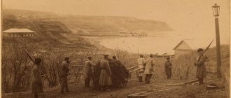
Ust-Kirensky fort
Kirensk is one of the oldest cities in what is now the Irkutsk region. It was founded in 1630 by the Cossacks of the foreman Vasily Bugr as a winter quarters at the confluence of the Lena and Kirenga rivers. In the first year, four Cossacks were left here for the winter. The following year, 1631, the winter quarters were expanded and surrounded by a wall. Thus, the settlement, originally called Nikolsky Pogost, turned into a fort, like most of the first Western Siberian settlements, which were built taking into account a possible attack by steppe nomads. However, the fort never saw battle; on the contrary, it became a center of attraction for indigenous tribes who hunted and sought to conduct profitable trade here.
The fort, called the Ust-Kirensky fort since 1665, occupied a convenient geographical location, which made it possible to control the upper reaches of the Lena River and a significant part of the Kirenga valley. The main functions of the Kirensky fort were the administrative management of the adjacent Lena lands and the collection of tribute from the local population.
The Kirensky fort received its name from the Kirenga River, at the mouth of which it was founded. According to the most common versions, the word “Kirenga” comes from the Evenki “kirenӈa” - “eagle’s nest” or from the Evenki “kiri” - “dirty”, “dirt” (the bottom of Kirenga is lined with stones, which is why it appears black (dirty) , although the water in the river is clean and transparent).
Immediately after the founding of the fort, Russian peasants began to develop lands adjacent to the fortress suitable for sowing grain. Among the first farmers here was Erofey Pavlovich Khabarov, who later became famous for his campaigns on the Amur. In addition to arable farming and gardening, shipbuilding and blacksmithing developed in the settlement. Ten years after the founding of the settlement, the first salt pan in these parts appeared here.
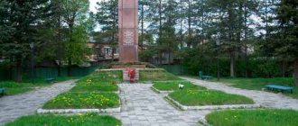
The prison was a wooden fortress with a total length of walls of 109 fathoms, with three towers, one of which was a passage tower, and loopholes were built in two corner ones. Inside the fort there was a church, a court hut, a cellar with gunpowder and lead, and three unicorns (small cannons for close and ranged combat). In the southwestern part of the fort there were shopping arcades. Now there is a park here.
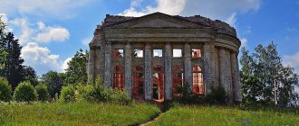
In 1663, the elder hieromonk Hermogenes scurried around in the fort of the Ust-Kirensk Hermitage. A strong monastic economy became the support of spiritual growth and enlightenment for the vast Lena lands. From the first years of its existence, the monastery exploited the population; peasants cultivated the monastery's arable land. For the use of monastic horses and equipment, as well as for the seed grain lent to the peasants by the monastery, they had to give a quarter of the harvest in return. The Ust-Kirensky Monastery played a role in the development of the territory; from the end of the 17th century, the monks of the monastery mined mica at the Mamsky mica deposit, discovered in 1689.
Significant growth of the fort occurred in the first half of the 18th century in connection with the Great Northern Expedition, led by Chirikov and Bering. Numerous cargoes of this and other expeditions were transported through the Ust-Kirensky fort to Okhotsk and further to Kamchatka. Customs and a fair operated here, along with arable farming and gardening, shipbuilding and blacksmithing developed. At this time, the future Kirensk was already a fairly populated settlement, where the Spasskaya Church stood, there was a moving-out hut, a customs house, a guest house, shops and barns, a chapel and about 40 residential buildings. In those years, the fort was the last stronghold on the way to Yakutia, Chukotka, Kamchatka and North America.
Kirensk as a city
In 1775, the Ust-Kirensk fort was given the status of a city and a new name - Ust-Kirensk. On March 13 (24), 1777, Empress Catherine II approved the coat of arms of Ust-Kirensk along with the coats of arms of other cities of the Irkutsk province. In 1785, the voivodeship office was moved from Ilimsk to Kirensk, and therefore it received the status of a county town. In 1790, a new coat of arms of the district city of Kirensk was approved along with the coats of arms of other cities of the Irkutsk governorship.
The past administrative changes contributed to new construction and growth of the city, which became not only an administrative, but also an important craft and trade center for the northern lands of the province. By the beginning of the 19th century, Kirensk already looked like a city - the city government, city hall, military command were located here, a court was established, and brisk trade was conducted. In the Ust-Kirensky Holy Trinity Monastery, back in 1783, a stone Trinity Church was built, the first stone building of the monastery.
In 1820, a new architectural plan was developed for Kirensk in St. Petersburg, according to which the main centers of the city - the main square and the monastery - remained unchanged. Some existing streets were supposed to be straightened, and a regular layout was introduced for new neighborhoods. The plan that regulated the development of the city gave Kirensk its own “urban” appearance. The shopping area on it was noted as an important part of the urban planning. Around the square there were food warehouses, salt barns, drinking houses and wine houses. The main architectural dominant was the stone Spasskaya Church, built in 1805, which was clearly visible from different parts of the city. To the south of the temple there were government buildings - the treasury, the office, the district court, and the police department. An annual fair was held in the city.
The discovery of gold deposits in the Vitim River basin in the 2nd half of the 19th century and the development of shipping in the Lena basin contributed to the further development of Kirensk. The city becomes a transshipment point for gold mining companies. About ten steamships and cargo barges stopped at a large lay-up point organized here for winter repairs. In the area of the backwater there were a steam hammer, a forge, a mechanical and foundry workshop, and a sawmill. These enterprises became the predecessors of the first production association on Lena, and ship maintenance became an important source of city income. Trade is growing, brick factories, tanneries and distilleries are being built, artisans are opening new shops.
At the beginning of the 20th century, there were already about 300 residential buildings in Kirensk, including several stone ones; the population of the city exceeded 2 thousand people. There was a ship repair shop here, as well as small shoe and tailoring factories. The population served water transport, was engaged in arable farming and gardening, and worked in gold mines and seasonal work.
Before the revolution, some shipowners and representatives of trading companies living in Kirensk were owners of millions of dollars. They bought furs and sent them to Irkutsk, supplied vegetables, potato flour, hay to the Lena mines, and traded at seasonal fairs from May to July, the turnover of which reached 50-100 thousand rubles in gold.
Several churches, the Holy Trinity Monastery and a chapel operated in Kirensk. There were city and district schools, a women's gymnasium, a parish school for boys, and a parochial school. There was a first aid station, a hospital, and a good hotel. Trade was carried out by several shops and about 30 shops. The city had a settling point for ships, a pier, and large warehouses, in particular wine warehouses.
City after 1917
After the revolution, in 1929, with the formation of the Kirensky district, Kirensk became its administrative center. In those years, Alexey Nikolaevich Kosygin, the future Chairman of the Council of Ministers of the USSR, lived and worked in the city.
The dynamic development of Kirensk continued after the Great Patriotic War, until it began in the 1980s. perestroika. The city had important transport significance and was a stronghold during the years of development of the northern territories. The development of the Alekseevskaya and Kirenskaya fleet repair and maintenance bases was under close attention. In the 1950s The gradual replacement of the old steam fleet with new, more efficient diesel vessels with increased payload capacity and improved technical performance began. Construction of new comfortable housing was underway in the city.
In the 1990s. Kirensk lost the best part of its fleet.
In mid-May 2001, the city experienced one of the worst floods in its history.
Population
Population dynamics
| 1856 | 1897 | 1926 | 1931 | 1959 | 1970 | 1979 | 1989 |
| 900 | 2300 | 4700 | 7900 | 14 412 | 14 453 | 16 154 | 16 137 |
| 1992 | 1996 | 1998 | 2001 | 2002 | 2003 | 2005 | 2006 |
| 16 500 | 16 200 | 15 600 | 15 100 | 13 712 | 13 700 | 13 100 | 12 900 |
| 2007 | 2009 | 2010 | 2011 | 2012 | 2013 | 2014 | 2015 |
| 12 800 | 12 433 | 12 640 | 12 599 | 12 359 | 12 066 | 11 802 | 11 568 |
| 2016 | 2017 | 2018 | 2019 | 2020 | |||
| 11 436 | 11 310 | 11 139 | 11 046 | 11 048 |
Climate
Kirensk has a sharply continental climate.
| Climate of Kirensk | |||||||||||||
| Index | Jan. | Feb. | March | Apr. | May | June | July | Aug. | Sep. | Oct. | Nov. | Dec. | Year |
| Absolute maximum | 1,4 | 7,0 | 16,1 | 24,4 | 32,2 | 36,8 | 36,6 | 36,5 | 29,3 | 24,0 | 8,9 | 4,1 | 36,8 |
| Average maximum, °C | −21 | −14,8 | −3,6 | 5,5 | 15,4 | 22,8 | 25,2 | 22,0 | 12,9 | 2,6 | −10,5 | −19,4 | 3,1 |
| Average temperature, °C | −26,6 | −22,3 | −12,7 | −1,4 | 7,8 | 15,3 | 18,3 | 15,1 | 6,7 | −2,1 | −15,5 | −24,5 | −3,5 |
| Average minimum, °C | −32,2 | −29,1 | −21 | −8 | 0,9 | 7,8 | 12,2 | 9,5 | 2,3 | −6 | −20,5 | −29,7 | −9,4 |
| Absolute minimum, °C | −57,8 | −56,2 | −47,7 | −36,8 | −13 | −3,8 | 0,4 | −5,3 | −10,8 | −37,6 | −49,6 | −57 | −57,8 |
| Precipitation rate | 19 | 14 | 11 | 14 | 32 | 52 | 67 | 60 | 42 | 32 | 28 | 26 | 397 |
| Source: [pogoda.ru.net/climate/30230.htm Weather and climate] | |||||||||||||
Economy
Water transport remains the city-forming basis of Kirensk. This industry is represented by OJSC Kirenskaya Fleet Electronic Warfare and a ship repair plant.
The second most important branch of Kirensk's specialization is logging. The region has significant timber resources (the estimated cutting area is one of the largest in the region - 5.3 million m3).
Other industries include the food industry, trade, and consumer services. These types of activities are mainly carried out by private entrepreneurs.
Read on Irkipedia:
- Kirensky electronic warfare of the fleet
- Kirensky district of waterways of the Federal State Institution "Lena State Basin Administration of Waterways and Shipping"
- Economic and cultural development of Kirensk in the second half of the 19th – early 20th centuries.
- Merchants, traders and entrepreneurs of the city of Kirensk
Notes
- ↑ 123
www.gks.ru/free_doc/doc_2016/bul_dr/mun_obr2016.rar Population of the Russian Federation by municipalities as of January 1, 2021 - [www.nlr.ru/e-res/law_r/search.php?regim=4&page=512&part=89 The highest approved report of the Senate, with the attachment of coats of arms of the cities of the Irkutsk governorship. // Complete collection of laws of the Russian Empire. - 1777. - Volume 20. - Law No. 14598.]
- [www.nlr.ru/e-res/law_r/search.php?regim=4&page=28&part=262 Drawing of the coat of arms of Ust-Kirensk of the Irkutsk governorship].// Complete collection of laws of the Russian Empire. - 1777. - Volume 20. - Law No. 14598. Book of drawings and drawings.
- ↑ 123456789101112
[www.MojGorod.ru/irkutsk_obl/kirensk/index.html People's encyclopedia “My City”. Kirensk]. Retrieved November 12, 2013. [www.webcitation.org/6L4UAkGEM Archived from the original on November 12, 2013]. - [demoscope.ru/weekly/ssp/rus59_reg2.php All-Union Population Census of 1959. The size of the urban population of the RSFSR, its territorial units, urban settlements and urban areas by gender] (Russian). Demoscope Weekly. Retrieved September 25, 2013. [www.webcitation.org/6GDOghWC9 Archived from the original on April 28, 2013].
- [demoscope.ru/weekly/ssp/rus70_reg2.php All-Union Population Census of 1970 The size of the urban population of the RSFSR, its territorial units, urban settlements and urban areas by gender.] (Russian). Demoscope Weekly. Retrieved September 25, 2013. [www.webcitation.org/6GDOiMstp Archived from the original on April 28, 2013].
- [demoscope.ru/weekly/ssp/rus79_reg2.php All-Union Population Census of 1979 The size of the urban population of the RSFSR, its territorial units, urban settlements and urban areas by gender.] (Russian). Demoscope Weekly. Retrieved September 25, 2013. [www.webcitation.org/6GDOjhZ5L Archived from the original on April 28, 2013].
- [demoscope.ru/weekly/ssp/rus89_reg2.php All-Union Population Census of 1989. Urban population]. [www.webcitation.org/617x0o0Pa Archived from the original on August 22, 2011].
- [www.perepis2002.ru/ct/doc/1_TOM_01_04.xls All-Russian Population Census 2002. Volume. 1, table 4. Population of Russia, federal districts, constituent entities of the Russian Federation, districts, urban settlements, rural settlements - regional centers and rural settlements with a population of 3 thousand or more]. [www.webcitation.org/65AdCU0q3 Archived from the original on February 3, 2012].
- [www.gks.ru/bgd/regl/B09_109/IssWWW.exe/Stg/d01/tabl-21-09.xls Number of permanent population of the Russian Federation by cities, urban-type settlements and districts as of January 1, 2009]. Retrieved January 2, 2014. [www.webcitation.org/6MJmu0z1u Archived from the original on January 2, 2014].
- [195.46.100.221/vpn2010/DocLib/totals-vpn2010-2.pdf Results of the 2010 All-Russian Population Census for the Irkutsk Region]. Retrieved September 23, 2013. [www.webcitation.org/6JqAskf9l Archived from the original on September 23, 2013].
- ↑ 12
[www.irkobl.ru/sites/economy/Anticorrup_ekspertiza/statistika.doc Population by municipalities as of January 1, 2012: stat. Bulletin / Irkutskstat. – Irkutsk, 2012. – 81 p.]. Retrieved September 24, 2021. [web.archive.org/web/20160306103555/irkobl.ru/sites/economy/anticorrup_ekspertiza/statistika.doc Archived from the original on September 24, 2016]. - [www.gks.ru/free_doc/doc_2013/bul_dr/mun_obr2013.rar Population of the Russian Federation by municipalities as of January 1, 2013. - M.: Federal State Statistics Service Rosstat, 2013. - 528 p. (Table 33. Population of urban districts, municipal districts, urban and rural settlements, urban settlements, rural settlements)]. Retrieved November 16, 2013. [www.webcitation.org/6LAdCWSxH Archived from the original on November 16, 2013].
- [www.gks.ru/free_doc/doc_2014/bul_dr/mun_obr2014.rar Table 33. Population of the Russian Federation by municipalities as of January 1, 2014]. Retrieved August 2, 2014. [www.webcitation.org/6RWqP50QK Archived from the original on August 2, 2014].
- [www.gks.ru/free_doc/doc_2015/bul_dr/mun_obr2015.rar Population of the Russian Federation by municipalities as of January 1, 2015]. Retrieved August 6, 2015. [www.webcitation.org/6aaNzOlFO Archived from the original on August 6, 2015].
- taking into account the cities of Crimea
- [www.gks.ru/free_doc/doc_2016/bul_dr/mun_obr2016.rar Population of the Russian Federation by municipalities as of January 1, 2021. Table “31. Population of cities and towns by federal districts and constituent entities of the Russian Federation as of January 1, 2021.” RAR archive (1.0 MB)]
- lenaturflot.ru/en/peleduy-ust-kut-peleduy-raspisanie/ Schedule of high-speed passenger ships on the Peleduy – Kirensk line
Natives and residents
- Valeryan Mikhailovich Golitsyn - Decembrist, participant in the Russian-Turkish War of 1828-1829, the Caucasian War of 1817-1864.
- Maxim Lukich Galat - revolutionary.
- Fedor Grigorievich Uglov is a Russian surgeon, academician of the Russian Academy of Medical Sciences.
- Alexey Nikolaevich Kosygin is a Soviet statesman and party leader, head of the USSR Government.
- Afanasy Nikitich Antipin - WWII participant, writer, Honored Teacher of the RSFSR, Director of the Institute for Advanced Training of Teachers of the Irkutsk Region.
- Leonid Nikolaevich Kulagin is a Soviet and Russian actor, film director, screenwriter, People's Artist of the RSFSR.
- Evgeniy Vasilyevich Talalaev - Doctor of Biological Sciences, professor, one of the country's leading microbiologists, head of the Department of Plant Physiology and Microbiology at Irkutsk State University.