City `s history
The city was founded on the site of large deposits of thermal coal discovered at the beginning of the last century in the territory of the current Inta region.
Since 1940, industrial development of the Inta coal deposit, which is part of the Pechora coal basin, began. On November 25, 1942, the settlement of Inta, Kosyavomsky village council, Kozhvinsky district, was transformed into an urban-type settlement. For the first four years, Intastroy was engaged in the exploration of new coal deposits, the construction of mines, and also created an energy and mechanical repair base. Initially, the mines and the railway were built by prisoners of the Gulag camps (Inta and Mineral ITL). The Mineralny ITL housed up to 34.5 thousand prisoners at a time. Coal mining began in 1943, and soon a train with coal from Inta was the first to be sent to besieged Leningrad.
On January 1, 1954, the Inta district with its center in the village of Verkhnyaya Inta was withdrawn from the Kozhvinsky district, and on October 4, 1954 it received the status of a city.
The collapse of the USSR led to a sharp reduction in coal production, Inta's economy fell into decay, and only one of the six mines remained - Intinskaya. This led to job losses and a massive exodus of residents from the city.
More detailed information on history in our library.
About the city Inta
Inta is a city (founded in 1942, city status was assigned in 1954). Located in the northeast of the Komi Republic. The population of the city is 33,861 people. Together with adjacent settlements, it forms a municipal entity - the urban district of the city of Inta, with a population of 36,436 people.
Foundation of the city
The city was founded on the site of large deposits of thermal coal discovered at the beginning of the last century in the territory of the current Inta region. Since 1940, industrial development of the Inta coal deposit, which is part of the Pechora coal basin, began.
On November 25, 1942, the settlement of Inta, Kosyavomsky village council, Kozhvinsky district, was transformed into an urban-type settlement. For the first four years, Intastroy was engaged in the exploration of new coal deposits, the construction of mines, and also created an energy and mechanical repair base. Initially, the mines and the railway were built by prisoners of the Gulag camps (Inta and Mineral ITL). The Mineralny ITL housed up to 34.5 thousand prisoners at a time. Coal mining began in 1943, and soon a train with coal from Inta was the first to be sent to besieged Leningrad.
On January 1, 1954, the Inta district with its center in the village of Verkhnyaya Inta was withdrawn from the Kozhvinsky district, and on October 4, 1954 received the status of a city.
Modern period
The collapse of the USSR led to a sharp reduction in coal production, Inta's economy fell into decay, and only one of the six mines remained - Intinskaya. This led to job losses and a massive exodus of residents from the city.
Geographical position
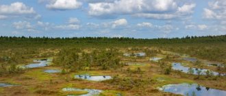
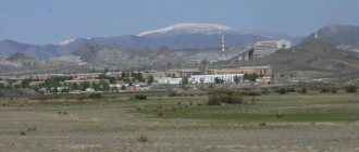
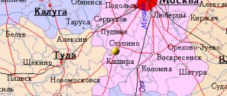
The city is located in the forest-tundra west of the Ural Mountains, in the northeast of the Komi Republic, on the left bank of the Bolshaya Inta River. The distance to Syktyvkar is 608 km, to Moscow – 1600 km. Geographic coordinates: 66°02′ N. w. 60°08′ E. d. (G) (O).
Inta is located in the Moscow time zone. The offset relative to UTC is +4:00.
Climate
The city of Inta belongs to the regions of the Far North.
Inta is located in a continental climate region. It is characterized by long, harsh winters with stable snow cover and cool, humid summers with a small number of cloudless and hot days.
Average annual air temperature - −3.9 °C
Relative air humidity - 77.2%
Average wind speed - 3.7 m/s
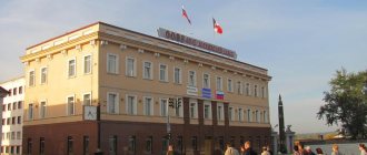
Authorities
The post of head of the city administration in 2003-2006 was held by Vladimir Shakhtin, who was suspended from activities for failure to comply with a court decision to transfer residential buildings in the village of Verkhnyaya Inta to the balance of the city. Currently, the post of head of the city district is occupied by Pavel Smirnov. The positions of deputy heads are occupied by Andrey Borodin and Larisa Titovets, and the position of first deputy is occupied by Evgeny Polyakov.
The representative body of city government is the city council. Consists of 25 deputies elected by the city population in a referendum for a period of 4 years. Chairman of the Council - Vasily Smaliy.
Administrative structure
The city of Inta includes several microdistricts:
Central, Western, Eastern, Zarechny (Agricultural), Southern, Shakhtarsky.
Architecture
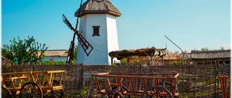
The historical part of Inta, the so-called “Old Town”, was built in the middle of the 20th century and consisted of two-story wooden houses. Later, in the 1960s, the construction of standard multi-story brick houses began.
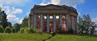
In 1955, the construction of the water tower, the main attraction of Inta, depicted on the coat of arms, was completed. The construction of the structure took place from 1953 to 1955. The architect of the tower was the Swedish political prisoner Arthur Tamvelius, who considered the design of the building “dull.” Currently, the water tower is decommissioned and is in dilapidated condition. By 2014, it is planned to completely restore the tower and open a museum in it.
Industry
The main type of industry is coal mining. The city is home to the Intaugol coal mining enterprise, which has been at the bankruptcy stage since August 9, 2007. owns the last coal mine, Intinskaya, located in the Yuzhny microdistrict, as well as a number of other enterprises, including Avtobaza JSC and State Farm Bolshaya Inta JSC. As of 2010, 1,640 people work in the mining industry, which is about 4% of the total urban population.
There is also a bakery, a poultry farm and a dairy plant in the city. Not far from Inta there are large deposits of manganese ore (Parnok iron-manganese deposit).
Education
There are 15 kindergartens directly in the city, four more in other settlements of the district: on Yustydor, in the village of Verkhnyaya Inta and in the villages of Abez and Petrun. There are 14 secondary educational institutions in the district, including two gymnasiums and one lyceum. In addition, in the village of Adzvavom there is the “Elementary school-kindergarten of the village of Adzvavom”.
Secondary specialized and secondary vocational education is represented by a branch of the Vorkuta Mining and Economic College and the Inta Polytechnic College.
There are additional education centers in the city: “Center for Extracurricular Activities”, “Center for Students”, “Station of Young Naturalists”, “School of Arts” and others.
Sport
Inta has the Yunost Sports Palace, a stadium, a children's swimming pool "Dolphin", a station for young tourists and a sports and recreation complex "Zapadny", which includes gyms, a ski track, a swimming pool, a stadium and a hockey court. From time to time, the city hosts ice speedway competitions.
Honored Master of Sports of the USSR, hockey player Viktor Zhluktov, as well as Honored Master of Sports of the Republic of Belarus, hockey player Vladimir Tsyplakov, were born and raised in Inta.
Famous townspeople
Gaizer Vyacheslav Mikhailovich (born December 28, 1966) is a Russian statesman, 3rd Head of the Komi Republic. Pay attention - he is behind bars!!!
Zhluktov Viktor Vasilyevich (born January 29, 1954) Soviet hockey player, Honored Master of Sports of the USSR.
Istikhovskaya Marina Dmitrievna (born November 26, 1965) - Chairman of the State Council of the Komi Republic. Also Gaiser's man!!!
Kuibida Vasily Stepanovich (born May 8, 1958) is a Ukrainian politician, Minister of Regional Development and Construction of Ukraine.
Andrey Vyacheslavovich Lopatov (born March 12, 1957) is a basketball player, bronze medalist at the 1980 Summer Olympics in Moscow, Honored Master of Sports of the USSR.
Urbansky Evgeniy Yakovlevich (born February 27, 1932 in Moscow; died November 1, 1965) - Soviet theater and film actor, Honored Artist of the RSFSR.
Tsyplakov Vladimir Viktorovich (born April 18, 1969) is a Soviet and Belarusian hockey player, Honored Master of Sports of the Republic of Belarus.
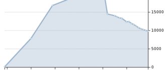
Population
- 1959 – 45,136 people
- 1966 – 49,800 people
- 1970 – 50,178 people
- 1979 – 50,862 people
- 1989 – 60,220 people
- 2002 – 41,217 people
- 2009 – 33,442 people
- 2010 – 32,080 people
- 2012 – 30,524 people
- 2013 – 29,404 people
Climate of Inta
Inta is located in a continental climate region. It is characterized by long, harsh winters with stable snow cover and cool, humid summers with a small number of cloudless and hot days.
Average annual air temperature - −3.9 °C Relative air humidity - 77.2% Average wind speed - 3.7 m/s
| Climate of Inta | |||||||||||||
| Index | Jan | Feb | Mar | Apr | May | Jun | Jul | Aug | Sep | Oct | But I | Dec | Year |
| Average temperature, °C | −25,5 | −30,1 | −10,9 | −6,8 | 0,7 | 9,6 | 14,2 | 10,2 | 4,3 | −3,3 | −12,9 | −16,9 | −3,9 |
Streets of the municipality
On the map of Inta with streets it is noted that the city consists of nine microdistricts:
- Zarechny (Selkhozny);
- Gorny;
- Transport;
- Sports;
- Southern;
- Shakhtarsky;
- Central;
- Eastern;
- Western.
There are 128 streets in the city. The main ones are:
- Kirov;
- Industrial;
- Kuratova;
- Depovskaya;
- Gorky;
- Eastern;
- Martovskaya;
- Industrial;
- Western.
There are Lenin and Komsomolskaya squares. Most of the administrative buildings and infrastructure of the municipality are located on these streets and squares. The detailed map of Inta says that the Naryan-Mar - Ukhta highway passes through the city. There is a train connection, and an airport serving domestic flights is 2 kilometers away.
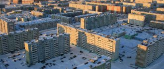
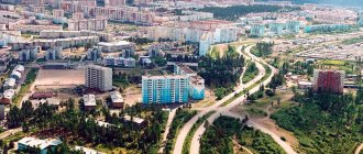
The map of Inta with houses shows that the city has a historical part. These are two-story wooden buildings built over 70 years ago. There are "Stalinists". Further from the center there are microdistricts where buildings erected in the late sixties and nineties of the last century are located. These are typical five and nine-story buildings. There are also several modern buildings. The Inta map with house numbers says that some part of the city is occupied by the private sector. The city's housing stock is served by 18 management companies.
Population
According to the Federal State Statistics Service, as of January 1, 2010, 36,436 people live in the urban district of Inta, of which 2,575 live in rural areas, which is about 4% of the population of the Komi Republic. From January to March 2010, the average number of employees of organizations is 10,073 people, of which 1,640 are employed in the field of mineral extraction, in particular coal. As of May 2010, the unemployment rate is 3.9%.
| Year | 1959 | 1966 | 1970 | 1979 | 1989 | 2002 | 2009 | 2010 | 2011 |
| Number of people, people | 45 136 | 49 800 | 50 178 | 50 862 | 60 220 | 41 217 | 33 442 | 33 861 | 34 221 |
Industry and economics of the municipality
The key type of industry for Inta is coal mining. Deposit development is carried out in the following mines:
- Eastern;
- Deep;
- Intinskaya;
- Capital;
- Western.
The Inta map with a diagram shows that there are other large enterprises in the city. For example, “Sevpromugol”, “Kazhim Exploration and Production Enterprise”, “Inta Concentration Plant”. There are factories for the production of milk, poultry, and bread baking. There are more than 30 large and small retail outlets. For example, stores “Vodopad”, “North”, “June”.
- They have their own printed publications, television, and radio.
- There are 12 kindergartens, a lyceum, 15 schools, and a gymnasium.
- There is an art school, but also other educational institutions.
- There is a sports palace, a swimming pool, gyms, fitness clubs and other sports organizations.
- There are bank branches and a post office.
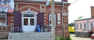
- There is a museum, libraries, cultural centers.
There is practically no new housing construction in Inta. Mostly low-rise private sector buildings are being built. Currently, the housing stock includes over 245 apartment buildings, the total area of which exceeds 850 thousand square meters. A number of buildings are recognized as unsafe and are subject to resettlement. It is expected that new and comfortable housing will be built in their place.
Authorities
The post of head of the city administration in 2003-2006 was held by Vladimir Shakhtin, who was suspended from activities for failure to comply with a court decision to transfer residential buildings in the village of Verkhnyaya Inta to the balance of the city. Currently, the post of head of the city district is occupied by Pavel Smirnov. The positions of deputy heads are occupied by Andrey Borodin and Larisa Titovets, and the position of first deputy is held by Mikhail Boretsky.
The representative body of city government is the city council. Consists of 25 deputies elected by the city population in a referendum for a period of 4 years. Chairman of the Council - Vasily Smaliy.
Administrative-territorial structure
The administrative-territorial structure, status and boundaries of the city of republican significance Inta with its subordinate territory are established by the Law of the Komi Republic of March 6, 2006 No. 13-RZ “On the administrative-territorial structure of the Komi Republic”[21]. The administrative-territorial formation includes 7 administrative territories:
| № | Administrative territory | Administrative center | Settlements | Number of settlements |
| 1 | city of republican significance Inta with adjacent territory | Inta city | Inta town, Yustydor settlement | 2 |
| 2 | urban-type settlement Verkhnyaya Inta with its subordinate territory | Verkhnyaya Inta village | Verkhnyaya Inta village, Kochmes village | 2 |
| 3 | urban-type settlement Kozhym with its subordinate territory | Kozhym village | Kozhym village, Komayu village, Lazurny village, Kozhymvom village | 4 |
| 4 | rural-type settlement Abez with its subordinate territory | pst Abez | pst Abez, pst Usa, pst Fion, village Abez, village Epa, village Toshpi, village Yarpiyag | 7 |
| 5 | the village of Adzvavom with the territory subordinate to it | With. Adzvav | With. Adzvavom, village of Adzva | 2 |
| 6 | the village of Kosyuvom with the territory subordinate to it | With. Kosyuvom | With. Kosyuvom, pst Kochmes, village Yagyol | 3 |
| 7 | the village of Petrun with its subordinate territory | With. Petrun | With. Petrun, pst Kostyuk, Rogovaya village | 3 |
Compound
The administrative-territorial entity and urban district includes 23 settlements:[21]
| № | Locality | Type of settlement | Population |
| 1 | Abez | village | ↘117[10] |
| 2 | Abez | village | ↘478[10] |
| 3 | Adzva | village | ↘0[10] |
| 4 | Adzvav | village | 98[10] |
| 5 | Verkhnyaya Inta | town | ↘1048[22] |
| 6 | Epa | village | 32[10] |
| 7 | Inta | city, administrative center | ↘23 701[22] |
| 8 | Kozhim | town | ↘3[22] |
| 9 | Kozhymvo | village | 1[10] |
| 10 | I like | village | ↘0[10] |
| 11 | Kostyuk | village | ↘3[10] |
| 12 | Kosyuvom | village | 176[10] |
| 13 | Kochmes | village | ↘0[10] |
| 14 | Kochmes | village | ↘46[10] |
| 15 | Azure | village | ↘16[10] |
| 16 | Petrun | village | 439[10] |
| 17 | Horny | village | 69[10] |
| 18 | Toshpi | village | 3[10] |
| 19 | Usa | village | 6[10] |
| 20 | Ffion | village | 1[10] |
| 21 | Yustydor | village | 388[10] |
| 22 | Yagyol | village | 25[10] |
| 23 | Yarpiyag | village | 87[10] |