“The city is great and full of people” - this is how the Ustyuzhan Chronicle of the 9th century describes the glorious ancient Smolensk. This is the very first mention of the glorious Smolensk region. For the second millennium, an ancient Russian city has been standing on the banks of the Dnieper, which has become a major regional center. Traveling through these places becomes a real discovery of the glorious region. Not only the nature and architecture are surprising, but also the population of the Smolensk region. Guests here are always greeted warmly, with Russian grandeur.
Location of the Smolensk region
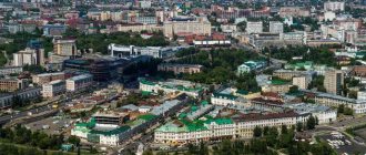
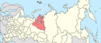
The western borders of the Russian land are framed by the glorious Smolensk lands, which can be compared to a wise old warrior guarding peace. And, indeed, more than once this heroic city became a shield for Russia. Smolensk itself is located in the upper reaches of the Dnieper River at a distance of 365 km from Moscow. The Smolensk region is a subject of the Russian Federation and is part of the Central Federal District.
The city, which originated on seven hills, along which the trade route from the “Varyags to the Greeks” passed, became the center of many settlements. Today, the Smolensk region has a common border with the Bryansk, Pskov, Moscow, Kaluga, and Tver regions. Belarus adjoins the Smolensk region with the Vitebsk and Mogilev regions. The region was formed in 1937.
Map
| Smolensk: maps |
Smolensk: photo from space (Google Maps) Smolensk: photo from space (Microsoft Virtual Earth)
| Smolensk Nearest cities. Distances in km. on the map (in brackets along roads) + direction. Using the hyperlink in the distance , you can get the route (information courtesy of the AutoTransInfo website) | |||
| 1 | Kardymovo | 27 (28) | NE |
| 2 | Red | 46 (55) | SW |
| 3 | Pochinok | 49 (52) | SE |
| 4 | Monasticism | 50 (56) | YU |
| 5 | Spirituality | 51 (55) | NE |
| 6 | Yartsevo | 51 (56) | NE |
| 7 | Glinka | 55 (94) | IN |
| 8 | Demidov | 63 (92) | NW |
| 9 | Rudnya | 65 (68) | Z |
| 10 | Khislavichi | 67 (82) | YU |
| 11 | Yelnya | 76 (106) | IN |
| 12 | Dorogobuzh | 81 (124) | IN |
| 13 | Safonovo | 84 (97) | NE |
| 14 | Verkhnedneprovsky | 86 (117) | IN |
| 15 | Ozerny | 91 (101) | WITH |
| 16 | Velizh | 105 (128) | NW |
| 17 | Shumyachi | 105 (132) | YU |
| 18 | Roslavl | 106 (109) | SE |
| 19 | Desnogorsk | 106 (144) | SE |
| 20 | Zharkovsky (Tver region) | 119 (328) | WITH |
a brief description of
Hero city. Located in the upper reaches of the river. Dnieper (pier), between the Dukhovshchinskaya and Krasninsko-Smolenskaya uplands, 419 km west of Moscow. Railway junction lines and highways.
In 1949, Smolensk was included in the list of 20 historical cities of the USSR. The urban planning value of its heritage is assessed as world class.
The climate is moderate continental. Winter is moderately mild, the average temperature in January is -9. Summer is moderately warm, the average temperature in July is +18. Precipitation is 600 mm per year, maximum in July.
Territory (sq. km): 166
Information about the city of Smolensk on the Russian Wikipedia site
Historical sketch
It was first mentioned in the Ustyug (Arkhangelogorod) chronicle code under 862-65. It was the center of the Slavic Krivichi tribe, a large trade and craft settlement on the ancient trade route “from the Varangians to the Greeks,” and a military fortress.
Since 882 as part of Kievan Rus, from the 12th century. center of the Smolensk Principality.
Smolensk was a major center at the beginning of the 13th century. came out on top among the architectural and construction centers of Rus'. The terrible epidemic of 1230 and then the Mongol-Tatar invasion interrupted construction in the city.
In 1404-1514. was part of the Grand Duchy of Lithuania, then - in the Moscow State.
In the chronicles under the dates of the 9th-13th centuries. the name is given in the forms Smolensk, Smolinesk, Smolnesk - the stem Smol(n)- and the suffix -esk, typical of the names of ancient Russian cities, are obvious. The etymology is convincing, according to which the city was named after its location on the river. Smolnya; hydronym from Slavic smol - “black soil”. But also of interest is what was said back in the 19th century. the idea of the origin of the name of the city from the Slavic ethnonym Smolyan / Smolene.
After construction in 1596-1602. stone fortress wall (under the leadership of the architect Fyodor Kon), Smolensk became the most important Russian fortress on the western border. After the Smolensk defense of 1609-11. captured by Poland, taken by Russian troops in 1654, returned to Russia by the Truce of Andrusovo in 1667.
In 1708-13 center of the Smolensk province. Since 1713 in the Riga province, since 1719 - the center of the Smolensk province. In 1726-75. the center of the newly formed Smolensk province, from 1775 - the Smolensk governorship (from 1796 - the Smolensk province).
During the Patriotic War of 1812, the armies of M.B. united in the Smolensk region. Barclay de Tolly and P.B. Bagration. On August 4-6 (16-18) the Battle of Smolensk took place. As a result of fierce battles, the Russian command withdrew troops to the Old Smolensk Road, which made it possible to avoid a general battle and the defeat of the Russian army in unfavorable conditions. November 4 (16), 1812 Smolensk was liberated.
In 1856, in the provincial city of Smolensk, Smolensk province, there were 37 churches, 2185 houses, 177 shops. Data on the city's population in 1856 may contain an error in the source.
In the second half of the 19th century. The Riga-Oryol (1868), Moscow-Brest (1870) and Ryazan-Ural (1899) railways passed through Smolensk, contributing to the economic development of the city.
Since 1929, Smolensk has been the center of the Western Region. Since 1937 - Smolensk region.
During the Great Patriotic War of 1941-45, the Smolensk Battle of 1941 took place in the city area, which delayed the advance of Nazi troops on Moscow for 3 months. The city was occupied since July 16, 1941. It was liberated on September 25, 1943 by troops of the Western Front during the Smolensk-Roslavl operation.
During the war years in Smolensk, all industrial enterprises were destroyed and 93% of the housing stock was destroyed. The city was rebuilt in the post-war period.
In 1979, the villages of Kolodnya (urban settlement since 1937, 12.5 thousand inhabitants, 1939; 12.8 thousand inhabitants, 1959; 14.7 thousand inhabitants, 1970; 14.7 thousand inhabitants, 1979) and Gnezdovo (5.1 thousand inhabitants, 1970; 8.1 thousand inhabitants, 1979).
Municipal indicators
| Index | 1990 | 1999 | 2001 | 2003 | 2005 |
| Demography | |||||
| Number of births, per 1000 population | 11.3 | 6.4 | 7.5 | 8.8 | 8.5 |
| Number of deaths, per 1000 population | 9.3 | 14.1 | 15.1 | 17.5 | 17.3 |
| Natural increase (decrease), per 1000 population | 2 | -7.7 | -7.6 | -8.7 | -8.8 |
| Standard of living of the population and social sphere | |||||
| Average monthly nominal accrued wages, rub. | 0.269 | 1399 | 3180 | 5355 | 7679 |
| Average housing area per inhabitant (at the end of the year), sq.m. | 14.1 | 18.1 | 18.7 | 21 | 22.4 |
| Number of preschool institutions, pcs. | 134 | 89 | 88 | 82 | 80 |
| Number of children in preschool institutions, thousand people | 20.1 | 10.7 | 10.6 | 10.5 | 10.8 |
| Enrollment of children in preschool educational institutions (at the end of the year), as a percentage of the number of children of the corresponding age, % | 78.3 | 75 | |||
| Number of daytime educational institutions (at the beginning of the school year), pcs. | 45 | 50 | 50 | 50 | 49 |
| Number of students in daytime educational institutions, thousand people | 40.1 | 43 | 39.4 | 35.4 | 30.2 |
| Number of doctors, people. | 3870 | 3921 | 3936 | 4108 | 3820 |
| Number of nursing staff, people. | 6855 | 5164 | 4425 | 4411 | 4433 |
| Number of hospital institutions, pcs. | 17 | 17 | 17 | 17 | 17 |
| Number of hospital beds, thousand units | 6.5 | 5.2 | 5.1 | 4.8 | 4.6 |
| Number of medical outpatient clinics, pcs. | 41 | 71 | 81 | 85 | 87 |
| Capacity of medical outpatient clinics, visits per shift, thousand units. | 5.9 | 8.6 | 8.8 | 8.7 | 8.9 |
| Number of registered crimes, pcs. | 4199 | 7523 | 6710 | 7603 | 11119 |
| Persons who committed crimes were identified, persons. | 2745 | 3199 | 2674 | 1809 | 2006 |
| Economy, industry | |||||
| Number of enterprises and organizations (at the end of the year), pcs. | 11232 | 13772 | 30205 | 20879 | |
| Number of operating enterprises by type of activity: mining (at the end of the year), pcs. | 2 | ||||
| Number of operating enterprises by type of activity: manufacturing (at the end of the year), pcs. | 230 | ||||
| Number of operating enterprises by type of activity production and distribution of electricity, gas and water (at the end of the year), pcs. | 61 | ||||
| Volume of shipped goods of own production by type of mining (in actual prices), million rubles. | 15.5 | ||||
| Volume of shipped goods of own production by type of manufacturing (in actual prices), million rubles. | 23782.2 | ||||
| Volume of shipped goods of own production by type of production and distribution of electricity, gas and water (in actual current prices), million rubles. | 11082.8 | ||||
| Construction | |||||
| Volume of work performed by type of activity “Construction” (until 2004 - volume of work performed under construction contracts), million rubles. | 0.164 | 726.7 | 1239.8 | 1709.4 | 2737.5 |
| Commissioning of residential buildings, thousand sq.m. of total area | 152.4 | 81 | 100.9 | 169 | 175.6 |
| Commissioning of residential buildings, apartments | 1101 | 1295 | 2199 | 2764 | |
| Commissioning of preschool institutions, places | 70 | 0 | 0 | 0 | 0 |
| Commissioning of educational institutions, places | 1296 | 0 | 0 | 0 | 0 |
| Commissioning of hospital facilities, beds | 0 | 0 | 0 | 0 | 0 |
| Commissioning of outpatient clinics, visits per shift | 1150 | 500 | 0 | 0 | 0 |
| Transport | |||||
| Number of bus routes (in intracity traffic), pcs. | 34 | 30 | 29 | 29 | 32 |
| Number of tram routes, pcs. | 10 | 7 | 5 | 5 | 5 |
| Length of operational tram tracks (at the end of the year), km | 24.6 | 24.8 | 24.8 | ||
| Number of trolleybus routes, pcs. | 2 | 2 | 2 | 2 | |
| Length of operational trolleybus lines (at the end of the year), km | 0 | 13.3 | 13.3 | ||
| Number of passengers transported by buses per year (in intracity traffic), million people. | 62.5 | 26 | 26.8 | 81.6 | 43.8 |
| Number of passengers transported by trams per year, million people. | 69 | 74.8 | 75.7 | 127.6 | 58 |
| Number of passengers transported by trolleybuses per year, million people. | 0 | 21.7 | 20.4 | 39 | 19.8 |
| Connection | |||||
| Number of telephone sets of the city public telephone network, thousand units. | 58.5 | 87.6 | 100.4 | 110.5 | 122.5 |
| Number of residential telephone sets of the city public telephone network, thousand units. | 37.3 | 65.9 | 80.5 | 88.8 | 97 |
| Number of payphones of the city telephone network (including universal ones), pcs. | 1293 | 996 | |||
| Trade and services to the population | |||||
| Retail trade turnover (in actual prices), million rubles. | 4783.4 | 8392.7 | 12577.9 | 21953 | |
| Retail trade turnover (in actual prices), per capita, rub. | 13493 | 24055 | 38941 | 68900 | |
| Index of physical volume of retail trade turnover, % compared to the previous year | 102 | 120 | |||
| Index of physical volume of public catering turnover, % compared to the previous year | 86.1 | 95 | |||
| Number of stores, pavilions (at the end of the year), pcs. | 204 | 175 | |||
| Sales area of shops, pavilions (at the end of the year), sq.m. | 26286.2 | 33481 | |||
| Volume of paid services to the population (in actual prices), million rubles. | 0.09 | 1076.1 | 1981.6 | 3946.4 | 6465.9 |
| Volume of paid services to the population (in actual prices), per capita, rub. | 0.3 | 3036 | 5679 | 12218 | 20293 |
| Volume of household services to the population (in actual prices), million rubles. | 0.031 | 170.8 | 189.3 | 222.5 | 328.1 |
| Volume of household services to the population (in actual prices), per capita, rub. | 0.09 | 482 | 543 | 689 | 1030 |
| Investments | |||||
| Investments in fixed assets (in actual prices), million rubles. | 0.17 | 517.7 | 1209 | 2487 | 2831.8 |
| Share of investments in fixed assets financed from budgetary funds in the total volume of investments, % | 87 | 11 | 15 | 3 | 9 |
Data sources:
- Regions of Russia. Main characteristics of the constituent entities of the Russian Federation: statistical collection. Goskomstat of Russia. - M:, 2003.
- Regions of Russia. Basic socio-economic indicators of cities. Statistical collection. Rosstat. - M:, 2005. p. 74
- Transport in Russia: Statistical collection. Goskomstat. - M:, 2003. pp. 110, 112, 120, 122
- Transport in Russia: Statistical collection. Rosstat. - M:, 2005. pp. 117, 119, 127, 129
- Regions of Russia. Basic socio-economic indicators of cities. 2006. Statistical collection. Rosstat. - M:, 2006. p. 74
Culture, science, education
Institutes: medical, pedagogical, agricultural, physical education.
Theatres: drama, puppet theaters.
Museums: Smolensk Historical and Architectural and Artistic Museum, sculptures named after S.T. Konenkov, Patriotic War of 1812.
Architecture, sights
The Dnieper divides Smolensk into northern and southern parts. The central part of the city is located on hills separated by long deep ravines, behind it are modern residential areas.
The historical center of Smolensk is surrounded by powerful fortress walls with towers (1596-1600). The length of the walls is about 6.5 km, the height is about 10-12 m, the thickness is about 5 m, there were 38 towers (17 have survived).
The ensemble of Cathedral Mountain includes the Assumption (1677-1740) and Epiphany (1787) cathedrals, St. John the Baptist Church (1703-80; being restored), the bishop's house (1770), etc.
Also preserved are the churches of Peter and Paul on Gorodyanka (1146), Michael the Archangel (Svirskaya, 1194), St. John the Evangelist (1160, rebuilt in the 18th century), St. George's (1782), Resurrection (1765), Transfiguration of the Savior (1766).
Ensemble of the Trinity Monastery with the cathedral (1738-40). Spaso-Preobrazhensky Cathedral of the Avraamievsky Monastery (1755), the Church of the Ascension (1700) and Akhtyrskaya (1830) of the Ascension Monastery.
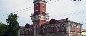
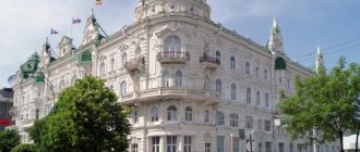
The buildings of the former governor's house (1781) and the Assembly of the Nobility (1825).
18 km north of Smolensk is the village of Talashkino, the former estate of Princess M.K. Tenisheva, who organized decorative ceramics and wood carving workshops here. In the estate there is a wooden house “Teremok” (1901, architect S.V. Malyutin), Spasskaya Church-tomb (1902, architect V.V. Suslov with the participation of N.K. Roerich), Church of the Holy Spirit (1902-03 ).
| Population by year (thousands of inhabitants) | |||||||
| 1811 | 12.4 | 1956 | 131 | 1996 | 355.7 | 2013 | 331.0 |
| 1840 | 11.0 | 1959 | 147.2 | 1998 | 355.9 | 2014 | 331.0 |
| 1856 | 9.2 | 1962 | 164 | 2000 | 353.4 | 2015 | 330.0 |
| 1863 | 23.1 | 1967 | 196 | 2001 | 350.6 | 2016 | 328.9 |
| 1897 | 47.0 | 1970 | 210.8 | 2003 | 325.1 | 2017 | 329.9 |
| 1913 | 73.1 | 1973 | 234 | 2005 | 319.3 | 2018 | 330.0 |
| 1914 | 74.1 | 1976 | 279 | 2006 | 317.9 | 2019 | 329.4 |
| 1923 | 63.7 | 1979 | 276.4 | 2007 | 317.7 | 2020 | 325.5 |
| 1926 | 71.0 | 1982 | 316 | 2008 | 316.5 | 2021 | 320.2 |
| 1931 | 86.5 | 1986 | 334 | 2010 | 314.5 | ||
| 1934 | 110.0 | 1989 | 341.5 | 2011 | 326.9 | ||
| 1939 | 156.9 | 1992 | 351.6 | 2012 | 329.9 | ||
Literature
- Krogius V.R.
Historical cities of Russia as a phenomenon of its cultural heritage. M.: Progress-Tradition, 2009. pp. 186-188 - Pospelov E.M.
Geographical names of the world: Toponymic dictionary: About 5000 units. M.: Russian dictionaries, Astrel Publishing House LLC, AST Publishing House LLC, 2001. p. 388 - Ch.
ed. Gorkin A.P. Geography of Russia: encyclopedic dictionary. M.: Great Russian Encyclopedia, 1998. pp. 541-542 - Ch.
ed. Lappo G.M. Cities of Russia: encyclopedia. M.: Great Russian Encyclopedia, 1994. pp. 425-428
Brief description of the area
The Smolensk region occupies about 50,000 km in the center of the East European Plain. There are both highlands and lowlands here. The climate here is moderate continental, as the climate zone is temperate. Driving through this area, you can observe wavy surfaces, hilly areas, and river valleys.
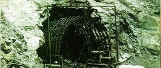
On the territory of the Smolensk region there are many minerals of sedimentary origin. Here you can encounter deposits of brown coal, peat, rock salt, loam, and clay. Nature has not deprived these lands of healing mud and mineral waters. Sometimes there are deposits of rock crystal, silicon, ore, and ocher. Peat reserves in this area are very large. Sand, gravel, and gypsum are mined here for construction work.
In winter the temperature here is moderately frosty, in summer it is warm and rainy. Such tributaries of the Dnieper as the Vyazma, Vop, Desna, and Sozh flow through the region. From here such large rivers as the Volga and Oka, into which the Vazuza and Ugra flow, also replenish their water reserves.
The main area of the Smolensk region is occupied by sod-podzolic soils. Sometimes there are sandy and loamy areas. There are many forests, meadows, and swamps in this region. Cultivated plants are widely planted. The main representatives of forests are spruce, birch, and aspen. Oaks, maples, ash trees, and linden trees are slightly less represented. The fauna here is represented by many species of mammals and birds. About 50 species of fish are found in local reservoirs.
Historical information
Initially, the Krivichi lived on the lands of the Smolensk region; the population of the Smolensk region originates from them. Then the city was under the control of Kievan Rus for a long time. The heyday of the Smolensk Principality occurred in the 12th century. For some time, part of the lands was part of the Lithuanian Principality, and later they were annexed by the Moscow Principality. The final transition of the Smolensk lands to the Russian state occurred after the Russian-Polish confrontations. This is how the Smolensk province arose in the 18th century.
At the beginning of the Soviet period, some part of the Smolensk region was part of the Belarusian SSR. And since 1937 it has acquired modern borders.
Vyazma is a large railway junction
Vyaza has experienced many troubles, and is now on the verge of a demographic crisis. For more than 10 years there has been a constant outflow of people. Despite the presence of a large number of enterprises, many tend to leave because they do not see the proper prospects. The presence of tourist attractions also does not help the city develop. At the same time, there are several educational institutions that are still functioning.
On the contrary, a number of important universities have been closed in recent years. Among them are a branch of the Russian International Academy of Tourism, a branch of the Industrial University of Moscow of State Significance, and the Humanitarian University. There are kindergartens, a football club, and a dozen secondary schools. The presence of local hospitals helps the population, although there are shortages of staff and equipment.
Population of the Smolensk region
The 2010 All-Russian Census found that out of 18 regions of the Central District of the Federation, the Smolensk Territory took 16th place. The population of the Smolensk region then amounted to 985,500 people. During historical events, this figure changed very often. According to Rosstat, in 2013 the population density of the Smolensk region was 19.59 people per sq. km. The decrease in density was once greatly influenced by urbanization.
The urban population significantly exceeds the number of rural residents. So this ratio is equal to 72% of urban residents to 28% of the rural population. The number of women in relation to men is also significantly higher. The number of women is currently 536,900, and men - 448,600.
In the capital of the region, the city of Smolensk, according to estimates as of January 2017, 328,906 people live.
The spread of coronavirus in Russian regions as of November 21, 2021
| Region | Revealed | New | Recovered | Died |
| Moscow | 1663469 | 5404 | 1505180 | 29454 |
| Saint Petersburg | 636652 | 2418 | 591018 | 22260 |
| Moscow region | 460010 | 1454 | 399319 | 8267 |
| Nizhny Novgorod Region | 173834 | 621 | 158299 | 6832 |
| Sverdlovsk region | 142666 | 539 | 131291 | 6593 |
| Rostov region | 142189 | 515 | 122320 | 7026 |
| Voronezh region | 137460 | 604 | 113168 | 4507 |
| Krasnoyarsk region | 118701 | 404 | 105287 | 5984 |
| Irkutsk region | 111706 | 386 | 100371 | 4900 |
| Samara Region | 109622 | 644 | 88157 | 4048 |
| Perm region | 105141 | 527 | 92078 | 5054 |
| Chelyabinsk region | 98764 | 395 | 84853 | 3574 |
| Volgograd region | 94606 | 367 | 84209 | 2945 |
| Arhangelsk region | 91521 | 303 | 84791 | 1183 |
| Saratov region | 91046 | 343 | 82592 | 3217 |
| Stavropol region | 88347 | 363 | 69518 | 3227 |
| Omsk region | 87041 | 375 | 69463 | 2238 |
| Khabarovsk region | 85997 | 289 | 79921 | 824 |
| Ulyanovsk region | 85409 | 345 | 74765 | 2686 |
| Republic of Crimea | 82276 | 461 | 70264 | 2654 |
| Orenburg region | 79880 | 361 | 68311 | 2078 |
| Altai region | 79555 | 278 | 59815 | 4344 |
| Khanty-Mansi Autonomous Okrug | 76497 | 194 | 72693 | 1116 |
| Krasnodar region | 75459 | 217 | 54942 | 6447 |
| Murmansk region | 73676 | 185 | 55523 | 2121 |
| Penza region | 72379 | 269 | 58092 | 2874 |
| Komi Republic | 71908 | 264 | 65332 | 1816 |
| Leningrad region | 70884 | 253 | 53155 | 2485 |
| Vologda Region | 70596 | 277 | 63706 | 1951 |
| Primorsky Krai | 70426 | 217 | 62729 | 1174 |
| Republic of Bashkortostan | 70408 | 578 | 61367 | 1790 |
| Transbaikal region | 70257 | 187 | 60987 | 1197 |
| Tver region | 68458 | 269 | 59578 | 1678 |
| Republic of Karelia | 67318 | 233 | 64193 | 892 |
| Bryansk region | 67260 | 275 | 61999 | 1528 |
| Novosibirsk region | 64758 | 190 | 51151 | 3073 |
| Tyumen region | 63488 | 257 | 54985 | 1994 |
| Yaroslavl region | 62989 | 221 | 55070 | 1247 |
| Astrakhan region | 60643 | 184 | 46875 | 1713 |
| The Republic of Buryatia | 59567 | 105 | 51233 | 1868 |
| Kursk region | 59217 | 237 | 52970 | 1484 |
| Kirov region | 58602 | 151 | 54491 | 544 |
| Kemerovo region | 57887 | 168 | 55514 | 1334 |
| Kaliningrad region | 56699 | 273 | 50389 | 783 |
| Vladimir region | 55812 | 239 | 50606 | 2009 |
| The Republic of Sakha (Yakutia) | 55684 | 235 | 42356 | 1259 |
| Tula region | 55572 | 144 | 47778 | 3095 |
| Belgorod region | 55322 | 219 | 50680 | 1198 |
| Udmurt republic | 55083 | 284 | 44547 | 2171 |
| Lipetsk region | 54739 | 252 | 47819 | 1733 |
| The Republic of Dagestan | 52683 | 117 | 48780 | 2562 |
| Pskov region | 51578 | 203 | 44291 | 811 |
| Smolensk region | 51448 | 225 | 45204 | 1768 |
| Yamalo-Nenets Autonomous Okrug | 51188 | 108 | 49121 | 698 |
| Ivanovo region | 50222 | 198 | 45667 | 1650 |
| Kaluga region | 49104 | 140 | 46604 | 740 |
| Oryol Region | 47265 | 180 | 44548 | 1020 |
| Novgorod region | 45337 | 152 | 41952 | 461 |
| Tambov Region | 44350 | 139 | 41882 | 943 |
| Tomsk region | 44319 | 105 | 36974 | 571 |
| Ryazan Oblast | 43302 | 154 | 39731 | 1166 |
| The Republic of Khakassia | 39734 | 135 | 35159 | 1134 |
| Amur region | 36366 | 123 | 30261 | 456 |
| Kostroma region | 34612 | 140 | 28825 | 806 |
| Chuvash Republic | 34610 | 98 | 31272 | 2402 |
| Kurgan region | 34364 | 155 | 31077 | 731 |
| Sakhalin region | 33412 | 74 | 32490 | 316 |
| Kabardino-Balkarian Republic | 32469 | 89 | 30555 | 818 |
| Sevastopol | 32009 | 208 | 28704 | 1143 |
| Republic of Kalmykia | 30876 | 59 | 29241 | 616 |
| The Republic of Mordovia | 28723 | 90 | 24563 | 584 |
| Republic of Tatarstan | 27554 | 80 | 23494 | 774 |
| Tyva Republic | 27042 | 57 | 23112 | 282 |
| Karachay-Cherkess Republic | 25845 | 59 | 22835 | 646 |
| Republic of North Ossetia-Alania | 23447 | 71 | 21299 | 641 |
| Chechen Republic | 23095 | 71 | 21436 | 618 |
| The Republic of Ingushetia | 21966 | 65 | 20256 | 330 |
| Altai Republic | 21786 | 38 | 20631 | 369 |
| Mari El Republic | 20147 | 65 | 19003 | 613 |
| Kamchatka Krai | 20006 | 41 | 15668 | 369 |
| Republic of Adygea | 19997 | 49 | 17796 | 450 |
| Magadan Region | 11159 | 22 | 10461 | 261 |
| Jewish Autonomous Region | 8274 | 34 | 6758 | 267 |
| Nenets Autonomous Okrug | 2383 | 16 | 2245 | 46 |
| Chukotka Autonomous Okrug | 1958 | 17 | 1585 | 18 |
Population of the Smolensk region by city and district
The largest city in the Smolensk region, of course, is the capital of the region - Smolensk. The size of this city was mentioned above. The second largest is the glorious regional center of Vyazma, where 54,259 people live. Following it is the city of Roslavl with a population of 51,775 inhabitants. The regional centers of Yartsevo and Safonovo are almost identical in number of people (46,219 and 43,727). The city of Gagarin has a population of 26,916 people, and Desnogorsk has a population of 28,518. Here are other, less populated cities in the Smolensk region by population:
- Rudnya - 9,650.
- Yelnya - 9 460.
- Repairs - 8,684.
- Sychevka - 8,246.
- Velizh - 7,078.
- Demidov - 6,585.
- Spirituality - 4,125.
The population of the districts of the Smolensk region has the following indicators:
- Velizh district - 11,114.
- Vyazemsky district - 77,359.
- Gagarinsky district - 45,940.
- Glinkovsky district - 4,404.
- Demidovsky district - 12 310.
- Dorogobuzhsky district - 27,376.
- Dukhovshchinsky district - 15,484.
- Elninsky district - 13,846.
- Ershichi district - 6,444.
- Kardymovsky district - 12,499.
- Krasninsky district - 12,269.
- Monastyrshchinsky district - 9,472.
- Novoduginsky district - 9 603.
- Pochinkovsky district - 29,851.
- Roslavl district - 71,990.
- Rudnyansky district - 23,562.
- Safonovsky district - 58,803.
- Smolensk district - 53,889.
- Sychevsky district - 13,807.
- Temkinsky district - 5,971.
- Ugransky district - 8,190.
- Khislavichsky district - 8 106.
- Kholm-Zhirkovsky district - 9,754.
- Shumyachsky district - 9,909.
- Yartsevo district - 54,231.
Smolensk - regional center
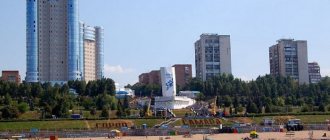
The annual outflow is approximately 30 thousand people. In the list of cities with problematic demographics, Smolensk ranks high. Young people en masse are trying to move closer to the capital or are leaving there to make ends meet. Smolensk residents have a choice of several higher educational institutions, about 10 state ones, and there are also specialized secondary schools. There are clearly no problems with overcrowding in the city. But people are constantly indignant at the actions of the authorities, who are deforesting and do not care about roads and housing and communal services. We have already become accustomed to constant interruptions in hot water and heating. The situation is even worse with the roads. Many people began to buy cars, which in no way contributes to comfortable traffic. Large buses are rare; they are massively replaced by minibuses, which have to be crowded into. Like large cities, during rush hour Smolensk gets up for long hours.
Smolensk used to have excellent tram service. The tracks were dismantled, but an alternative option was never provided to the population. The paradox of the municipality’s actions is to provide the city with a fleet of trams and trolleybuses, but there is no action to establish the infrastructure necessary for these types of transport. That’s why now everyone has switched en masse to minibuses.
Smolensk does not have enough kindergartens, there are enough schools. Many families have little hope that their child will be able to go to kindergarten for free before going to school. Densely populated areas (Kiselevka) suffer from overdevelopment. This leads to problems in schools, which, although they have places, are overcrowded. There are few companies where you can get a job. OSRAM and the Kristall enterprise are considered the most prestigious. The latter made Smolensk famous throughout the country with its exclusive products encrusted with diamonds. Smolensk remains an important railway junction, and there is also a railway station specializing in government contracts. For the female part of the population there is a knitting factory and large retail chains.
Latest Population Counts
The population of the Smolensk region in 2021 was 958,600 people. As of January 1 of this year, there were 690,000 (72%) urban residents, 268,600 (28%) rural residents. It should be noted that the western regions of the region are more populated than the rest. The smallest population is in the eastern regions (Temkinsky, Ugransky). The number of children and adolescents is 336,000. The population of the Smolensk region in 2021 decreased by 6,000 people compared to 2015.
Natural attractions
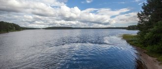
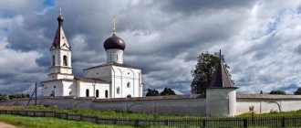
To preserve natural complexes, as well as for scientific purposes, the Smolensk Lake District was created in the region. This reserve received this name because of the 35 lakes that are part of it. Each of them is famous for its unique beauty. Visitors to the Smolensk Lake District plunge into a fabulous atmosphere. There are many historical monuments located on the territory of the reserve. One of them is the ancient ancient Russian city of Verzhavsk, which flourished in the 9th-12th centuries.
These amazingly beautiful places are also associated with the great traveler and explorer of Asian lands - N. M. Przhevalsky. Many tourists and locals know the famous spring called the “Holy Well”.
Yartsevo is a small but active town
On the territory of Yartsevo there are several enterprises that provide the population with work. Local residents have access to vocational education, which is provided by the Industrial College and the Avtokadry training complex.
Now the authorities are actively focusing on the development of industrial potential. In the entire region, Yartsevo is the most promising for attracting investment. Even foreign companies are ready to invest here. For a long time it was impossible to solve the housing problem, but in recent years a positive trend has emerged. Unfortunately, at the moment the city's population is steadily declining.
Architectural monuments
Among the most ancient architectural buildings in Smolensk, one can highlight the stone fortress. It was built under the leadership of Tsar Fyodor Ioanovich, since in the 16th-17th centuries territorial disputes arose between the Principality of Moscow and the Polish-Lithuanian Commonwealth. About 30,000 hired workers were used for this construction. This architectural monument consists of fortress walls and 38 towers, some of them reaching 33 meters in height. This is the most powerful wall of Russian times. The construction was supervised by the famous Smolensk master Fyodor Kon.
In the Smolensk region, like no other, monuments of Russian culture of the pre-Mongol period have been preserved. Here you can find works in the Baroque style, as well as unsurpassed examples of church construction.
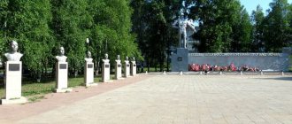
In Smolensk there are several memorial signs and complexes that capture the memory of many military events. Also, many monumental monuments dedicated to famous fellow countrymen appeared here. “The green necklace of the city” is what the residents of Smolensk call their parks and squares.
Major museums and Orthodox churches
Many people have heard of the village of Boldino, in the Smolensk region. Very often tourists go there on excursions. One of the oldest and most beautiful objects here is the Holy Trinity Monastery. It was founded by the Venerable Gerasim of Boldinsky back in the 6th century. This temple has already been restored several times, but it also continues to delight its visitors.
In the village of Novospasskoye, Smolensk region, there is the museum-estate of M. I. Glinka, where he once lived. This estate is the only monument dedicated to the famous Russian composer. The estate consists of a main two-story house, a kitchen annex, a guest room, a bakery, a carriage house, beautiful gazebos and a family temple. Very often guests of the estate hear the enchanting sounds of a piano.
In the village of Khmelita, Smolensk region, the former estate of the Griboyedov family has been preserved. Some features of this building can be recognized in his immortal comedy “Woe from Wit”. The palace and park ensemble includes a stone house, 4 outbuildings, a park with alleys, 2 ponds and a temple.
Between the villages of Gnezdovo and Katyn, Smolensk region, the Katyn memorial complex is located. For a very long time during the Soviet period, this place was not mentioned, since tragic events took place here in 1940. It was in the local forest that several tens of thousands of Polish officers and other prisoners were shot. The memorial complex is very young; it was opened in 2000. The main entrance to the memorial is made in the form of glass gates. In the center of the complex there is a high Orthodox cross, from which there is a Memory Alley.
A lot of churches were built in the Smolensk region, but from the pre-Mongol period only three have survived: the Intercession Church, the Assumption Cathedral, the temple of St. Sergius in the church of the Ascension Monastery.